Report
On the ascent to Nagay-Koshki peak (2090 m) via the eastern counterfort ("Botanik") 2A category of complexity by the FAKK team for the period 23.08.2020
I. Ascent Passport
| № | 1. General Information | |
|---|---|---|
| 1.1 | Full name, sports rank of the team leader | Khrabovchenko V.V., 2nd sports rank |
| 1.2 | Full name, sports rank of the participants | Bondarenko S., 2nd sports rank, Zhikhar R., 3rd sports rank, Ovcharenko D., 3rd sports rank |
| 1.3 | Full name of the coach | Kravchenko O.V., CMS, instructor 2 cat., Aristov I.E., MS, instructor 2 cat. |
| 1.4 | Organization | Federation of Alpinism of Krasnodar Krai |
| 2. Characteristics of the Ascent Object | ||
| 2.1 | Region | Lagonaki |
| 2.2 | Valley | Balka Medvezhanka |
| 2.3 | Section number according to the 2013 classification table | 2.1 |
| 2.4 | Name and height of the peak | Nagay-Koshki (2090 m) |
| 2.5 | Geographical coordinates of the peak (latitude/longitude), GPS coordinates (1) | 44.023821, 40.021837 |
| 3. Characteristics of the Route | ||
| 3.1 | Route name | V kontrforsu |
| 3.2 | Proposed category of complexity | 2A |
| 3.3 | Degree of route освоенности | – |
| 3.4 | Character of the route relief | Rocky |
| 3.5 | Route elevation gain (altimeter or GPS data) | 190 m |
| 3.6 | Route length (in m) | 270 m |
| 3.7 | Technical elements of the route (total length of sections of varying complexity with indication of relief character (ice-snow, rocky)) | I cat. complexity rocks — 50 m. II cat. complexity rocks — 150 m. III cat. complexity rocks — 50 m. IV cat. complexity rocks — 20 m. |
| 3.8 | Descent from the peak | Along the trail, alpine and subalpine meadows, forest to Partizanskaya Polyana |
| 3.9 | Additional route characteristics | There is no water on the route from July to November. In the rest of the time, there is snow in the karst sinkholes of the Kamennoye More ridge |
| 4. Characteristics of the Team's Actions | ||
| 4.1 | Time of movement (team's walking hours, in hours and days) | 5 hours |
| 4.2 | Overnight stays | Partizansky refuge |
| 4.3 | Start of the route | 10:30, 23.08.2020 |
| 4.4 | Reaching the peak | 15:30, 23.08.2020 |
| 4.5 | Return to the base camp | 19:30, 23.08.2020 |
| 5. Responsible for the Report | ||
| 5.1 | Full name, e-mail | Khrabovchenko V.V., hrabovchenko@mail.ru |
II. Ascent Description
1. Characteristics of the Ascent Object
The Nagay-Koshki peak (2090 m) is the highest point of the Kamennoye More ridge. The ridge is located on the Lagonaki highland (Western Caucasus).
The approach to the route begins from the Partizansky refuge on the eponymous clearing. The refuge is accessible via an asphalt road from the Guzeripl settlement. The approach to the refuge is possible from nearby cities by car: from Maykop (about 2 hours) and Krasnodar (about 3.5 hours).
From the refuge, the peak is clearly visible. The approach begins along the trail from the pull of the poma: first through the forest, then along a large talus — exit to the ridge with alpine meadows, leading directly to the start of the route. Approach time — about 1.5–2 hours.
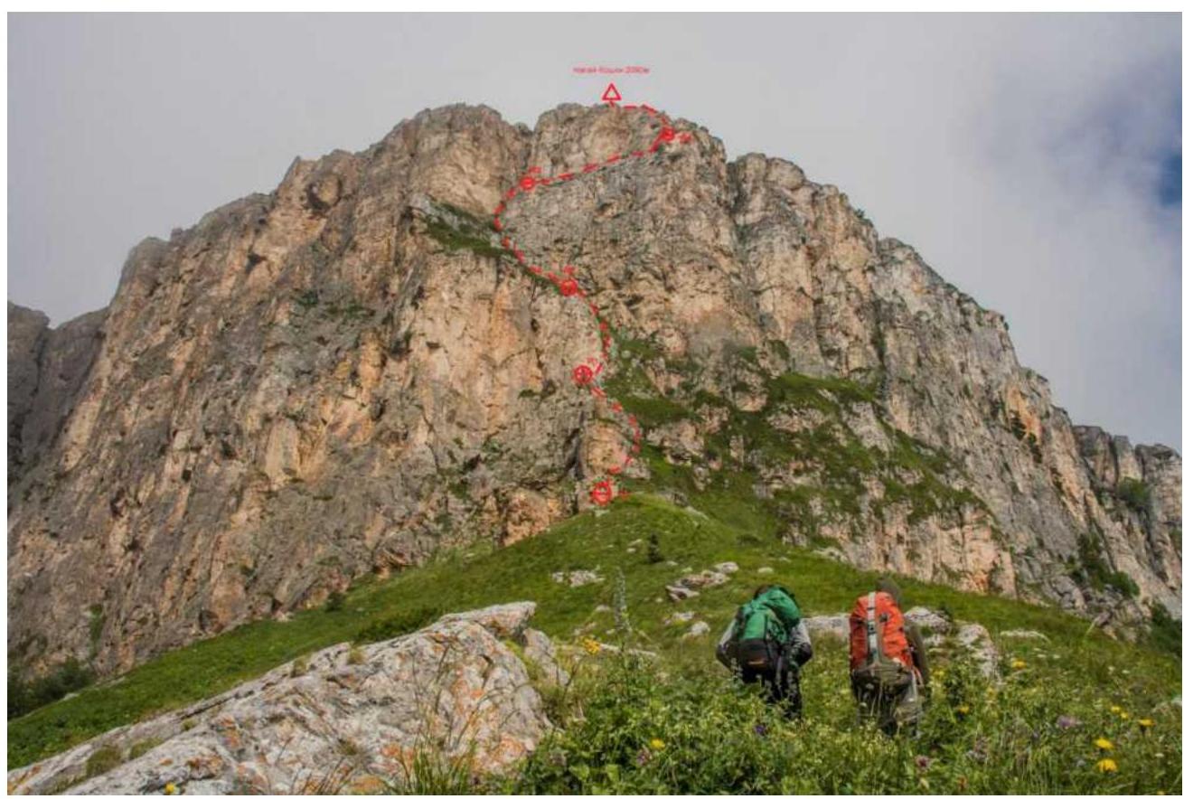
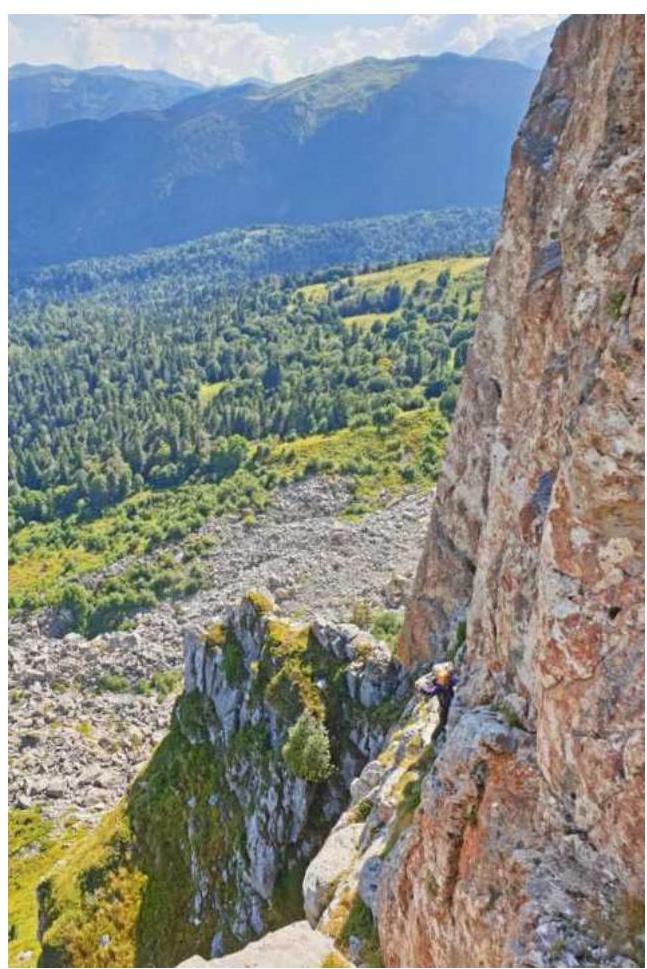
1.1. General photo of the peak (taken from the approach) with the route taken by the team
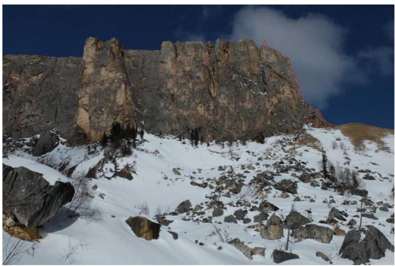
1.2. Photo of the route profile (route line applied to the photograph taken on February 15, 2015)
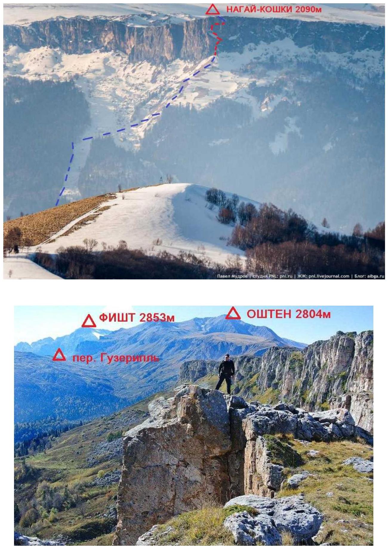
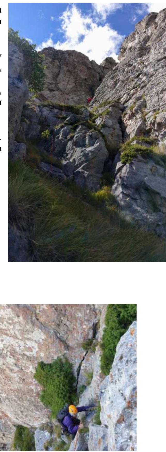
1.3. Photopanoramas of the area (Kamennoye More ridge with the route thread in red and the approach in blue) and from the Nagay-Koshki peak with indication of peak names, their heights, and passes
1.4. Map of the area and schematic map of the ascent object (approach from Partizansky refuge marked in red)

2. Characteristics of the Route
2.1. Technical photograph of the route is provided in section 1.1.
2.3. Technical characteristics of the route sections
| Section № | Relief character | Category of complexity | Length, m | Type and number of hooks |
|---|---|---|---|---|
| R0–R1 | Rocky ridge | I–II | 60 | 4 |
| R1–R2 | Wall, inclined shelf | III–II | 60 | 5 |
| R3–R4 | Chimney | III–IV | 60 | 6 |
| R4–R5 | Shelf, chimney | I–IV | 50 | 4 |
| R5–peak | Rocky ridge | II | 40 | 3 |
3. Characteristics of the Team's Actions
3.1. Brief description of the route passage.
Station R0 on a ledge at the foot of the counterfort. From the station upwards (II) along the destroyed wall and then left along the ridge (I). There are loose rocks on the ridge. Up the ridge to a shoulder with a convenient place for belaying on a large ledge (station R1).
From station R1 upwards-right along the wall (III, 10 m) and then exit to an inclined grass-covered shelf (in winter and spring, there is snow on the shelf). Here, a rock hook is found, and a blocked station on two hooks. The hooks are presumably left by MS Viktor Afanasyev.
Up the shelf to the start of the chimney (I, 20 m).
Station R2 on a ledge to the left at the beginning of the chimney.

From station R2, right into the chimney or left along the wall, stemming for about 10 m (III).
In the crack, medium camalots fit well. Then, exit to a gentle shoulder at the base
of a large chimney leading directly to the peak. Movement along the right wall of the chimney,
then after 5–7 m, transition into the chimney and stemming under the plug (IV, 10 m). This
is the key point of the rope (see photo). Bypass the plug on the right and exit to a shelf.
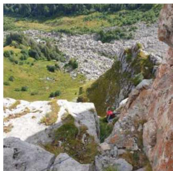
Station R3 on a large ledge on the shelf
From R3 along the narrowing shelf to the right (narrow cracks fit small stoppers and anchors) to the start of the chimney (I, 25 m). A psychological spot — behind the back, a depth of more than 150 m.
Chimney (IV, 10 m) is passed initially with stemming, then with back pressure against one of the walls.
On the left wall of the chimney, there are a couple of niches for medium camalots. Exit from the chimney
(see photo) to the ridge shoulder. Station R4 on a ledge
From R4 (see photo) along the ridge with convenient handholds upwards for about 40 m to the peak (II).
Station R5 on the edge of the cuesta on a ledge or sitting on the peak with self-belaying at the peak menhir.
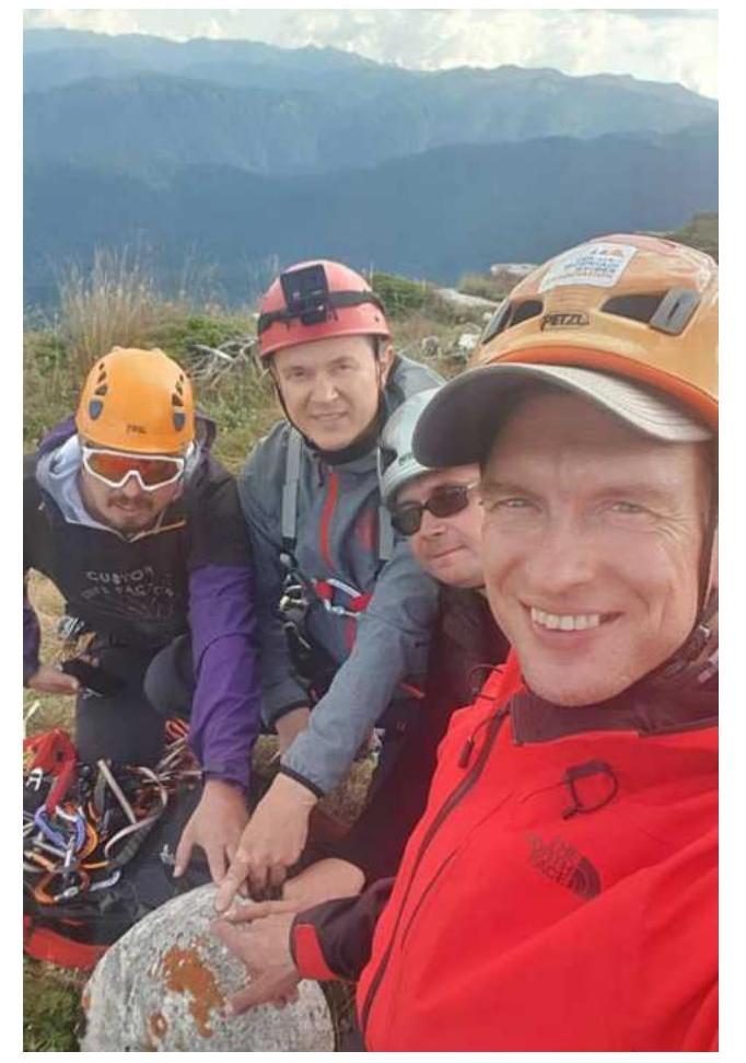
3.2. Photo of the team on the peak at the control tour (menhir)
3.3. Assessment of the route's safety.
Cellular communication on the route is possible at the Partizansky refuge (MTS operator).
Recommendations for climbers:
- Rock shoes in summer
- Large loops (repschnur) at stations on ledges
- Set of camalots for intermediate points
- Headlamp for descent from the peak in twilight
- Trekking poles for approach and descent
Descent from the peak on foot along the trail towards Instruktorskaya Shchel and then down through subalpine meadows and forest to the road from Partizansky refuge to Yavorovaya Polyana. Along the road return to the refuge.
Conclusion on the preliminary assessment of the route in comparison with classified routes of the same category of complexity, available in the climbing experience of the team members.
To assess the complexity, the team used the following routes climbed on Lagonaki highland and in neighboring Arkhyz (with indication of the route number according to KMB 2020):
- Kelbashi 1B from the ridge through Karadzhash pass
- Oshten 1B NE ridge and from the slope
- Peshtera 2B from the ridge
- Fisht 1B from the slope
- Fisht 2A NW ridge
The route climbed is not inferior in complexity to 2B category routes. In winter, the complexity of passage increases due to:
- snow on shelves;
- snow on rocks.
Considering the short length, the overall category of complexity is assessed by the team as 2A.