Report
On the first ascent to the summit "Pik 3305", made by a group of climbers from the Stavropol region on May 5, 1980, in the Arkhyz mountain region (Western Caucasus) of the Stavropol region, west of the "Marukh" pass, Sofiyskiy ridge.
The Arkhyz mountain region is located on the northern slopes of the Main Caucasian Range between the Kardyvach region (Krasnodar region) to the west and the "Marukhskiy" pass to the east. The region is entirely within the Stavropol region and is located within 43° north latitude. North of the Main Caucasian Range lies the Sofiyskiy ridge, where this unnamed peak with an elevation of 3305 meters above sea level is located.
The base camp was situated at an altitude of 1320 m above sea level, 1.5 km from the "Lednikovaya" farm. From the base camp, the route went upstream along the Sofia River to the tributary from the Ak-Ayry glacier, then up to the "barany lby" (ram's foreheads), and from there to the right into a wide couloir that led to the firn fields. And then further up to the "Stolichny" pass — a 3-hour walk from the camp.
The "Pik 3305" summit is a rocky massif on the crest of the Sofiyskiy ridge, approached by several powerful counterforts from the north. To the south, it ends in a ridge leading to "Pik 3200", v. Nadezhda 3353, and further to v. Sofia 3640 m. The northern side of "Pik 3305" continues with a ridge leading to "Pik 3231" and further to the Mingi-Kyol-Bashi 3230 m peak.
The ascent route is combined — rock and snow, ridge. The character of the rocks: mostly heavily destroyed and snow-covered.
The qualification of the group that made the first ascent is quite high — 1st sports category, three of the climbers being instructors-methodologists in mountaineering.
The ascent was tactically competent. The description of the ascent route, passport, table of main characteristics, map scheme, photographs, and other materials are attached.
Group composition:
- Khamtsov A.P. — 1st sports category, instructor 2nd category, team leader;
- Karpov E.V. — 1st sports category, instructor 2nd category;
- Redozubov V.I. — 2nd sports category, instructor 3rd category;
- Cherkashin V.M. — 1st sports category;
- Melkov V.P. — 1st sports category;
The group left the camp at 5:00 and returned at 17:30 on May 5, 1980. The group trainer was Comrade Rogovskiy V.P.
Description
Of the ascent route to the summit "PIK 3305" via the North-West ridge. (Approximate)
From the base camp located on a clearing near the Syrzavod, upstream along the Sofia River to the tributary from the Ak-Ayry glacier. Along the left (orographic) side of the tributary up to the "Baraniy lby" (ram's foreheads) — 1–1.5 hours from the base camp. From the "Baraniy lby" to the right up to the "Stolichny" pass, another 1–2 hours.
From the pass to the left up along the North-West ridge. Along the несложным rocks on the left (in the direction of travel) side of the ridge, exit under a gendarme resembling an "iron" (200 m from the pass).
The "iron" gendarme is one of the key locations, representing a rock wall with a steepness of 80–85° and a length of 10 m. The wall is monolithic with a chimney in the center, which is plugged. This section should be passed to the left of the chimney, with piton belay.
Further up the ridge, 8 ropes of несложного climbing. On the way, several gendarmes are passed head-on or to the right in the direction of travel.
After the last of the small gendarmes, a steep ridge (50°) with a length of 2 ropes leads to a dip.
The descent into the dip is made to the right in the direction of travel along crumbling rocks, 40 m, with an exit into a hollow under the "Rocky feathers".
Further along the ridge, 160 m in the direction of the couloir, leading to the saddle of the pre-summit shoulder.
The exit to the saddle is via the indicated 40-meter couloir, with piton belay.
From the saddle, on the right side of the pre-summit shoulder, exit into a large central couloir, along which 250 m, sticking to the edge of snow and rocks, exit onto the saddle, with piton belay and through outcrops. The steepness increases to 50° as you ascend. (Rockfall hazard).
From the saddle, 15 m to the right along a heavily destroyed rocky ridge to the summit.
The ascent to the summit from the pass took 4.5 hours. Descent:
- via the ascent route;
- or, if the snow cover is in good condition, via the South-East couloir.
The descent took 4 hours.
RECOMMENDATIONS:
- Rock pitons — 8–10 pcs.
- Hammers — 2 pcs.
- Repschnur — 10 m.
- Main rope — 40 m (one per rope team)
Photo 4. Summit.
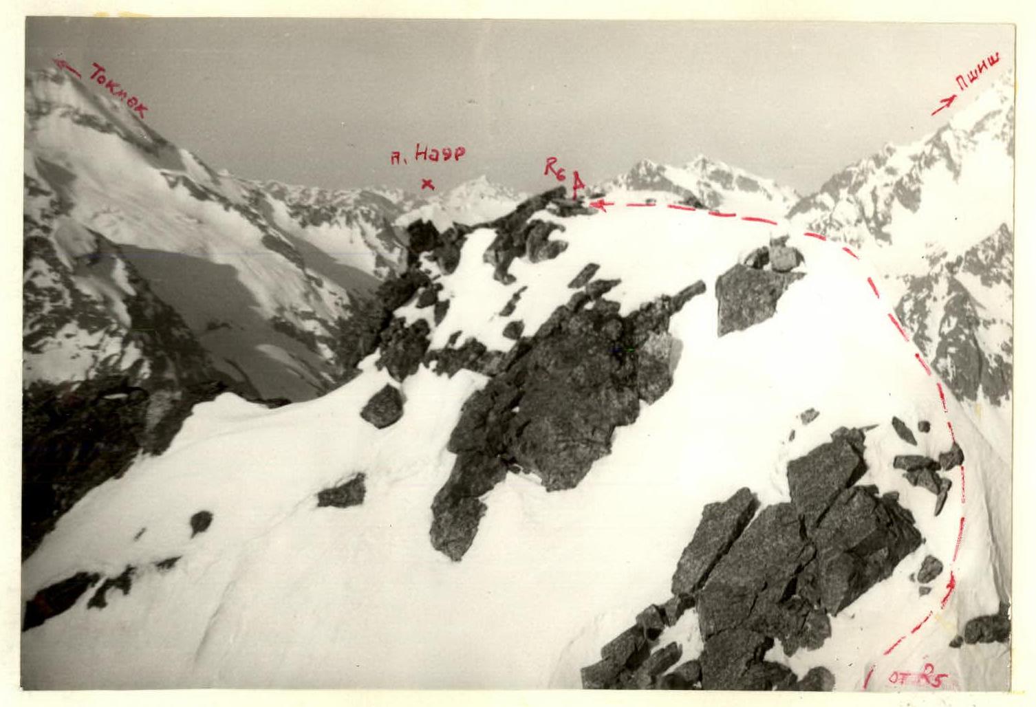
Photo 3. Section R5–R6. View from the pre-summit (from R5). In the background — Pshish peak.

Photo 1. Pre-summit.
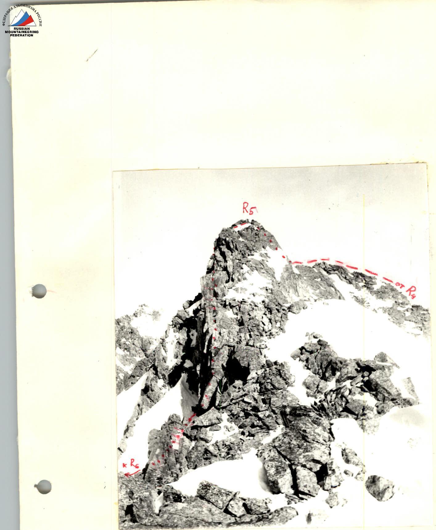
Photo 2. Descent from the pre-summit via rappel.


TABLE OF MAIN CHARACTERISTICS OF THE ROUTE
| Date | Section designation | Steepness | Length | Character of relief | Difficulty | Condition | Weather conditions | Pitons | Ice ax | Snow |
|---|---|---|---|---|---|---|---|---|---|---|
| May 5, 1980 | R0–R1 | 30° | 200 m | ridge | 1 | destroyed | good | simultaneous movement | ||
| —"— | R1–R2 | 80° | 10 m | wall | 5 | monolithic | —"— | 2, 1; | ||
| —"— | R2–R3 | 25° | 300 m | ridge | 2 | destroyed | —"— | outcrops (simultaneously) | ||
| —"— | R3–R4 | 50° | 80 m | ridge | 3 | destroyed | —"— | outcrops (alternately) | ||
| —"— | R4–R5 (descent) | 40° | 40 m | ridge | 4 | destroyed | —"— | 1; outcrops; | ||
| —"— | R5–R6 | 45° | 160 m | ridge | 2 | destroyed | —"— | outcrops; | ||
| —"— | R6–R7 | 40° | 40 m | inner corner | 4 | widely destroyed | —"— | 2; outcrops; | ||
| —"— | R7–R8 | 50° | 250 m | edge of snow and rocks | 3 | rocks icy | —"— | 2; outcrops; | ||
| —"— | R8–R9 | 10° | 15 m | ridge | 2 | destroyed | —"— | outcrops; |
Exit to the route at 5:00 — 5 hours of climbing to the summit. Descent from the summit — 4 hours. There were no overnight stays on the route. The descent to the camp was made at 17:30 on May 5, 1980.
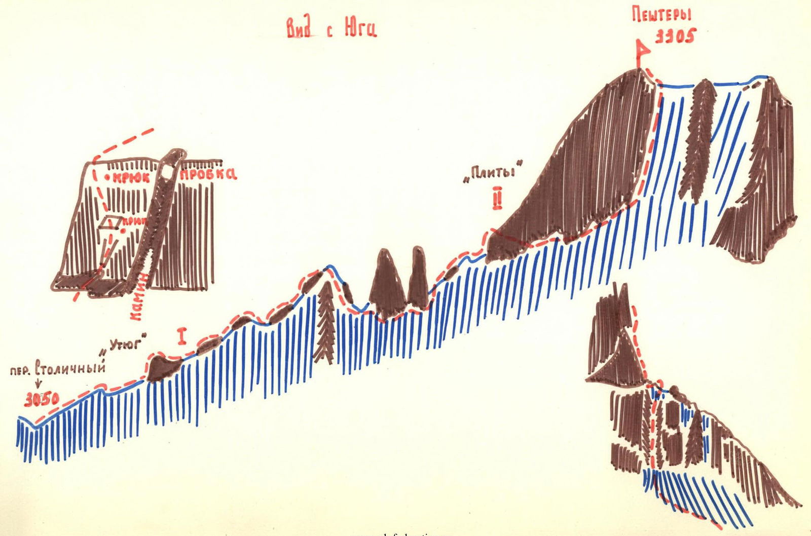
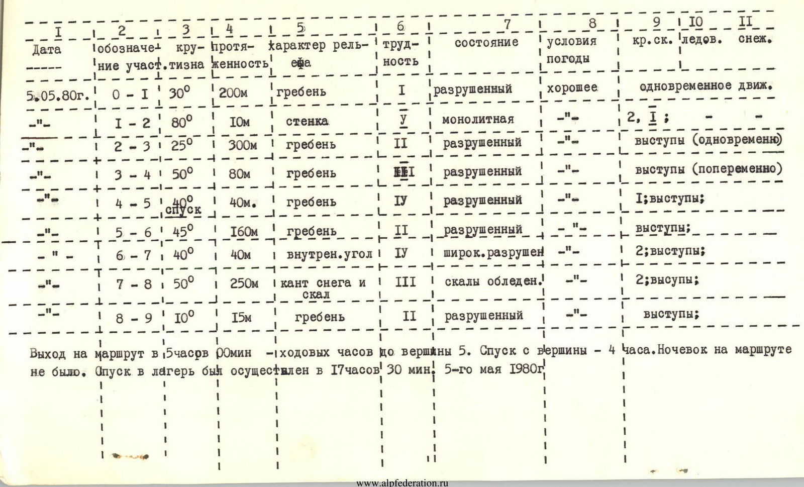
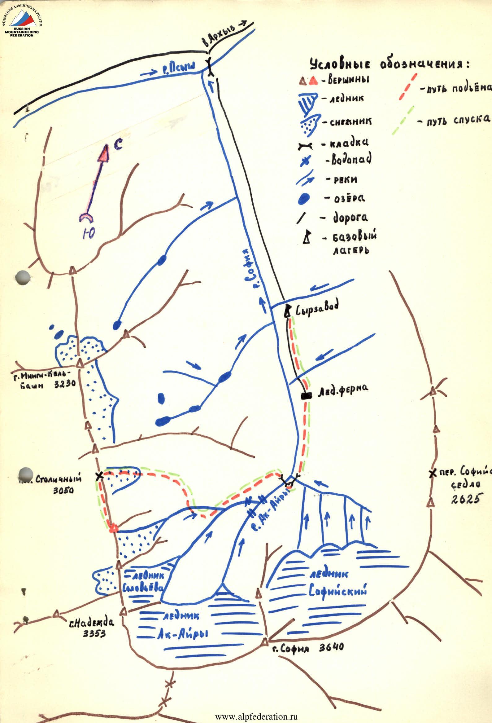
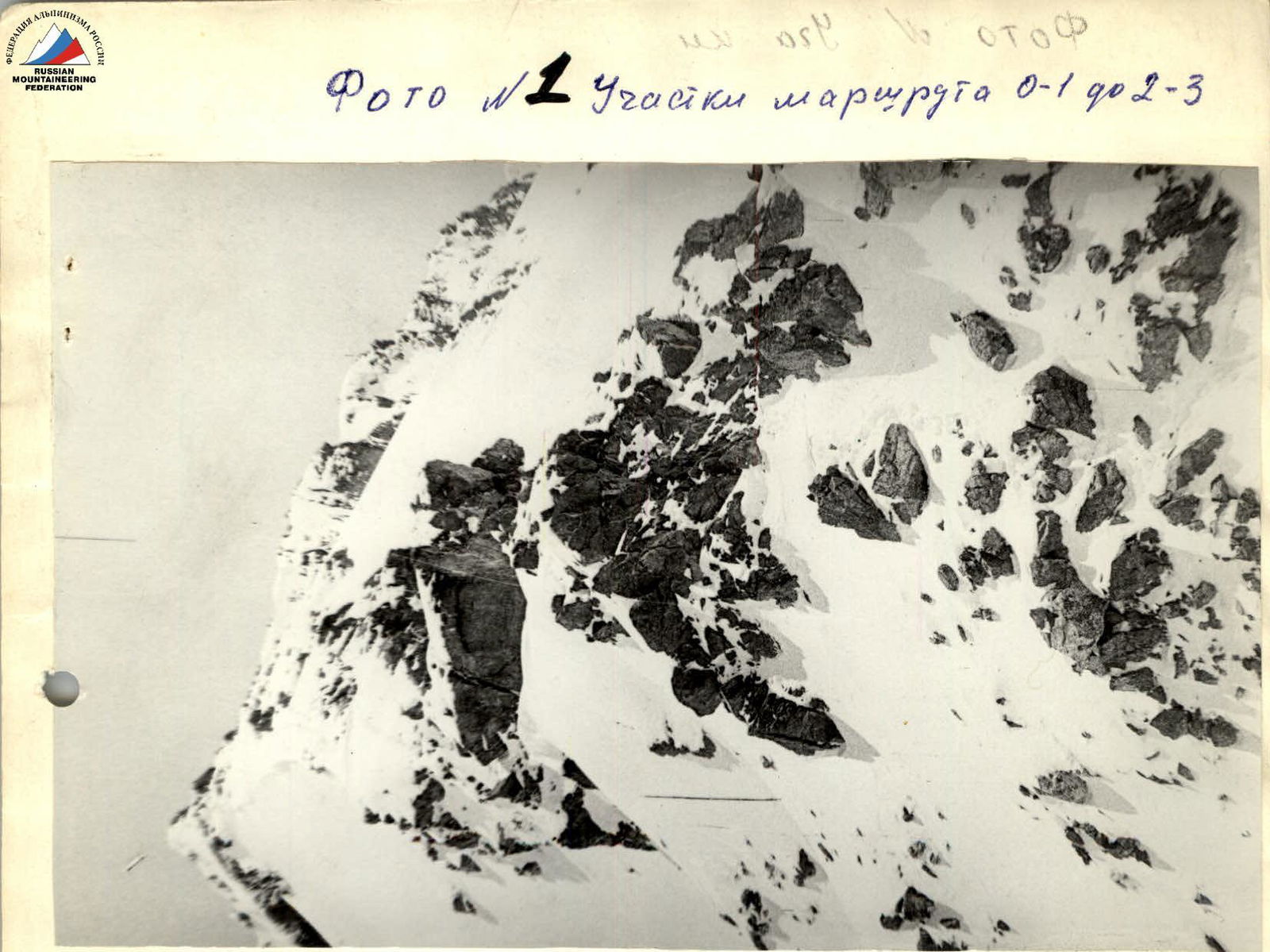
Photo #1 Sections of the route R0–R1 to R2–R3.

Photo #2 Sections of the route R2–R3 to R3–R4.
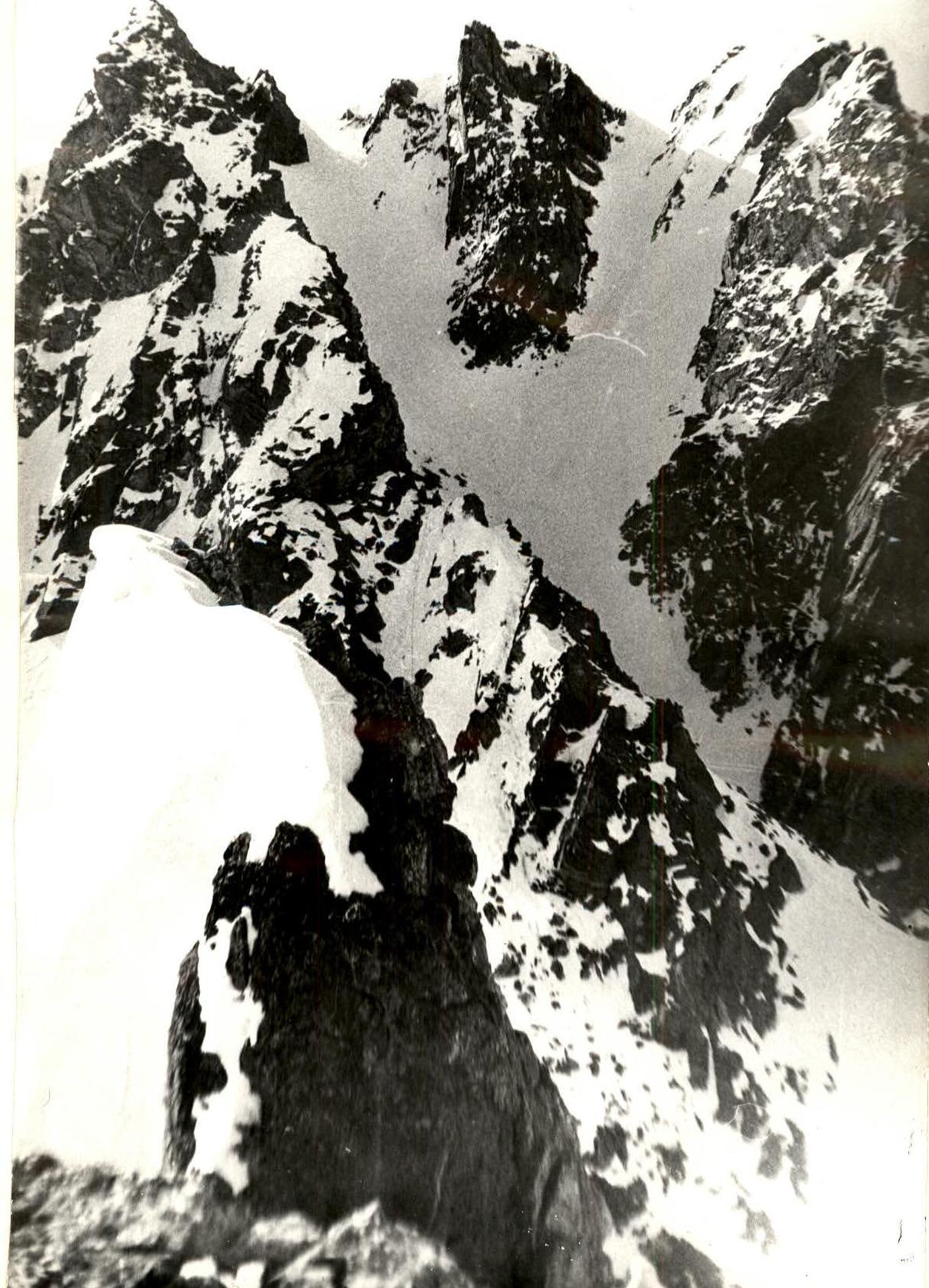
Photo #3 Sections R5–R6; R6–R7; R7–R8; R8–R9. Note: Section R4–R5 is not visible (in the photo), the photo is taken from the start of the descent to the hollow. 2) Section R5–R6 is not visible. It passes on the right side of the "rocky feathers" visible on the foreground edge.