The unnamed peak "3160 m" (absolute height according to the state topographic map M 1:25 000) is located in the middle part of a heavily dissected rocky massif, towering above the Karadjazh tract in the Northwest end of the Sofiyskiy ridge on its segment from the Karadzhash pass to the peak "Dimitrov-100".
To the Northwest of it is:
- the peak named after Bulgaro-Soviet friendship (3226 m)
To the Southeast is the Unnamed peak (conditionally "3100"), the first route to which has not yet been laid (photo I).
The peak "3160", as an object of first ascent, was chosen during reconnaissance group trips in November and December 1981, as well as January 1982 and was approved by the coaching council of the joint Soviet-Bulgarian expedition "Arkhyz-82".
The most acceptable route for the first ascent seemed to be (in its initial part) along the steep snowy slope of the Northeast exposure to the saddle between the peaks named after Bulgaro-Soviet friendship and "3160". The relative avalanche safety of this path was assessed during the last reconnaissance (within the framework of "Arkhyz-82") on April 30, 1982 by a snow and avalanche specialist of the VGI, candidate of geographical sciences A. Runich.
The nearest classified peak - "3200", 1B cat. difficulty - is located to the Southwest of the Stolicny pass (see the overview orographic scheme).
The approach to the start of the route can be made in two ways:
- from the "Syrzavod" clearing up the r. Kashka-Eshek
- from the "Sofia" shelter up the r. Gammash-Chat
The first path option is doubtful in terms of avalanche safety and, at least until the beginning of May, it is not recommended. The second is more preferable.
The group of first ascenders used the approach from the "Sofia" shelter. This path is described below.
From the "Sofia" shelter (abs. mark 1830 m), through the snow (it melts in the vicinity of the shelter on May 10-20), up the r. Gammash-Chat to the first ledge, the ascent to which is carried out on the right along the cones of avalanches descending in winter from the peak named after Zaimov ("Zaimov-peak", 3011 m). At the top - a lake, known as "Zapятая". To the right of the lake (covered with snow until the end of May), along the snowy slope, to the base of the second ledge. On the right part of the base - a wide snow couloir. On it to the upper, inclined part of the ledge. Turn right and with approximately 20-degree ascent to the site of the assault camp in the immediate vicinity of the start of the route.
Overnight stay - on the snow, at the base of the rocky spur, coming from the peak named after Bulgaro-Soviet friendship (see diagram). Absolute mark - 2700 m.
From the "Sofia" shelter to overnight stay - 4-6 hours walking, depending on the state of the snow.
Route description
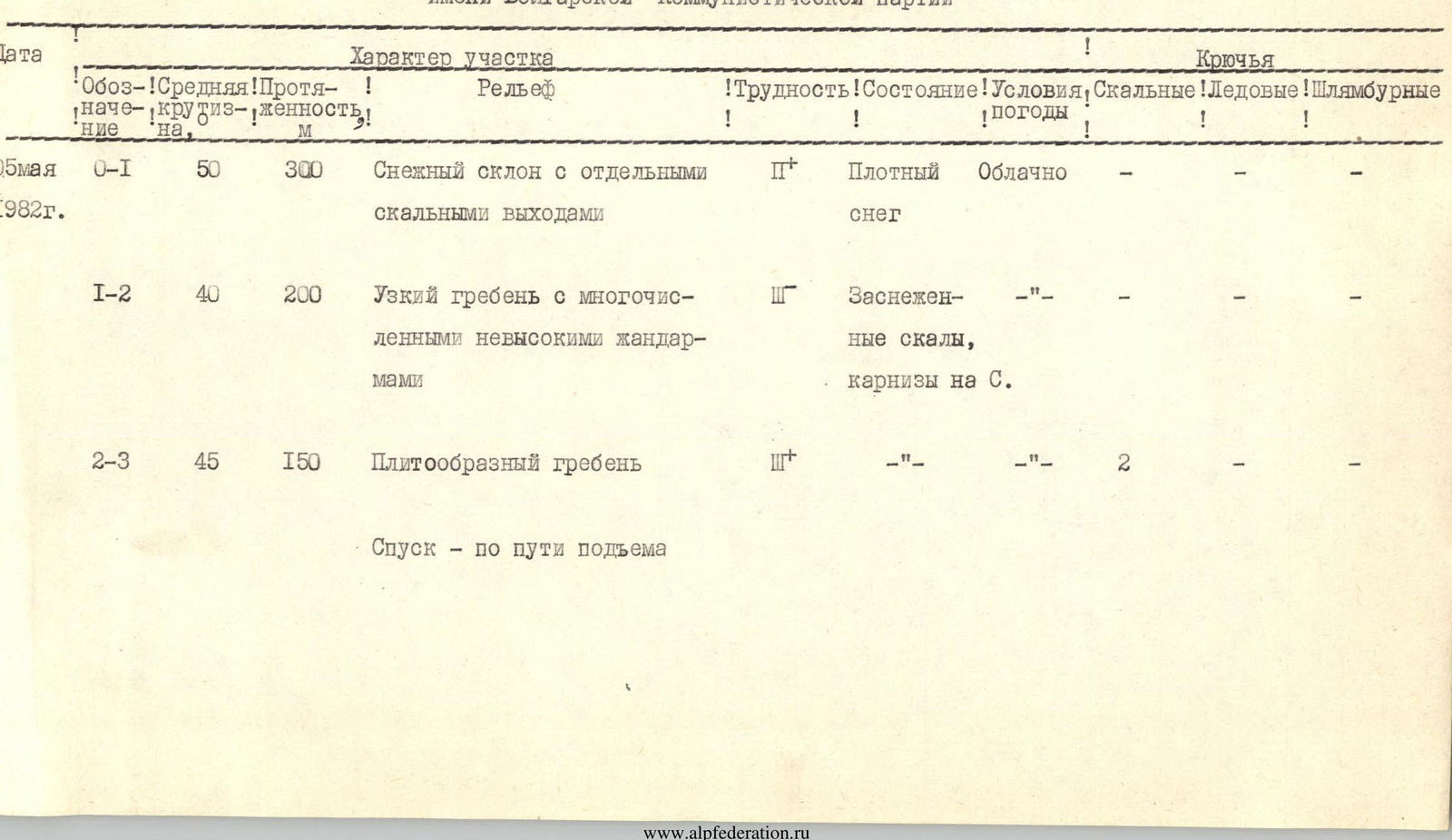
From the overnight stay, with a 60 m ascent along the snowy, on average 35-degree slopes, to the base of the Northeast slope under the saddle between the peaks "3160" and named after Bulgaro-Soviet friendship.
Absolute mark - 2760 m. Slope steepness: from 35 ° at the beginning to 60 ° when exiting to the saddle. Section R0-R1. In rope teams, on snow, alternate motion straight up between rocky outcrops in the direction of the saddle, having an absolute mark of 2980 m. From 2930 m the slope steepness increases to 55-60 °. Ascent in 3 tactics. Ropes. Avalanches descending from the Southeast ridge of the peak named after Bulgaro-Soviet friendship and the Northwest ridge of the peak "3160" go around the mentioned rocky outcrops, obviously not overlapping (photo 2). Nevertheless, it is necessary to carry out the ascent in the early morning. The ascent to the saddle takes 2 hours. Section R1-R2. From the saddle, turn to the Southeast and along the sharp ridge (rocks covered with snow, cornices to the North!) adhering to its right side, in places along the knife-like watershed part, overcoming numerous gendarmes mainly "head-on", to the failure before the pre-summit tower. 1 hour. Section R2-R3. To the pre-summit tower leads a wide slope composed of crystalline schist slabs, in places completely covered with snow, with a steepness of 60 °. The last 30 m in height straight up along the icy slabs (photo 3). 1 hour. There are few characteristic places on the route along the ridge. To the right and left - steep slopes, in places turning into walls. To the SE from the summit point - a wall-like failure towards another Unnamed peak - the first to the NW from the Karadzhash pass.
No traces of human presence were found on the summit. A cairn is being built for the first time. Descent - along the ascent path. Takes 1.5-2 hours. When descending from the saddle, a section of 60-degree slope requires maximum attention and organization of reliable insurance. From the overnight stay (assault camp) to the overnight stay, the group spent 5 hours 30 minutes.
The leaders and participants of the first ascent evaluate the route as corresponding to 2A cat. difficulty.
The group of first ascenders appeals with a request to assign the peak the name "Bulgarian Communist Party" (BCP). Georgy Mikhailovich Dimitrov, in honor of the 100th anniversary of whose birth the joint Soviet-Bulgarian expedition "Arkhyz-82" was organized by the Stavropol Territory Sports Committee and the Stavropol Alpine Federation, stood at the origins of the Bulgarian Communist Party and bequeathed to faithfully preserve and develop friendship between the Bulgarian and Soviet peoples.
A possible subsequent first ascent route is along the short but very steep SE ridge from the saddle between the peaks "3160" and "3100", 3B cat. difficulty (with ascent to the saddle from the North).
Leaders: from the Bulgarian People's Republic - N. Semerdzhiev, member of the BCP
from the USSR - E. Zaporozhchenko, member of the CPSU
May 16, 1982, Pyatigorsk
TABLE of main characteristics of the route of the first ascent to the peak named after the Bulgarian Communist Party