
REPORT
on the first ascent of the mountaineering route to the summit 2970 m (60 years of KChAO) "via the North Edge", carried out within the framework of the qualifying competitions "Stavropol Regional Mass Alpinada "Vakhta Pamyati - 2013", dedicated to the Victory Day in the Great Patriotic War (1941-1945)"
ASCENT PASSPORT
- Region, gorge, section number according to the 2010 classification table:
- Caucasus. 2.1. Krasnodar and Stavropol territories up to Marukh pass.
- Name of the summit, its height, name of the route: Summit 2970, height 2970, route name — via the North Edge.
- Proposed — 4B category of complexity, first ascent.
- Nature of the route: combined.
- Height difference of the route: 478 m (by GPS). Route length: 970 m. Length of route sections by category of complexity:
- 1 cat. diff. – 120 m
- 2 cat. diff. – 527 m
- 3 cat. diff. – 213 m
- 4 cat. diff. – 63 m
- 5 cat. diff. – 47 m
- 6 cat. diff. – 0 m Average steepness of the route: main (rocky) part — 57°, total route – 47°.
- Used (left "pitons" on the route): total – 48/0, including:
- pitons — 25/0;
- chock stones — 15/0;
- friends — 8/0.
- Team's total climbing hours: 14 h 50 min.
- Descent from the summit: to Zapyataya lake (upper) – 1 cat. diff.
- Leader: Iver Evgeny Vasilyevich, 1st sports category, instructor-methodologist 3rd category; Participants: Zhamgochyan Mikhail Alexandrovich, 2nd sports category; Zhambalov Sergey Leonidovich, 2nd sports category.
- Coach: Yenin Vladimir Ilyich, Candidate Master of Sports, instructor-methodologist 1st category; Responsible for safety: Magomedov Ruslan Rasulovich, Candidate Master of Sports, instructor-methodologist 1st category.
- Start of the route: 4:20, May 7, 2013; Summit reached: 17:30, May 7, 2013; Return to overnight stay: 19:10, May 7, 2013.
- Organization: Stavropol Regional Federation of Mountaineering (SRFM).
- Responsible for the report — Iver Evgeny Vasilyevich. Phone: +7 (918) 603 76 48. Email: evgeniy.iver@gmail.com
GENERAL PHOTO OF THE SUMMIT
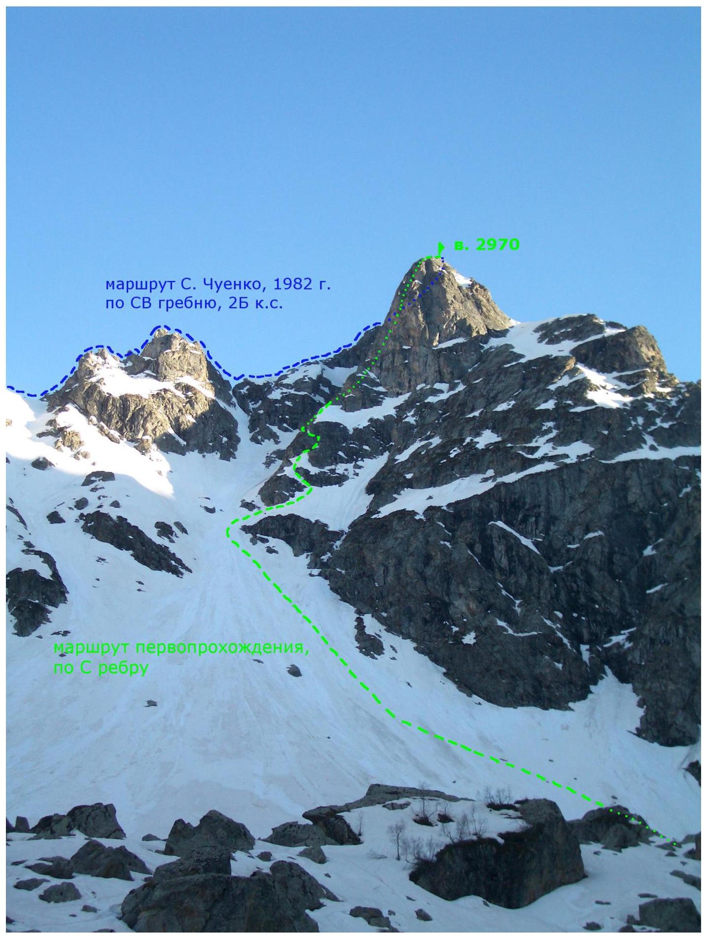
Photograph No. 1. Taken on May 8, 2013, from the slope of summit 3011 (Zaimov peak).
PHOTO OF THE WALL PROFILE

Photograph No. 2. Taken on May 7, 2013, from the slope between summits 3210 and 3011.
PHOTO PANORAMA OF THE AREA
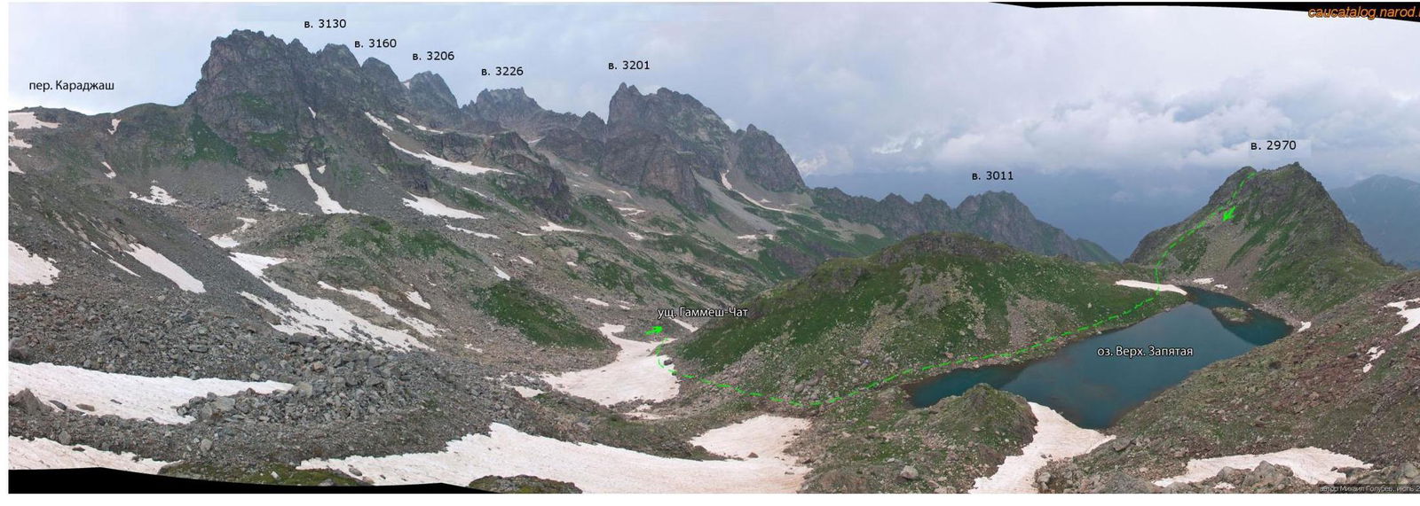
Photograph No. 3 (author Mikhail Gолубев, July 2010). Taken from the saddle between Pehtera and Kelbashi peaks. The dotted line indicates the descent path from the summit to Zapyataya lake (lower).
MAP OF THE ASCENT AREA

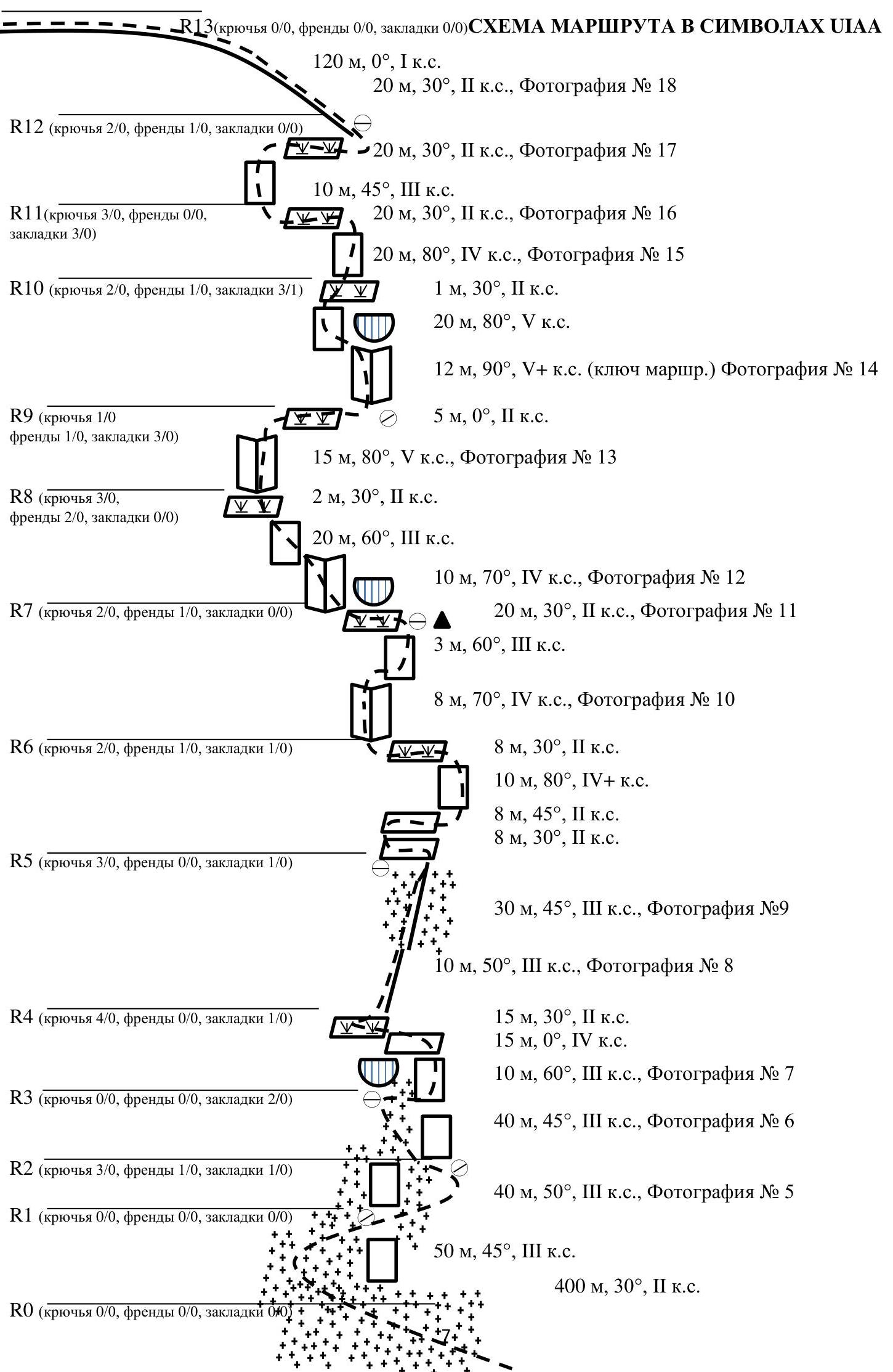
ROUTE SCHEME IN UIAA SYMBOLS
R0 (pitons 0/0, friends 0/0, chocks 0/0)
- 400 m, 30°, 2 cat. diff.
R1 (pitons 0/0, friends 0/0, chocks 0/0)
- 50 m, 45°, 3 cat. diff.
- 40 m, 50°, 3 cat. diff., Photograph No. 5
R2 (pitons 3/0, friends 1/0, chocks 1/0)
- 40 m, 45°, 3 cat. diff., Photograph No. 6
R3 (pitons 0/0, friends 0/0, chocks 2/0)
- 10 m, 60°, 3 cat. diff., Photograph No. 7
- 15 m, 0°, 4 cat. diff.
- 15 m, 30°, 2 cat. diff.
R4 (pitons 4/0, friends 0/0, chocks 1/0)
- 10 m, 50°, 3 cat. diff., Photograph No. 8
- 30 m, 45°, 3 cat. diff., Photograph No. 9
R5 (pitons 3/0, friends 0/0, chocks 1/0)
- 8 m, 30°, 2 cat. diff.
- 8 m, 45°, 2 cat. diff.
- 10 m, 80°, 4+ cat. diff.
- 8 m, 30°, 2 cat. diff.
R6 (pitons 2/0, friends 1/0, chocks 1/0)
- 8 m, 70°, 4 cat. diff., Photograph No. 10
- 3 m, 60°, 3 cat. diff.
- 20 m, 30°, 2 cat. diff., Photograph No. 11
R7 (pitons 2/0, friends 1/0, chocks 0/0)
- 10 m, 70°, 4 cat. diff., Photograph No. 12
- 20 m, 60°, 3 cat. diff.
- 2 m, 30°, 2 cat. diff.
R8 (pitons 3/0, friends 2/0, chocks 0/0)
- 15 m, 80°, 5 cat. diff., Photograph No. 13
- 5 m, 0°, 2 cat. diff.
R9 (pitons 1/0, friends 1/0, chocks 3/0)
- 12 m, 90°, 5+ cat. diff. (key section), Photograph No. 14
- 20 m, 80°, 5 cat. diff.
- 1 m, 30°, 2 cat. diff.
R10 (pitons 2/0, friends 1/0, chocks 3/1)
- 20 m, 80°, 4 cat. diff., Photograph No. 15
R diff. (1 cat. diff.)
- 20 m, 30°, 2 cat. diff., Photograph No. 16
- 10 m, 45°, 3 cat. diff.
- 20 m, 30°, 2 cat. diff., Photograph No. 17
R12 (pitons 2/0, friends 1/0, chocks 0/0)
- 20 m, 30°, 2 cat. diff., Photograph No. 18
- 120 m, 0°, 1 cat. diff.
TECHNICAL PHOTO OF THE ROUTE
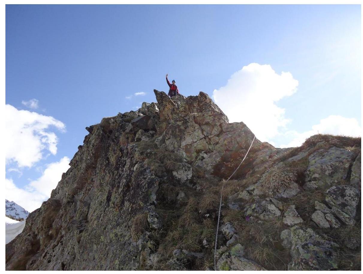
Photograph No. 4. Taken on May 7, 2013, from the NE ridge of summit 2970.
BRIEF DESCRIPTION OF THE ROUTE PASSAGE
The idea of the first ascent to summit 2970 (60 years of KChAO) via this route belongs to the Senior Coach of the Qualifying competitions "Stavropol Regional Mass Alpinada "Vakhta Pamyati - 2013"", Yenin Vladimir Ilyich (Candidate Master of Sports, instructor-methodologist 1st category, judge for mountaineering 1st category).
The approach to the start of the route from the overnight stay at Zapyataya lake (lower) goes along the right part of the Gammash-Chat gorge, under the slopes of summit 3011. Not reaching the "ram's foreheads", we turn left towards the Northeast ridge of summit 2970.
Section R0–R1 — snow ascent in the direction of the Northeast ridge of summit 2970.
- The beginning of the ascent (400 m, 30°, 2 cat. diff.) — simultaneous movement.
- Then, when bypassing the wall (50 m, 45°, 3 cat. diff.) and approaching under the North Edge — the steepness increases.
- With dense snow cover — alternate belay.
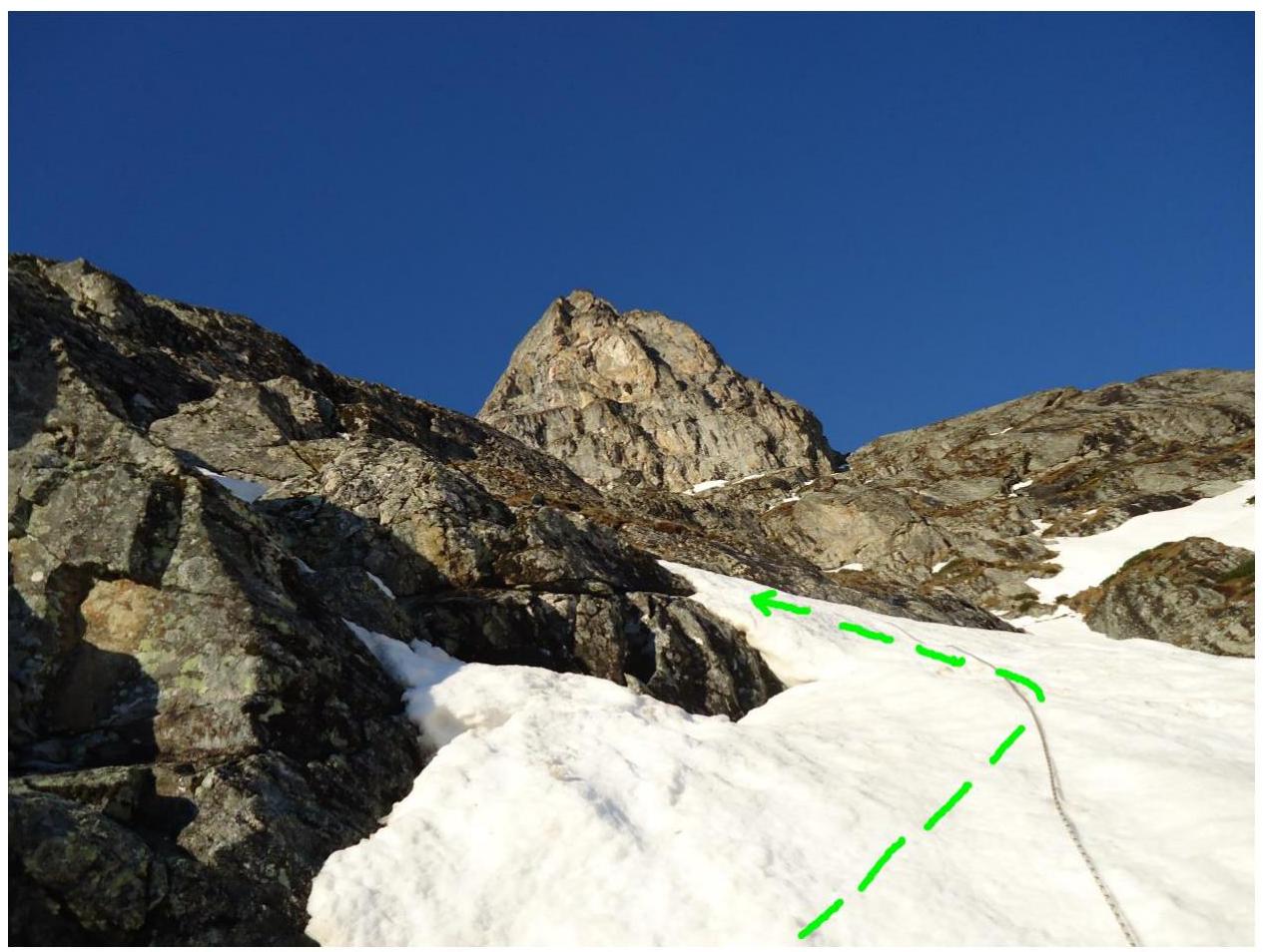
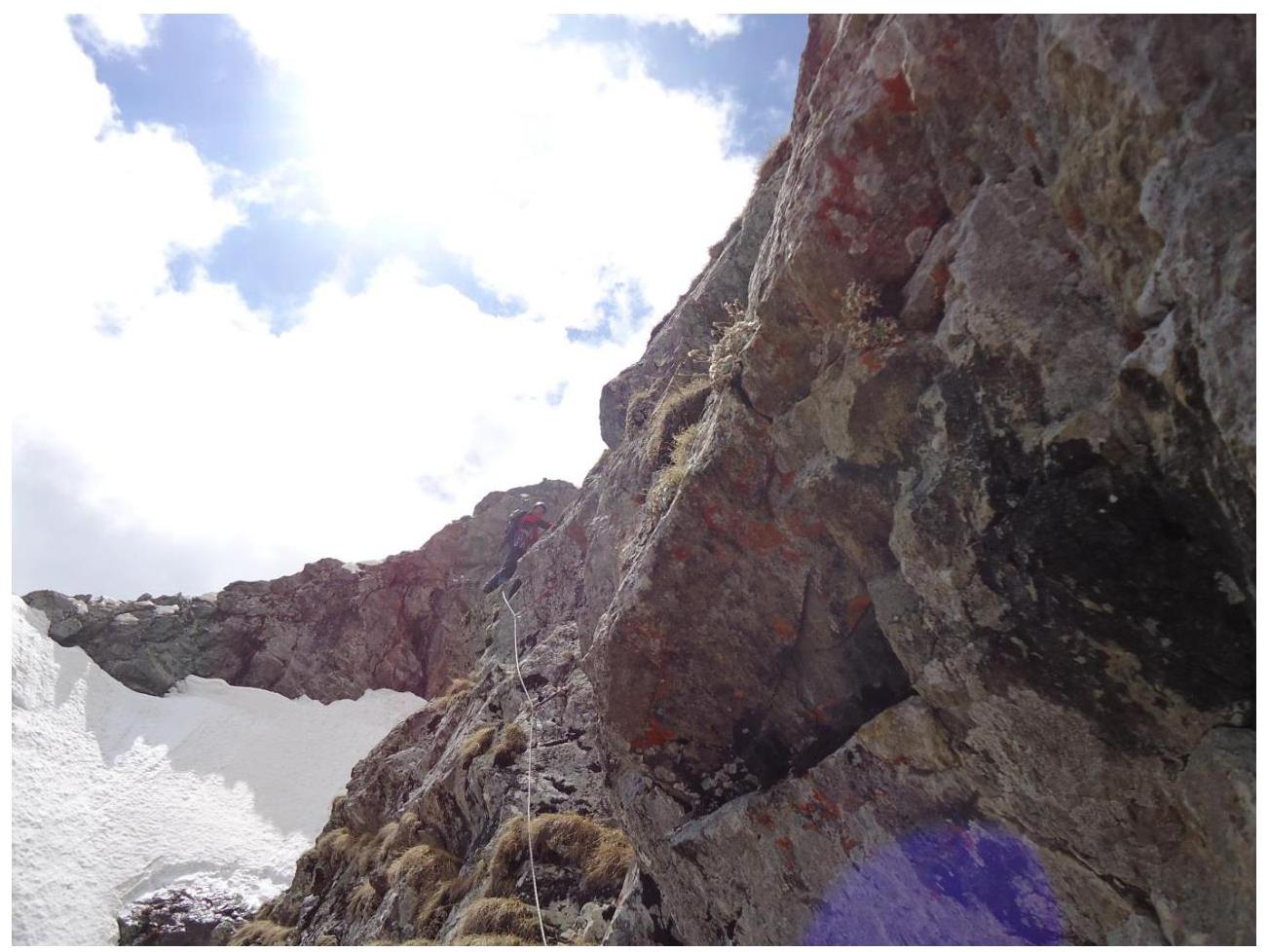
Section R1–R2 — bypassing the first wall of the North Edge (Photograph No. 5) is carried out along the snowfield on the right side (40 m, 50°, 3 cat. diff.), alternate belay. Organization of a station is possible on the rocky outcrops of the right part of the North Edge.
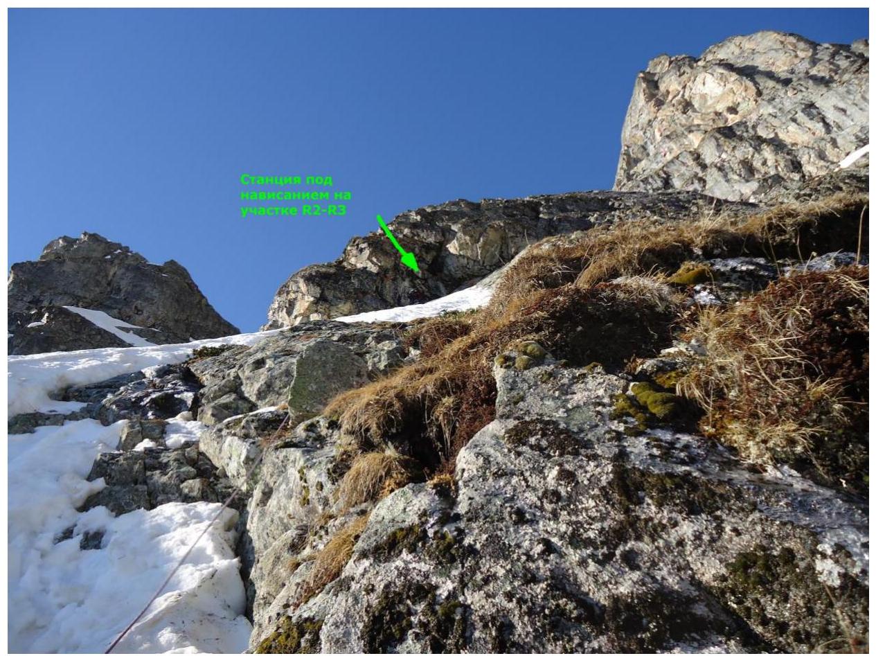
Section R2–R3 — exit to the North Edge along the snowfield (40 m, 45°, 3 cat. diff.) under the overhang from the right part of the North Edge (Photograph No. 6). Alternate movement. Station on a rocky ledge under the overhang.
Section R3–R4 — bypassing the overhang on the right (Photograph No. 7), first along the wall (10 m, 60°, 3 cat. diff.) (formation of ice crust is possible), then traverse (15 m, 0°, 4 cat. diff.) with exit to the North Edge, further along the ledge overgrown with grass (15 m, 30°, 2 cat. diff.).
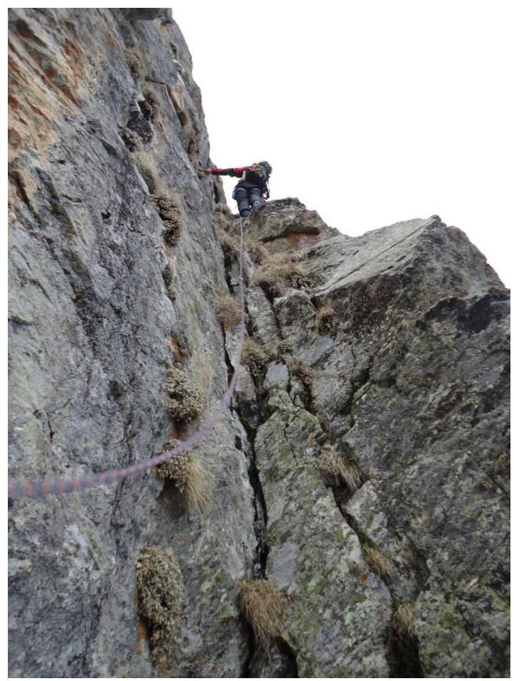
Section R4–R5 — first along the rocky ridge (10 m, 50°, 3 cat. diff., Photograph No. 8), then along the snowy ridge (30 m, 45°, 3 cat. diff., Photograph No. 9). Station on a rocky outcrop immediately after the end of the snowy ridge.
Further, the route goes along the left part of the North Edge and represents walls of various lengths and complexity, alternating with ledges overgrown with grass, which do not simplify the passage of the route. Before exiting the vertical sections onto the ledges, it is recommended to install intermediate belay points.
Section R5–R6 —
- Left along the sloping ledge (8 m, 30°, 2 cat. diff.),
- then right along the sloping ledge (8 m, 45°, 2 cat. diff.) approach under the wall,
- further along the wall (10 m, 80°, 4+ cat. diff.) exit to a ledge overgrown with grass.
Left along the ledge (8 m, 30°, 2 cat. diff.) approach under the internal corner.
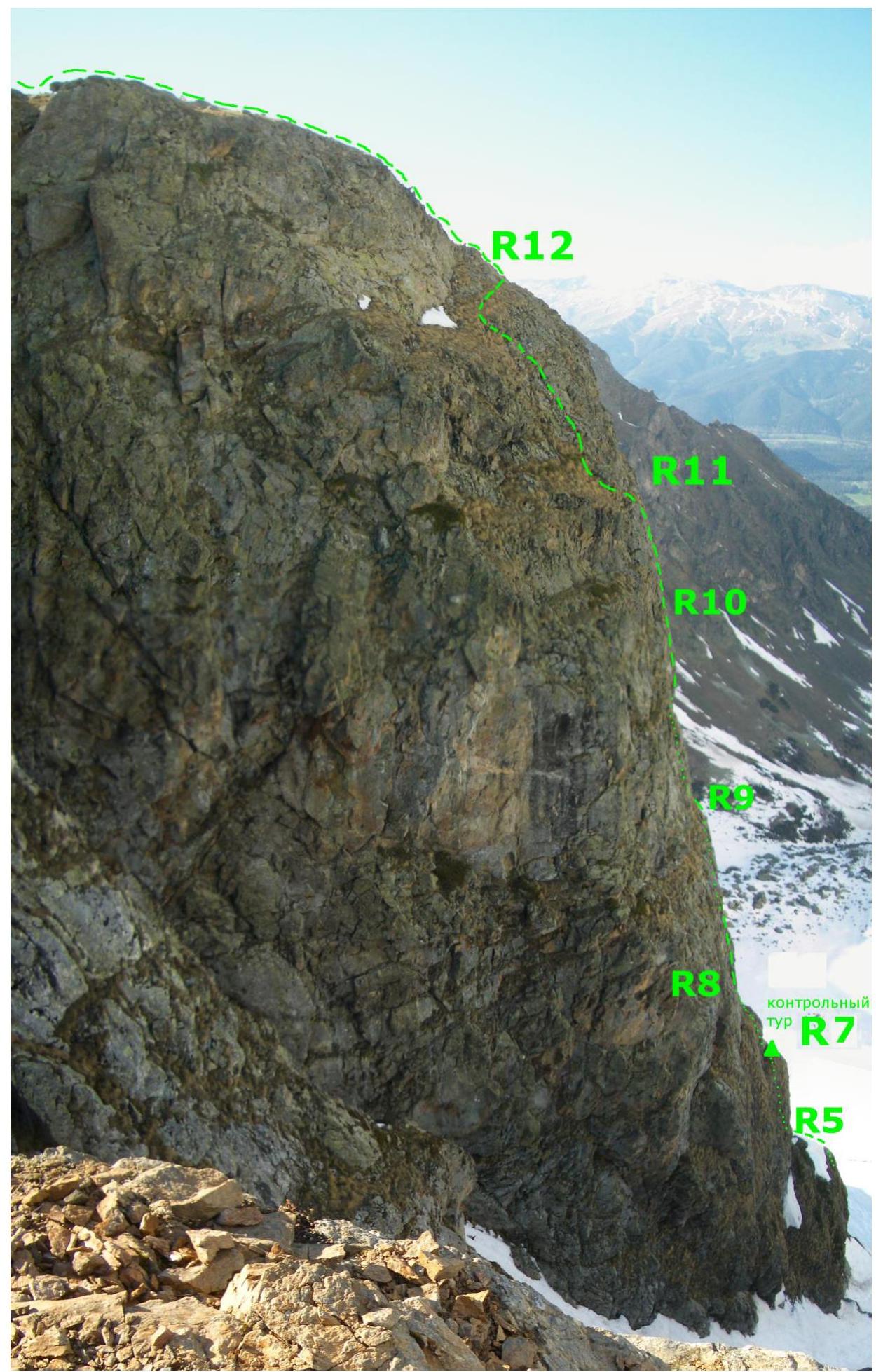
Section R6–R7 — along the internal corner (8 m, 70°, 4 cat. diff., Photograph No. 10) left exit to the wall (3 m, 60°, 3 cat. diff.), then left along the ledge overgrown with grass (20 m, 30°, 2 cat. diff.) to a large stone under the cornice. Control tour on the stone (Photograph No. 11).
Section R7–R8 — along the internal corner (10 m, 70°, 4 cat. diff., Photograph No. 12), going left, exit to the wall (20 m, 60°, 3 cat. diff.), further to a ledge overgrown with grass (2 m, 30°, 2 cat. diff.). Along the ledge, approach under the vertical internal corner.
Section R8–R9 — along the right side of the internal corner (15 m, 80°, 5 cat. diff., Photograph No. 13) exit to a ledge overgrown with grass (5 m, 0°, 2 cat. diff.), along the ledge approach under the internal corner with an overhang.
Section R9–R10 — key section. Along the internal corner (12 m, 90°, 5+ cat. diff., Photograph No. 14) exit left to the wall (20 m, 80°, 5 cat. diff.), and then to a ledge overgrown with grass (1 m, 30°, 2 cat. diff.).
Section R10–R11 — along the wall (20 m, 80°, 4 cat. diff., Photograph No. 15) exit to a sloping ledge overgrown with grass.
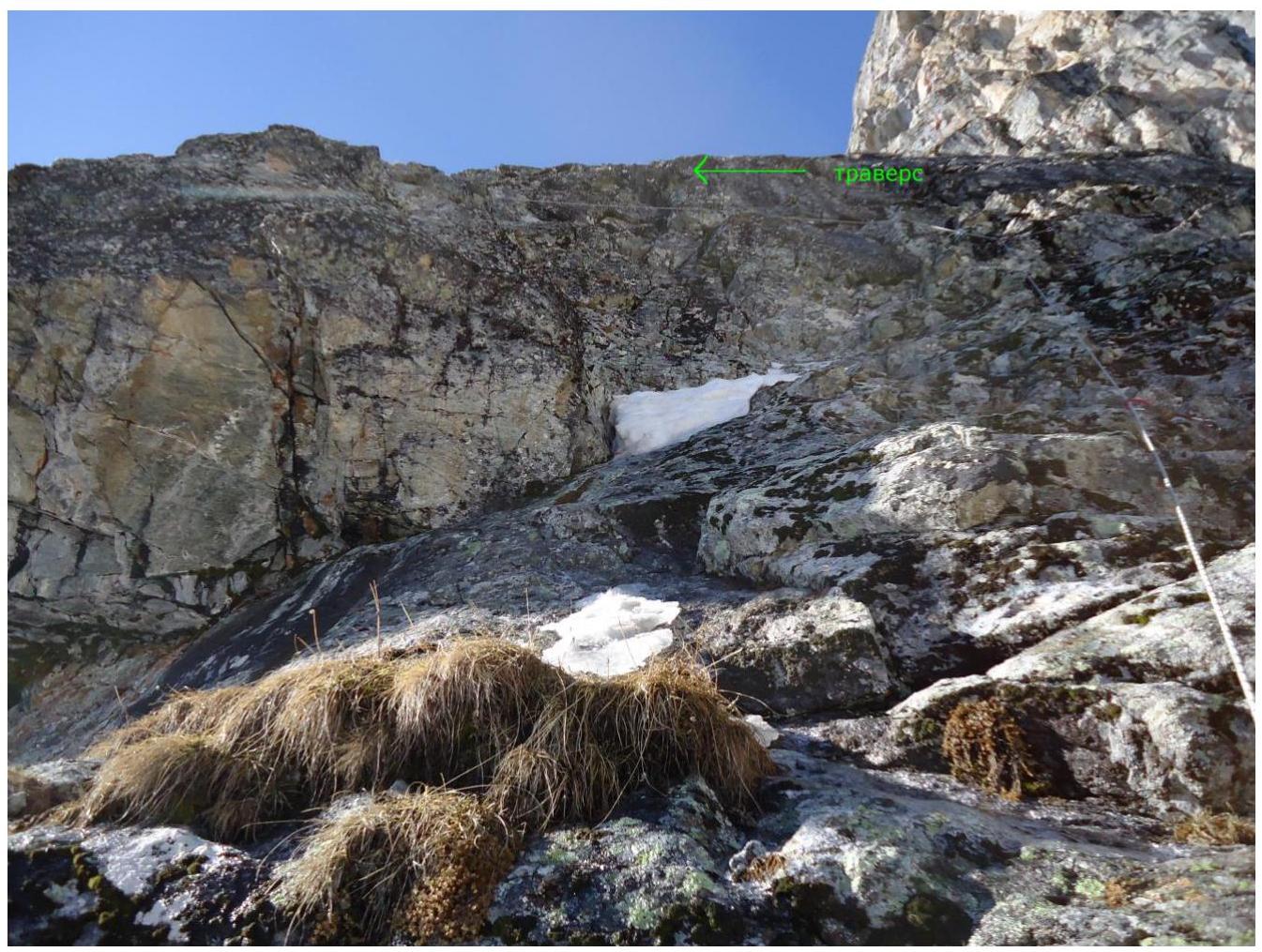
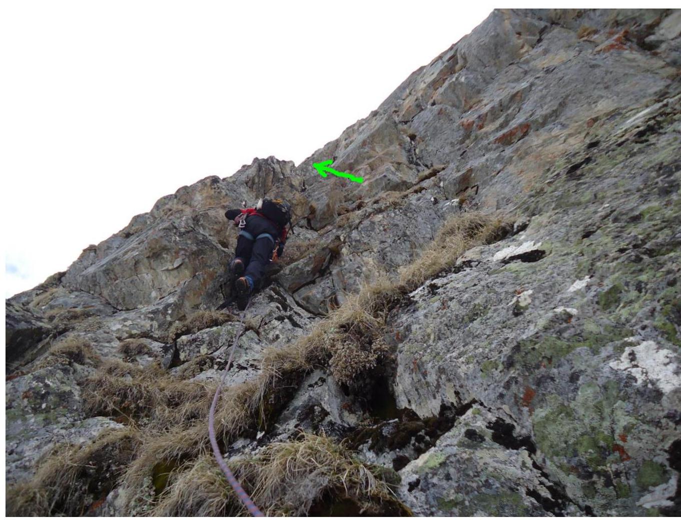
Section R11–R12 — left along the ledge (20 m, 30°, 2 cat. diff., Photograph No. 16), then along the wall (10 m, 45°, 3 cat. diff.) and right along the ledge (20 m, 30°, 2 cat. diff., Photograph No. 17) exit to the pre-summit ridge.
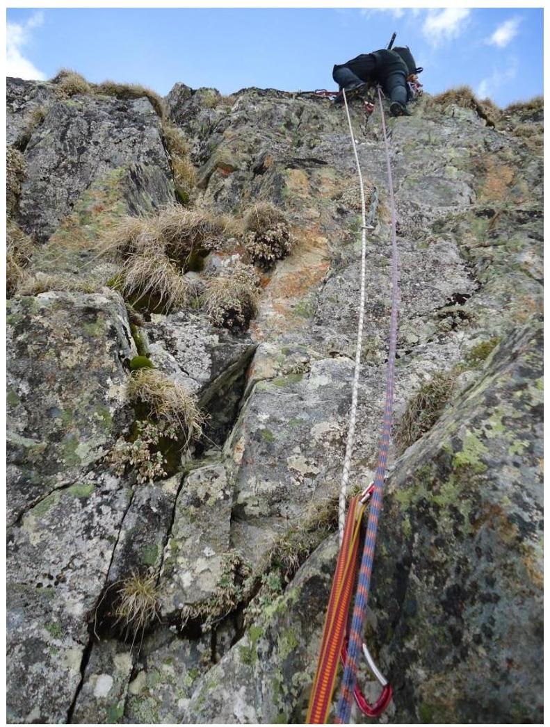
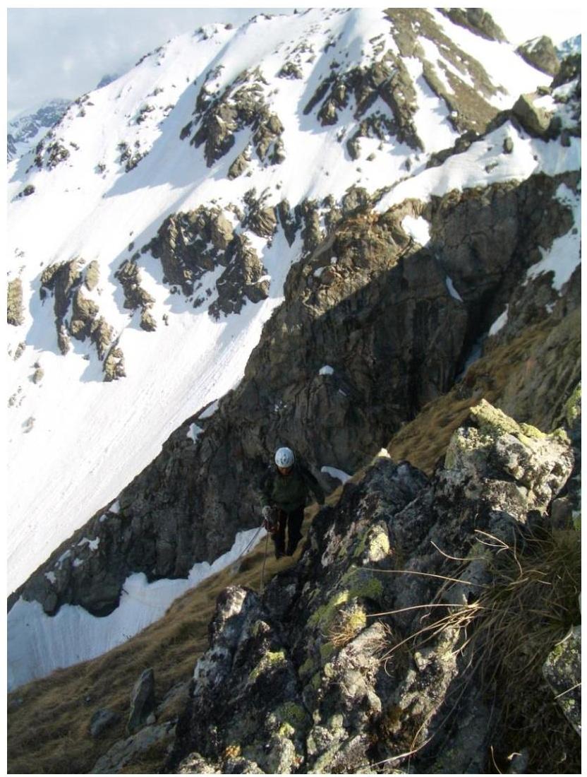
Section R12–R13 — along the destroyed ridge first 20 m, 30°, 2 cat. diff. (Photograph No. 18), then 120 m, 0°, 1 cat. diff. exit to the summit.
Descent from the summit is carried out along the couloir (1 cat. diff.), starting from the center of the horizontal section R12–R13, towards Zapyataya lake (upper) (Photograph No. 3). Simultaneous movement, in a tight group.
Recommendations for Climbers
It is necessary to start the route from the overnight stay at Zapyataya lake (lower) no later than 4:30 am, as in the end of section R0–R1 it is necessary to pass along the right part of the snowy couloir, leading to the subsummit 2970 m and ending with a snowy cornice. During the day, after the upper part of the couloir was lit by the sun, snow clumps flew through it twice.
For the ascent, it is necessary to take one pair of crampons. Depending on the state of the snow, they can be used on section R0–R2, as well as on section R2–R4, as the rocks may be covered with ice crust.
The rocks along the entire route are not destroyed, there are few "live" stones, most of the cracks are blind, anchor pitons are welcome.
Conclusion on the Preliminary Assessment of the Route
On the left side, the North Edge is bounded by a snowy couloir, which exits to the subsummit, ending with a snowy cornice. Bypassing section R1–R4 along the couloir is unsafe and more complicated. The right part of the North Edge from section R5 to R12 overhangs, taking this into account, the passed route is the most logical and safe.
Considering the experience of previous ascents of the leader on routes of 4th category of complexity:
- v. 3201 via the SSE wall — 4A cat. diff.
- v. Chegettau via the E wall of the E ridge — 4A cat. diff.
- v. Ullutau (3) via the NW wall — 4B cat. diff.
- v. Dolomity (C) via the W wall — 4B cat. diff.
- v. Dzhailyk via the W ridge — 4B cat. diff.
- v. Adyrsu South — 4B cat. diff.
- peak Ine via the NW ridge — 4A cat. diff.
- v. Belalakaya via the W edge — 4B cat. diff.
it is proposed to assign the route of the first ascent via the North Edge to summit 2970 m — 4B category of complexity. It should also be noted that the first ascent was carried out under ideal weather conditions and state of the route, as well as a relatively small amount of snow this season. The presence of snow on the ledges overgrown with grass in the upper part of the route (from section R5 to section R12) will complicate its passage.
NOTES FROM THE SUMMIT CAIRN
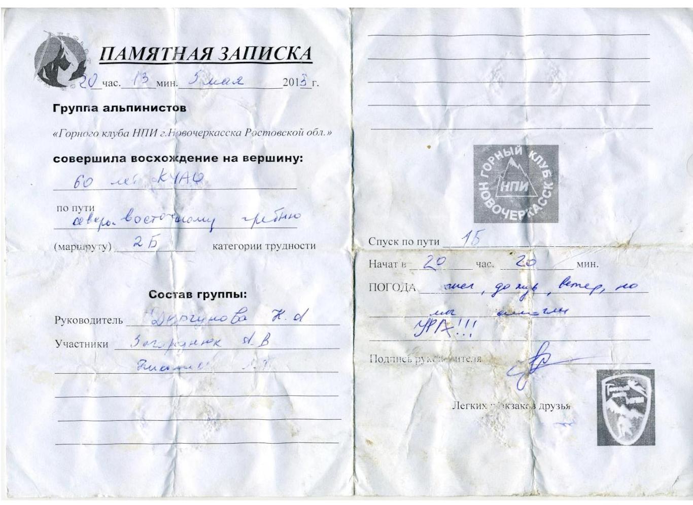
Two notes were found in the summit cairn: the first was in a jar:
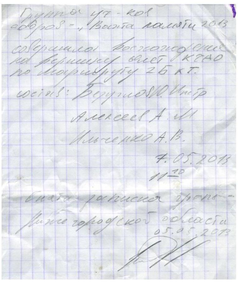
The second — just under the stone of the cairn:
Photograph No. 5. Bypassing the wall of the North Edge on section R1–R2.
Photograph No. 6. Passage of section R2–R3.
Photograph No. 7. Passage of section R3–R4.

Photograph No. 8. Passage of section R4–R5 (rocky ridge).
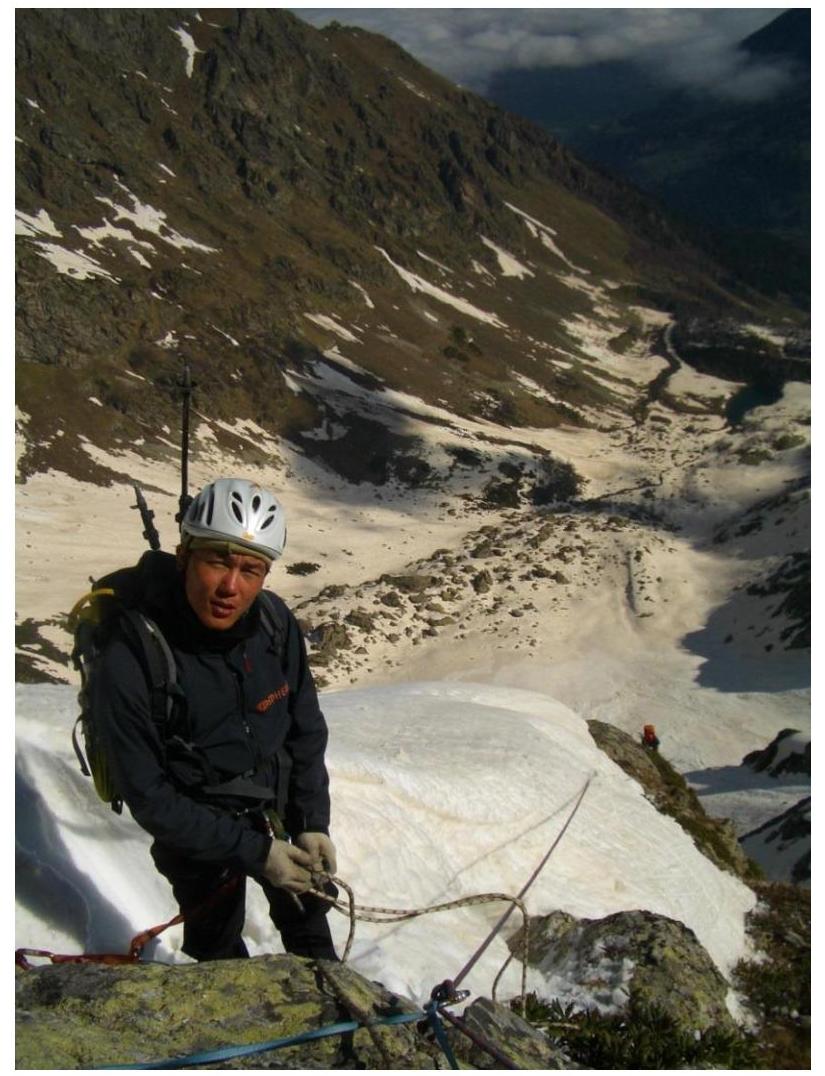
Photograph No. 9. Zhambalov Sergey after passing section R4–R5 (snowy ridge).
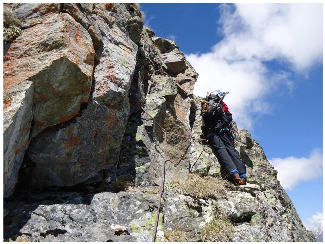
Photograph No. 10. Passage of section R6–R7 (internal corner).
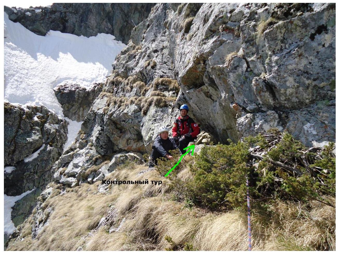
Photograph No. 11. After passing section R6–R7 at the control tour.
Photograph No. 12. Exit to the wall along the internal corner on section R7–R8.
Photograph No. 13. Passage of the internal corner on section R8–R9.
Photograph No. 14. Passage of the internal corner on section R9–R10 (key section).
Photograph No. 15. Passage of the wall on section R10–R11.
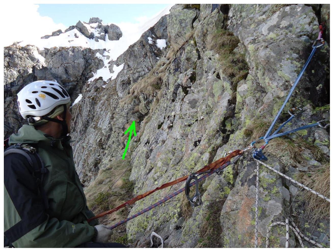
Photograph No. 16. Ledge going left on section R11–R12.
Photograph No. 17. Exit to the pre-summit ridge on section R11–R12.
Photograph No. 18. Start of section R12–R13.
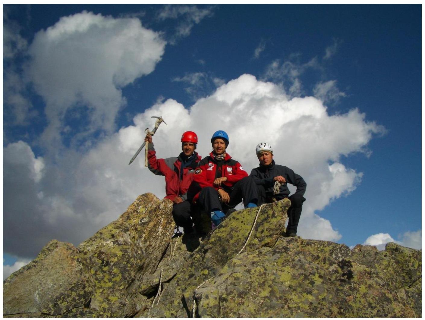
Photograph No. 19. Group of first ascenders on summit 2970 m (60 years of KChAO). From left to right:
- Mikhail Zhamgochyan
- Evgeny Iver
- Sergey Zhambalov
Comments
Sign in to leave a comment