Ascent Passport
-
Ascent Class
- technical
-
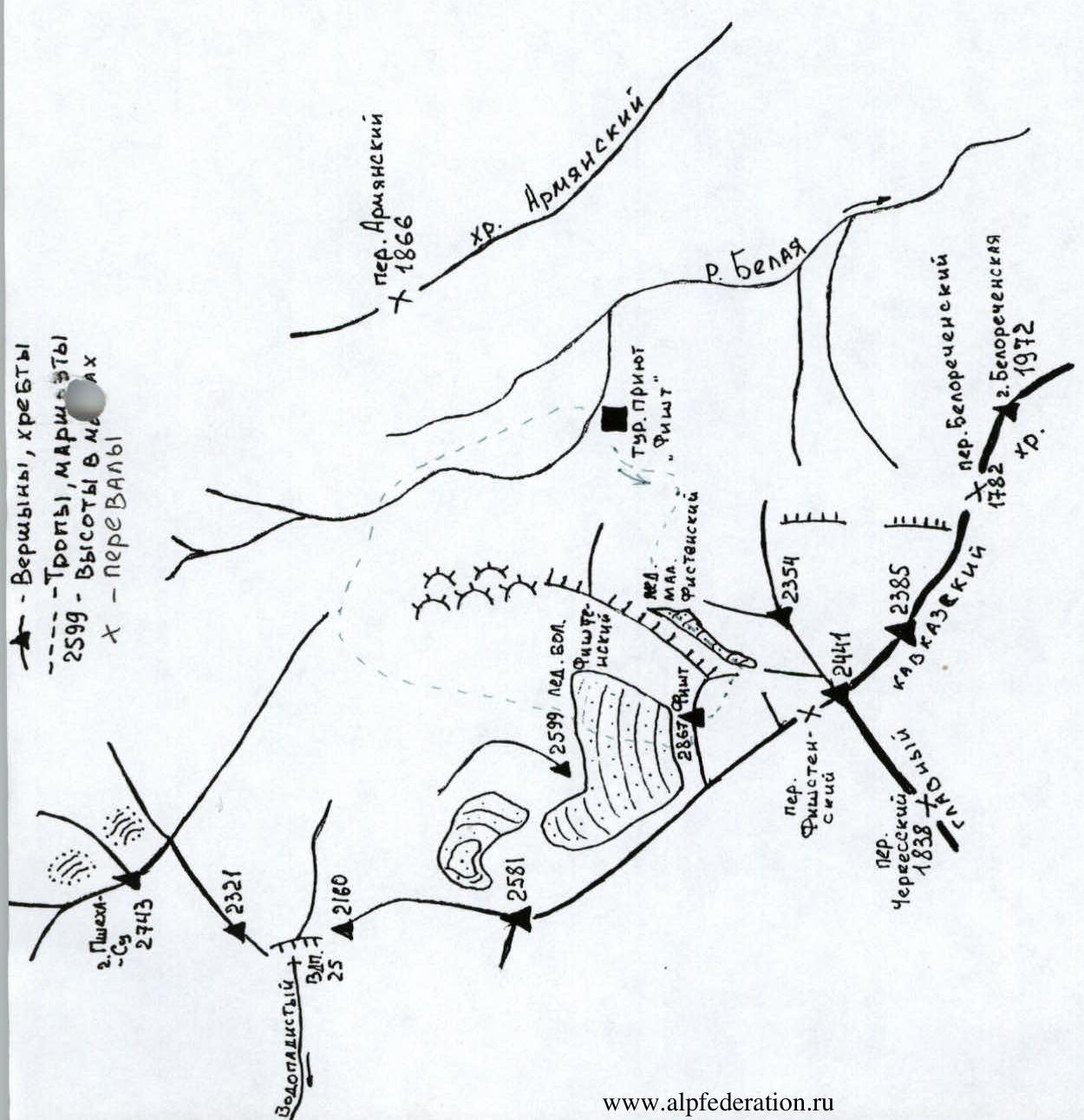
Ascent Area: Western Caucasus, Main Caucasian Range, Belaya River valley
-
Peak, Route: p. Fisht (2867 m), via SE wall
-
Expected category of difficulty — 4A, first ascent
-
Height difference:
- 767 m
- of which the actual wall section — 310 m
- total route length — 1000 m
- wall section length — 400 m
- average steepness of the wall section — 56°
- average steepness of the route — 51°
-
Pitons driven:
| Rock | Ice | Nuts | Bolts |
|---|---|---|---|
| 14 | 0 | 35 | 0 |
| 0 | 0 | 0 | 0 for aid climbing |
- Movement hours/days — 12/0.5
- Leader Foigel Maxim Rafailovich — II sports category
Team Members:
- Rudenko Nikolai Nikolaevich — II sports category
- Aliev Rinat Kharisovich — II sports category
- Kulinskiy Yakov Aleksandrovich — I sports category
- Kozorezov Evgeniy Vladimirovich — II sports category
- Approach to the route — May 8, 2001 Summit — May 8, 2001 Return — May 8, 2001
Date taken: May 8, 2001
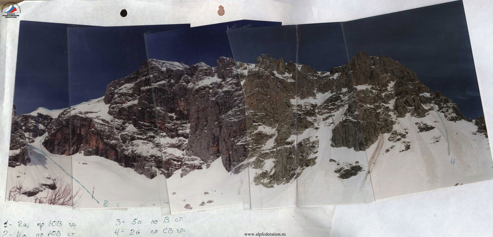
- 1–2A via SE ridge
- 2–4B via SE wall
- 3–5A via E wall
- 4–2B via NE ridge
- p. Fisht 2867 m

Brief Description of the Approach
From the base camp located at the "Fisht" tourist shelter:
- Ascend via the marked trail leading to Belorechensky Pass.
- Upon exiting the forest zone, turn right along the stream flowing from the Maly Fishtinsky Glacier.
- Under the glacier tongue, turn left towards the Southeast walls of Fisht Peak.
- Then proceed along the Maly Fishtinsky Glacier to the bergschrund under the SE wall.
From "Fisht" tourist shelter — 2–3 hours.
Brief Geographical and Sporting Characteristics of the Ascent Object
The Fisht-Osthen massif marks the beginning of the Greater Caucasus. It is formed by three main peaks in the area:
- Fisht
- Osthen
- Pshekha-Su
Fisht (2867 m), Osthen (2804 m), and Pshekha-Su (2744 m). The slopes of Fisht also feature the westernmost glaciers in the Caucasus. These glaciers, like the massif itself, are remarkable. The Maly glacier descends to an elevation of 2150 m, despite Fisht being located 45 km from the warm Black Sea coast. The proximity to the sea and favorable winds cause a significant lowering of the snow line, contributing to the accumulation of snow masses.
The geology of the Fisht-Osthen massif is interesting because, within a small area, one can find rocks from three structural geological stages:
- Paleozoic gneisses and granites
- Lower Jurassic black clay shales
- Upper Jurassic limestones
Fisht is a museum of karst formations; its southern wall features the entrance to the famous "Soaring Bird" cave (the third deepest in the CIS — 517 m).
The Fisht-Osthen massif is a vast natural reservoir of fresh water. The rivers of the Northwest Caucasus — Belaya and Pshekha — originate here, and the water reserves of the massif also feed the rivers of the southern macroslope of the Main Caucasian Range — Ashe, Psezuapse, Shakhe, Sochi.
For mountaineering ascents, Fisht is particularly interesting along with a group of peaks without names within the Main Caucasian Range. Various difficulty categories of mountaineering routes have already been laid out on Fisht, including 5A. The southern slopes of Fisht remain unexplored, although they feature interesting walls and counterforts.
One can get here:
- from Maikop by bus to Guzeripl settlement — 95 km, then on foot 32 km to "Fisht" tourist shelter or by car to "Lagoonaki" ski base, then on foot 30 km to "Fisht" tourist shelter.
- from Daghomys settlement by bus to Solokh-aul settlement, then on foot through Babuk-aul settlement — 30 km to "Fisht" tourist shelter.
Route Description by Sections
A distinctive feature of the route is that it is logical and safe. It is practically impossible to deviate from the route because to the right of the route line, there are numerous overhangs and cornices, and to the left, there are unreliable "live" rocks with scree shelves. Almost all belay stations are located under overhangs, providing significant protection from rocks thrown from above. The upper part of the route is simple and safe — it follows a ridge and a couloir.
R0–R1: Cross the bergschrund and ascend upwards to the right under a large rusty overhang at the base of the SE wall (rocks, avalanches!). The belay station is located more to the right on a shelf.
R1–R2: A wide internal angle leading under an overhanging rock belt.
R2–R3: Along a shelf to the left, then upwards; steep sections are bypassed via shelves. Further — an internal angle, leading under a black overhang.
R3–R4: Along a shelf to the left under a wide internal angle with a cleft, then up the cleft to a shelf.
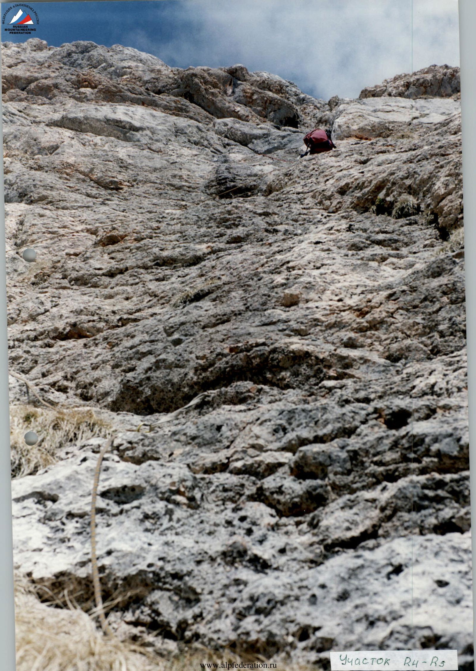
R4–R5: Upwards along a not-too-steep wall to a gentle internal angle. Along the angle to the right, then along the wall, exiting onto grassy shelves with rocks ("live rocks") under an overhanging wall. Left of the rusty internal angle.
R5–R6: Straight up along steep overhanging rocks to a shelf under the base of a wide chimney. Belaying is challenging; "live" rocks.
R6–R7: A wide chimney. The start is overhanging. It is more convenient to lift the first climber. Along the left wall of the chimney to a shelf with a grotto under an overhang. It is possible to organize a bivouac. Control cairn.
R7–R8: To the right, bypassing the overhang. Then — upwards to the left along a system of shelves and small walls — exiting under overhanging light-colored rocks.
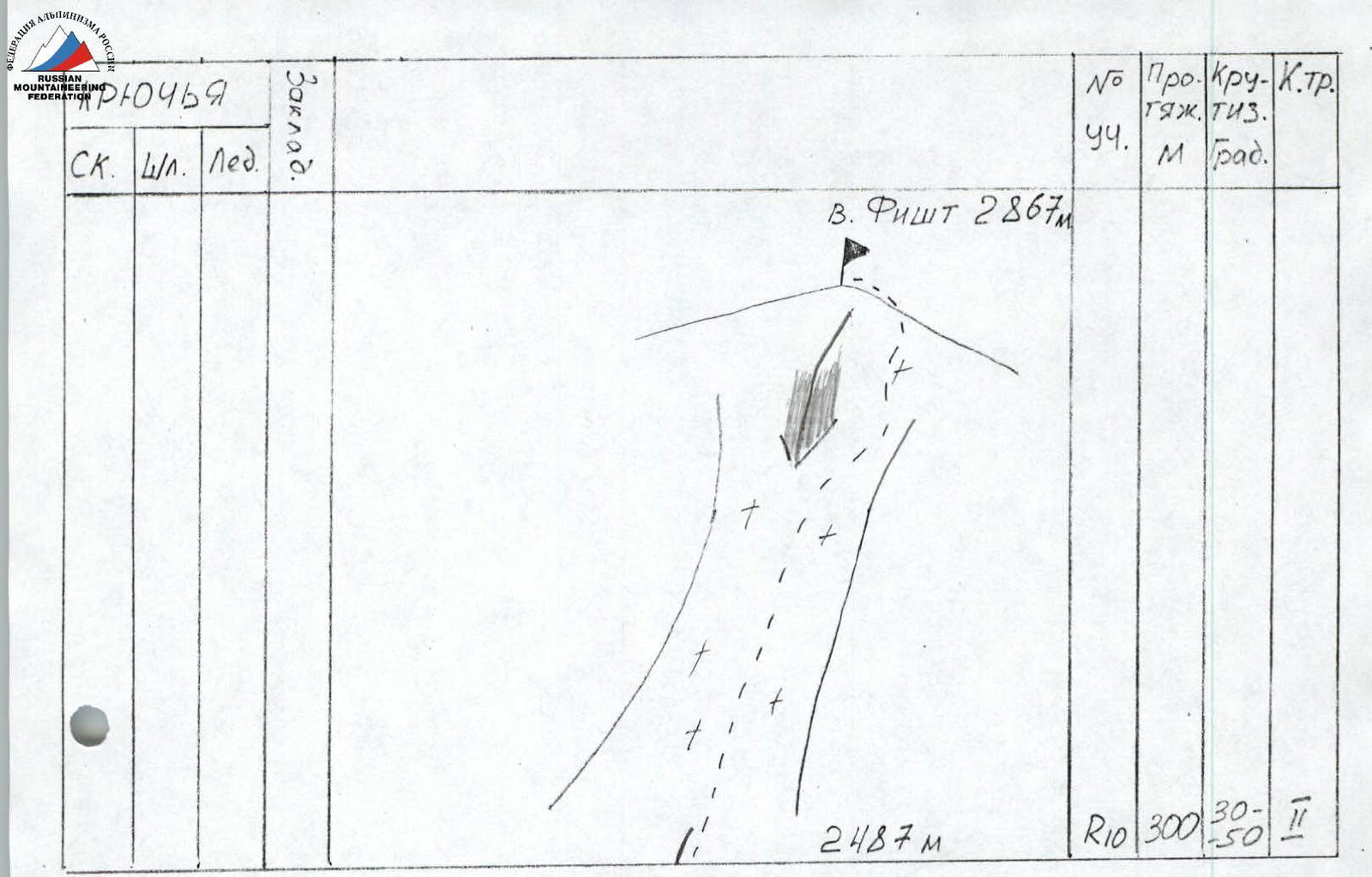
R8–R9: Along a shelf to the left around a bend. Exiting onto a snow-rock ridge.
R9–R10: A simple snow-rock ridge.
R10–R11: A wide couloir, along it to the point where the couloir forks. Along the right path — onto the ridge. Along the ridge — to the summit.
Route Diagram in UIAA Symbols
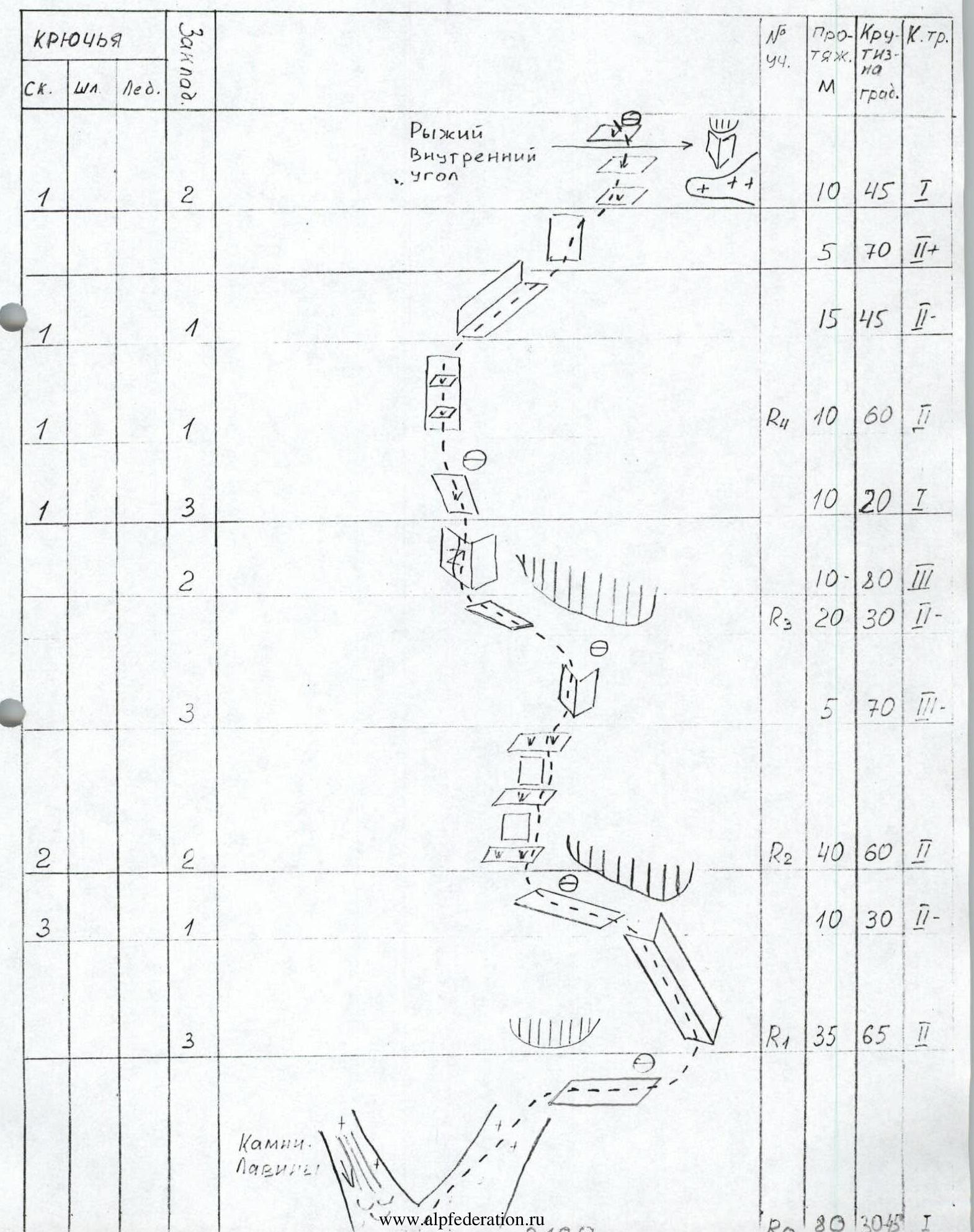
Brief Explanation of the Table
The entire route can be divided into two large sections:
- 1st: wall, length 400 m, average steepness 56°.
- 2nd: ridge and couloir, length 600 m, average steepness 33°.
There is one control cairn on the route — on a clearing with a grotto (section R7).
Time taken to pass the sections:
- R1–R9 (400 m) — 6 hours — wall
- R9–R11 (600 m) — 1.5 hours — ridge, couloir
Possible bivouac locations:
- On a shelf with a grotto (section R7, water in the form of névé).
General Conclusion on the Route
The route on p. Fisht via the SE wall is an interesting rock climbing route. It is logical and safe. Rocks and snow fall to the right. Belay stations are located under overhangs.
The wall section of the route features the most diverse forms of rock relief. Belay stations are convenient and safe.
The route will be significantly complicated in case of bad weather and low temperatures due to a large amount of remnant ice on the wall section.
When evaluating the route, the group compared it to the following previously climbed routes:
- Belalakaya from the north — 3B category of difficulty
- Dombai Main — 3B category of difficulty
- Latsga via S ridge — 3B category of difficulty
- Inya Peak via NW ridge — 4A category of difficulty
- Dombai Maly from Chuchkhur Pass — 4A category of difficulty
- Latsga via SE couloir — 4B category of difficulty
The group believes that in terms of complexity, section length, and overall, the route exceeds the above-mentioned 3B category routes by half a category and is not inferior to 4B, 4A category routes.
The route can be recommended as interesting and sufficiently challenging for sport ascents.
Based on the above, the group considers that the route on p. Fisht can be rated as a 4A category route.
Team Captain Foigel M.R.
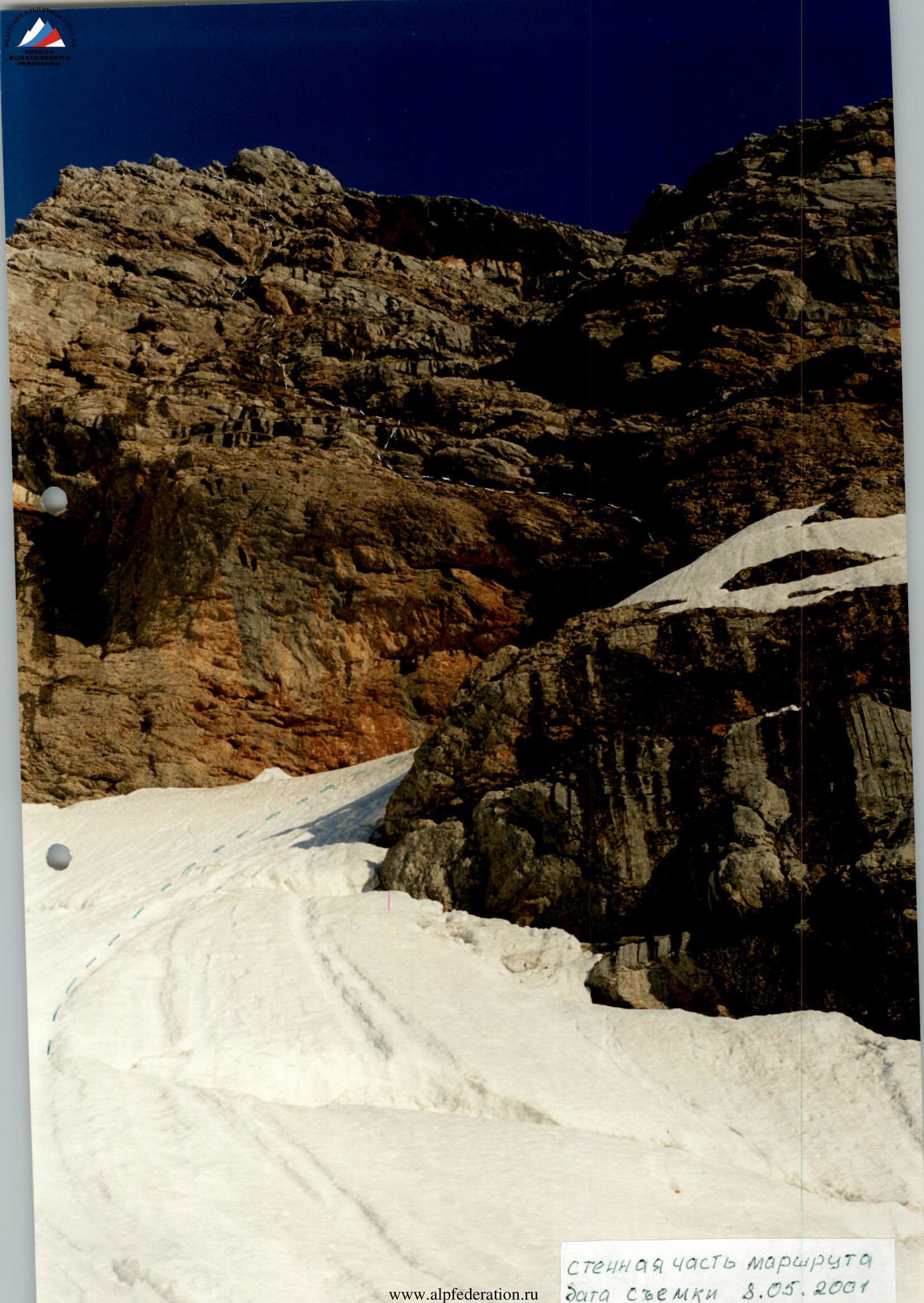
Wall section of the route. Date taken: May 8, 2001
Wall section of the route. Date taken: May 8, 2001
Section R4–R3