| I. Category of ascent | — technical |
| 2. Area of ascent | — Western Caucasus, Krasnodar Krai up to Marukh pass |
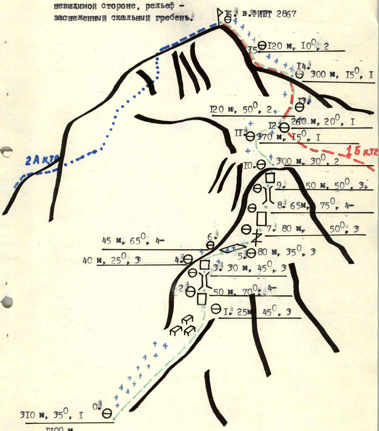
| 3. Peak, its height and ascent route | — Mt. Fisht, 2867 m, via north-eastern ridge |
| 4. Proposed complexity category | 2B |
| 5. Route characteristics: | |
| a). height difference | 1167 m |
| b). average steepness | 50° (excluding sections on snow plateau) |
| c). length of sections | — I — 240 m; II — 540 m; III — 305 m; IV — 160 m |
| 6. Pitons driven: | |
| for belay | for creating RPS |
| rock | 27 |
| ice | – |
| bolt | – |
| chocks | 16 |
| 7. Number of climbing hours | 9 h |
| 8. Number of overnight stays and their characteristics | – |
| 9. Group composition: | |
| 1. Noskov Alexey Mikhailovich | 1st sports category — leader |
| 2. Yarmolinsky Sergey Alexandrovich | — 2nd sports category |
| 3. Cherepanov Valery Sergeevich | — 2nd sports category |
| 4. Sergienko Vladimir Ivanovich | — 2nd sports category |
| 10. Team coach | — Pogosyan Fedor Liparitovich MS USSR |
| 11. Date of departure on the route | — May 4, 1985 |
| 12. Date of return | — May 4, 1985 |
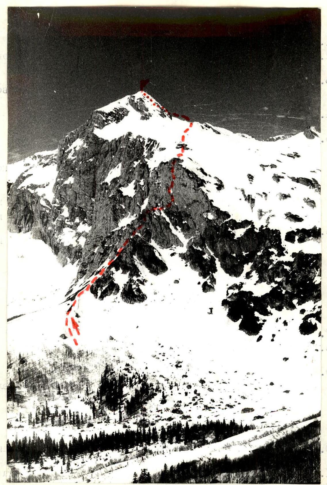
Peak 2867 "Fisht". Photographed on 05.05.1984 from "Armenian" pass, height 1809 m from a distance of about 4 km with "Industar 61 L/3" lens. Height of "Fisht" peak 2867 m.
Map-diagram of the ascent area
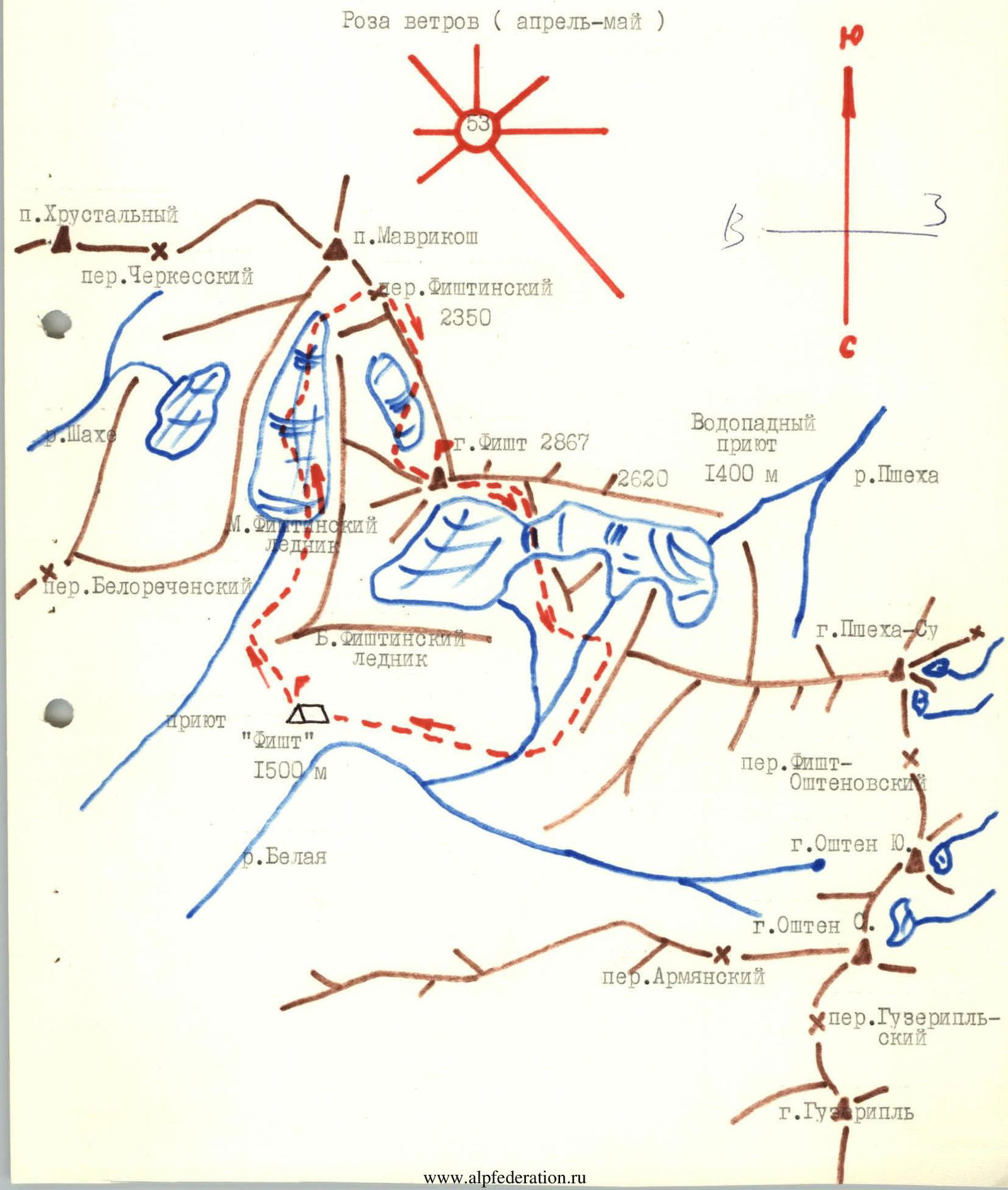
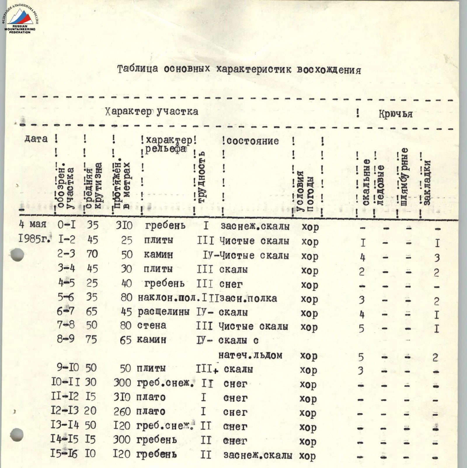
Table of main ascent characteristics
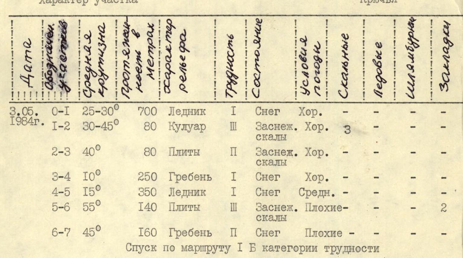
| Date | Section | Average steepness | Length in meters | Terrain characteristics | Cat. diff. | Condition | Weather conditions | Rock pitons | Ice pitons | Bolt pitons | Chocks |
|---|---|---|---|---|---|---|---|---|---|---|---|
| May 3, 1984 | R0–R1 | 25–30° | 700 m | Glacier | 1 | Snow | Good | – | – | – | – |
| R1–R2 | 30–45° | 80 m | Couloir / rocks | 3 | Snow-covered | Good | 3 | – | – | 1 | |
| R2–R3 | 40° | 80 m | Slabs / rocks | 2 | Snow-covered | Good | – | – | – | – | |
| R3–R4 | 10° | 250 m | Ridge | 1 | Snow | Good | – | – | – | – | |
| R4–R5 | 15° | 350 m | Glacier | 1 | Snow | Average | – | – | – | – | |
| R5–R6 | 55° | 140 m | Slabs / rocks | 3 | Snow-covered | Bad | – | – | – | 2 | |
| R6–R7 | 45° | 160 m | Ridge | 2 | Snow | Bad | – | – | – | – | |
| Descent via 1B category difficulty route. |
Brief description of the approach to the route
From Guzeripl settlement to Armenian shelter along the road — 27 km.
From Armenian shelter along the trail, following the rocks of the North-Eastern ridge of Mt. Oshen, to Guzeriplsky pass — 2.5–3 h.
Further from Guzeriplsky pass to Armenian pass — 1 h.
Descent from Armenian pass to Fisht shelter — 0.5–1 h.
From the shelter, the path to the route lies straight up towards the Small Fishtinsky glacier. At the exit from the forest zone — turn towards the South wall of Mt. Fisht. Further — to the base of the North-Eastern ridge in its right part.
Descent via 1B category difficulty route.
Attention! On section R14–R15, there are large cornices!
Section R15–R16 passes along the invisible side, terrain — snow-covered rocky ridge.