Ascent Passport
- Class: rock
- Western Caucasus, Arkhyz, Pshysh River valley.
- Tokmak (3438 m). Via the South slope and South wall
- Proposed 4A category difficulty, first ascent
- Height difference: 1318 m. Rock part 390 m.
Length of sections with 5–6 category difficulty: 40 m. Average steepness of the key part of the route is 80–85°. Overall route steepness is 35–45°. Total route length (rock part) is 1075 m.
- Pitons left on the route: rock 6 pieces.
- Team's climbing hours: nine up, five down.
- Leader: Plotnikov Alexander Alexandrovich, 1st sports category.
- Coach: Zolotarev Igor Nikolaevich, 1st sports category, instructor 1st category.
- Departure to the route: 6:40 AM, September 11, 2001.
Reached the summit at 15:20. Returned to base camp at 20:40. Western Caucasus. Arkhyz. Map-scheme of the area, approach route, and ascent to Tokmak peak.
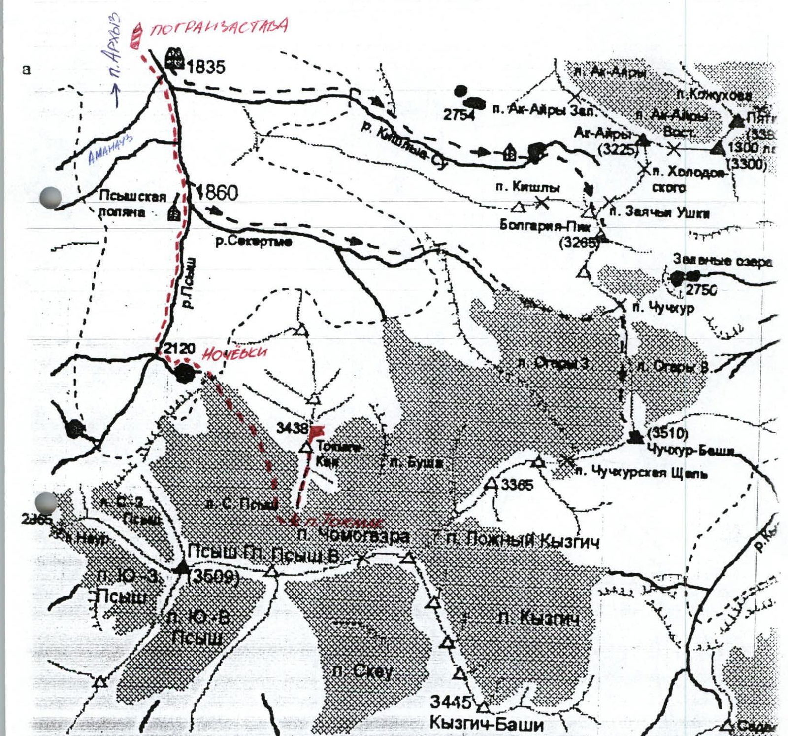
You can reach Cherkessk by bus or train. From Cherkessk, take a bus to Zelenchukskaya stanitsa. From the stanitsa, take a bus or hitch a ride to Arkhyz settlement. From Arkhyz settlement, you can reach the border outpost by car or on foot in 4–5 hours.
From the border outpost:
- Follow the trail. After large meadows, turn left and cross the Amanauz River.
- Bypass the forest zone and the confluence of the Sekertme and Pshysh rivers, and reach the green moraine on the western side of Mt. Tokmak.
- Cross the Pshysh River and ascend to the moraine near Tokmak Lake.
Overnight stops. From the outpost, 5–6 hours.
1.

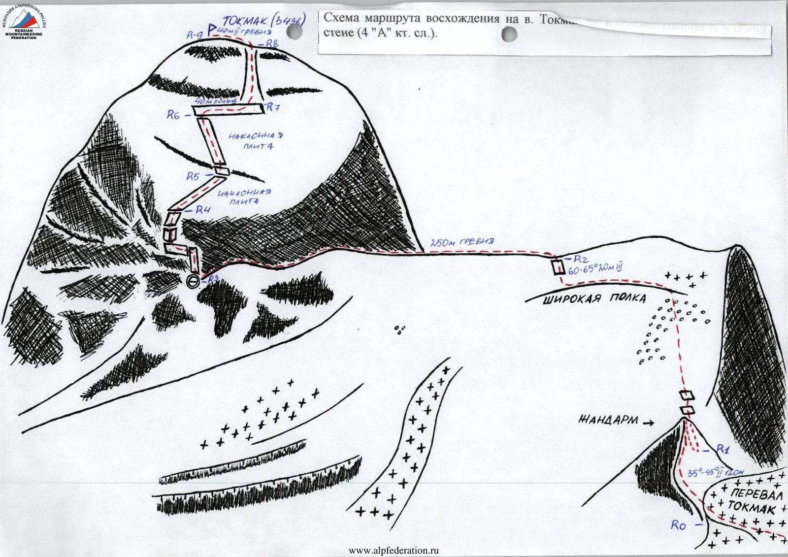
Route diagram for ascending Mt. Tokmak via the wall (4A category difficulty).
| Section № | Length in meters | Category of difficulty | Slope steepness in degrees | Height difference in meters | Time taken in minutes |
|---|---|---|---|---|---|
| R0–R1 | 120 | 2 | 35–50° | 40–45 | 30 |
| R1–R2 (including) | 430 20 | 2 3 | 30–40°, 60–65° | 190 | 50 |
| R2–R3 | 250 | 2 | ridge | 15 | 40 |
| R3–R4 | 40 | 5–6 | 80–85° | 35 | 50 |
| R4–R5 | 40 | 4 | 70–45° | 25 | 30 |
| R5–R6 | 32 | friction | 35° | 10–15 | 20 |
| R6–R7 | 40 | 1–2 ledge | 0° | 40 | 15 |
| R7–R8 | 45 | 2 couloir | 45° | 30–35 | 20 |
| R8–R9 | 40 | 2 ridge | 5–6° | 5 | 15 |
Route diagram for ascending from the saddle to the summit (Tower).
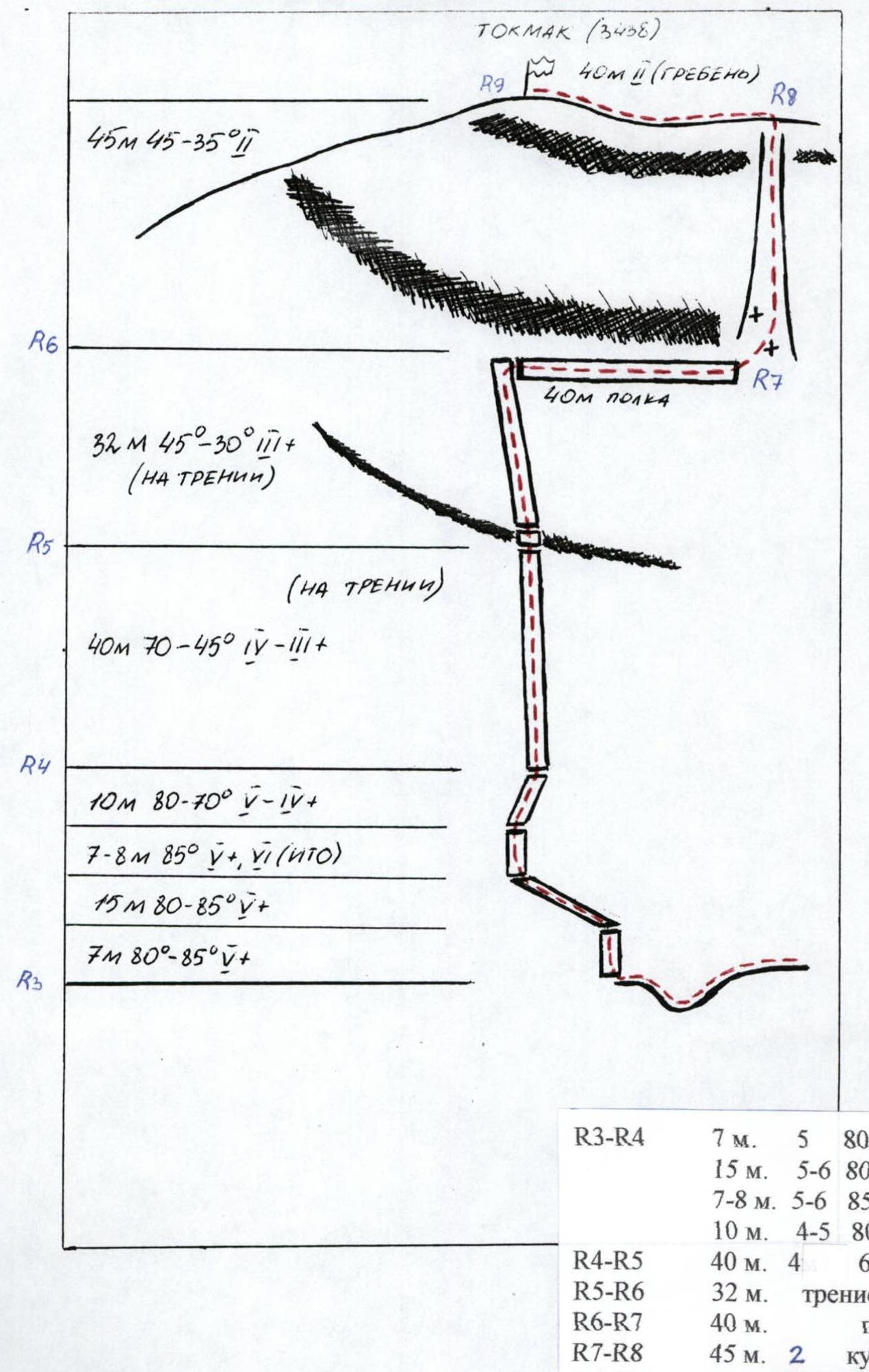
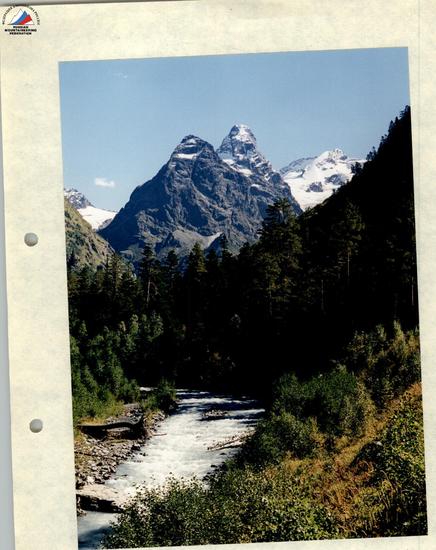
Photo №16. Tokmak peak. View from the Pshysh valley. North aspect. To the right is the peak V. Pshysh. Photo by Plotnikov A. (Praktica LTL –3. Pentacon 1.8/50 46°).
Report on the first ascent of Mt. Tokmak (3438 m) via the South ridge and South wall (4A category difficulty.)
September 11, 2001. SGKP "Skif" Stavropol. Leader: Plotnikov A.A. (1st sports category) Parutin I.O. (1st sports category) Kolokolnikov K.V. (2nd sports category) Katsak D.V. (2nd sports category)
From the overnight camp by the lake (elevation 2120 m), follow the left-bank moraine (in the direction of travel), keeping to the edge of the rocks or directly into the face to reach the S. Pshysh glacier (photo №1).
Ascend the central tongue of the glacier (photo №2), slightly deviating left in the upper part, to reach a fold in the glacier between two icefalls. From the start of the glacier to the fold, use 5 ropes. Rappel. Ice screws.
Continue to the pass in simultaneous movement, linked:
- Up and right through the fold for 80–100 m to reach a flat ice field.
- From there, ascend left and upwards, keeping to the direction of the couloir on the Western wall of Mt. Tokmak, with a steep climb of 150–200 m.
- Continue to follow the left side of the glacier (photo №3), without getting too close to the wall (rocks!), to reach the Tokmak pass.
- Under the pass, bypass the icefall on the right (photo №4).
The entire route is visible from the approach to the pass (photo №5).
Time from overnight camp to Tokmak pass (elevation 3050 m, 2A category difficulty): 4 hours. Ascent: 930 m.
Section R0–R1. From Tokmak pass, ascend directly through a gendarme for about 120 m (photo №7). Reach the saddle between the gendarme and the slope of the South ridge.
Climbing is moderately difficult, with short, quite steep sections. Insurance via outcrops. Alternating movement.
- Height difference from Tokmak pass (3050 m) to the gendarme saddle: 40–50 m.
- Time taken: 30 minutes.
Section R1–R2 (photo №6). From the saddle, two steep walls (70–80°) of 6–7 m are climbed using cracks. Climbing is average (III+).
After the walls:
- Ascend 300 m along a broad scree slope, slightly deviating left;
- Reach a wide (5–10 m) ledge;
- Turn left and proceed for about 100 m.
From there:
- Move directly upwards towards a clear depression in the ridge;
- After 40 m, a wall (photo №8);
- Climb the wall's diagonal ledges (III–IV) for 15–20 m to reach the ridge.
Climbing features:
- Alternating movement;
- Insurance on the final section.
Section characteristics:
- Height difference from the saddle to the ridge: 190 m;
- Time taken: 50 minutes.
Section R2–R3 (photo №5). Follow the ridge (250 m) to reach the South wall (photo №9). The ridge is heavily broken. Simultaneous movement. Insurance via outcrops.
Height difference: 15 m. Time taken: 40 minutes.
Section R3–R4 (photo №9). From the saddle, climb directly up the wall – difficult climbing 4–5 m – piton (photo №10). From the piton, 3–4 m upwards to a poorly defined ledge, obliquely left and limited by a sheer wall below (photo №11). 2–3 m along the ledge. Piton. Continue along the ledge. Climbing is difficult, on balance (category difficulty 5B). Feet stand well. Handholds are scarce. After 5–6 m, a piton. Move further along the ledge 6 m to the next piton. From there, climb directly up a poorly defined inner corner – very difficult (category difficulty 5B–6A) climbing 8 m. Possibly use artificial aids. The wall then becomes less steep, and relief appears. Continue climbing. After 10 m of difficult climbing, a station. Height difference: 35 m. Time taken: 50 minutes.
Section R4–R5. Follow the watercourse to reach a sloping, smooth slab (60–45°), lacking relief (photo №12). Climbing on friction. Reach a two-meter wall, with a good crack at its base for a station. Station on a block. Height difference: 25 m. Time taken: 30 minutes.
Section R5–R6. Ascend a two-meter wall via a diagonal ledge to the right. Then directly upwards along a similar slab (45–35), lacking relief, 30 m to an overhanging wall, 5–6 m high. Station on a large stone block.
- Height difference: 10–15 m
- Time taken: 30 minutes
Section R6–R7. Along the wall to the right on an inclined ledge 40 m to a heavily broken, poorly defined couloir, leading upwards. Simultaneous movement. Time taken: 15 minutes.
Section R7–R8 (photo №13). Up the couloir 40 m, exiting onto the pre-summit ridge.
- Height difference: 30–35 m
- Time taken: 20 minutes
Section R8–R9 (photo №14). Along the ridge to the left 40 m to the summit of Tokmak. Cairn.
- Height difference: 5 m
- Time taken: 15 minutes
Ascent from the pass to the summit took 4 hours 30 minutes. Total ascent time: 9 hours. Descent followed the ascent route. Descent from the summit to the overnight camp by Tokmak Lake: 5 hours. Total time for the route and descent: 14 hours.
Possible overnight stops:
- Tokmak pass (3050 m)
- Saddle under the main wall (1 tent)
Equipment used:
- 4 pairs of crampons
- 2 ice tools
- 2 ice axes
- 5 ice screws
- 2 ropes
- rock pitons – 8 pieces
- channel bars – 5 pieces
- set of friends
- quickdraws
- 3 Jumars
- 4 rappelling devices (figure-eights)
- rock hammers
- rock shoes.
Recommendations: To enter the border zone, it is necessary:
- Obtain a permit (bring passports)
- Contact the border guard unit in Cherkessk or the commander of the border outpost in Arkhyz settlement (Alania tourist base).
The route is recommended for well-trained and cohesive groups of 4–6 people.
To climb the wall, caloshes or rock shoes are necessary. Avoid climbing in bad weather (snow, rain).
Based on experience with ascents of 4th category difficulty peaks, the leader considers:
- The key rope of the route is comparable to the last two ropes of the route 4B category difficulty on MNR Yu-3 via the South edge ("konfetka").
- The wall of Mt. Tokmak is 5–7° steeper.
- A similar steepness is found on 45° slope of v. Stal, South wall, but climbing there is easier and the wall is not as monolithic.
- Another example is 4B on v. Latsga, third rope leading to the control cairn, but it is also slightly easier.
Observation group:
- Krapivin S.V. (1st sports category),
- Zolotarev I.N. (1st sports category),
- Vdovin O.A. (2nd sports category),
- Epanechnikov A.Yu. (2nd sports category).
Team coach: Zolotarev I.N. (certificate 512)
On September 22, 2001, a group of climbers from SGKP "Skif" reached the summit of Tokmak, consisting of:
Leader Krapivin S.V., 1st sports category, instructor III category, certificate 517. Zolotarev I.N., 1st sports category, instructor III category, certificate 512. Rudeshko S.I., 2nd sports category. Nikitas S.S., 2nd sports category.
They retrieved a note from the group led by Plotnikov A.A. from the summit and rated the route as 4A category difficulty.
Chairman of the SGKP "Skif" council, V.A. Marachev

Photo №1. View from the left-bank moraine to the S.Pshysh glacier, Tokmak pass, Tokmak peak (left) and V.Pshysh peak (right). Plotnikov Alexander (Lomo-compact).
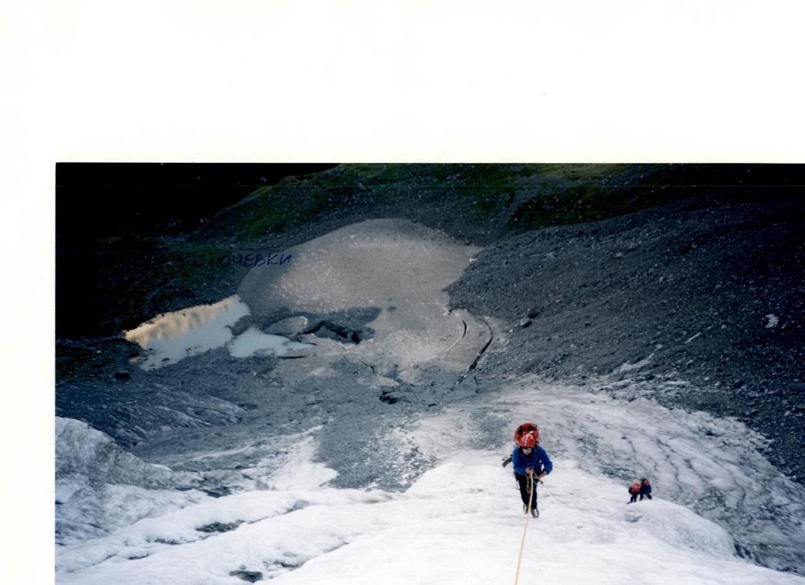
Photo №2. Central tongue of the glacier. Overnight camp by Tokmak Lake. Average steepness 35–50°. Plotnikov Alexander (Lomo-compact).
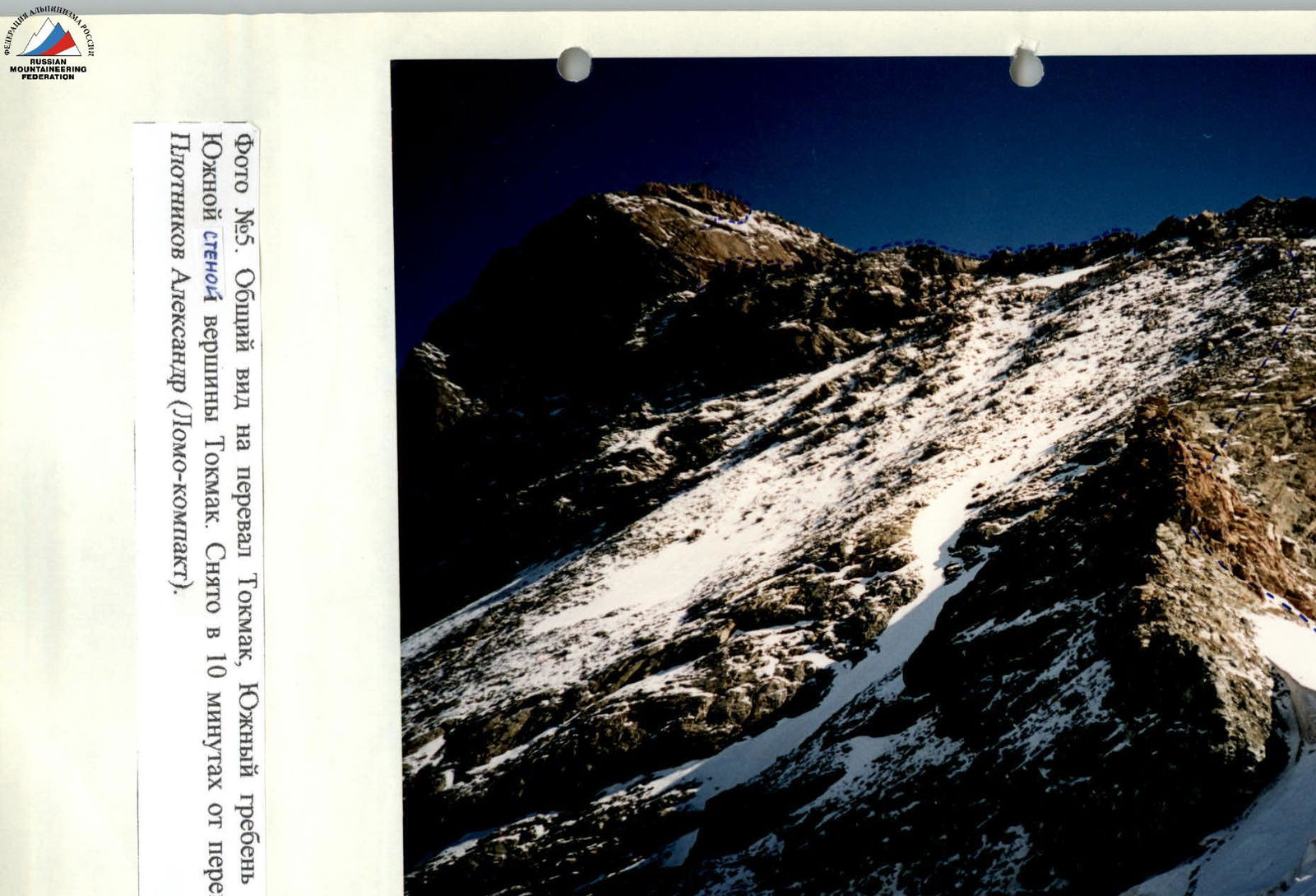
Photo №5. General view of Tokmak pass, South ridge, and tower with the South wall of Tokmak peak. Taken 10 minutes from the pass on September 11, 2001. Plotnikov Alexander (Lomo-compact).
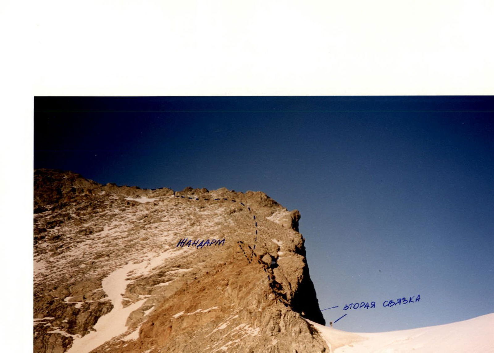
Photo №6. General view of Tokmak pass, gendarme, and slope of the South ridge. Taken 15 minutes from the pass. Plotnikov Alexander (Lomo-compact).
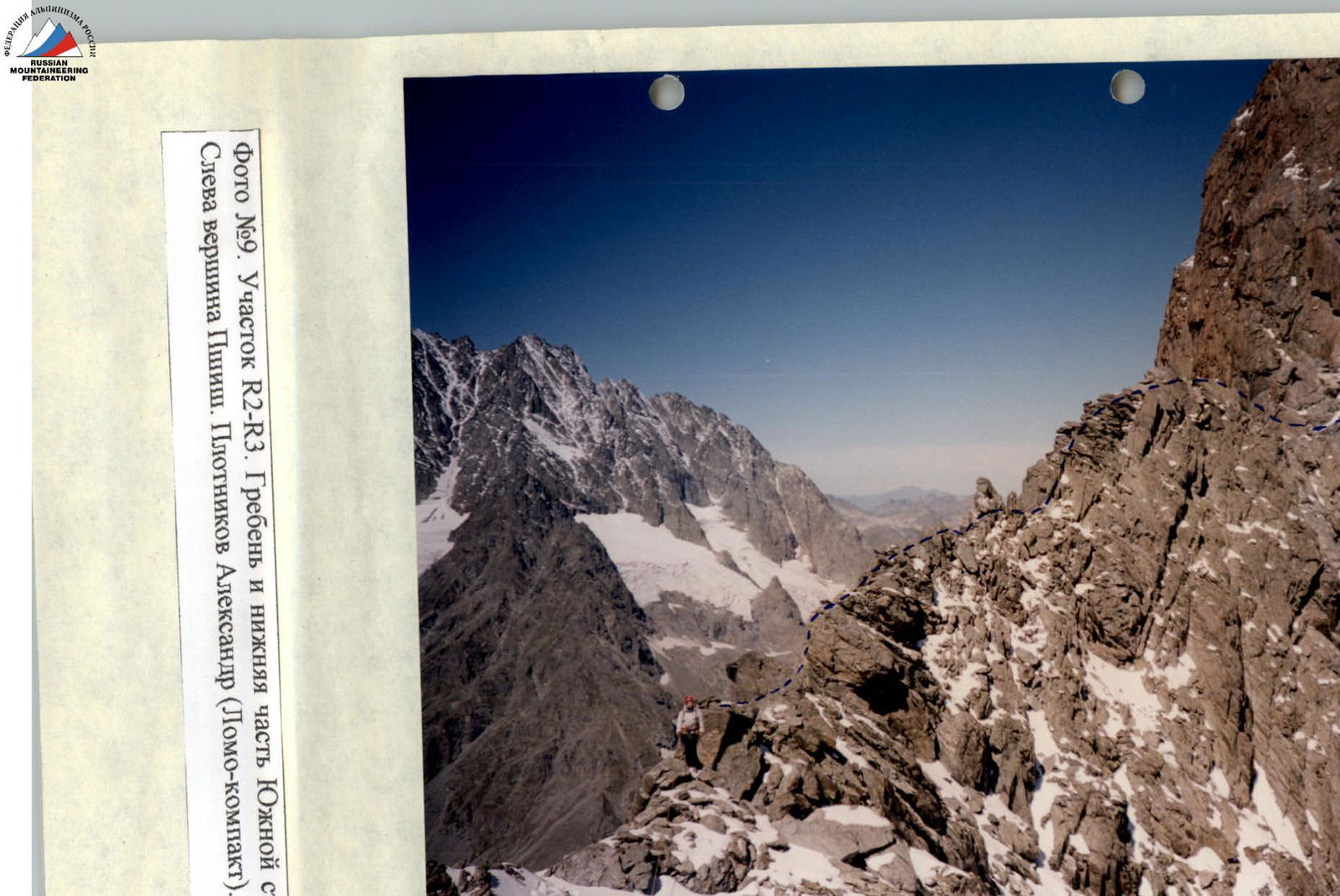
Photo №9. Section R2–R3. Ridge and lower part of the South wall of Tokmak peak. To the left – Psh/https://summitx.info/media/1/HMBmviS7U5MhcpqcQoqZCUZfX6y97mjj/img-11.jpeg","id":64809601}↗)
Photo №10. Section R3–R4. Lower part of the wall. Facade. Photo by Kolokolnikov K. ("Zenit ET", "Helios 44/2").
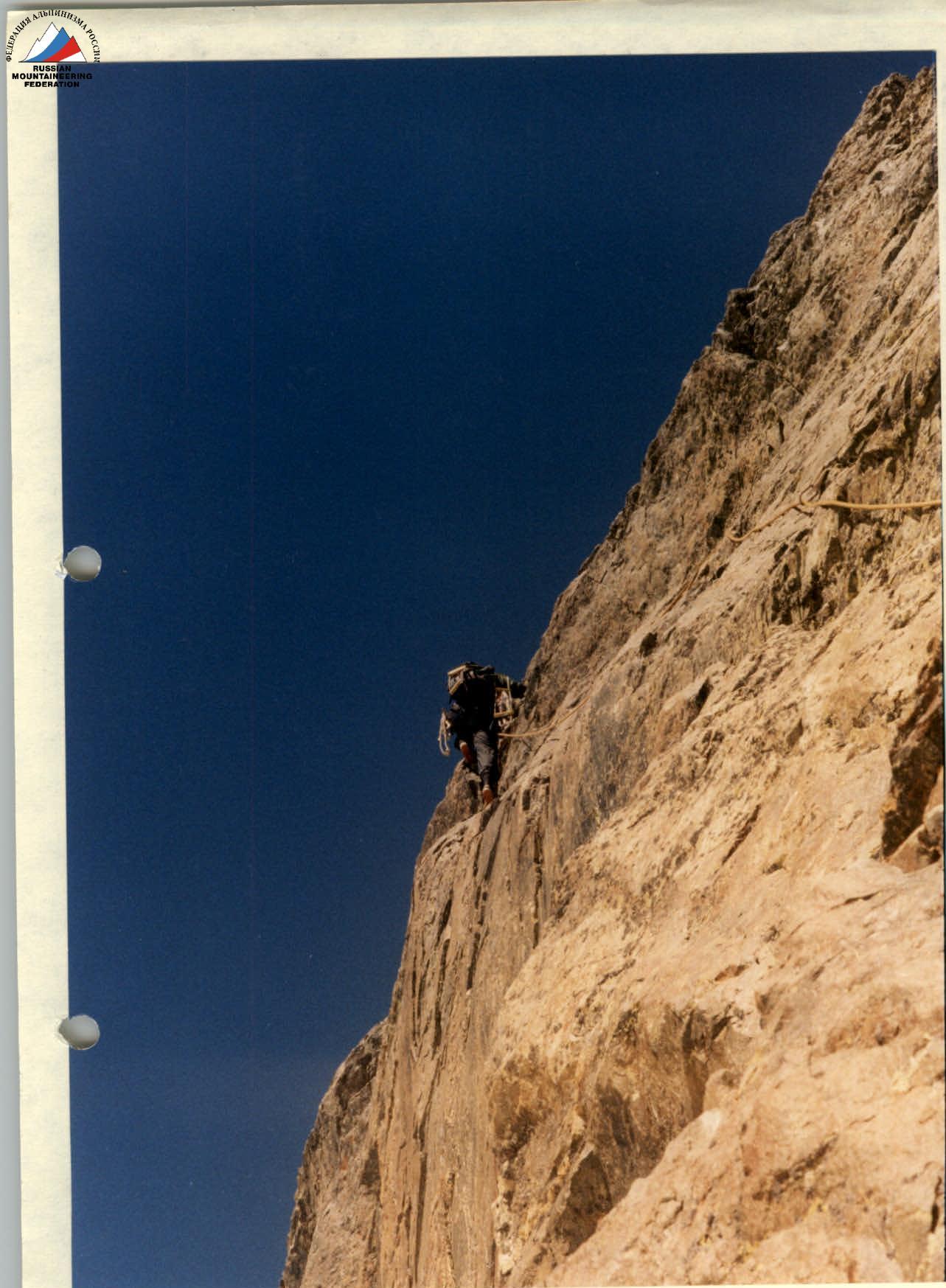
Photo №11. Section R3–R4. Poorly defined ledge, limited by a wall on the left. Wall in profile. Photo by Kolokolnikov K. ("Zenit ET", "Helios 44/2").
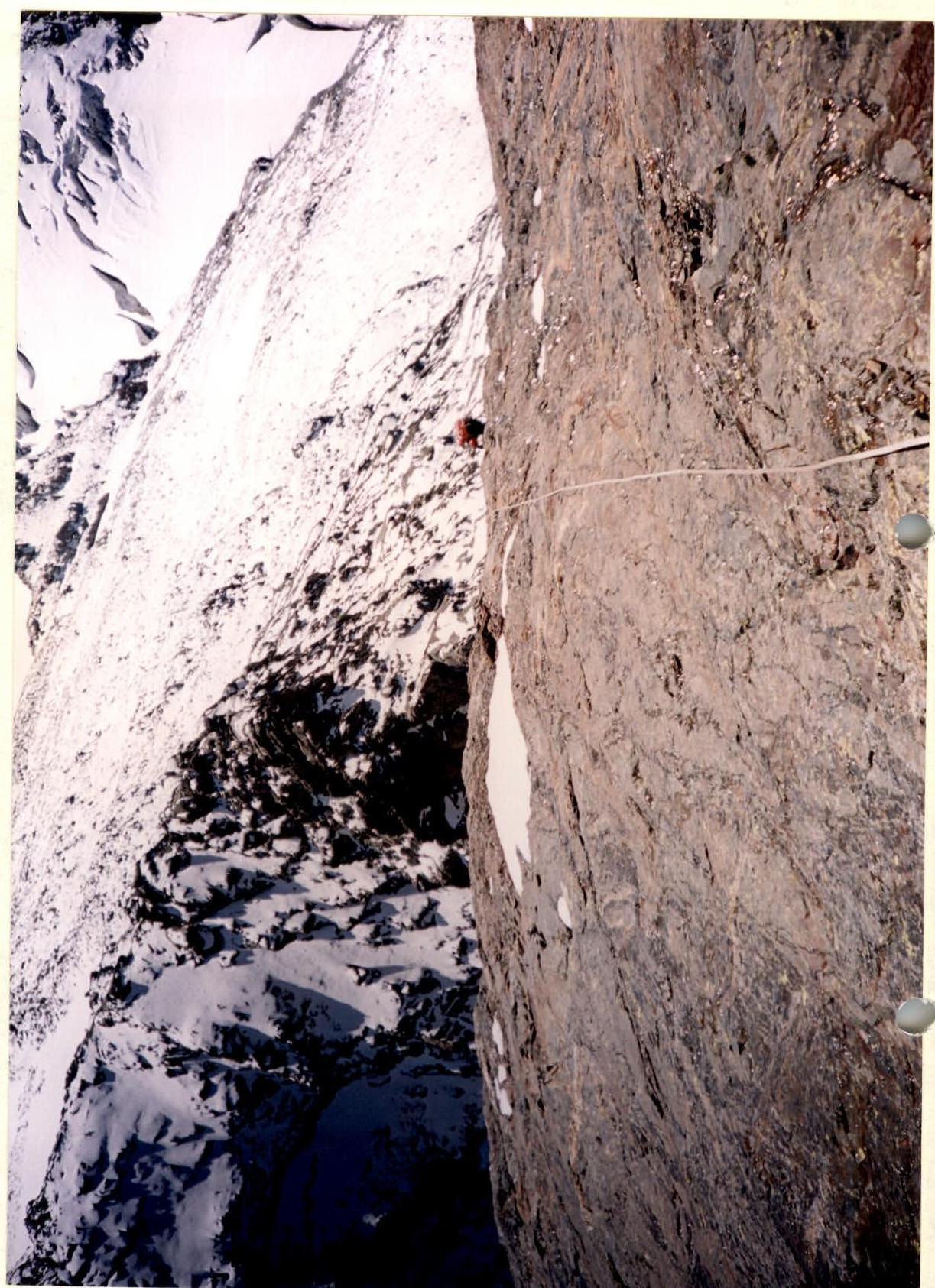
Photo №12. Section R4–R5. Slab lacking relief and South ridge. Taken from the station under the two-meter wall. Plotnikov Alexander ("Lomo-compact").