
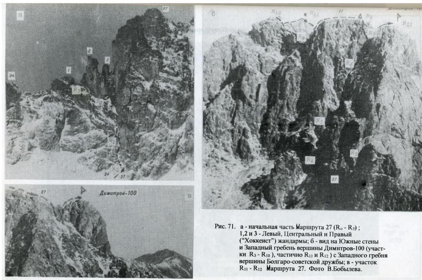
Fig. 71. a – initial part of Route 27 (R0–R3); 1, 2 and 3 – Left, Central and Right ("Hockey player") gendarmes; b – view of the South walls and West ridge of Dimitrov-100 peak (sections R3–R10), partially R11 and R12 – from the West ridge of Bulgaro-Soviet Friendship peak; c – section R11–R12 of Route 27. Photo by V. Bobylyov.
View from the North
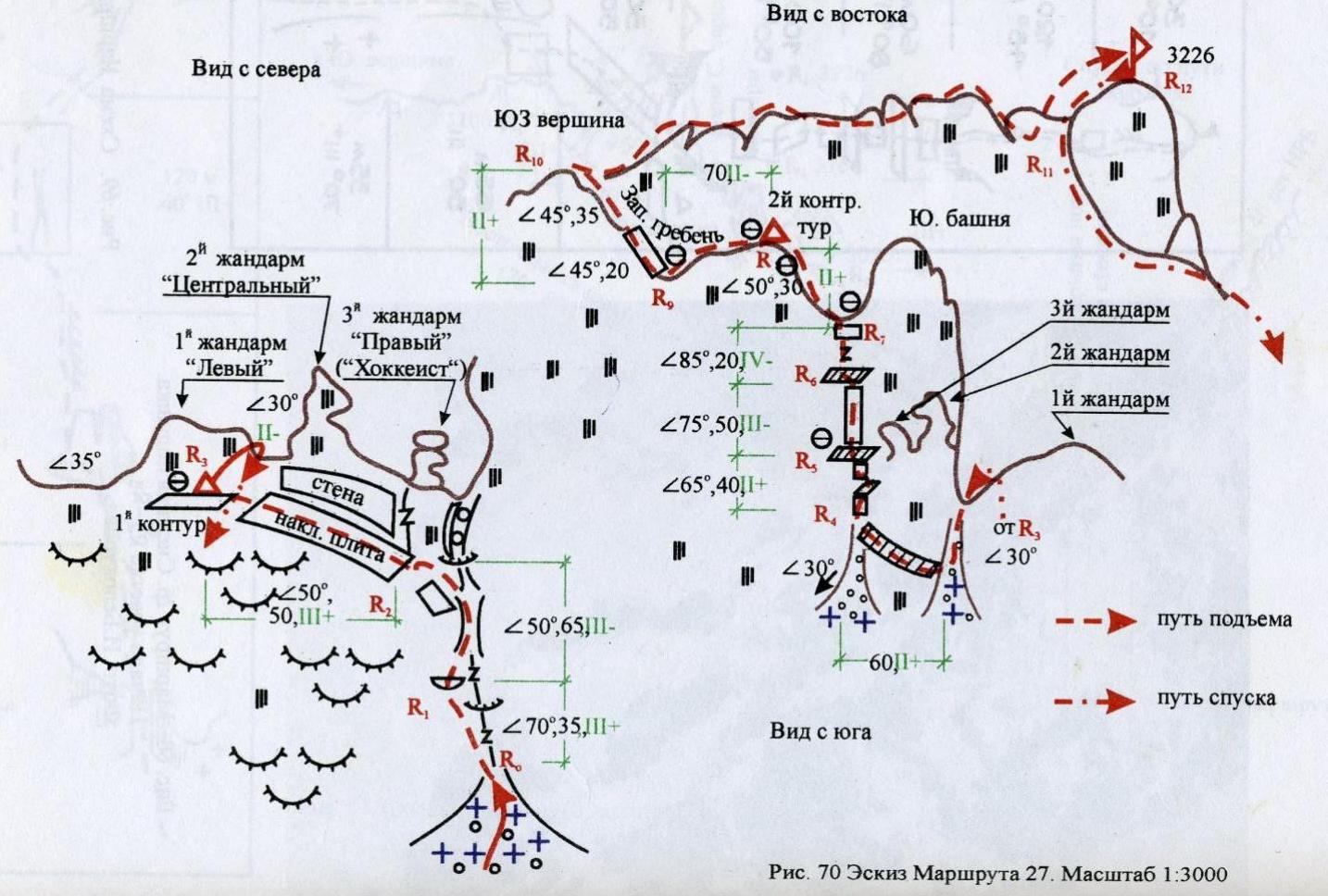
Fig. 70. Sketch of Route 27. Scale 1:3000
Route 27 (Fig. 69, 70). The path to the assault camp "At the lake" under the southern slopes of the 60th anniversary of KChAO peak is described earlier (Route 22). From the base camp "Ice farm" to the specified assault camp – 4–5 hours.
The approach path to the beginning of the described route partially coincides with a similar path to Route 26 (3A). From the base of the ascent on Route 26, you need to turn 90° left, towards the saddle between Bulgaro-Soviet Friendship peak and the South tower of Dimitrov-100 peak. There are three gendarmes on the saddle. The direction should be kept towards the base of the junction of the saddle wall and the South tower wall. A couloir descends here from under the right gendarme "Hockey player". The start of the route. Movement on 30–40° snow. From the "At the lake" overnight stay – 2 hours 30 minutes.
The beginning of Route 27 coincides with Route 24 (up to R3). Section R0–R1 (Fig. 71a). Along the left part of the couloir (smoothed gneiss granite) 35 m to a convenient reception point (chip, shelter). At the same time, the overhang encountered after 25 m is bypassed on the left with an exit above it. α = 70°. 3 stoppers.
Section R1–R2. Upwards along the gradually expanding couloir with an exit to the wall of the Central gendarme along smoothed inclined rocks. 2 stoppers. After 35–40 m, the couloir turns into a vertical complex couloir with cams and an overhang. The latter remains to the right of the route. Length – 65 m, α = 50°.
Section R2–R3. Left-up, along the wall of the Central gendarme, under the wall of the Left one, 50 m. Here, on a narrow shelf, the first control cairn – 3 stoppers, α = 50°. 5 m from the control cairn to the right-up, there is a saddle between the Left and Central gendarmes. From it, a snow-covered scree couloir goes south.
Section R3–R4 (Fig. 71b). Down the couloir about 20 m (α = 30°) to the first shelf, allowing to bypass the Central and Right gendarmes on the left (from the south). On the shelf, first with a slight descent, then a horizontal traverse (hook) and, finally, an ascent – an exit to a level approximately corresponding to the mark of the first control cairn – to the head of the second (from R3 to the west) snow-covered scree couloir. The length of the section is 60 m.
Section R4–R5. The couloir rests against a 5 m high wall with a chip in the upper part and a steepness of 80°. Directly on the wall (1 stopper) on a sloping narrow shelf. Along it to the right-up 15 m. Steepness 50°. Hook. From the end of the shelf upwards to the left 20 m along weakly destroyed rocks with a steepness of 60° using 2 stoppers on a wide shelf.
Section R5–R6. From the shelf 50 m straight up along monolithic rocks towards the gap between the South tower and the West ridge to the second shelf on the wall. Steepness from 80° at the beginning to 60° at the end of the section. 2 hooks and 2 stoppers.
Section R6–R7. From the shelf straight up 10 m along the couloir and further along the wall (10 m) into the gap of the West ridge. The key point of the route! 2 stoppers in the couloir, 1 – before exiting into the gap. Steepness: at the beginning – 90°, at the end – 80°.
Section R7–R8. From the gap to the left-up (alternate movement along the ridge using ledges) to the second control cairn at the highest point of the West ridge between the South-West peak and the South tower. α = 50°, 30 m.
Section R8–R9. Descent along a gentle weakly destroyed ridge to the saddle before the South-West peak with insurance through ridge ledges. α = 30°, 70 m.
Section R9–R10. Along an inclined (~45°) slab with cracks convenient for using stoppers, 1 stopper, 20 m.
Further 45 m along the ridge to the South-West peak.
– Cairn.
Section R10–R11. The entire path goes mainly along the watershed part of the narrow ridge, only occasionally with small descents and ascents to bypass the walls and elevations on the ridge to the right, 260 m. Before the summit ridge, a descent of 30 m to the base of the last elevation before this climb, where (on the wall) a slab with a bas-relief of G. Dimitrov, installed since May 1982 by participants of the Soviet-Bulgarian expedition. There are enough ledges for insurance.
Section R11–R12 (Fig. 71c). First (20 m) along a narrow couloir (α = 45°) exit to a 30-degree ridge leading to the summit and to the right; along it – 30 m to the cairn on the summit tower.
The entire massif and almost the entire route (except for the descending start of section R3–R4) pass along monolithic (on section R8–R9 – weakly destroyed) snow-covered rocks of granitoid composition.
It takes 6–7 hours to overcome the route.
Descent:
– back to point R11, – then along Route 26, – further to the "At the lake" camp.
Comments
Sign in to leave a comment