
| Climbing Category | — Rock |
|---|---|
| Climbing Area | — Western Caucasus, North-West spur of the Sofiysky ridge between the Psyish and Sofiya rivers valleys. |
| Peak, Route | — 3226 "Dimitrov-100" (proposed by the first ascenders) via the East couloir and North ridge. |
| Proposed Category | |
| of Difficulty | — 3А |
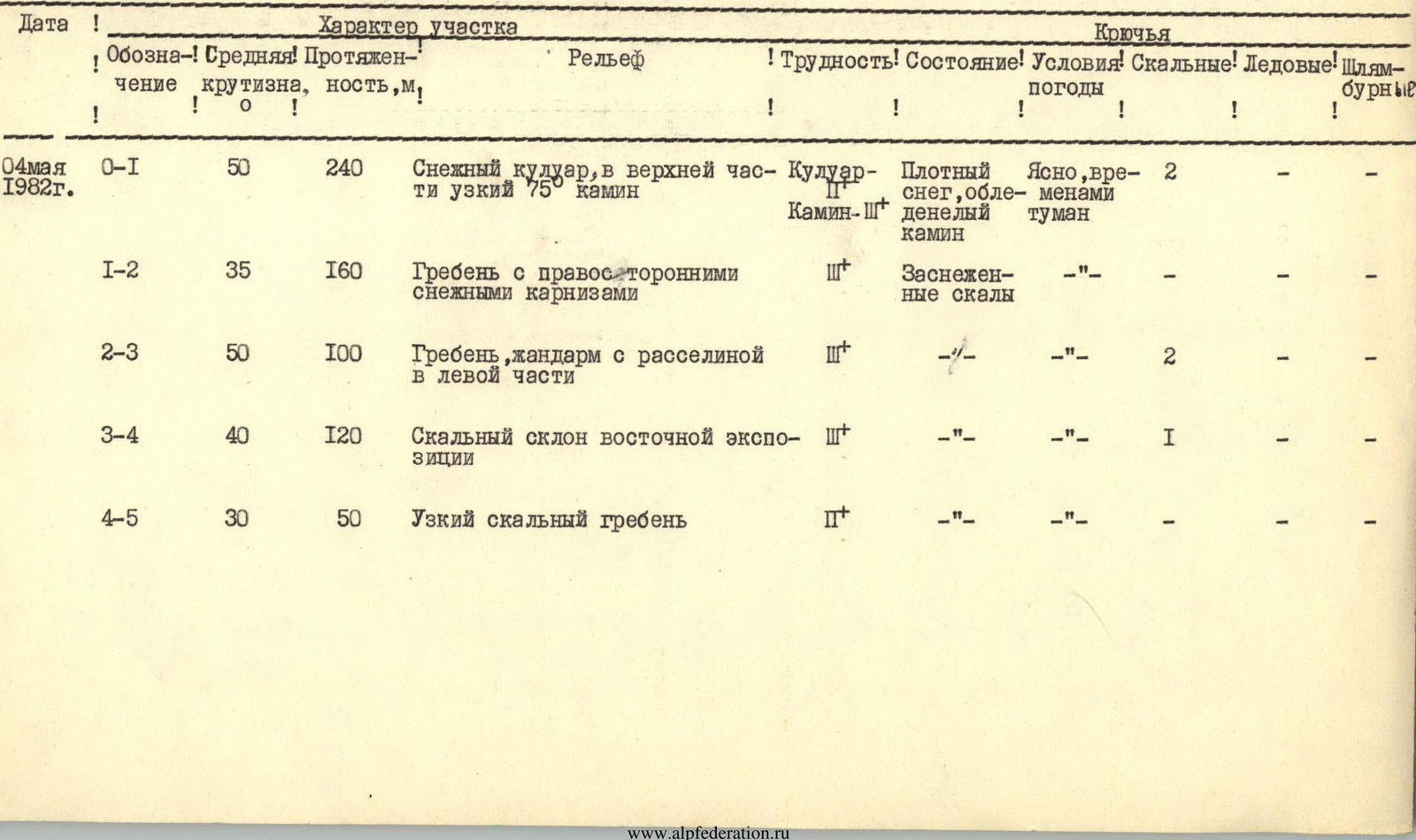
| Route Description | — Combined (snow and rock), absolute height difference 450 m. |
| Number of Pitons Driven | — 5 (on ascent) |
| Number of Climbing Hours | — 8.5 |
| Number of Overnights | — not required on the route |
| Climbing Leaders | — From BNR |
| Beshev S., Master of Sports | |
| From USSR | |
| Zaporozhchenko E., Candidate for Master of Sports | |
| Team Members | — From BNR |
| Semerdzhiev N., Master of Sports | |
| Popov N., 1st class | |
| From USSR | |
| Yanchenko V., 1st class | |
| Gavrilov I., 1st class | |
| Belokurov I., 1st class | |
| Rozhkov A., 1st class | |
| Gorda R., Candidate for Master of Sports | |
| Team Coach | — Popov V.P., Master of Sports USSR |
| Date of Ascent | — May 4, 1982 |
| and Descent |
The unnamed peak 3226 m (absolute height — according to the state topographic plan M 1:25000) is a key point for the massif rising above the Karadzhash tract, in the extreme north-western end of the Sofiysky ridge. It is clearly visible as a standalone peak from various locations in the upper reaches of the Sofiya, Psyish, and Bolshoy Zelenchuk rivers hydrographic system (see photos 1, 2, and 3). To the NNW of it lies the peak named after the XIX Congress of the Komsomol (3171 m), to the SE — the peak named after Bulgarian-Soviet Friendship (3206 m), the first ascents of which were made by climbers from the Stavropol Krai Sports Committee in May 1982.
The peak 3226 m, as an object of the first ascent in honor of the 100th anniversary of G. Dimitrov's birth, was chosen during reconnaissance trips in November and December 1981, as well as January 1982. It was approved by the coaching council of the joint Soviet-Bulgarian expedition "Arkhyz-82" in May 1982.
The most acceptable route for the first ascent seemed to be the route (in its initial part) via the steep snowy couloir of Eastern exposure, the relative avalanche safety of which was assessed during the last reconnaissance on April 30, 1982, by a specialist in snow and avalanches from the High Mountain Geophysical Institute, Candidate of Geographical Sciences A. Runich.
The nearest classified peak ~ 3200 m, 1B category of difficulty, is located to the southwest of the Stolicny pass.
The approach to the start of the route can be made via two options:
- from the "Syrzavod" clearing up the Kasha-Eshek river;
- from the "Sofiya" shelter up the Gammash-Chat river.
The first path is questionable in terms of avalanche safety and, at least until the beginning of May, it is not recommended. The second one is more preferable. The group of first ascenders used the approach from the "Sofiya" shelter. This option is described below.
From the "Sofiya" shelter (absolute height 1830 m), through the snow (it melts in the shelter area around May 10-20), up the Gammash-Chat river to the first ledge, the ascent to which is made from the right via the cones of avalanches descending in winter from the peak named after Zaimov. At the top, there is a lake — "Zapятая" (Comma). To the right of the lake (covered with snow until the end of May):
- up the snowy slope to the base of the second ledge;
- in the right part of the base — a wide snowy couloir;
- up it to the upper, inclined part of the ledge;
- turn right and with a 20-degree ascent to the site of the assault camp in the immediate vicinity of the start of the route.
Overnight stay — on snow at the base of the rocky spur extending from the peak 3206 m (see the diagram). Absolute height ~ 2700 m. From the "Sofiya" shelter to the overnight stay 4–6 hours of walking, depending on the snow conditions.
Route Description
From the overnight stay, with an ascent of ~ 80 m up the snowy, on average 35-degree slope to the base of the Eastern narrow snowy couloir between the North peak of the massif 3226 m and the South tower of the massif XIX Congress of the Komsomol, ~ 900 m.
Absolute height — 2780 m. The steepness of the couloir ranges from 35° at the beginning to 50° when exiting to the saddle.
Section R0–R1. In rope teams, on snow, alternating movement straight up towards the saddle, which has an absolute height of 2950 m. The saddle is narrow, on the side of the Bazarnny-Chat valley, above steep walls going deep down, a powerful cornice! The North ridge above the saddle begins with a 7-meter complex, ice-covered wall without holds. Therefore, not reaching the saddle by ~10 m, left-upwards via a chimney ( местами — ice!) ~ 40 m quite complex climbing with an exit to the narrow North ridge. 1.5 hours.
Section R1–R2. Along the ridge (rocks covered with snow, right-sided cornices!) with descents and ascents, alternating movement 4 × 40 m to a snowy pad (photo). Absolute height 3010 m. 0.5 hours.
Section R2–R3. From the pad 40 m up a 45-degree ridge about 10 m wide to the base of a gendarme. Along the left part of the gendarme into the gap between the left edge and the walls of the gendarme, exit to the left shoulder of the latter, ~ 40 m. Then 20 m up to the knife-like watershed part of the ridge, abutting against the powerful wall of the North tower of the massif. 0.5 hours.
Section R3–R4. To the left, along the wall 2 × 40 m, then 40 m with an 80-degree ascent, partly on piton protection and up a steep, snow-covered rocky slope, exit to the ridge leading from south to north to the summit tower. Absolute height 3200 m. 1.5 hours.
Section R4–R5. Along a narrow 30-degree ridge, with h ~ 30 m to the summit part of the tower, dropping off to the west, north, and east with walls. 0.5 hours.
No signs of human presence were found on the summit. A cairn is built for the first time. The rock is granitoid. To the north — a vertical shaft up to 150 m deep. Behind it — a beautiful view of the massif named after the XIX Congress of the Komsomol with the South tower in the foreground (photo).
On a monolithic rock of the pre-summit ridge, participants of the joint Soviet-Bulgarian ascent:
- attached a memorial plaque with a bas-relief of G. Dimitrov using shackles;
- placed in the cairn, along with a note, a capsule with soil from G. Dimitrov's homeland.
The descent — along the ascent path — takes about the same time to the saddle as the ascent. From the assault camp to the summit, the group took 8.5 hours (excluding the time spent on the summit).
The leaders and participants of the first ascent evaluate the route as fully corresponding to the 3А category of difficulty.
The group of first ascenders requests that the peak be named "Dimitrov-100", in honor of the 100th anniversary of whose birth the joint Soviet-Bulgarian expedition "Arkhyz-82" was organized.
From the south, southeast, and northwest, wall routes lead to the summit; a traverse is also interesting:
- as a standalone route — through the South and North towers of the peak;
- as part of a traverse from the Kara-Djash pass to the Zaimov peak (not less than 4B category of difficulty).
Leaders: from BNR
 S. Beshev
E. Zaporozhchenko
May 15, 1982. Pyatigorsk.
Table of Main Characteristics of the First Ascent Route to the "Dimitrov-100" Peak
The first ascent to the "Dimitrov-100" peak (3226 m absolute height) was made on May 4, 1982, via the E couloir and N ridge by the joint Soviet-Bulgarian expedition and subsequently classified as a 3А category route (see photo 1 and "Orографическая схема").
In the immediate vicinity of the peak, there are several more (as of November 15, 1986) classified routes:
- the closest ones — to the peak named after Bulgarian-Soviet Friendship (3206 m) via the SW counterfort 2B category;
- to the peak "40 лет НРБ" (40 years of BNR) via the SSE wall 4А category (photo 1).
The path to the assault camp "U ozera" (By the lake) under the southern slopes of the peak "60 лет КЧАО" (60 years of KChAO) has been described earlier (see also "Orографическая схема"). From the base camp "Ledovaya ferma" (Ice farm) to the said assault camp 4–5 hours. The approach path to the start of the described route partially coincides with a similar path to the 3А route. From the base of the ascent on the 3А route, one needs to turn 90° left towards the saddle between the peak named after Bulgarian-Soviet Friendship and the South tower of the "Dimitrov-100" peak. On the saddle — three gendarmes. The direction should be held towards the base of the junction of the wall of the saddle and the wall of the South tower (photo 2). Here, from under the right gendarme ("Hockey player"), a crevice descends. The start of the route. Movement on 30–40° snow. From the overnight stays "U ozera" ~ 2.5 hours.
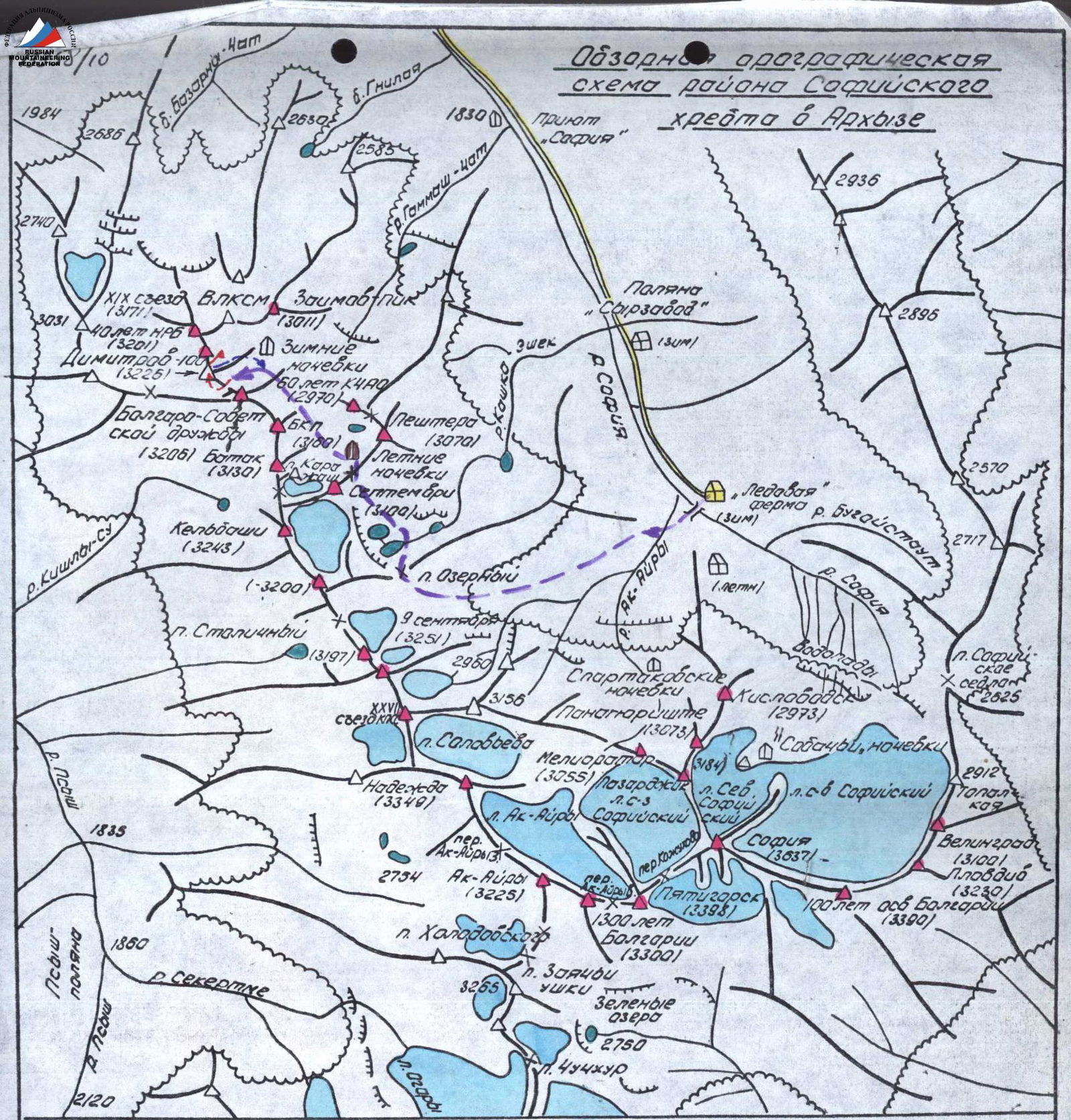
Overview Orographic Scheme of the Sofiysky Ridge Area in Arkhyz
Route Description
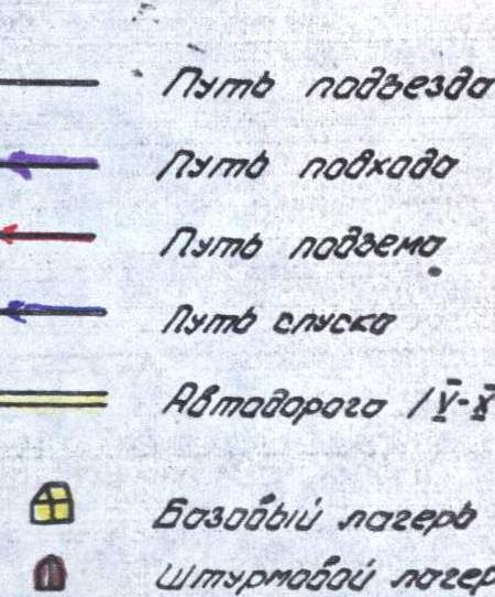
(see "Схема" in a unified symbol system)
Section R0–R1 (photo 2). Along the left part of the crevice (smoothed granito-gneisses) ~35 m to a convenient reception point (a chip, a shelter). At the same time, an overhang encountered after ~25 m is bypassed from the left with an exit above it. d = 70°. 3 stoppers. Category of difficulty — 3.
Section R1–R2 (photo 2). Up the gradually expanding crevice with an exit to the wall of the Central gendarme along smoothed inclined rocks. 2 stoppers. After 35–40 m, the crevice turns into a vertical complex couloir with plugs and an overhang. The latter remains to the right of the route. Length — 65 m, d = 50°, 3.
Section R2–R3 (photo 2, 3). Left — up, along the wall of the Central gendarme, under the wall of the Left gendarme, 50 m. Here, on a narrow ledge, a control cairn! 3 stoppers, d = 50°. 3. 5 m from the control cairn, right — up, a saddle between the Left and Central gendarmes. From it, a snowy talus couloir descends to the south.
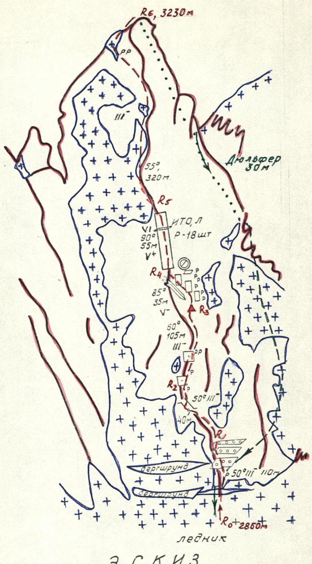
Sketch of the First Ascent Route to the PLOVDIV Peak
Section R3–R4 (photo 3, 4). Down the couloir about 20 m, d = 30° to the first ledge, allowing to bypass the Central and Right gendarmes from the left (from the south). On the ledge: first with a slight descent, then a horizontal traverse (hook), and finally, an ascent — exit to the level approximately corresponding to the mark of the 1st control cairn; into the head of the second (from R3 to the west) snowy talus couloir. The length of the section ~ 60 m, category of difficulty — 2.
Section R4–R5 (photo 4). The couloir abuts against a 5-meter wall with a chip in the upper part and a steepness of 80°. Directly on the wall (1 stopper, 3) onto a sloping narrow ledge. Along it, right — up 15 m (2). Steepness 50°. Hook. From the end of the ledge, up — left 20 m along weakly destroyed rocks with a steepness of 60° using 2 stoppers onto a wide ledge. The overall complexity of the section is evaluated as 2.
Section R5–R6 (photo 4). From the ledge 50 m straight up along monolithic rocks in the direction of the gap between the S tower and the W ridge to the second ledge on the wall. Steepness from 80° at the beginning to 60° at the end of the section. 2 hooks and 2 stoppers. 3.
Section R6–R7 (photo 4). From the ledge straight up 10 m along a crevice and further — as a wall (~10 m) into the gap of the W ridge. The key point of the route! 2 stoppers in the crevice, 1 — before exiting into the gap. Steepness: initially — 90°, at the end — 80°. 4.
Section R7–R8 (photo 4). From the gap, left — up (alternating movement along the ridge using ledges) to the 2nd control cairn on the highest point of the W ridge between the SW peak and the S tower. d = 50°, 30 m, 2.
Section R8–R9 (photo 4). Descent along a gentle, weakly destroyed ridge to the saddle via the SW peak, with protection through ridge ledges. d = 30°, 70 m, 2.
Section R9–R10 (photo 4). Along an inclined (~45°) slab with cracks convenient for using stoppers, 1 stopper, 20 m. Then another 45 m along the ridge to the SW peak. 2. A cairn is complex.
Section R10–R11 (photo 5). The entire path goes mainly along the watershed part of the narrow ridge, only occasionally with small descents and ascents to bypass walls and elevations on the ridge to the right, L = 260 m. Before the summit ridge, a descent ~ 30 m to the base of the last elevation before the rise, where on the parts of the wall, a plaque with a bas-relief of G. Dimitrov is installed, set in May 1982 by participants of the Soviet-Bulgarian expedition. There are enough ledges for protection. 3.
Section R11–R12 (photo 6). First (20 m) along a narrow couloir (d = 45°) exit onto a 30-degree ridge leading to the summit and to the right, along it, 30 m to the summit cairn on the NW tower. The latter drops off with walls to the west, north, and east. Category of difficulty 2.
The entire massif and virtually the entire route (except for the descending start of section R3–R4) pass along monolithic (on section R8–R9 weakly destroyed) snow-covered rocks of granitoid composition and require 6–7 hours.
Descent — first back to point R0, then along the classified 3А route and further to the "U ozera" camp.
Assessment of the first ascent: the route corresponds to the 3А category of difficulty, the nature of the route — rock. Made within the framework of the All-Year-Round Event of the Stavropol Krai Alpine Federation.
Compiled by E. Zaporozhchenko Pyatigorsk, November 1986.
Comments
Sign in to leave a comment