
ASCENT DOCUMENT
- ASCENT CLASS: Rock
- ASCENT REGION: Arkhyz, Stavropol Krai, KTMGV – 2.1.
- PEAK: "Pik 3231" (Main), its height is 3231 m above sea level, ascent via the South-Eastern ridge through the peak "Pik 3231" (Eastern) from the "Stolichny" pass
- ANTICIPATED DIFFICULTY: approximately 2A category of difficulty
- CHARACTER OF THE ROUTE:
- Height difference between the base camp and the peak — 1911 m
- Between the "Stolichny" pass and the peak (Main) — 181 m
- Total route length from the pass to the peak — 845 m
- Average steepness — 40°–35°
- Length of section R1 — 540 m
- section R2 — 220 m
- section R3 — 65 m
- sections R4, R5, R6 — none
- PITOONS DRIVEN: For rock protection — 4 pcs. For artificial footholds — none.
- NUMBER OF CLIMBING HOURS: From the base camp to the peak (Main) — 5.5 hours; from the pass to the peak — 2.5 hours. Descent from the peak to the base camp — 4 hours.
- NUMBER OF NIGHTS: The route was completed without an overnight stay. Possible overnight location — under the "Stolichny" pass on snow.
- GROUP INFORMATION: Leader — Vyacheslav Alexandrovich Shipilov, 1st sports category, instructor-methodologist of the II category. Participants: A.G. Shvyrev, 2nd sports category, Yu.F. Tokarev, 2nd sports category.
- TEAM COACH: Viktor Petrovich Rogovsky, instructor-methodologist of the II category, certificate No. 2357, 1st sports category.
- DATE OF DEPARTURE AND RETURN FROM THE ROUTE: May 5, 1980 at 4:00 from the base camp. Returned from the route to the base camp at 15:20 on May 5, 1980.
 www.alpfederation.ru ↗
REPORT
On the first ascent (variant) to the peak "Pik 3231" (Main) via "Pik 3231" (Eastern), made by a group of climbers from Stavropol Krai on May 5, 1980, in the Arkhyz mountain region (Western Caucasus), Stavropol Krai, west of the "Marukh" pass, Sofiysky ridge.
The Arkhyz mountain region is located on the northern slopes of the Main Caucasian ridge between the Kardyvach region (Krasnodar Krai) to the west and the "Marukh" pass to the east. The region is entirely within Stavropol Krai and is located within 43° north latitude.
North of the Main Caucasian ridge lies the Sofiysky ridge, where this unnamed peak with a height of 3231 m above sea level is located.
The base camp was situated at a height of 1320 m above sea level, 1.5 km from the "Lednikovaya ferma" on a clearing.
From the base camp, upstream along the Sofia river to the tributary from the Ak-Ayry glacier, along which:
- to the right upwards to the "Baran'i lby";
- further to the right into a wide couloir leading to the firn fields;
- up the firn fields to the "Stolichny" pass (from the camp — 3 hours walk).
The peak "Pik 3231" is a section of the Sofiysky ridge (its northwestern part) with two peaks of equal height, located close to each other (200–250 m along the ridge). Further to the northwest, the ridge continues with the Mingi-Kyol-Bashi peak, and to the southeast with the peaks:
- "Pik 3305"
- "Pik 3200"
- "Nadezhda"
and further, peak Sofia.
The ascent was made along the South-Eastern ridge from the "Stolichny" pass through the peak "Pik 3231" (Eastern) to peak "Pik 3231" (Main). The route is ridge-like, rocky, and destroyed.
Composition of the ascent group:
- V.A. Shipilov, 1st sports category, instructor-methodologist of the II category
- A.G. Shvyrev, 2nd sports category
- Yu.F. Tokarev, 2nd sports category. Group leader — V. Shipilov.
The passport, table, photographs, map, and description are attached.
TABLE OF MAIN ROUTE CHARACTERISTICS
| Date | Designation | Steepness | Length | Terrain character | Difficulty | Condition | Weather conditions | Pitons | Ice axes | Bolts |
|---|---|---|---|---|---|---|---|---|---|---|
| May 5, 1980 | R0–R1 | 40° | 80 m | ridge | 1 | destroyed | good | ledges; | simultaneously; | |
| R1–R2 | 50° | 30 m | gendarme | 3 | destroyed | good | 2; ledges; | |||
| R2–R2 | 35° | 500 m | ridge | 1 | destroyed | good | ledges; | |||
| R3–R4 | 40° | 80 m | ridge | 2 | rocks, snow | good | ledges; | |||
| R4–R5 | 45° | 10 m | wall | 2 | destroyed | good | ledges; | |||
| R5–R6 | 30° | 40 m | ridge | 2 | destroyed | good | ledges; | |||
| R6–R7 | 15° | 60 m | ridge | 2 | destroyed | good | ledges; | |||
| R7–R8 | 50° | 35 m | pre-summit shoulder | 3 | blocky | good | 2; ledges; | |||
| R8–R9 | 20° | 30 m | ridge | 2 | snowy | good | alternately, ice axe belay | |||
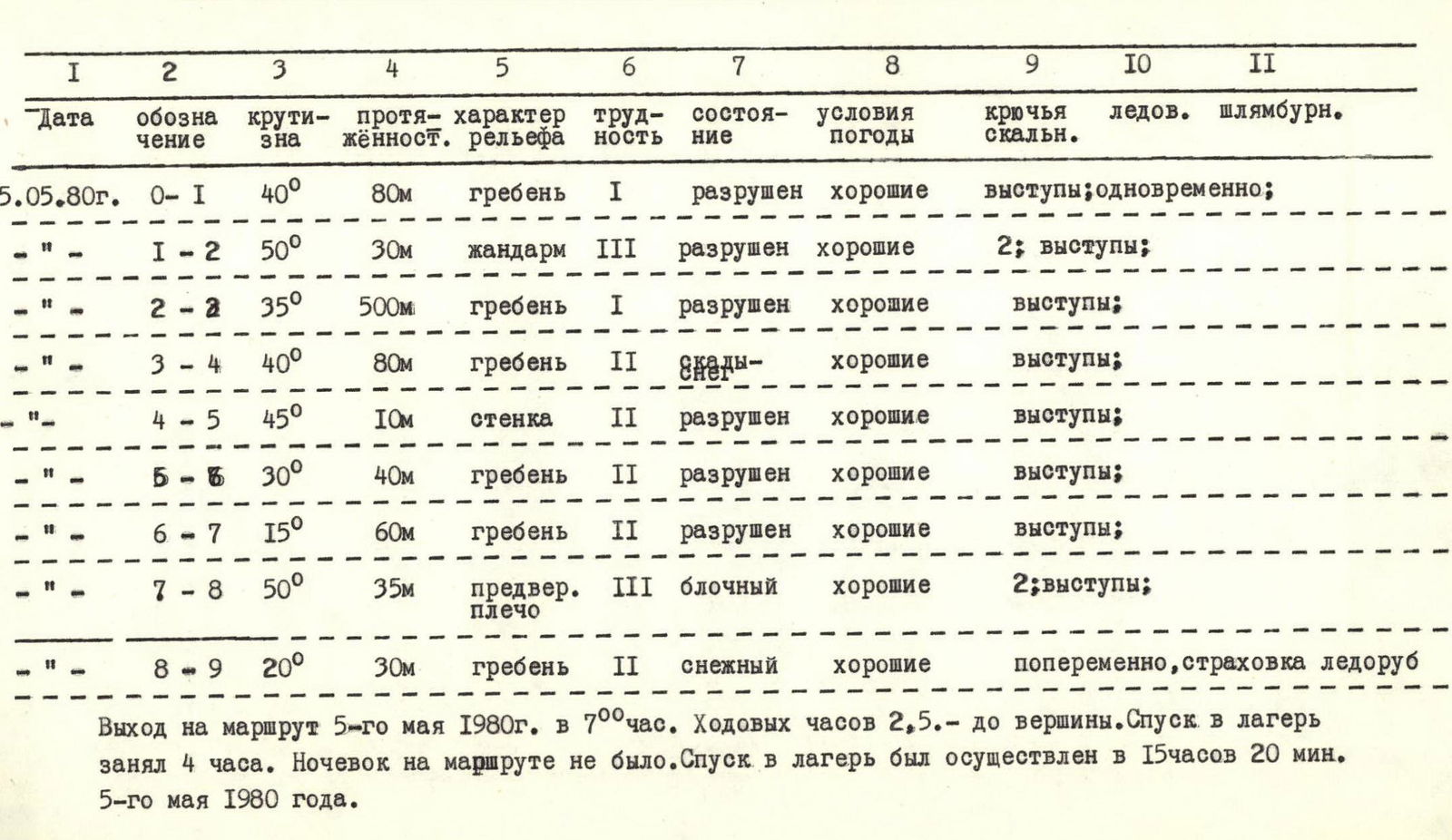 |
Departure on the route on May 5, 1980, at 7:00. Climbing hours to the peak — 2.5 hours. Descent to the camp took 4 hours. There were no overnight stays on the route. Descent to the camp was completed at 15:20 on May 5, 1980.
EXPLANATIONS
To the table of main characteristics and photographic material
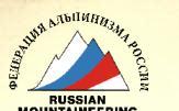
In photo No. 1, sections of the ascent route up to R4–R5 are visible. The photo was taken from the NW ridge of the "Pik 3305" peak.
In photo No. 1, sections R0–R1; R1–R2 are not visible as they were blocked by one of the gendarmes of the NW ridge of the "Pik 3305" peak.
In photo No. 2, sections of the route from R5–R6 to R7–R8 are visible. The photo was taken from the "Pik 3231" (Eastern) peak.
In photo No. 3, the R3–R4 section of the route is visible during its passage by the group.
All photographs turned out to be of poor quality due to fog during the ascent, and the photos were taken during brief clearances.
DESCRIPTION
of the ascent route to the peak "Pik 3231" (Main) along the South-Eastern ridge (through "Pik 3231" – Eastern)
From the base camp located on a clearing near the "Lednikovaya ferma":
- upstream along the Sofia river to the tributary from the Ak-Ayry glacier;
- along the left side of the tributary (orographically) up to the "Baran'i lby";
- further to the right upwards into the gorge leading to the "Stolichny" pass.
From the "Stolichny" pass to the right upwards along the South-Eastern ridge. 80 m along heavily destroyed rocks to a gendarme, which is bypassed on the left along the way with piton protection. After the bypass — exit to the ridge and along destroyed rocks (rockfall hazard) up the ridge for 12–13 rope lengths. The ridge is not steep, 30°–35°, protection through ledges.
The ridge leads to the pre-summit shoulder of "Pik 3231" (Eastern), where rocks alternate with snowy sections. Directly to the peak — exit along a rocky wall 10 m, the wall is not steep, 45° with good holds.
From the peak "Pik 3231" (Eastern) further along the ridge in the direction of (Main) — 40 m descent. Further — 80 m of snowy ridge (Cornices!!!), which leads to a 50° wall. Along the wall 30–40 m with piton protection to the base of the snowy summit, and then exit to the peak "Pik 3231" (Main).
Descent along the ascent path. Ascent from the "Stolichny" pass to the peak "Pik 3231" (Main) took 2.5 hours.
RECOMMENDATIONS:
- Rock pitons — 6–8 pcs.
- Rock hammers — 2 pcs.
- Repschnur consumable — 5 m.
"Pik 3231"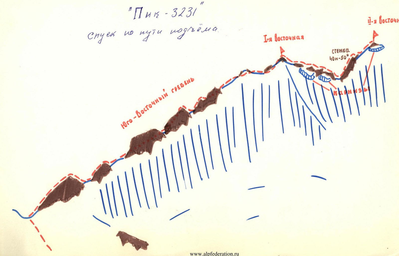
Comments
Sign in to leave a comment