I. Climbing category — rock
- Climbing area — Western Caucasus, Arkhyz, Sofiyskiy ridge between the upper reaches of the Sofia and Psysh rivers.
- Peak, route — peak "200 years of Pyatigorsk" (proposed by the first ascenders), 3398 m, via the NW buttress and ridge.
- Estimated difficulty category — 2A 163 pr. 499
- Route description — rock, via the buttress with a transition to the ridge, elevation gain — 590 m, average steepness — 40°.
- Pitons driven — 3 rock pitons for protection.
- Number of climbing hours — from the start of the route to the summit tower 4 hours (group of 6 people).
- Number of nights — not required on the route.
- Climbing leader: Zaporozhchenko E.V. — Candidate for Master of Sports
Participants: Chuenko S.A. — Candidate for Master of Sports Yankov A.Yu. — 1st Class Climber Zaporozhchenko N.L. — 1st Class Climber Damianiadi I.G. — Master of Sports Kosyakov P.I. — 1st Class Climber
- Team coach — Damianiadi I.G. — Master of Sports.
- Date of departure and return — July 23, 1980.
Legend
Path to the base camp:
- Path to the summit of "200 years of Pyatigorsk" (2A category)
- Path down from the summit of "200 years of Pyatigorsk"
- Path to the summit of "Panagyurishte" (~2B category)
- Path down from the summit of "Panagyurishte"
- Base camp location
The ascent to the previously unnamed peak with the goal of naming it in honor of the 200th anniversary of Pyatigorsk; accomplished on July 23, 1980. The ascent was preceded by a reconnaissance of the area conducted by climbers from the Stavropol Regional Federation in autumn 1979 and spring 1980.

To the east of the summit peak lies the Sofiyskiy Pass (2B category) (in other tourist documents — "Obmanchivy"), to the east of the mentioned pass is Mt. Sofia (3637.4 m) — the highest point of the eponymous ridge, which is a northern spur of the Main Caucasian Range. To the northwest of the massif formed by the peaks Sofia and "200 years of Pyatigorsk", the steep NW Sofiyskiy glacier flows; to the south — short scree slopes give way to the snow-ice O. Sofiyskiy glacier.
The peak "200 years of Pyatigorsk" is a nodal point for the northwest and southwest spurs, descending to the Ak-Ayry glacier. It is marked on all topographic maps and has an absolute elevation of 3398 m according to the latest 1:25000 scale plans. To the far northwest lies the peak Nadezhda (3350 m).
Climbing development in the area began in 1979. In particular, the nearest classified routes are:
- Sofia via the W ridge 3A category
- Nadezhda via the E ridge 1B category
- peak "175 years of Kislovodsk" via the S ridge 1B category.
It should be noted that the absolute elevations given for already classified peaks are in some cases overstated (for peak "175 years of Kislovodsk" by more than 100 m, the actual elevation is 2973 m). The group did not find any signs of climbers on the peak "200 years of Pyatigorsk", or along the entire route — the summit cairn was built by them for the first time. A possible explanation for this circumstance is the apparent "inaccessibility", which upon inspection is an exaggeration.
To the southwest lies a lower peak (3229.6 m), separated by a 100-meter depression. The untraversed traverse of these two peaks with a descent to the Ak-Ayry Pass may approximately correspond to 2B–3A category.
The first ascent of peak "200 years of Pyatigorsk" was made by a sports group from the Pyatigorsk branch of the Spartak Alpine Section in accordance with order No. 24 of the Pyatigorsk City Council of the Spartak Sports Society.
- The group departed at 9:00 am on July 22 from the "Ice" dairy farm located in the upper reaches of the Sofia River (1920 m);
- Moved in the direction of the Ak-Ayry waterfalls, upstream along the eponymous river, which flows into the Sofia River on the left, near the farm (see diagram);
- After crossing the Sofia River and the Ak-Ayry River mouth via footbridges, the group ascended via a well-trodden path on the left (orographically) bank of the river to an amphitheater of steep slopes and rocks, from which a series of beautiful waterfalls cascades (1 hour walk);
- Turning left and traversing grassy slopes with an ascent, the approach is made to the "ram's foreheads", from which the rightmost (eastern) waterfall flows;
- To the right of the waterfall, via the "foreheads" steeply upwards (the path is not always visible) — to a flat meadow located to the right (in the direction of travel) of the Bivak River.
From the "Ice" farm — 2.5–3 hours walk. Absolute elevation — 2550 m*). Water is nearby. Here, up to 10–12 tents for a novice or "badge" team can be accommodated. To the left of the bivouac, behind a ridge-"fence" — a characteristic pointed peak of an unnamed summit, conquered by another group of Pyatigorsk climbers on July 24, 1980, and named by them peak "Panagyurishte" — after the Bulgarian twin city of Pyatigorsk (photo 2).
On the next day, after scouting the approaches to the route, the group moved towards the northwest buttress of the peak, which towered imposingly to the right of the tongue of the NW Sofiyskiy glacier (photo 1). The path goes via moraine hills in the direction of the Ak-Ayry Pass.
On the last moraine scree before the scree slopes (photo 3), to the left and right of which (in the direction of travel) lie small lakes — a small one on the left edge, a larger one on the right — one must turn left, towards the central part of the base of the buttress.
- From the bivouac — 1 hour walk
- Absolute elevation — 2810 m.
Start of the route.
Route Description
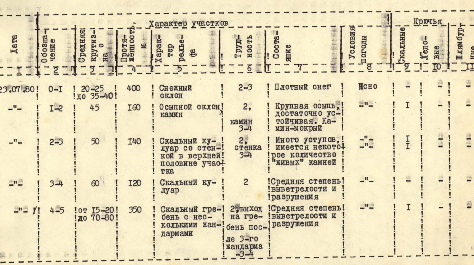
Section R0–R1 (see table, photo 4): via snow covering the glacier, initially gentle, transitioning into a snow "tie" with a steepness of up to 35–40°, to the scree shoulder under the central part of the buttress. Protection via ice axe. Absolute elevation — 2995 m. Movement in rope teams. No open crevasses on the glacier. The snow covering it is dense. *) Here and below, the elevation of intermediate points and route points is given according to the altimeter available to the group.
Section R1–R2: directly upwards via loose scree in the direction of the "gate" between two gendarmes with a small snow patch at the base of the left one. Via a wet chimney 4 m to a ledge (pit for protection). Further via a steep scree slope to the base of a couloir with individual snow patches. Absolute elevation — 3090 m.
Section R2–R3: via the couloir, adhering to the rocks on the right side (alternate protection via outcrops), to the first narrowing with inclined slabs and a 4-meter wall-step (pit). From here, the couloir turns left and after 30 m to the left of it — a wide ledge, where 1–2 tents can be placed and where the group set up a control cairn. Absolute elevation — 3170 m (photo 5). Beautiful view of the Psysh River valley!
Section R3–R4: via the left side of the gradually widening couloir — exit to the northwest ridge, running from the buttress to the summit peak. Sufficient outcrops for protection. Absolute elevation — 3260 m.
Section R4–R5 (photo 6): represents a ridge of northwest aspect with a series of gendarmes. Apart from the summit tower, 3 gendarmes are most pronounced. From point R4, after 30 m — ascent "en face" to the 1st gendarme. Descent from it via the ridge to a rock bridge, to the right of which — scree ledges. Via the ledges on the right side of the ridge, with a gradual gain in height, overcoming short walls, the 2nd and 3rd gendarmes are bypassed. Protection — via outcrops. For training purposes, sections of rope protection are required on individual sections. After bypassing the 3rd gendarme, exit to a narrow western ridge of this gendarme, bounded on the right (in the direction of travel) by a cleft leading to the main ridge. To the left, via the ridge, with pit protection and protection via outcrops (~40 m) — exit to the main ridge. Here, movement goes along the left side of the ridge to the base of the stepped summit tower. Absolute elevation — 3310 m. The tower is climbed in a left-upwards direction with an exit to its sharp summit part (according to the altimeter — 3400 m). The group builds a summit cairn. From the start of the route (point R0) — ~4 hours.
The summit tower is composed of gray granite-porphyry.
Section R5–R6: via the eastern, heavily eroded, steep ridge — to the Sofiyskiy Pass (photo 7). Absolute elevation — 3290 m. Extreme care is required during descent. Alternate movement. Protection — via outcrops, previously thoroughly tested, or with pit protection.
Further — down the glacier (photo 8). The glacier is initially steep, with numerous crevasses and a serious bergschrund (ice screws necessary), then becomes gentler, but becomes steeper again towards the tongue (photo 1). To the assault camp — 1.5–2 hours.
At the assault camp on this day were: an observation group and a rescue team (led by Candidate for Master of Sports USSR O.D. Karpinsky) from among participants in an event that included several ascents (in the following days, another first ascent was made to peak "Panagyurishte" and Mt. Sofia).
At a debriefing conducted in the presence of the release officer and all participants in the event, the ascent was assessed as corresponding to a rock route of 2A category.
Equipment Recommendations
When descending from the Sofiyskiy Pass to the glacier, in the upper and lower parts of the glacier at the end of summer, the following will be required (for protection):
- 3–4 ice screws
- crampons for the last person descending
Main ropes are preferably shorter, 20–30 meters, 4–5 pitons are sufficient.
Leader:
 E. V. Zaporozhchenko
Pyatigorsk, August 1980.
Table of main characteristics of the ascent route to peak "200 years of Pyatigorsk"
 Notes:
- On the descent from the summit, the ridge is "eroded", heavily destroyed and weathered.
- On the descent from the Sofiyskiy Pass, 3–4 ice screws are required.
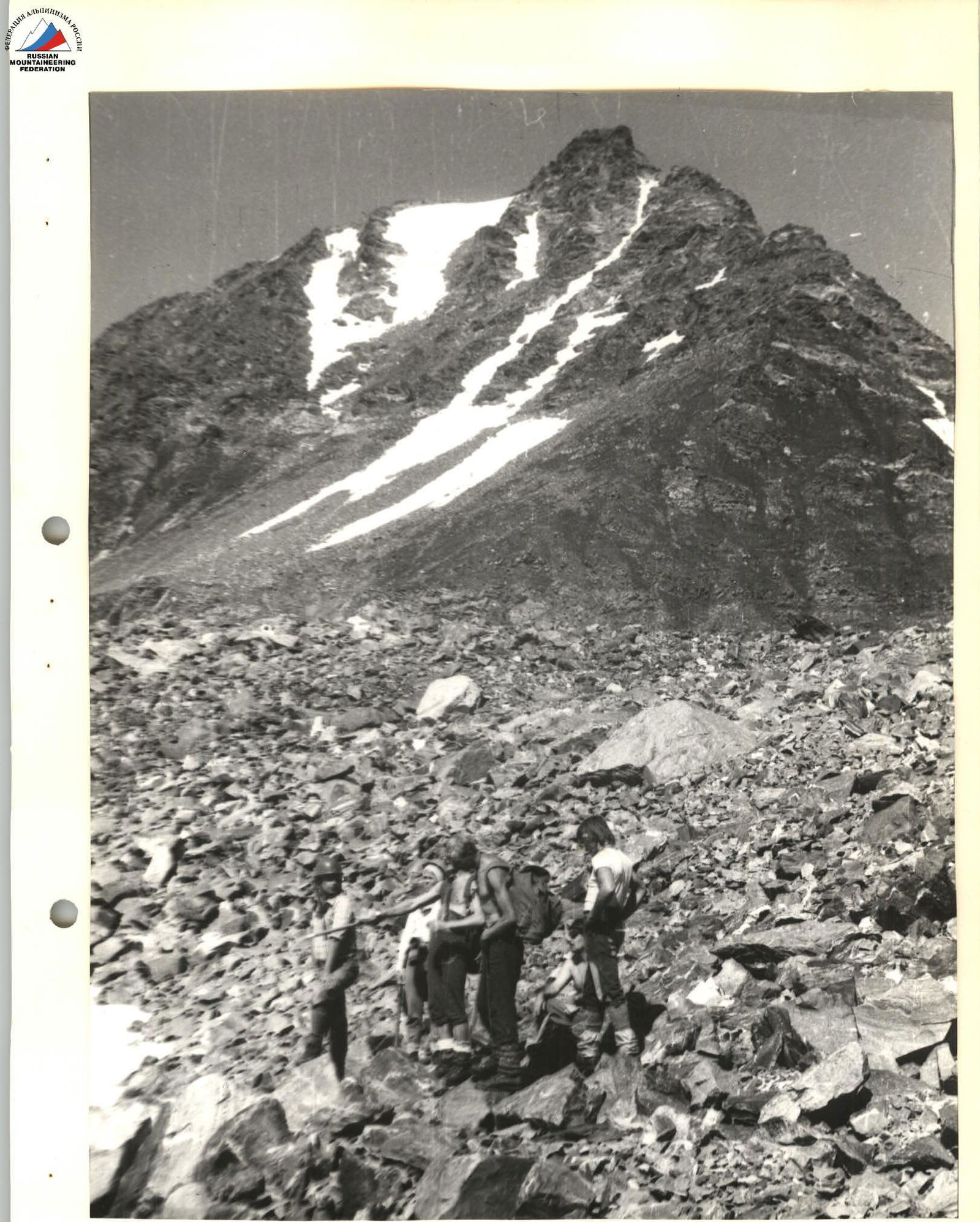
Photo 1. Moraine
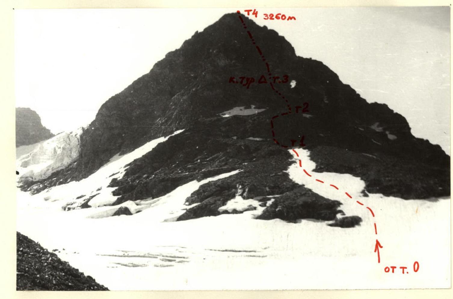
Photo 2. View of the NW buttress from the terminal moraine ridges.
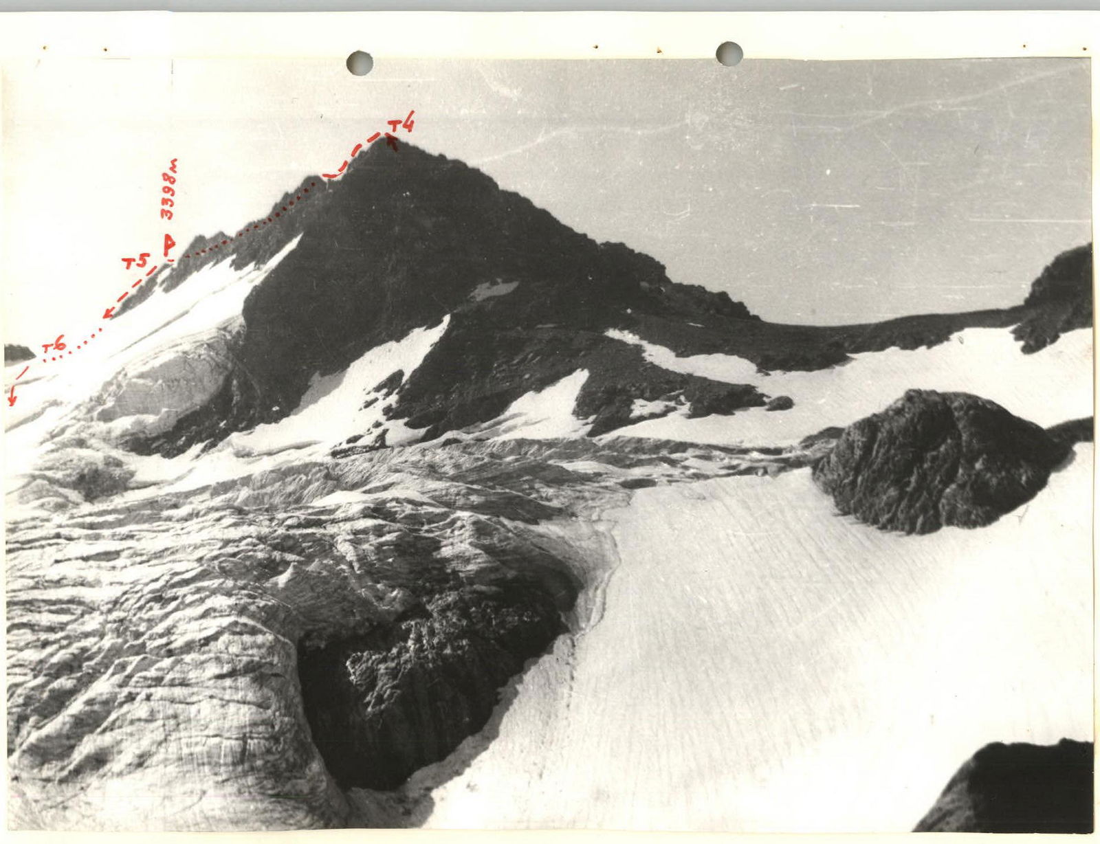
Photo 3. NW and E ridges of the peak (R4–R5 and R5–R6)


