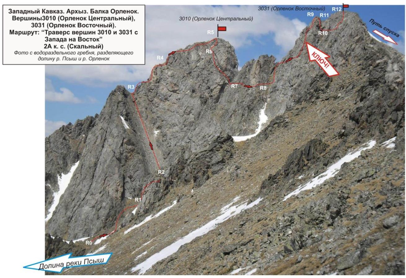
Peaks 3010 (Orlenok Centralny), 3031 (Orlenok Vostochny). Route: traverse of peaks 3010 and 3031 from west to east. Category of complexity — 2A (rocky) Leader: V. Zakharov. Western Caucasus, Arkhyz, Orlenok gully, Orlenok mountain spur. Section in KMGV — 2.1. E-mail — ZHUR58@RAMBLER.RU
Report
On the first ascent of the mountaineering route to peaks 3010 (Orlenok Centralny), 3031 (Orlenok Vostochny) "Traverse of peaks 3010 and 3031 from west to east 2A category of complexity (rocky)". At the competitions in mountaineering "Cup of Victory" NP "Club of northern travels "Sauk-Pai"" (class "First ascents") in May 2013.
Region: Karachay-Cherkess Republic Mountain country: Western Caucasus Gully: Orlenok gully Ridge: Orlenok mountain spur Peaks:
- 3010 (Orlenok Centralny)
- 3031 (Orlenok Vostochny) Route: traverse of peaks 3010 and 3031 from west to
east 2A category of complexity (rocky). Level of complexity: 2A category of complexity (rocky)
(approximately). Prepared by: V. Zakharov, S. Zhuravlev. May, 2013
g.
Description of the peak
Peaks 3010 (Orlenok Centralny) and 3031 (Orlenok Vostochny) — main peaks of Orlenok mountain spur, the extreme western spur of Sofiysky ridge. Orlenok mountain spur is a watershed of the Psyysh river valley (in the west) and the Orlenok river valley (in the north-east). Located on the territory of the North Caucasian Federal District of the Russian Federation, in the Karachay-Cherkess Republic, Arkhyz mountain region.
Peaks 3010 (Orlenok Centralny) and 3031 (Orlenok Vostochny) — ярко expressed peaks of Orlenok mountain spur, located in the south-western part of Orlenok gully, opposite the nodal peak Kara-Jash (3171.0). Peaks are easily identified from the upper cirque of Orlenok gully, as the highest peaks in the right part (by the way). Officially, the peaks have no names, therefore they are given conditional tourist-climbing names — Orlenok Centralny and Orlenok Vostochny, according to the name of the gully where they are located.
Description of the route
The route "Traverse of peaks 3010 and 3031 from west to east" — a typical sports rocky route of 2A category of complexity, with a full set of natural obstacles, corresponding to routes of this level.
Equipment
For the ascent as part of a sports group of 4 people on the route, the following special equipment is necessary:
Personal:
- Standard
- Crampons
- Ice axe
Group:
- Main rope 10 mm — 2×50 m
- Rock hammer — 2 pcs.
- Rock pitons — 16 pcs.
- Ice axe — 1 pc.
- Nuts — 12 pcs.
- Friends — 6 pcs.
- Quickdraws — 16 pcs.
- Loops — 10 pcs.
Ice screws — 0 pcs.
Approach
The ascent is made from a bivouac in the lower cirque of Orlenok gully.
Approach to the lower cirque: from the Taulu glade, cross the Sofiya river by a bridge and ascend along the Orlenok gully — first along a logging road, then along a well-traced path.
The cirque is ярко expressed:
- in winter and spring off-season — snowy,
- in summer — overgrown with high-altitude vegetation.
The height of the cirque above sea level is 1600 m. The ascent from the Taulu glade to the cirque takes 1.5–2 hours.
In the lower cirque of Orlenok gully, there are convenient places for tents, with:
- water (streams)
- firewood for a campfire,
- dry areas, freed from snow in late April — early May.
In the panorama of the cirque, peaks 3010 (Orlenok Centralny) and 3031 (Orlenok Vostochny) are not immediately visible; it is necessary to ascend to the upper cirque of Orlenok gully and pass under the slopes of peak 3226.
The approach to the start of the route: from the campsite in the lower cirque of Orlenok gully to the start of the route — under the rocky bastion — requires:
- an ascent along a path to the upper cirque of Orlenok gully;
- a transition across the watershed ridge of Orlenok spur — across a scree saddle of the ridge, connecting peak Orlenok Vostochny with the peaks — Northern Zubki.
The approach to the start of the route takes about two to three hours.
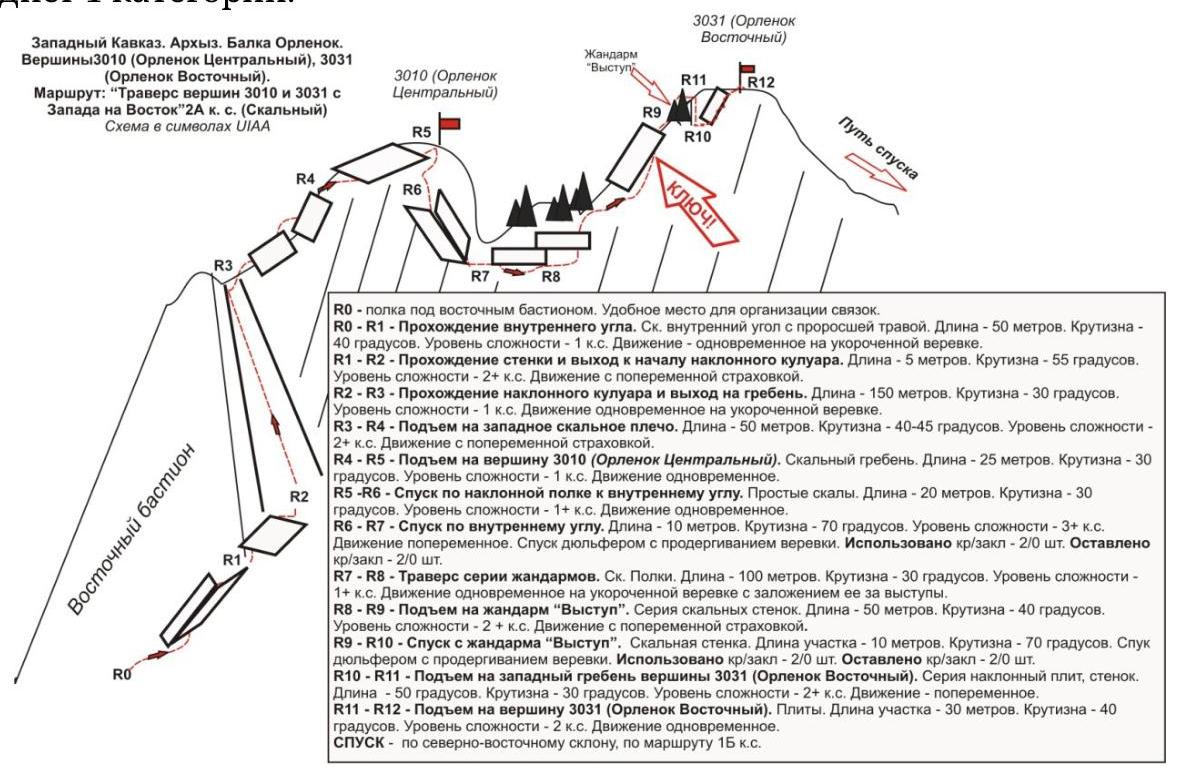
Technical part
The site for organizing rope teams is under the eastern bastion of the south-eastern wall. Further along a grassy, pronounced inner corner to the left (by the way) of the bastion, ascend to a rocky wall. Pass a small (5 m) rocky wall. Then ascend upwards along a scree couloir to a saddle of the western ridge. Along a series of walls, inner corners, and slabs, ascend to peak 3010 (Orlenok Centralny).
On the peak, a cairn is installed. From the peak, descend to a saddle:
- first along an oblique slab,
- then rappel (20 m) along an inner corner and an oblique shelf to the right by the way.
Along a series of shelves, traverse with a bypass of a series of ridge jandarms. Further exit to the ridge and ascent to the jandarm "Vystup". Descent along an inner corner (rappel 15 m) to bypass a series of sharp jandarms (to the right by the way). Further ascent along inclined walls to peak 3031 (en. Orlenok Vostochny).
The key of the route — the route is equally complex throughout its length. The key point can be attributed to the section of ascent to peak 3031 (Orlenok Vostochny).
Peaks are ярко expressed. Cairns are easily found. Descent: upon completion of the traverse, descent along the northern ridge and north-eastern snow-covered slope to the upper cirque of Orlenok gully along route 1B category of complexity.
Recommendations to the instructor
Due to the accessibility of the route in terms of orientation, it can be recommended for training-sports groups (NP-2) and for independent sports groups of разрядники, conducting leadership or training ascents.
Time costs for completing the route for a training-sports group of разрядники of average level of training (NP-2) — 8–10 hours.
Passport
- Number of section according to KMGV — 2010 — 2.1.
Western Caucasus, mountain region — Arkhyz, mountain spur — Orlenok
- Name of the peak: 3010–3031 (Orlenok Centralny – Orlenok Vostochny) 3. Height: 3010–3031
- Route: "Traverse of peaks 3010 (Orlenok Centralny) – 3031 (Orlenok Vostochny) from west to east"
- Category of complexity: 2A category of complexity.
- Character of the route — rocky.
- Height difference of the route: 831 m
- Length of the route: 560 m
- Length of sections of the highest category of complexity:
1 category of complexity — 5 sections — 345 m, 2 category of complexity — 5 sections — 185 m, 3 category of complexity — 2 sections — 30 m
4 category of complexity — 0 sections — 0 m, 5 category of complexity — 0 sections — 0 m, 6 category of complexity — 0 sections — 0 m
- Average steepness: — 50°.
- Number of pitons used:
Used on the route:
- rock pitons — 5
- nuts — 2
- stationary bolt pitons — 0
- ITO — 0
- removable bolt pitons — 0
Left on the route: total — 4; including bolt pitons — 0.
- Exit to the route — 4:30, May 5, 2013.
Exit to the peak — 12:00, May 5, 2013. Return to BL — 15:00, May 5, 2013
- Team's walking hours: — 11 hours.
- Leader: V. Zakharov (1st sports разряд, Moscow).
Participants: V. Rybenko (2nd sports разряд, Moscow)
- Coach: Zhuravlev Sergey Vasilievich, title — Candidate for Master of Sports, instructor-methodologist of 1st
category.
Western Caucasus, Arkhyz, Orlenok gully, Peaks 3010 (Orlenok Centralny) — 3031 (Orlenok Vostochny). Route: "traverse of peaks 3010 and 3031 from west to east" 2A (rocky) (approximately)
Table of natural obstacles on the route:
| Section | Length | Steepness | Character of relief | Category of complexity | Number of pitons/nuts |
|---|---|---|---|---|---|
| R0 — site under the eastern rocky bastion. | Convenient place for organizing rope teams | ||||
| R0–R1 Passage of the inner corner. | 50 | 40 | Rocks, overgrown with grass | 1 | 0 / 0 |
| R1–R2 Rocky wall | 5 | 55 | wall | 2+ | 1 / 0 |
| R2–R3 Exit to the ridge saddle | 150 | 30 | Long inclined couloir. In the upper part, rocky blocks | 1 | 0 / 0 |
| R3–R4 Exit to the first rocky shoulder | 50 | 40 | Rocky wall, inner corner | 2 | 0 / 0 |
| R4–R5 Ascent to peak 3010 (Orlenok Centralny) | 25 | 30 | 1 | 0 / 0 | |
| R5–peak 3010 (Orlenok | ярко expressed. Cairn in the center. | ||||
| Centralny) | |||||
| :-- | :-- | :-- | :-- | :-- | :-- |
| R5–R6 Descent along an inclined shelf | 20 | 30 | Rocky inclined shelf | 1+ | 0 / 0 |
| R6–R7 Rappel along an inner corner. | 20 | 70 | Descent along rocks — rappel (Stationary loop on a ledge) | 3+ | 2 / 0 |
| R7–R8 Descent under a series of jandarms. | 100 | 30 | Rocky shelf. | 1+ | 0 / 0 |
| R8–R9 Ascent to the jandarm "Vystup" | 50 | 40 | Series of walls to the left of the ridge | 2+ | 0 / 2 |
| R9–R10. Descent from the jandarm "Vystup" | 10 | 70 | Descent along rocks — rappel. (Stationary loop on a ledge) | 3+ | 2 / 0 |
| R10–R11. Ascent to the ridge. | 50 | 30 | Along a series of inclined shelves along the wall upwards | 2 | 0 / 0 |
| R11–R12. Ascent to peak 3031 (Orlenok Vostochny) | 30 | 40 | Slabs, rocky slope. | 2 | 0 / 0 |
| R12–peak 3031 (Orlenok Vostochny) | Cairn in the center of the peak | ||||
| Descent | Along the NE slope, along route 1B category of complexity |
Total
Length of the route — 560 m. Average steepness — 40°. Character of relief — combined
Sections:
- 1 category of complexity — 5 sections — 345 m
- 2 category of complexity — 5 sections — 185 m
- 3 category of complexity — 2 sections — 30 m
- 4 category of complexity — 0 sections
Number of pitons and nuts used: 5 (2). Number of pitons and nuts left: 4 (0)
Western Caucasus. Arkhyz. Orlenok mountain spur. Peak — 3010 (Orlenok Centralny). Route: "Traverse of peaks 3010 and 3031 from west to east" 2A category of complexity. (Rocky)
Photo of characteristic relief of the ridge when exiting to peak 3031. May, 2013
g.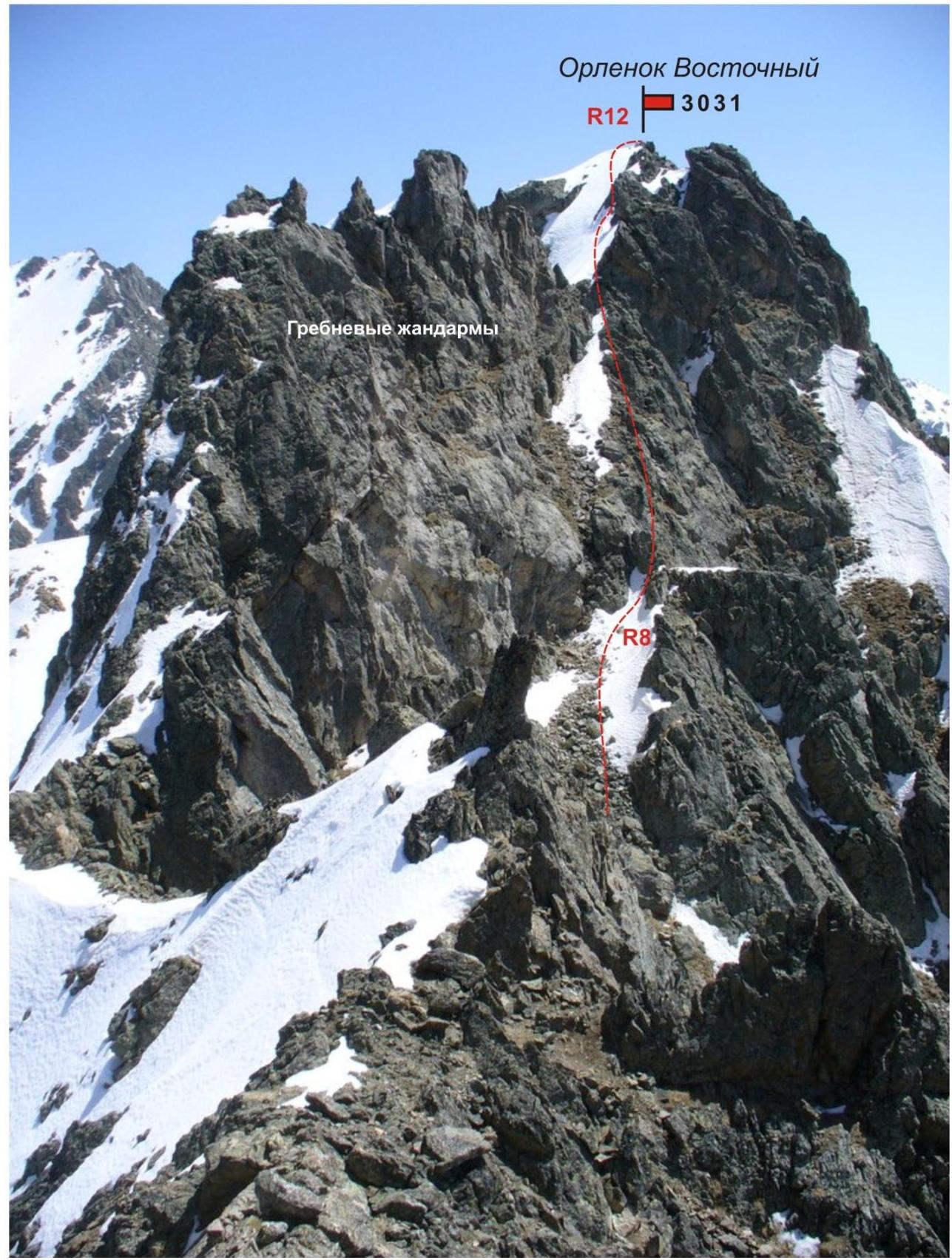
Western Caucasus. Arkhyz. Orlenok mountain spur. Peak — 3010 (Orlenok Centralny). Route: "Traverse of peaks 3010 and 3031 from west to east" 2A category of complexity. (Rocky)
Ascent along a couloir on section
R2–R3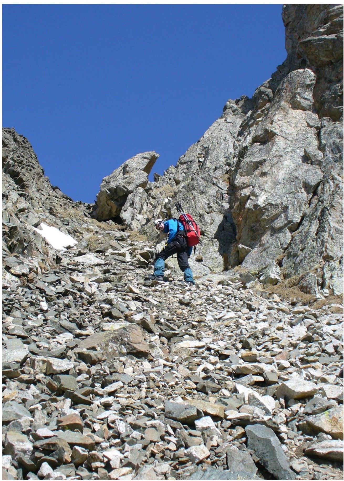
Western Caucasus. Arkhyz. Orlenok mountain spur. Peak — 3010 (Orlenok Centralny). Route: "Traverse of peaks 3010 and 3031 from west to east" 2A category of complexity. (Rocky)
Photo on the saddle of the western ridge. May, 2013
g.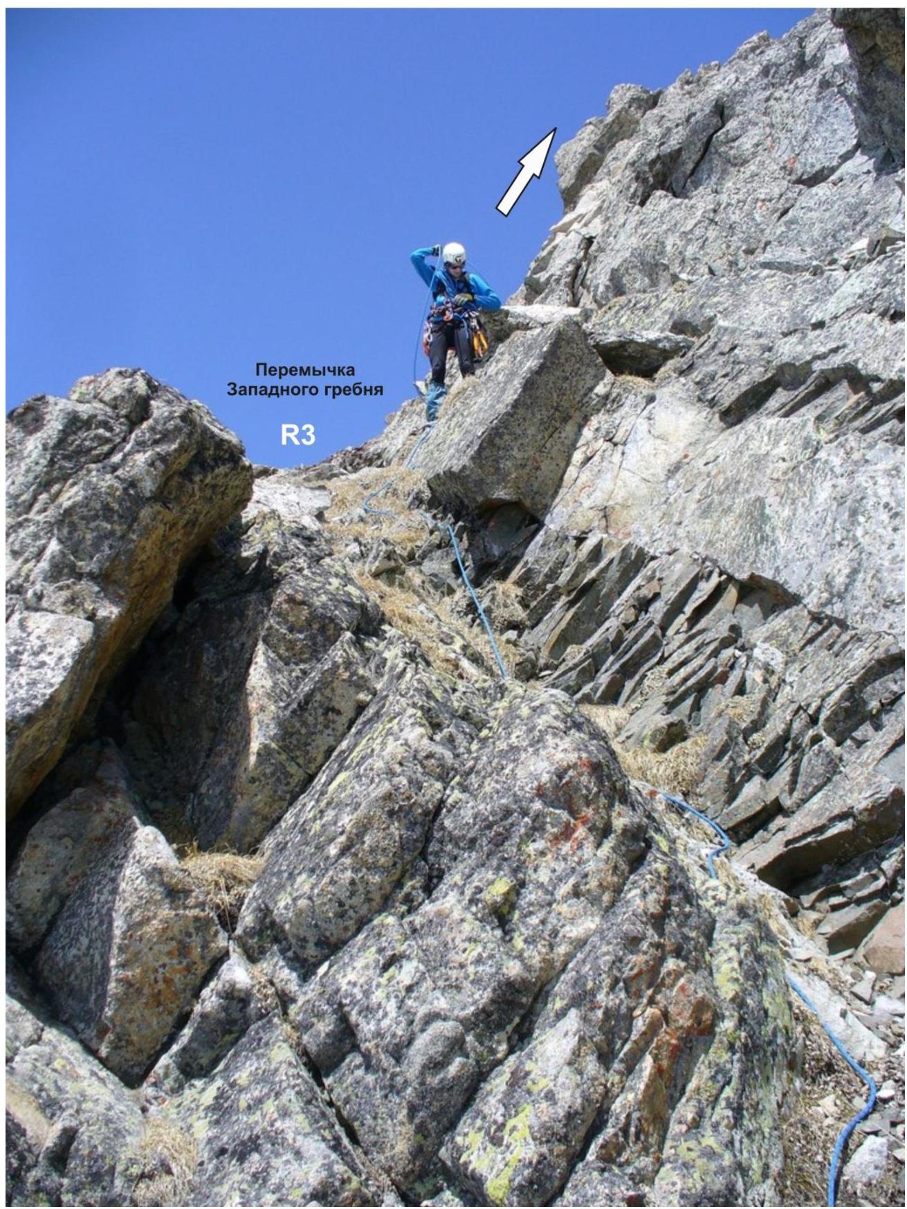
Western Caucasus. Arkhyz. Orlenok mountain spur. Peak — 3010 (Orlenok Centralny). Route: "Traverse of peaks 3010 and 3031 from west to east" 2A category of complexity. (Rocky)
Photo of characteristic relief of the ridge when exiting to peak 3010. May, 2013
g.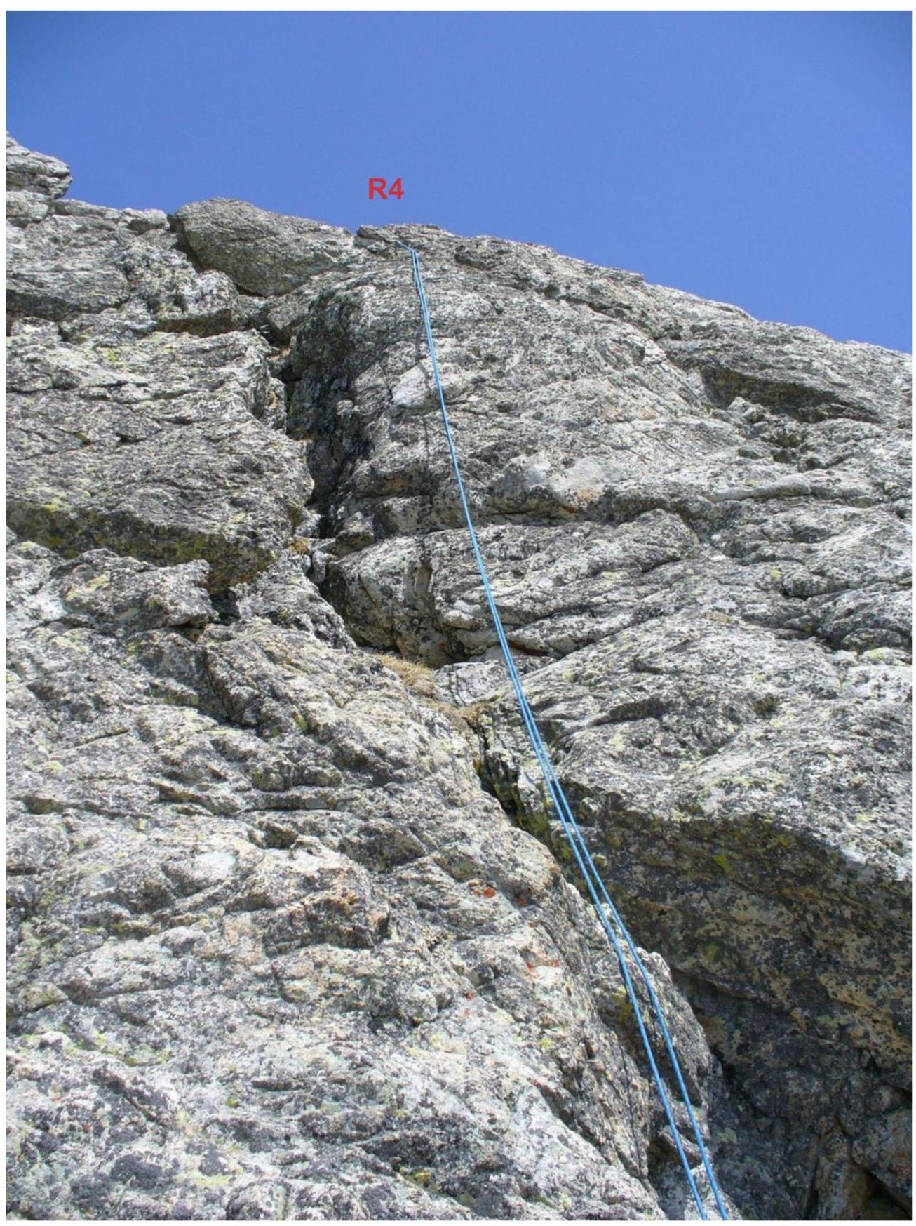
Western Caucasus. Arkhyz. Orlenok mountain spur. Peak — 3010 (Orlenok Centralny). Route: "Traverse of peaks 3010 and 3031 from west to east" 2A category of complexity. (Rocky)
Photo of characteristic relief of the ridge when exiting to peak 3010. May 2013
g.
Western Caucasus. Arkhyz. Orlenok mountain spur. Peak — 3010 (Orlenok Centralny). Route: "Traverse of peaks 3010 and 3031 from west to east" 2A category of complexity. (Rocky)
Photo of characteristic relief of the ridge when exiting to peak 3010. May 2013
g.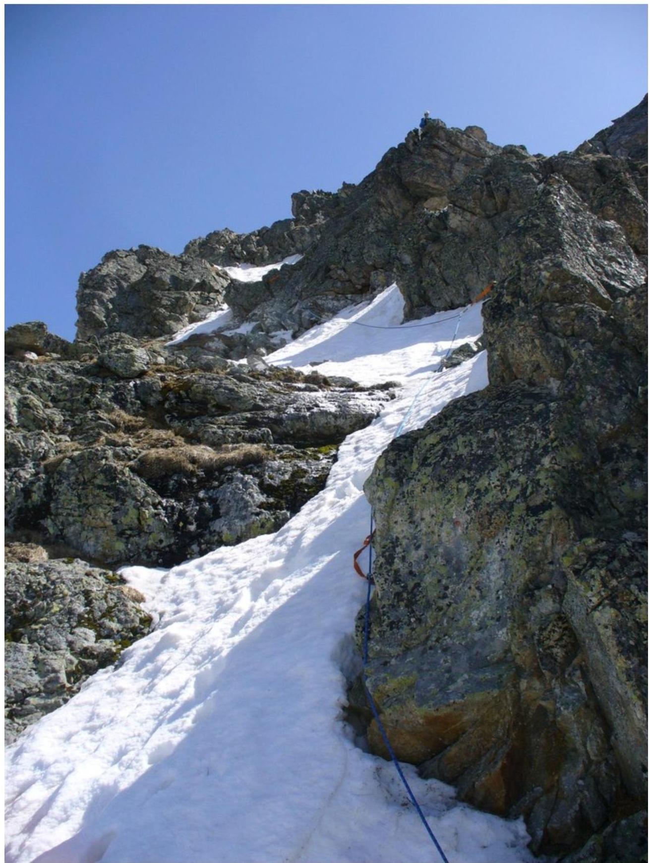
Western Caucasus. Arkhyz. Orlenok mountain spur. Peak — 3010 m (Orlenok Centralny). Route: "Traverse of peaks 3010 m and 3031 m from west to east" 2A category of complexity. (Rocky)
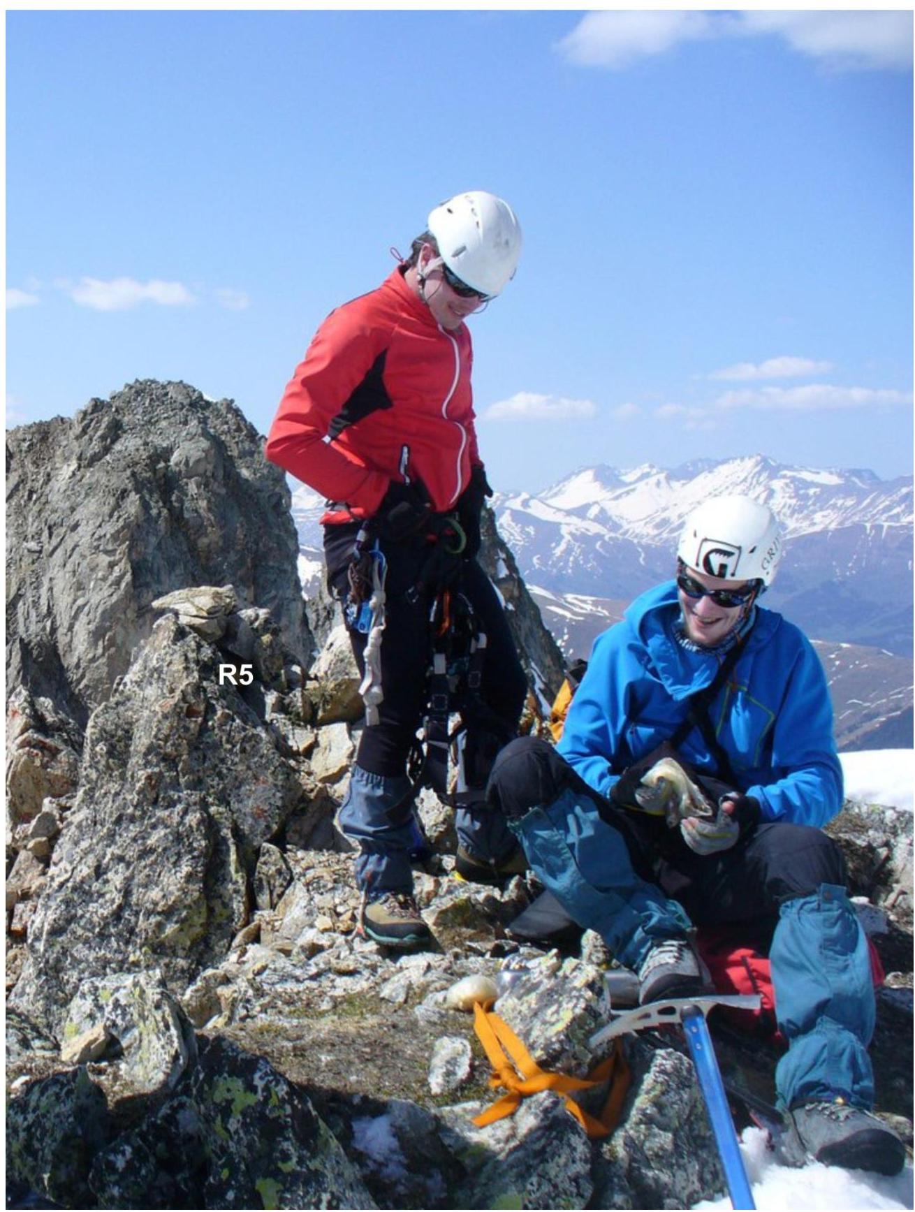
Photo on peak 3010 m (Orlenok Centralny), May 2013
g.