Peaks:
- Orlenok Eastern (3140.0)
- 3010.0
- 3000.0
- 2900.0 (Severnye zubki)
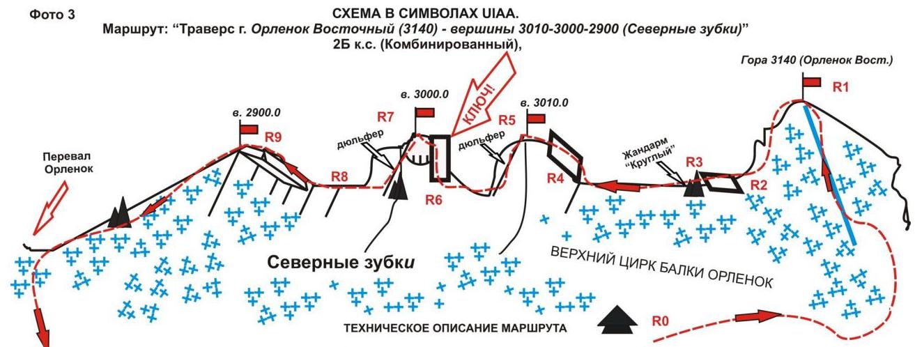
Route "Traverse of Orlenok Eastern peaks (3140.0 – 3010.0 – 3000.0 – 2900.0 (Severnye zubki) from northwest to southeast)"
Category — 2B (combined). Leader: V. Babkin. Western Caucasus, Orlenok gully, Karadzhash ridge. Section in KMGV — 2.1. E-mail — ZHUR58@RAMBLER.RU
Report
On the first ascent of the alpinist route "Traverse of Orlenok Eastern peaks — 2900, 3000, 3010 (Severnye zubki) from northwest to southeast" 2B category (combined), made on the annual alpinist event "Championship and primacy of NP 'Club of Northern Travels 'Sauk-Pa' 2012" (class "First ascents").
Region: Karachay-Cherkess Republic. Mountain country: Western Caucasus. Valley: Orlenok gully. Ridge: Karadzhash mountain massif. Peaks:
- Orlenok Eastern (3140.0)
- 3010.0
- 3000.0
- 2900.0 (Severnye zubki) Route: "Traverse of Orlenok Eastern peaks (3140.0 — 3010.0 — 3000.0 — 2900.0 (Severnye zubki)) from northwest to southeast"
Complexity level: 2B category (Combined) Prepared by: V. Babkin, S. Zhuravlev May, 2012

R0–R1 — ascent to Orlenok peak via 1B category route on the western slope and southeastern ridge. Snow slope. Length — 500 m. Steepness — 45°. Complexity level — 1 category. Simultaneous movement, self-belay with axe. Hooks/placements used — 0/8.
R1–R2 — descent to the ridge and transition under the "Round" gendarme. Snowy ridge. Length — 700 m. Steepness — 10°. Complexity level — non-categorical. Simultaneous movement with self-belay using axe. Hooks/placements used — 0/8.
R2–R3 — passage of an inclined wall and ascent to the "Round" gendarme. Length — 50 m. Steepness — 45°. Complexity level — 2+ category. Movement with alternating belay. Hooks/placements used — 2/1. Left — 0/8.
R3–R4 — passage of the ridge under the 3010 peak (third rock tower). Length — 200 m. Steepness — 20°. Complexity level — 2+ category. Simultaneous movement on a shortened rope, with mutual belay, on some sections — with alternating belay. Hooks/placements used — 0/8.
R4–R5 — rock wall — 50 m. Ascent to the 3010 peak (third rock tower). Length — 30 m. Steepness — 55°. Movement with alternating belay.
R5–R6 — rappel to the saddle. Length — 40 m. Steepness — 60°. Complexity level — 3+ category. Descent with rope retrieval. Hooks/placements used — 2/8. Left — 0/8.
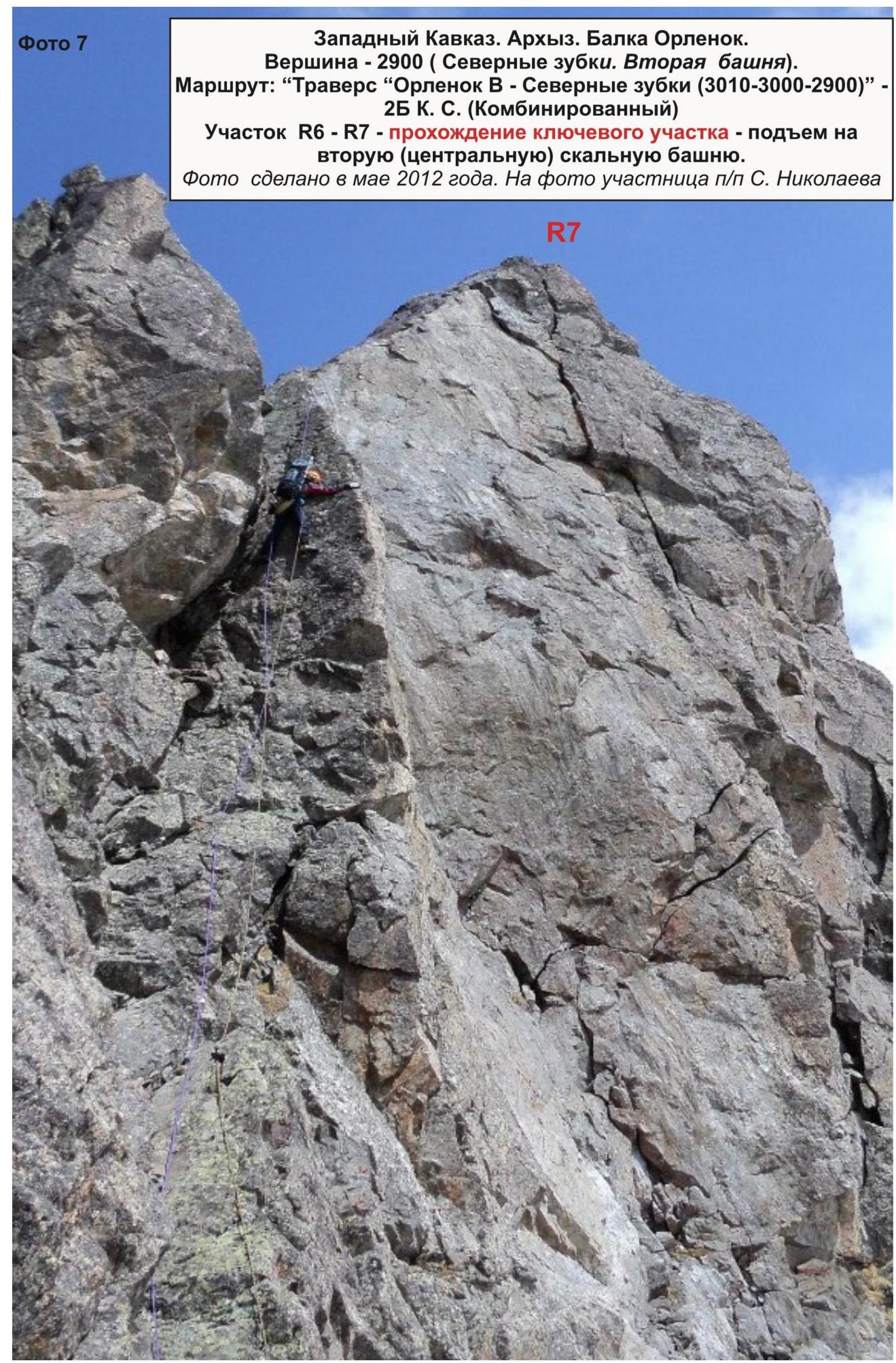
R6–R7 — ascent to the 3000 peak (second rock tower). KEY PART OF THE ROUTE! Length of the first section — 25 m (leftward movement) — 65°, 4 category. Then — 5 m — 80°, 5 category. And 10 m — 45°, 3 category (see the passage scheme). Hooks/placements used — 6/4. Left — 1/1.
R7–R8 — rappel to the saddle. Length — 45 m. Steepness — 80°. Complexity level — 3+ category. Descent with rope retrieval.
R8–R9 — ascent to the 2900 peak (first rock tower) — rock slope, wide, weakly expressed internal angle. Length — 200 m. Steepness — 25°. Complexity level — 1–2 category. Simultaneous movement on a shortened rope with mutual belay. Hooks/placements used — 0/8.
Descent via a snowy slope to the Orlenok pass, then — to the Orlenok and Sofia rivers valley to the base camp.
Peak description
Peaks — Orlenok Eastern (3140 m), 3010 m (third tower), 3000 m (second (central) tower), 2900 m (first tower) — general name — Severnye Zubki — are a series of peripheral peaks of the northwestern spur of the Karadzhash mountain massif (on old maps — Karadzhash ridge). Located in the Karachay-Cherkess Republic, North Caucasus Federal District, Russian Federation, between the Psyish and Sofia rivers, northwest of the Orlenok pass.
The nodal peak of the northwestern spur is Orlenok Eastern 3140.0, not visible from the Taulu glade, but clearly expressed from the Psyish river valley, from the confluence of the Belaya river into Psyish.
The peak does not have an official name.
The unofficial name — Orlenok Eastern — was given by alpinists to identify the peak, and the peaks of the northwestern spur of the Karadzhash ridge (2900.0, 3000.0, 3010.0) — the name Severnye Zubki — were given by geologists working in the Psyish river valley.
Route description
Route — "Traverse of Orlenok Eastern peaks (3140.0) — 2900.0, 3000.0, 3010.0 (Severnye Zubki) from northwest to southeast" — is a combined training route of 2B category, with a full range of natural obstacles corresponding to routes of this level.
This route does not meet the standard for training-sport routes of 2B category (there are sections of 4–5 category), so it can be recommended only for sports groups and training-sport sections of climbers with good rock climbing skills.
Equipment
To complete the ascent as part of a training-sport section of 6 people (5 participants + instructor), the following special equipment is required on the route:
Personal:
- standard equipment
- crampons
- ice axe
Group:
- main rope 10 mm — 3×50
- rock hammer — 2 pcs
- rock hooks — 8 pcs
- ice axe — 1 pc.
- placements — 12 pcs
- ice screws — 0 pcs
- slings — 10 pcs
- loops — 10 pcs
Approach
The ascent is made from a bivouac in the upper cirque of the Orlenok gully. The approach to the bivouac is not complicated: from the Taulu glade — the base camp location, cross the Sofia river by bridge and ascend the Orlenok gully — first along a forest road, then along a well-trodden trail.
The upper cirque is formed by the eastern slopes of the northern spur (ridge with a series of unexpressed peaks to the Orlenok pass) and the western slopes of the Karadzhash ridge (from the Orlenok rock to the Orlenok pass).
The cirque is clearly expressed, snowy in winter and spring, with two beautiful lakes among small birch and pine groves in summer.
The height of the upper cirque of the Orlenok gully is 2200 m above sea level.
The ascent to the upper cirque from the Taulu glade takes 1.5–2 hours.
The cirque has convenient places for a bivouac, with:
- water (streams),
- firewood,
- dry areas, freed from snow in late April — early May.
Technical part
The route begins with an ascent to the Orlenok Eastern peak via a 1B category route on snowy slopes. At the foot of the Orlenok Eastern peak, it is convenient to organize rope teams. The approach to the foot of the peak from the bivouac takes 1–1.5 hours.
The ascent to the peak via snowy slopes of medium steepness — 30–45 degrees — is not problematic for climbers, but one should not forget about the potential avalanche danger of such slopes. The peak is dome-shaped with a rocky area on top. The cairn is easily found.
From the Orlenok Eastern peak (3140.0), descend to the ridge and approach the "Round" gendarme.
The ascent to the "Round" gendarme is the first technically complex section of the route. It is made via an inclined rocky slab "en face".
Then:
- descent from the "Round" gendarme to a simple snow- and rock-filled ridge;
- a long approach under the base of the 3010.0 peak — the third rock tower of Severnye Zubki.
The ascent to the peak via an inclined rocky wall is of medium complexity. During the ascent, standard stopper placements are used for intermediate belay points.
The peak is pyramidal with a small area, allowing a sports group to gather.
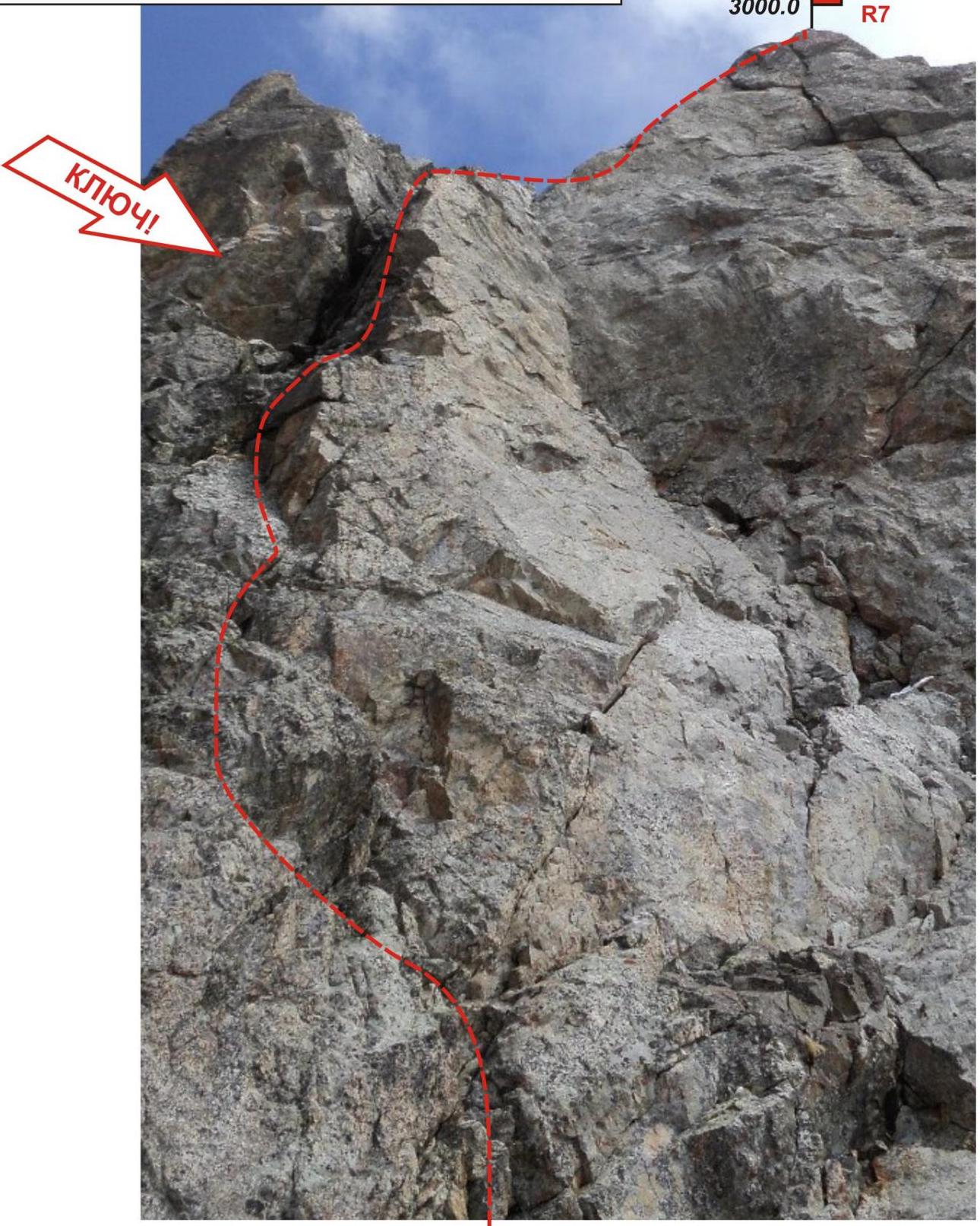
Then — a rappel from the peak to the saddle. The saddle is a short rocky ridge. Along this ridge, approach the base of the 3000.0 peak (second (central) rock tower of Severnye Zubki). The ascent to this tower is the key part of the route.
Key part of the route: A clearly expressed crack with a plug in the upper part.
Characteristics of the key section:
- 25–30 m of climbing on monolithic rocks, 4 category;
- passage of the plug in the upper part — very difficult climbing — 5 m, 5 category;
- 10–35 m of rocky ridge, 3 category;
- the peak is pyramidal;
- the cairn on the peak is easily found.
Then — a rappel to the saddle between the 3000.0 peak (second (central) tower) and the 2900.0 peak (first tower) of Severnye Zubki.
From the saddle, along a destroyed rocky ridge, approach the 2900.0 peak (first tower) of Severnye Zubki and ascend to the peak via a rocky ridge of 2B, 3B category or a weakly expressed wide internal angle. On the ridge, there are many convenient ledges for organizing intermediate belay. The peak is pyramidal, easily identified.
The descent from the 2900.0 peak (first tower of Severnye Zubki) to the Orlenok pass is not difficult, as it goes along a simple snowy slope.
Descent from the peak
Descent from the peak via a trail from the Orlenok pass, going along a stream, forming the Orlenok river. Then, along the left bank of the Orlenok river to the base camp.
Recommendations for the instructor
To reduce the time spent on the ascent, it is advisable to conduct additional rock climbing training with participants before the ascent, as the presence of sections of 4–5 category on a 2B route requires identifying a lead rock climber capable of climbing complex rocks in crampons if necessary. Additional training is also necessary to practice the following skills:
- organizing a rappel descent;
- rope retrieval.
If the weather worsens during the route, the key section becomes difficult or impassable, so it is better to abandon the route and return to the base camp via the Orlenok Eastern peak (3140.0).
Passport
- Section number according to KMGV — 2010 — 2.1
Western Caucasus, Arkhyz mountain region, Orlenok gully, Karadzhash mountain massif.
- Peak names: Orlenok Eastern (3140) — 3010.0, 3000.0, 2900.0 ("Severnye Zubki").
- Height: 3140.0, 3010.0, 3000.0, 2900.0.
- Route: "Traverse of Orlenok Eastern peaks (3141.0), 3010.0, 3000.0, 2900.0 (Severnye Zubki) from northwest to southeast".
- Category: 2B
- Route character — combined.
- Height difference on the route: 940 m.
- Route length: 1680 m.
- Length of sections with the highest category:
1 category — 5 sections — 725 m, 2 category — 3 sections — 180 m, 3 category — 3 sections — 140 m, 4 category — 1 section — 25 m, 5 category — 1 section — 5 m, 6 — 0 m.
- Average steepness: main part of the route — 55 degrees.
total route — 45 degrees.
-
Equipment used on the route:
- rock hooks — 18 pcs.
- placements — 20 pcs.
- stationary pitons — 0
- ITO — 0
- removable pitons — 0. Hooks left on the route: total — 3 pcs., placements left: 1 pc.; including pitons — 0.
-
Departure on the route — 6:00, May 3, 2012.
Ascent to the peaks:
- Orlenok Eastern (3140.0) — 8:00
- 3010.0 (third tower of Severnye Zubki) — 12:00
- 3000.0 (second (central) tower of Severnye Zubki) — 13:00
- 2900.0 (first tower of Severnye Zubki) — 14:00.
Return to the base camp — 16:00, May 3, 2012.
- Team's total hours: — 11 hours.
- Leader: Vyacheslav Babkin (CMS, instructor-methodologist of 3rd category, Yekaterinburg).
Participants: E. Ermakov (3rd sports category, Voronezh), S. Nikolaeva (3rd sports category, Voronezh).
- Coach: Zhuravlev Sergey Vasilyevich, CMS, instructor-methodologist of 1st category.
R5–R1 — ascent to Orlenok peak via 1B category route on the western slope and southeastern ridge. Snowy slope. Length — 500 m. Steepness — 45°. Complexity level — 1 category. Simultaneous movement, self-belay using axe. Crampons/placements used — 0/8.
R1–R2 — descent to the ridge and transition under the "Round" gendarme. Snowy ridge. Length — 700 m. Steepness — 10°. Complexity level — non-categorical. Simultaneous movement with self-belay using axe. Crampons/placements used — 0/8.
R2–R3 — passage of an inclined wall and ascent to the "Round" gendarme. Length — 50 m. Steepness — 45°. Complexity level — 2+ category. Movement with alternating belay. Hooks/placements used — 2/1. Left — 0/8.
R3–R4 — passage of the ridge under the 3010 peak (third rock tower). Length — 200 m. Steepness — 20°. Complexity level — 2+ category. Simultaneous movement on a shortened rope, with mutual belay, on some sections — with alternating belay. Hooks/placements used — 0/8.
R4–R5 — rock wall — 50 m. Ascent to the 3010 peak (third rock tower). Length — 30 m. Steepness — 50°. Movement with alternating belay.
R5–R6 — rappel to the saddle. Length — 40 m. Steepness — 80°. Complexity level — 3+ category. Descent with rope retrieval. Hooks/placements used — 2/8. Left — 0/8.
R6–R7 — ascent to the 3000 peak (second rock tower). KEY PART OF THE ROUTE!
- Length of the first section — 25 m (leftward movement) — 65°, 4 category.
- Length — 5 m — 80°, 5 category.
- Length — 10 m — 45°, 3 category (see the passage scheme). Hooks/placements used — 6/4. Left — 1/1.
R7–R8 — rappel to the saddle. Length — 45 m. Steepness — 80°. Complexity level — 3+ category. Descent with rope retrieval. Hooks/placements used — 2/8.
R8–R9 — ascent to the 2900 peak (first rock tower) — rock slope, wide, weakly expressed internal angle. Length — 200 m. Steepness — 25°. Complexity level — 1–2 category. Simultaneous movement on a shortened rope with mutual belay. Hooks/placements used — 0/8.
Descent via a snowy slope to the Orlenok pass, then — to the Orlenok and Sofia rivers valley to the base camp.
Western Caucasus, Arkhyz, Orlenok gully.
Peaks:
- 3140.0 (Orlenok Eastern)
- 3010.0 (third tower)
- 3000.0 (second (central) tower)
- 2900.0 (first tower) — general name "Severnye Zubki"
Route: "Traverse of Orlenok Eastern peaks — 3010.0, 3000.0, 2900.0 (Severnye Zubki) from northwest to southeast" 2B (combined) (approximately) (table of natural obstacles on the route)
| Section | Length | Steepness | Relief character | Category | Hooks/placements |
|---|---|---|---|---|---|
| R0 — start of the route — "foot" of the peak: 3140.0 m (Orlenok Eastern) | |||||
| R0–R1 Ascent via a snowy slope to the 3140.0 peak (Orlenok Eastern) | 500 | 45 | Snowy slope | 1 | 0 / 0 |
| R1 — peak 3140 m (Orlenok Eastern) | |||||
| :--: | :--: | :--: | :--: | :--: | :--: |
| R1–R2 Descent to the ridge and approach under the "Round" gendarme | 700 | 25 m on (ridge — 10–15 m) | Snowy slope | 1, N/C | 0 / 0 |
| R2–R3 Ascent to the "Round" gendarme | 50 | 45 | Rock slab | 2+ | 0 / 4 |
| R3–R4 Passage of the ridge, approach under the base of the 3010.0 peak (third tower) of Severnye Zubki | 200 | 20 | Rocky ridge | 1, upper part — 2 category | 6 / 12 |
| R4–R5 Ascent to the 3010.0 peak — third tower of Severnye Zubki. | 50 | 55 | Inclined wall | 2+ | 2 / 0 |
| R5 — peak 3010.0 (third tower of Severnye Zubki) | |||||
| R5–R6. Rappel to the saddle and transition under the base of the 3000 peak (second (central) tower of Severnye Zubki). | 40 | 60 | Wall | 3+ | 2 / 0 |
| R6–R7. Passage of the rock wall of the 3000.0 peak (second (central) tower of Severnye Zubki). (KEY PART OF THE ROUTE!) | 25 5 10 | 80 95 40 | Wall, rocky monolith, crack with a plug to the left of the internal angle (do not climb into the angle | 4+ 5− 3+ | 6/4 left 1/1 |
| R7 — peak 3000.0 (second (central) tower of Severnye Zubki). | — it's a fake!) | ||||
| R7–R8. Rappel to the saddle, approach to the base, and ascent to the 2900.0 peak (first tower of Severnye Zubki). | 100 | 40 100 80 | Rappel, destroyed rocky ridge, weak | 3+ 1 2+ | 2 / 0 left 2/0 |
| expressed internal angle. | |||||
| :-- | :-- | :-- | :-- | :-- | :-- |
| R8 — peak 2900.0 (first tower of Severnye Zubki) | |||||
| Descent via the western ridge to the Orlenok pass. | 200 | 25 — 15 | Snowy slope | 1, N/C |
Total
Route length — 1680 m. Average steepness — 55°. Relief character — combined.
Sections:
- 1 category — 5 sections — 725 m
- 2 category — 3 sections — 180 m
- 3 category — 3 sections — 140 m
- 4 category — 1 section — 25 m
- 5 category — 1 section — 5 m
Hooks and placements used: 18 (20), left: 3 (1)
Western Caucasus. Arkhyz. Orlenok gully. Peaks of Severnye Zubki — 3010 (Third tower) and 3000 (Second (central) tower).
Route: "Traverse 'Orlenok V — Severnye Zubki (3010–3000–2900)' — 2B category (combined).
Main photo
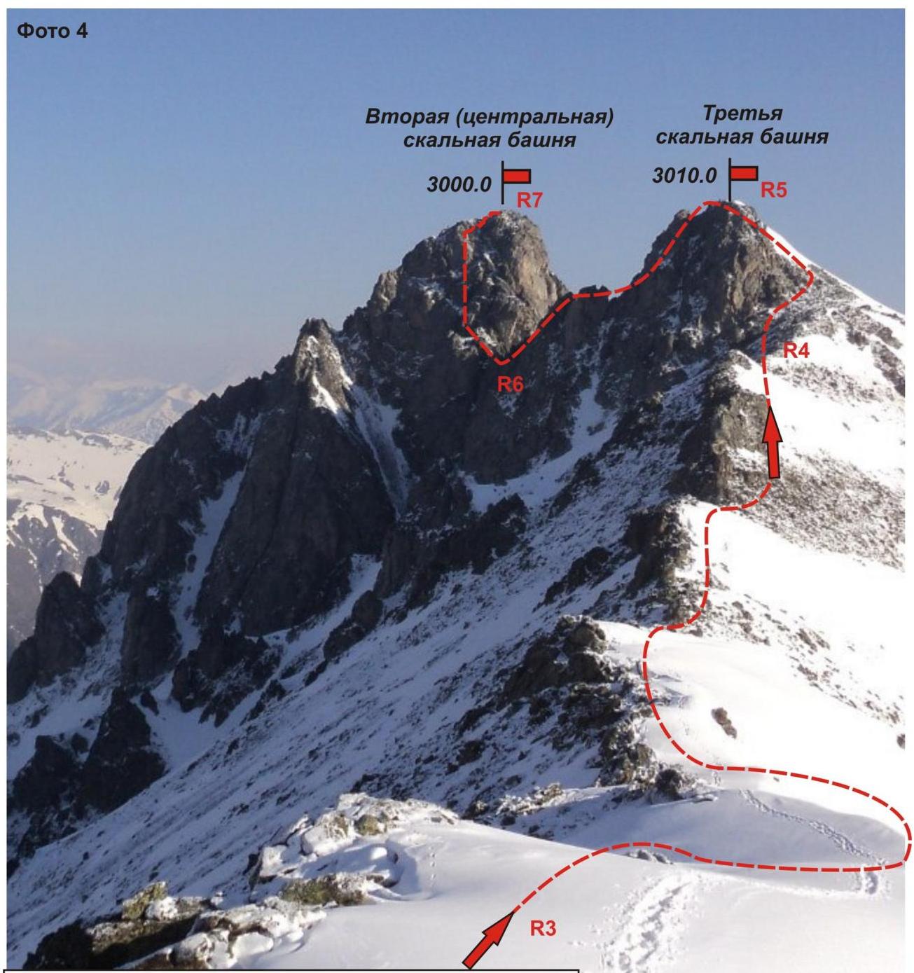
Sections:
- R3–R4 — passage along the ridge from the "Round" gendarme to the base of the third rock tower.
R4–R5 — ascent to the third tower. R5–R6 — rappel to the saddle. R6–R7 — ascent to the second (central) rock tower (KEY!).
Section R2–R3 — ascent to the "Round" gendarme.
Photo below. Taken in May 2012.
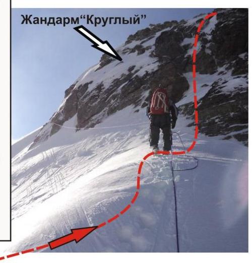
Photo 6
Western Caucasus. Arkhyz. Orlenok gully. Peak — 3000 m (Severnye Zubki. Second (central) tower). Route: "Traverse 'Orlenok V — Severnye Zubki (3010–3000–2900)' — 2B category (combined). Section R6–R7 — wall with a crack on the second (central) rock tower — KEY PART OF THE ROUTE. Taken in May 2012.
Second (central) rock tower.
□
□
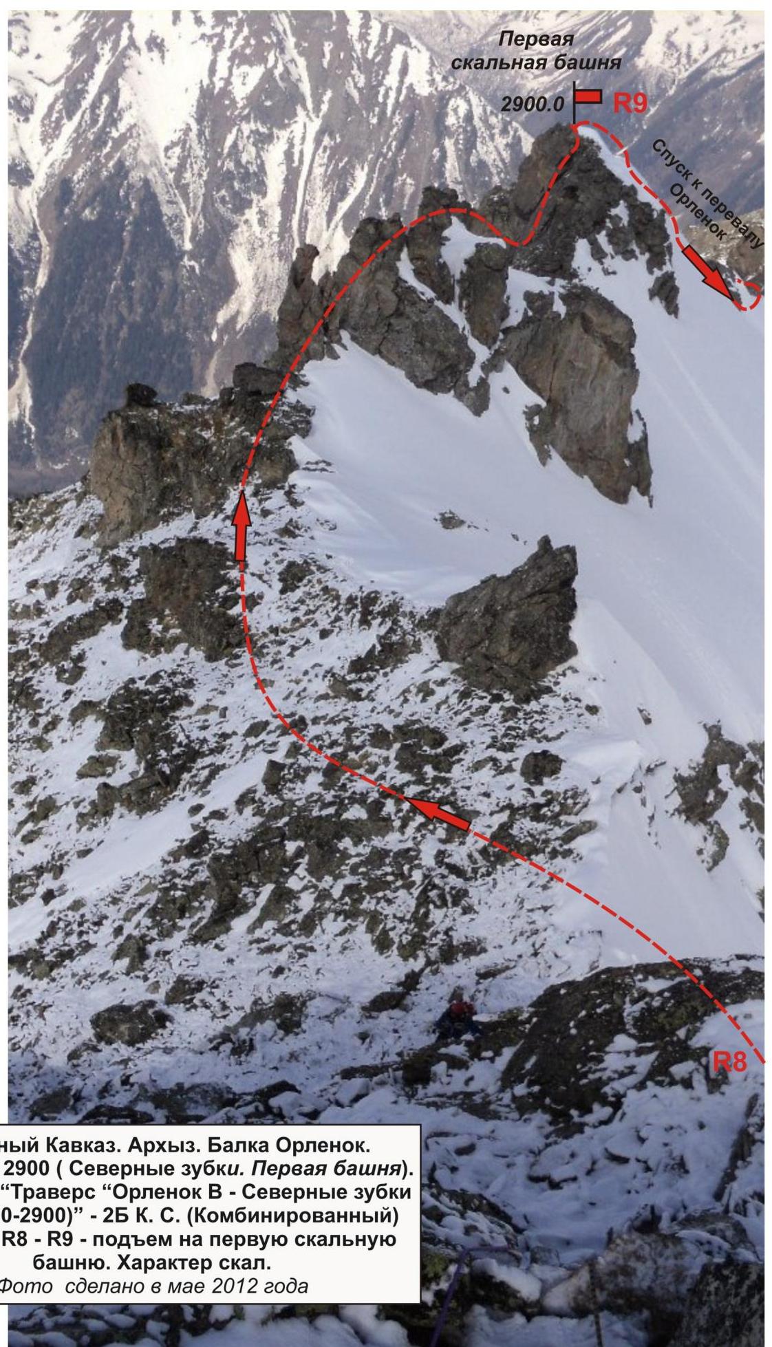
Western Caucasus. Arkhyz. Orlenok gully. Peak — 2900 m (Severnye Zubki. First tower). Route: "Traverse 'Orlenok V — Severnye Zubki (3010–3000–2900)' — 2B category (combined). Section R8–R9 — ascent to the first rock tower. Rock character. Taken in May 2012.


