ASCENT PASS
- ASCENT CLASS — rock
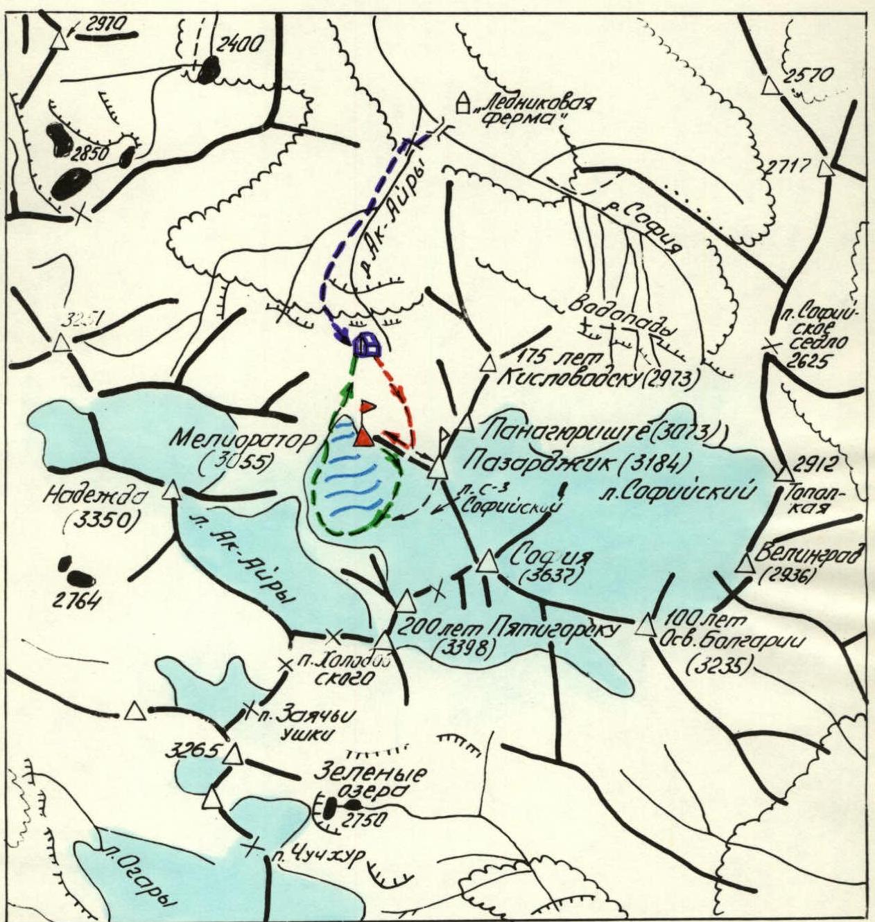
- ASCENT REGION — Western Caucasus, Arkhyz, Soffiy Range between the upper reaches of the Sofia and Ak-Airy rivers
- PEAK, ROUTE — peak "MELIORATOR" (proposed by the first ascenders), 3055 m via the North couloir and East ridge
- PROPOSED DIFFICULTY CATEGORY — 2A
- ROUTE CHARACTERISTICS — combined, via a snow-ice couloir and a rocky ridge, height difference 460 m, average slope — 45°, ridge — 25°
- HOOKS DRIVEN IN — 3 ice screws, 2 rock pitons
- TRAVEL TIME — about 8 hours
- NUMBER OF NIGHTS — not required on the route
- ASCENT LEADER — Zaporizhchenko E.V. — Candidate Master of Sports, instructor
- PARTICIPANTS Gavrilov I.V. — 1st category Smerchansky V.A. — 1st category Sokolenko I.N. — II category Sokolov A.V. — II category
- TEAM COACH — Master of Sports of the USSR Popov V.P.
- DATE OF DEPARTURE AND RETURN — September 11, 1981
4552
Legend:
- Path to the base camp
- Path to peak "Meliorator" (≈28 km)
- Descent path from peak "Meliorator"
- Path to peak "Pazardzhik" (≈26 km)
- Descent path from peak "Pazardzhik"
- Base camp location
The ascent to the previously unnamed peak was made on September 11, 1981, during the "Arkhyz-81" event organized by the Stavropol Regional Sports Committee.
The ascent was preceded by thorough reconnaissance carried out by the Stavropol Regional Federation of Mountaineers: in autumn 1979, spring 1980, and July 1980, when the climbers made first ascents to the peaks "200 years of Pyatigorsk" and "Panagyurishte" (reconnaissance of paths from the North and West), and in October 1980, when a route from the East to the neighboring unnamed peak was scouted.
The simplest initial path from the North, via a snow-ice couloir separating the massif of peak "Meliorator" from the massif of the unnamed peak to the East, and then along the East ridge, was considered the most feasible.
To the northwest and south, the massif of peak "Meliorator" drops off with slopes of average steepness:
- ≈85° (northwest wall),
- ≈75° (west edge),
- ≈65° (southern, ruined walls).
To the south and west, the peak is contoured by the randklufts of the "NW Sofia" glacier. In close proximity, separated by the mentioned glacier, lies the peak Sofia — the highest point in the area (3637.4 m).
Peak "Meliorator" dominates the steep and broken tongue of the "NW Sofia" glacier. It is marked on all topographic maps and has an absolute height of 3055 m according to the latest 1:25,000 scale plans. Nearby mountaineering objects and routes:
- peak "175 years of Kislovodsk" — category 1B, absolute height 2973 m;
- peak "Velingrad" — category 3B, absolute height 2936 m;
- peak "Panagyurishte" — absolute height 3073 m (category 2B, climbed but not yet classified);
- peak "200 years of Pyatigorsk" — category 1B, absolute height 3398 m;
- peak Sofia — category 3.
The group of climbers did not find any signs of human presence on peak "Meliorator" — the summit cairn was built by them for the first time. A possible explanation for this is the apparent complexity of the ascent, which, however, only delayed the inevitable first ascent to the peak as part of the planned mountaineering exploration of the area by the Regional Federation.
The first ascent to peak "Meliorator" was made by a group of Stavropol climbers — employees of the "Sevkavgiprovodhoz" design institute under the Ministry of Land Reclamation and Water Management of the RSFSR.
The initial bivouac was set up on a flat area above the last (upper) belt of "ram's foreheads" (rock formations), from which the Ak-Airy river flows. The path to the bivouac from the "Glacier Farm" on the Sofia river (absolute height 1920 m), taking about 3 hours, was described in the report on the first ascent to peak "200 years of Pyatigorsk". It starts from a wooden bridge over the mouth of the Ak-Airy river, slightly above its confluence with the Sofia river, and goes along the left (orographic) slopes of the valley of this river towards the amphitheater of steep rocks, from which a series of beautiful waterfalls cascade in the second half of summer.
Further, the route:
- turns left (in the direction of travel);
- traverses with an ascent on grassy slopes;
- ascends to the "ram's foreheads";
- then — to the right along the "foreheads", with a steep ascent up to a flat area in a moraine rubble.
Here — the bivouac. The area is not free of snow until the end of July, and not every year.
Landmarks from the bivouac (looking south):
- straight ahead — the northwest wall of peak "Meliorator";
- to the right, in the distance — the northwest buttress of peak "200 years of Pyatigorsk";
- to the left — peak "Pazardzhik" (proposed name);
- peaks "Panagyurishte" and "175 years of Kislovodsk" (photo 1).
From the bivouac to the start of the route, there is a short 150-meter approach across a snow-filled depression with a very slight ascent. The direction is towards the middle part of the northwest wall of the peak (the wall is somewhat rotated to the west, more precisely, it has a northwest exposure). Under the wall (2595 m) is the start of the route.
Route Description
Section R0–R1. (see table, photo 2). Upwards to the left, in rope teams, across a snow slope with a slope of about 30° to the left, northeast edge of the wall. The snow is hard and dense in the morning, movement is on crampons. Beyond the edge is the mouth of the couloir. 2675 m.
Section R1–R2. The entire section is a steep snow-ice couloir. It should be called a couloir only as a courtesy to mountaineering terminology. In fact, it is a large fault cutting through the massif of granite gneisses and granites. The walls of the fault-couloir are close to vertical: on the left (in the direction of travel) they are composed of granite gneisses, on the right — predominantly granites. The width is up to 15 m. The fault-couloir is filled with ice, on which a compacted snow cushion is held. Movement is on crampons, alternating, with insurance via an ice axe (obviously, only in the first half of summer) and via ice screws. The group used ice screws three times in places where the snow cover was thinning for insurance (insurance via rock pitons on the couloir walls is less convenient).
Steepness:
- At the beginning — ≈40°
- From a point with an absolute height of 2775 m — ≈45°
From this point, the "Sloping Gendarme" on the saddle is clearly visible ahead (photo 3). It is safest to move while sticking to the right (in the direction of travel) side of the fault-couloir.
The "Sloping Gendarme", to which the fault-couloir leads, divides the saddle into two depressions. The right one is the lowest. Absolute height — 2925 m.
From the saddle, there is a view of the northern slopes of peak Sofia. Below is the glacier. On the saddle, a control cairn is built. No signs of human presence were found.
From the saddle:
- To the right — a narrow ridge (photo 4) to peak "Meliorator", representing a combination of dips and low walls;
- To the left of the "Sloping Gendarme" — the wall of the west ridge of the unnamed peak with an absolute height of 3184 m (according to a 1:25,000 scale state survey map).
Time taken to reach the saddle from the start of the route — 3.5–4 hours.
Section R2–R3. The gain in height along the ridge is not great ≈130 m, but the ridge is very jagged. Movement is alternating:
- first to the left in the direction of travel, sometimes holding onto the ridge with hands;
- and 1–1.5 rope lengths before the summit — a transition to the right side.
There is no need for piton insurance — there are many ledges and sharp "micro-gendarmes". The degree of destruction is significant,
 one should move carefully. The summit is composed of granites with quartz veins. Absolute height — 3055 m. No signs of human presence until September 11, 1981. From the saddle to the summit — 1.5 hours. The cairn is built for the first time (photo 5). Descent is only via the ascent path to the saddle:
- to the west from the summit cairn, a steep edge immediately descends into the glacier zone (photo 6);
- to the north — after a short slope — a vertical wall;
- to the south — a steep, ruined slope consisting of wall-steps.
Section R3–R4. Reverse movement along the ascent path to the "Sloping Gendarme" (photo 7).
Section R4–R5. From the saddle, two rappels of 35 m and another 80 m with alternating insurance down to the south, onto the "NW Sofia glacier" (photo 8). The wide randkluft was covered by snow bridges at this time of year. At another time and in another year, the randkluft may prove difficult to cross, and it may be more advisable to return via the ascent path, i.e., via the northern fault-couloir. Further movement is along the glacier, bypassing the peak with an exit under the slopes of peak "200 years of Pyatigorsk", in order to descend onto the moraines of the Ak-Airy glacier along the relatively gentle part of the "NW Sofia glacier" (photo 9). Observations in 1980 and the circumvention of the peak on September 11, 1981, showed that ascents from the south and west to peak "Meliorator" are more complex.
The ascent from bivouac to bivouac took the group 8 hours. At the debriefing conducted in the presence of the event organizer, head of rescue services, and participants, the first ascent was assessed as corresponding to a combined route of category 2A.
Recommendations
- Group size — 4–6 people.
- It is necessary to have 3–4 ice screws and 2–3 rock pitons.
- Main ropes for descent via rappel or dülfer on the south side should be 40 meters long.
Leader E.V. Zaporizhchenko
Pyatigorsk, September 30, 1981
Table
Main Characteristics of the Ascent Route to Peak "Meliorator"

| Date | Section | Steepness, ° | Length, m | Terrain Characteristics | Difficulty | Condition | Weather Conditions | Rock Pitons | Ice Screws | Bolts |
|---|---|---|---|---|---|---|---|---|---|---|
| 11.09.81 | R0–R1 | 30 | 190 | Snow slope | P+ | Compacted hard snow | Clear | |||
| R1–R2 | 45 | 480 | Snow-ice couloir | P+ | Compacted hard snow on ice substrate, in places thinner than necessary for insurance via ice axe | — | 3 | |||
| " | R2–R3 | 30 | 310 | Sharp ridge with numerous dips | P | Average degree of weathering and destruction | — | |||
| " (Descent) | R3–R4 | 30 | 210 | Sharp ridge with numerous dips | P+ | Average degree of weathering and destruction | — | |||
| " (Descent) | R4–R5 | 75 | 150 | Steep, step-like slope | P+ | High degree of destruction | — | 2 |