Ascent Passport
| ASCENT CLASS | — rock climbing |
|---|---|
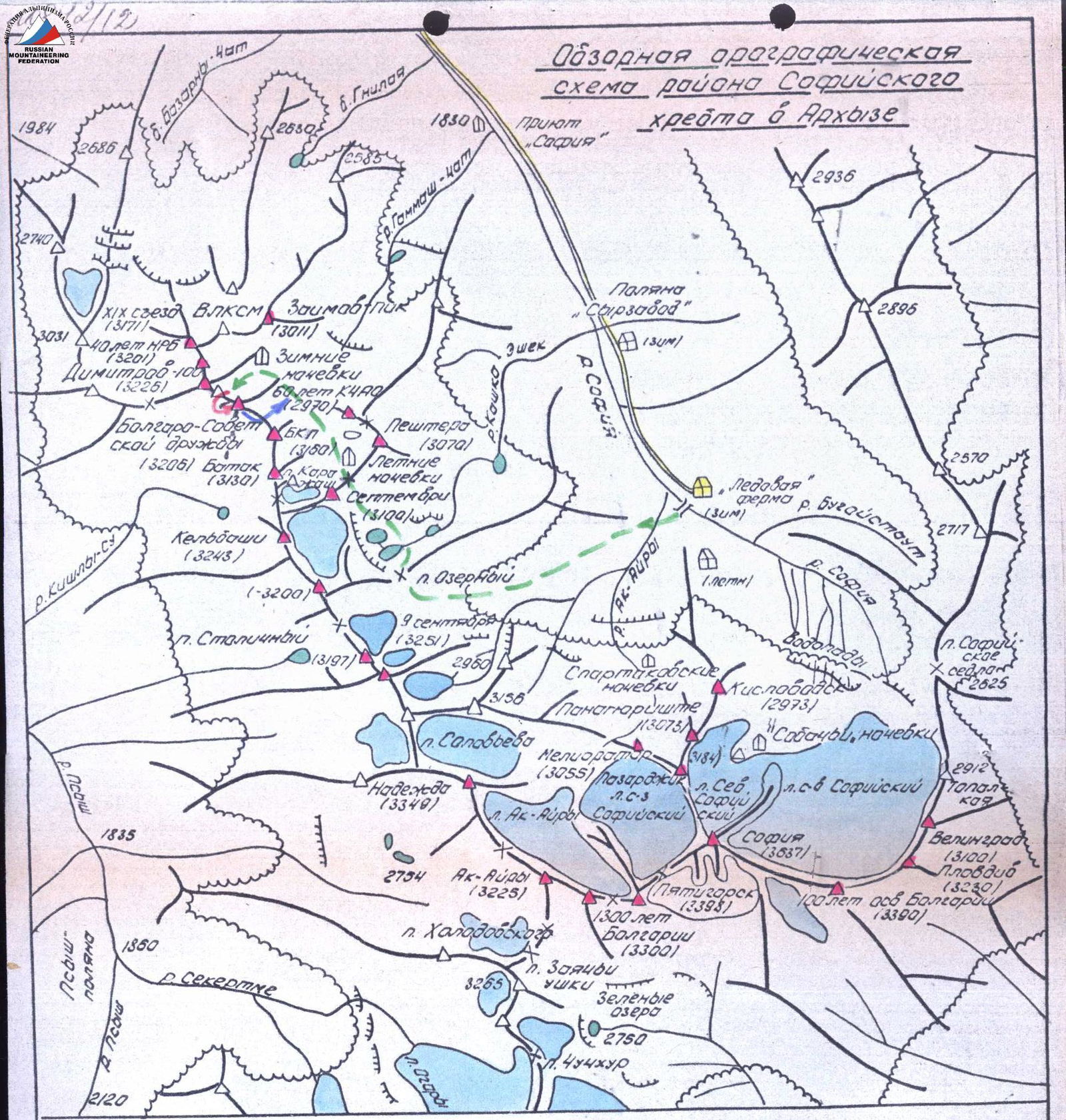
| ASCENT AREA | — Western Caucasus, North-West spur of the Sofiyskiy ridge between the Pshish and Sofia river valleys |
| PEAK, ROUTE | — Bolgaro-Sovetskoy druzhby (BSD) via the Northern slope and South-Western counterfort |
| ASSUMED DIFFICULTY CATEGORY | — 2B |
| ROUTE CHARACTERISTICS | — rock climbing, absolute height difference ~ 300 m |
| NUMBER OF PLACED PROTECTION | — II |
| NUMBER OF CLIMBING HOURS | — 4 h (from the start of the route to the summit) |
| NUMBER OF NIGHTS | — no overnight stays required on the route |
| LEADER AND PARTICIPANTS | — Zaporozhchenko E.V., CMS Bobylyov V.D., 2nd sports category |
| OBSERVERS | — Roshchin Yu., 1st sports category Pishchev V., 2nd sports category |
| TEAM COACH | — Damianiudi I., MS |
| DATE OF DEPARTURE AND RETURN | — October 2, 1985 |
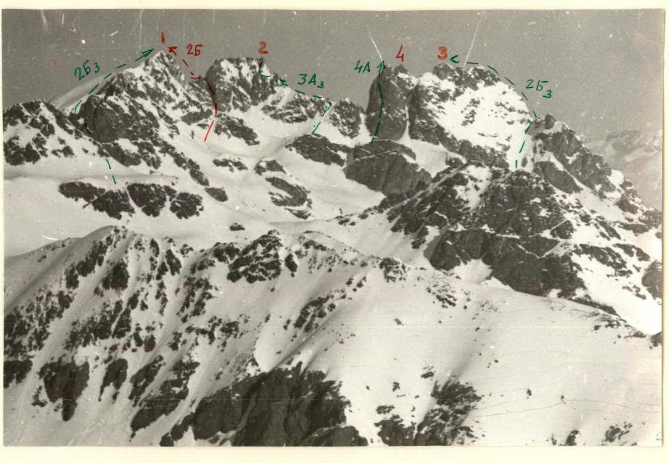
Photo 1. General view.
- 1 — BSD
- 2 — Dimitrov-100
- 4 — 40 лет НРБ
- 3 — XIX съезд ВЛКСМ
→ 25 classified routes.
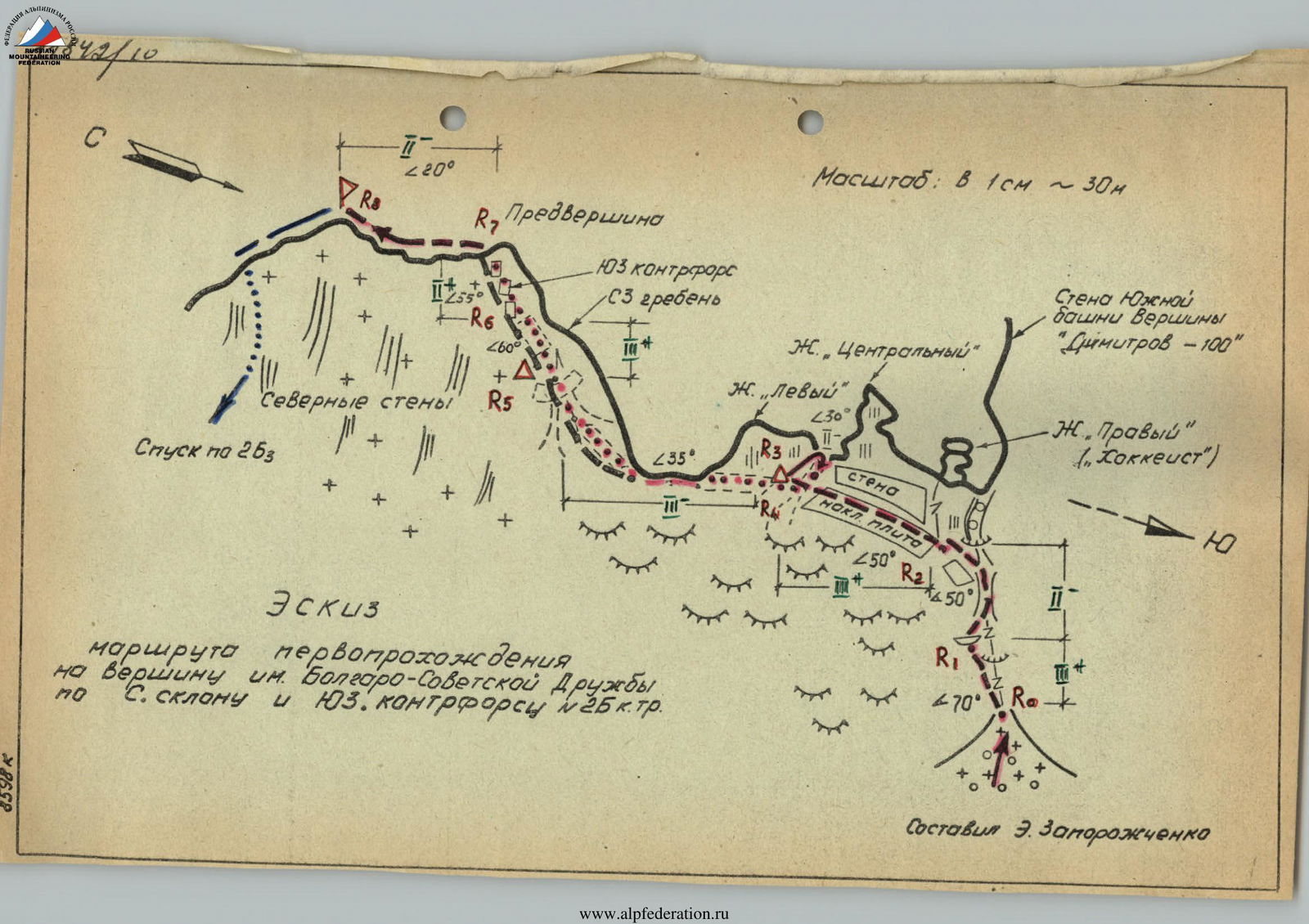
Scale: 1 cm ≈ 30 m
Compiled by E. Zaporozhchenko
Team composition
Numerical designation
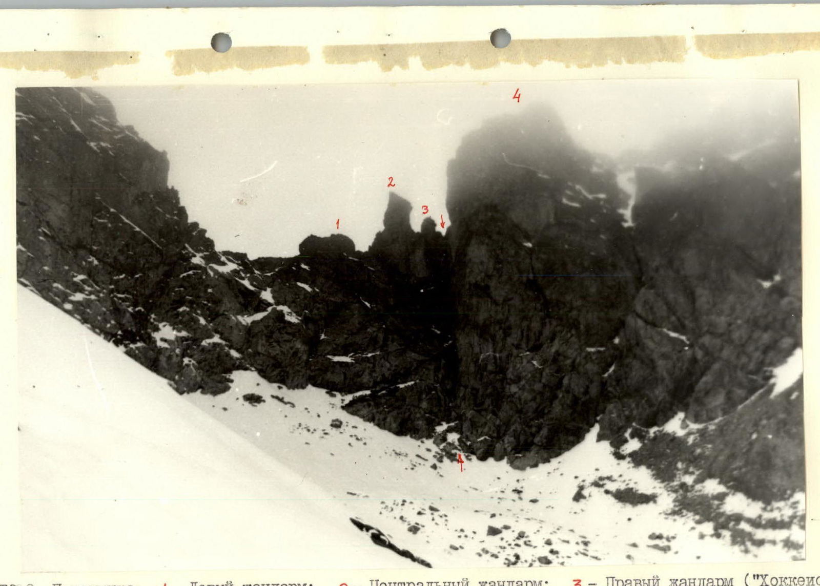
Photo 2. Saddle.
- 1 — Left sentinel
- 2 — Central sentinel
- 3 — Right sentinel («Hockey player»)
- 4 — South tower «Dimitrov-100»
→ ← — Cleft October 2, 1985
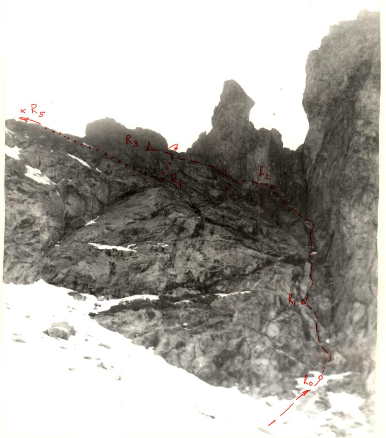
Photo 3. Section of the route from R0 to R4 and partly R4–R5. October 2, 1985. The path to the base camp by the lakes under the peak «60 лет КЧАО» (from the south) has been previously described (see also the «Scheme»). The path to the start of the route partially coincides with the similar path to route ЗАз on the peak «Dimitrov-100» (3226 m, #57 of Section 2.I of the classification table). From the base of the ascent via ЗАз, 90° left and up the snow, L = 30° ~ 400 m in the direction of the saddle between the peaks Bolgaro-Sovetskoy druzhby (3205 m) and South tower of the peak «Dimitrov-100» (Photo 1). There are three sentinels on the saddle: Left (trapezoidal), Central (the highest), and Right («Hockey player»). The Right sentinel is actually beyond the saddle, and from below it appears to be in line with the first and second sentinels. The direction should be held towards the junction of the saddle wall and the wall of the South tower, to which a cleft descends from under the «Hockey player» sentinel (Photo 2). Start of the route! From the overnight stay by the lake — 2–2.5 h.
Route description
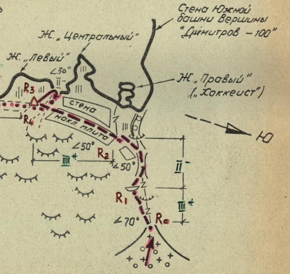
SECTION R0–R1 (Photo 3). Along the left part of the cleft (smoothed granite-gneiss) ~35 m to a convenient reception point (flake, shelter), bypassing a нависание on the left in the last third of the section, with an exit above it, 70°. 3 protection placements. Cat. difficulty 3.
SECTION R1–R2 (Photo 3). Up the gradually widening cleft (65 m, L = 50°, 3) with an exit to the wall of the Central sentinel along the smoothed inclined rocks. 2 protection placements. After 35–40 m, the cleft turns into a vertical complex couloir with jams and нависаниями. It remains to the right of the route.
SECTION R2–R3 (Photo 3). Left and up along the wall of the Central sentinel under the wall of the Left sentinel, 50 m. Here is a control cairn! 3 protection placements, L = 45°, 3. 5 m to the right and up is the saddle between the Left and Central sentinels. From it, a scree couloir descends to the south.
SECTION R3–R4. Straight down the couloir (30 m, L = 30°) to the first ledge, allowing to bypass the Left sentinel from the south with an exit to the lowest point of the saddle. Bypass ~ 90 m. 1.
SECTION R4–R5. From the top, a fairly wide snow-covered couloir descends to the south side of the saddle (Photo 4), divided across by several smoothed walls 2–5 m high. This couloir, in turn, separates the North-Western ridge and the South-Western counterfort (Photo 5), converging on the pre-summit.
Along the ledges to the right and up, in the direction of the lower bifurcation of the couloir:
- ~30 m, L = 30°.
From the bifurcation, a ledge goes to the right, following which:
- ~60 m under L = 40° — exit to a fairly wide rocky (snow-covered in October 1985) area.
From it:
- 15 m to the right and up — South-Western counterfort (more precisely, WSW). 1. Protection — behind the ledges. 2nd control cairn!
SECTION R5–R6. 10 m along the counterfort to the right, traversing, is a large rock flake (Photo 6). Through it to the south side of the counterfort ~15 m. Further, 40 m to the left and up along the smoothed plate-like rocks to the ridge part of the counterfort. This part has a steepness of 60–65°, cat. difficulty 3. 3 protection placements.
SECTION R6–R7. Along the stepped rocks with a steepness of initially 60–65°, then 40–45° ~60 m straight up to the pre-summit, 2.
SECTION R7–R8 (Photo 7). Along the easy ridge L = 20°, L = 70 m (simultaneous movement) to the summit, 1.
Descent via the winter route 2B cat. difficulty (along the South-Eastern ridge, #56 of Section 2.I of the classification table), to the saddle between the peaks Bolgaro-Sovetskoy druzhby and Bolgarskoy Kompartii and down, to the north, along the snow, to the screes and further to the base camp (option — to the south along the screes to Karauzhash pass).
Time to complete the route from R0 to R8 — 4 h. Assessment — rock climbing route 2B cat. difficulty.
Compiled in Pyatigorsk October 1985
Table of main characteristics of the first ascent route 2B cat. difficulty to the peak Bolgaro-Sovetskoy druzhby.
| Date | Characteristics of sections | Relief | Difficulty | Conditions | Protection | ||||
|---|---|---|---|---|---|---|---|---|---|
| Designation | Average steepness, ° | Length, m | Weather conditions | Rock | Placement | ||||
| 2.10.1985 | R0–R1 | 70 | 35 | Edge of cleft | 3 | Smoothed rocks | Variable cloudiness | – | 3 |
| R1–R2 | 50 | 65 | Cleft | 2 | Stepped rocks | Variable cloudiness | – | 2 | |
| R2–R3 | 45 | 45 | Steep slope | 3 | Smoothed rocks | Variable cloudiness | – | 3 | |
| R3–R4 | 30 | 120 | Couloir, ledges | 1 | Scree rocks | Variable cloudiness | – | – | |
| R4–R5 | 35 | 90 | System of ledges | 3 | Scree rocks | Variable cloudiness | – | – | |
| R5–R6 | 60 | 55 | Steep stepped slope | 3 | Smoothed rocks | Variable cloudiness | – | 3 | |
| R6–R7 | 55 | 60 | Steep stepped slope | 2 | Scree rocks | Variable cloudiness | – | – | |
| R7–R8 | 20 | 70 | Ridge | 1 | Scree rocks | Variable cloudiness | – | – |
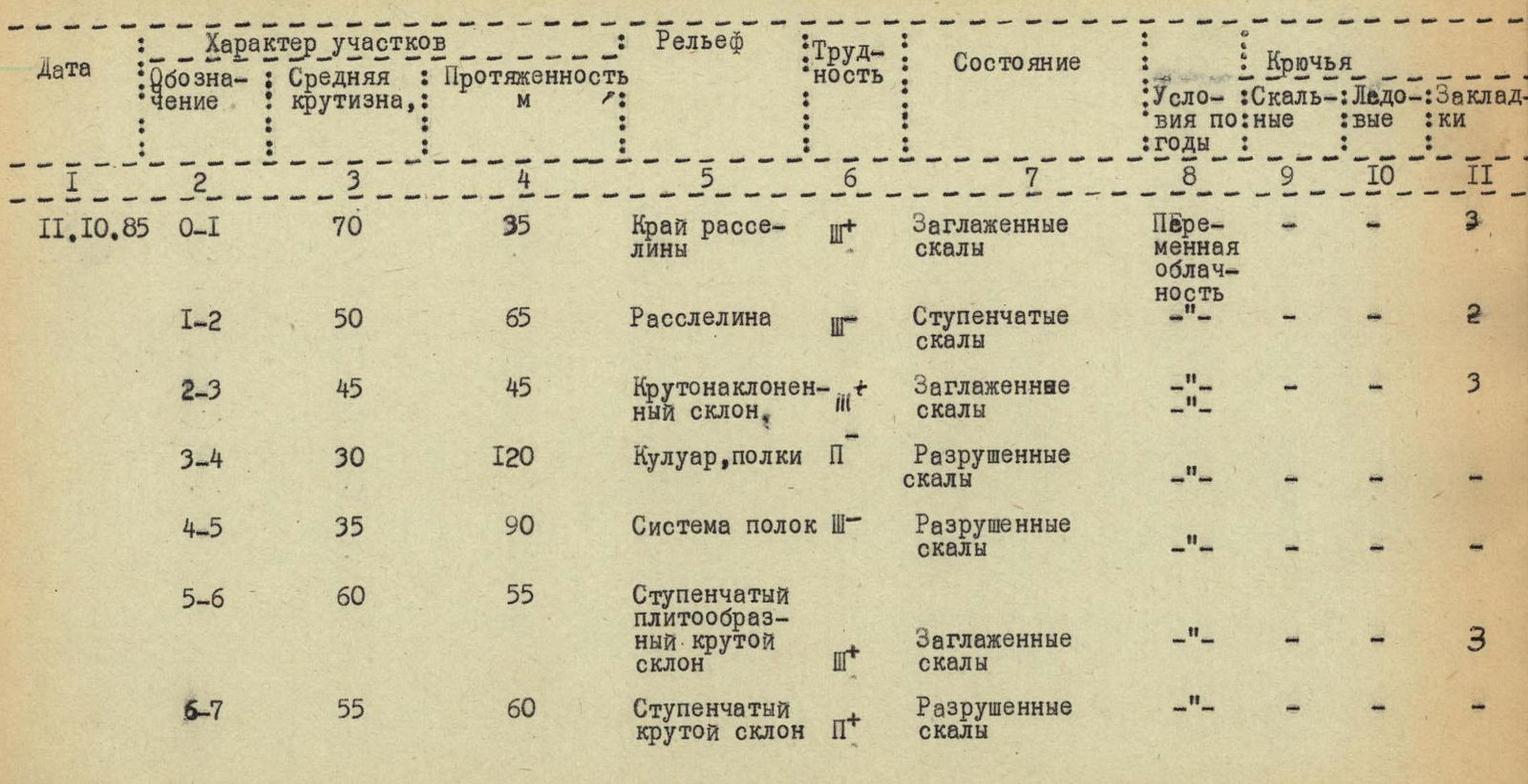
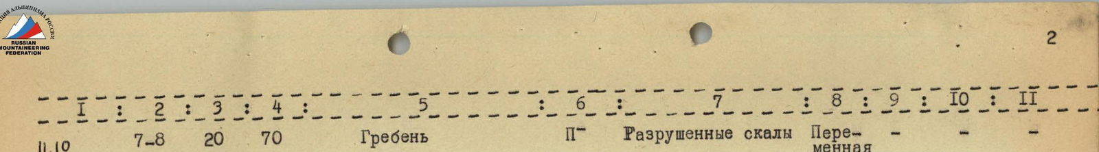


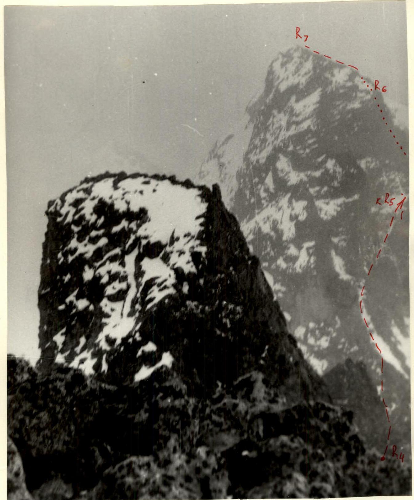
Photo 4. View of the South-Western counterfort from the peak «Dimitrov-100» on October 12, 1985.
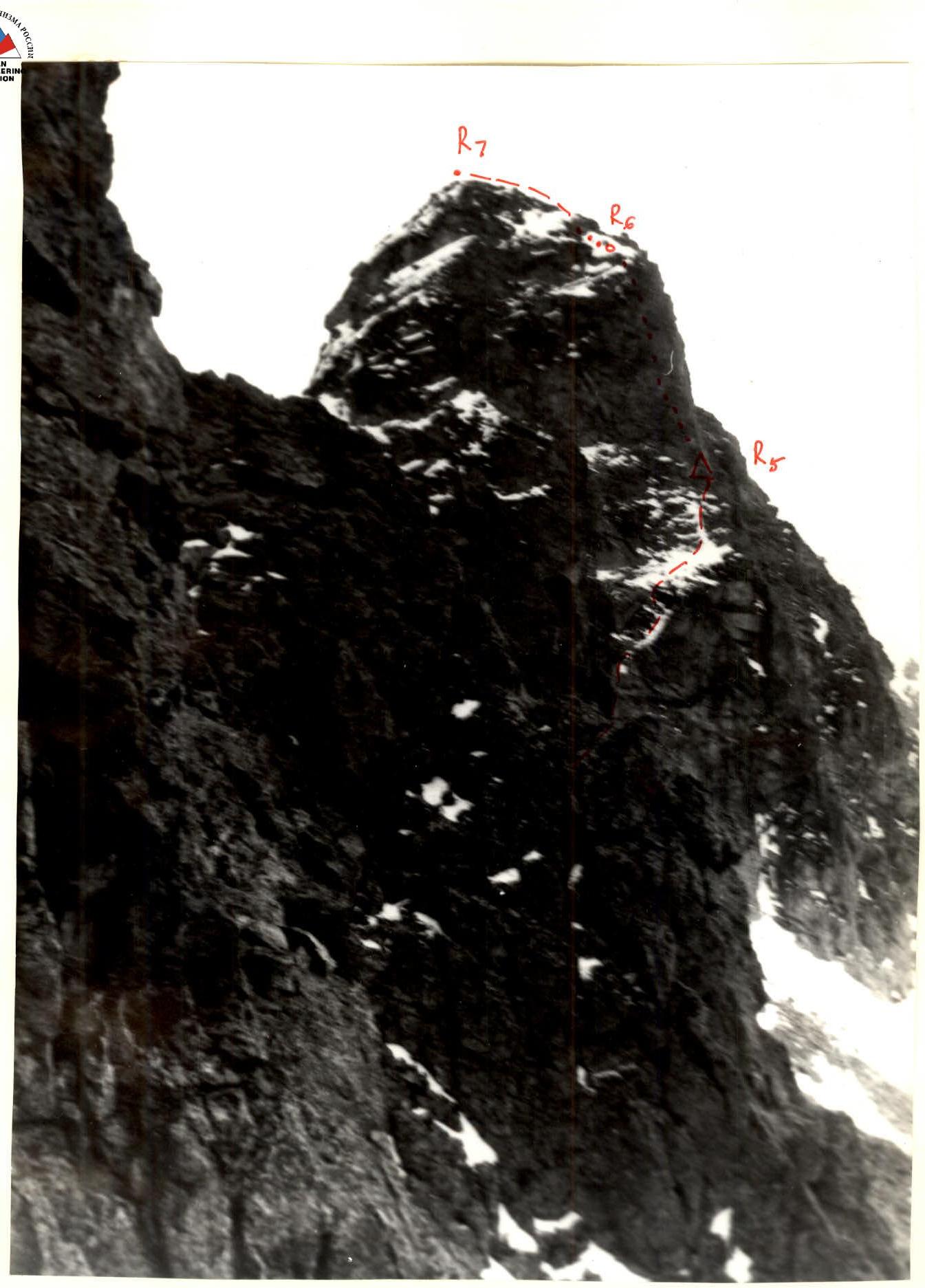
Photo 5. South-Western counterfort from the south side of the Central sentinel. October 12, 1985. The wide snow-covered rocky area is clearly visible.