I. CLIMBING CLASS
Rocky terrain
-
CLIMBING AREA, RIDGE Western Caucasus, North-Western spur of the Sofiyskiy ridge between the Pshish and Sofia river valleys
-
PEAK, ITS HEIGHT, ASCENT ROUTE, ROUTE CHARACTER Bolgaro-Sovetskoy druzhby, 3206 m, via the Western ridge, rocky terrain
-
PROPOSED DIFFICULTY CATEGORY 1B
-
ROUTE CHARACTERISTICS Height difference 350 m, average steepness — 35°
-
PITOONS DRIVEN IN none
-
NUMBER OF CLIMBING HOURS 3.5
-
NUMBER OF NIGHTS AND THEIR CHARACTERISTICS The route is completed within daylight hours
-
CLIMBERS' COMPOSITION Leader: — Zaporozhchenko E.V., CMS Participants: — Roschin Yu.M., 1st sports category
-
TEAM COACH — Damianidi I.G., MS
II. DATE OF ASCENT TO THE SUMMIT AND RETURN
— October 6, 1986
- ORGANIZATION — Stavropolkraisportcommittee
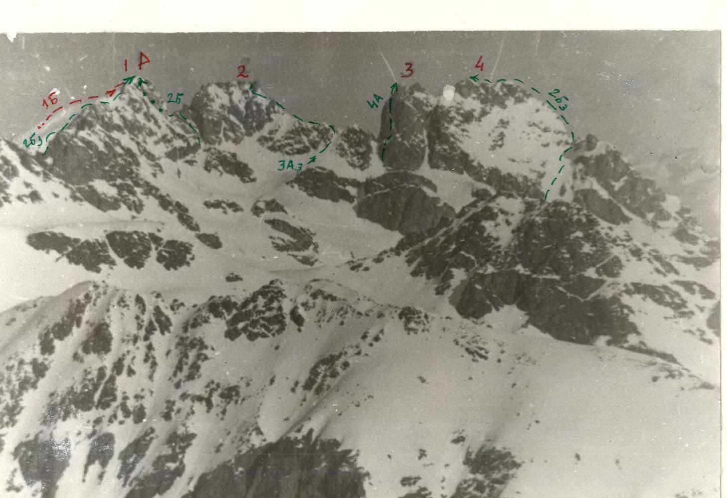
Photo 1. General view. Peaks: — 1 — Bolgaro-Sovetskoy druzhby (3206 m); — 2 — Dimitrov-100 (3226 m); — 3 — 40 let NRB (3201 m); — 4 — XIX syezd VLKSM (3171 m). — 4A — Classified routes (as of 1.11.1986) — ––– — First ascent route
There are two classified routes to the summit of Bolgaro-Sovetskoy druzhby (3206 m): 2B category via the NE slope and SE ridge, and 2B category via the N slope and SW counterfort. To the Southeast of the Bolgaro-Sovetskoy druzhby peak lies the Bolgarskoy kompartii peak (3160 m) with a classified 1B category route, and to the Northwest — the "Dimitrov-100" peak (3226 m) with a classified 3A category route (photo 1).
The path to the campsite by the lake under the significant slopes of the "60 let KChAO" peak, as well as from these campsites to the Karadjasch pass (~1.5 hours), has been described previously (see, for example, the report on the first ascent of Batak peak, 3130 m, as well as the "Orographic scheme").
From the Karadjasch pass to the Orlyonok pass (~2850 m), one must follow the bases of the southern counterforts of Batak, Bolgarskoy kompartii, and Bolgaro-Sovetskoy druzhby peaks, along a large scree for 2–2.5 hours. The pass drops down to the south (towards the "Crater" lake) in a wall. The exit is to the right, through: — a narrow "pipe" in the rocks, — a steep scree.
There is another option for ascending to the Orlyonok pass — via the Bazarnы-Chat gorge. However, with the usual alpinist base at the "Ice Farm", using this option is impractical.
Campsites can also be arranged by the "Crater" lake when other ascents via classified routes in the Karadjasch tract are not planned, and the main goal is to complete the described route.
From the highest point of the Bolgaro-Sovetskoy druzhby peak, the Western ridge descends directly to the Orlyonok pass (photos 2, 3, 4).
The 2B category route, via a short but steep SW counterfort, leads to the sub-summit. It remains to the left (photo 5) when moving along the Western ridge from the pass.
The Western ridge steeply drops down to the north and has a more gentle southern slope.
Route Description
Due to the absolute logic of the route — the movement goes strictly along the ridge, slightly to the right of the watershed line — there is no need to include a diagram in a unified symbol system in the route description.
Section R0–R1 (photo 6)
The ridge in this steepest section (d ≈ 45°) is a system of stepped walls, fins, and steep crests. The latter, without significant difficulties, with simultaneous movement and rope placement around outcrops, are generally bypassed to the right. Only when rock obstacles in the form of granite needles and other protruding forms shift slightly to the right of the abrupt northern edge of the ridge is it possible to pass at the base of these forms to the left (photo 7).
The length of this section is about 350 m. For a team of beginner climbers, it is advisable to install belays in 2–3 places. Category: P+.
Section R1–R2
The ridge, through a small gently sloping segment (photo 8), becomes less steep, initially to 35°, and then, closer to the summit, to 30°, and noticeably widens. To the left of the direction of travel, 100–120 m from the summit, it drops down not in walls but in steep snowy slopes (photo 9). There are no significant gendarmes on the ridge.
The movement now proceeds on the remaining 200-meter segment, to the right of the watershed line. Category: initially P, the last 100 m — 1.
The descent can be made either by the ascent route (for beginner climbers) or via a slightly more complex but significantly shorter route through the Karadjasch pass — via the 2B category route (along the SE ridge) to the Eastern sub-summit, then down to the right along rocky crests and steep screes until intersecting with half the distance between the Karadjasch and Orlyonok passes. This is how the descent is made when completing the 2B category route via the N slope and SW counterfort. The estimated time for completing the route from the Orlyonok pass to the summit: 3.5–4 hours (a team of beginner climbers will need about 5 hours).
The route corresponds to 1B category and has a rocky character.
The first ascent was made as part of the Year-Round Event 1986 of the Kavminvodskaya section of the Stavropol regional alpine federation.
Compiled by E.V. Zaporozhchenko, Pyatigorsk October 1986