
108427.2
FIRST ASCENT ROUTE DIAGRAM (according to UNAF) to the summit of Kelbashi via the North ridge ~16 km
I+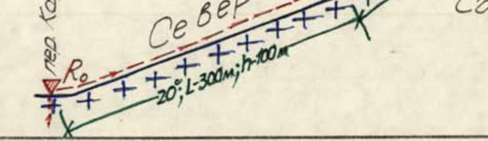 The summit of Kelbashi (3243 m, photo I) is situated in the Sofiyskiy ridge between the Stolichny and Karadjasch passes. It is present on all topographic maps. The name is local. The first ascent was made by a group led by S.A. Chuеnko in January 1982 as part of the traverse "60 let KChAO–Peshtera–Septemvri–Kelbashi". This route is categorized as 3A.
From the Karadjasch pass to the summit of Batak via the south ridge, there is a categorized route 2A.
The present first ascent was made within the framework of the Stavropol krai sports committee alpinada "Arkhyz-88" by members of the rescue team of this event.
The north-eastern slopes and part of the north ridge up to the junction with the spur running down to the summit of Septemvri (see the orographic diagram) are covered with ice. Only the summit area is free of it.
From the "Syrzavod" base camp, the path initially follows the Kashka-Ecshek stream, then in the direction of the saddle between the summits of 60 let KChAO and Peshtera. Approximate time — 3 hours.
From the saddle:
- traverse along the slopes of the summits Peshtera and Septemvri
- to the ascent to the Karadjasch pass — 1 hour
- ascent to the pass — 30–45 minutes.
Route Description
SECTION R0–R1: from the Karadjasch pass (~2800 m absolute height) left with a 15–20° slope up the wide rock-snow saddle to the base of the north ridge (photo 2).
- L ~ 300 m
- h ~ 100 m
- 1
SECTION R1–R2: via snow with a slope of 20–25° at the beginning, at the end, at the exit to the east ridge — 35°.
- L ~ 200 m
- h ~ 100 m
- 2
SECTION R2–R3: via snow (ice in summer) of the east ridge, in teams, straight up (photo 3) to its turn to the south. Average slope 35°. At the exit — 40–45°.
- L ~ 200 m
- h ~ 150 m
- 2
SECTION R3–R4: Along a narrow, with cornices, rock-snow ridge, gently (~15°) rising to the rocky summit tower to its base.
- L ~ 80 m
- h ~ 30 m
- 2
SECTION R4–R5: After a 5-meter descent to the saddle, bypassing the base of the summit along steep rocks covered with snow, with a 20–25-meter ascent, then via an inner corner up ~30 m with 70° to a narrow ridge and along it 15–20 m to the summit. The key point of the route! Ropes or alternating belay (2–3 pitons or nuts).
- 3
Descent — via the ascent route. Time taken to complete the route (from the pass to the summit) — 3–4 hours. Descent — 1.5–2 hours. The entire route, from spring to late autumn, can be completed (from the base camp — 1800 m absolute height) within a daylight period.
Compiled by  E. Zaporozhchenko
Pyatigorsk, December 1988