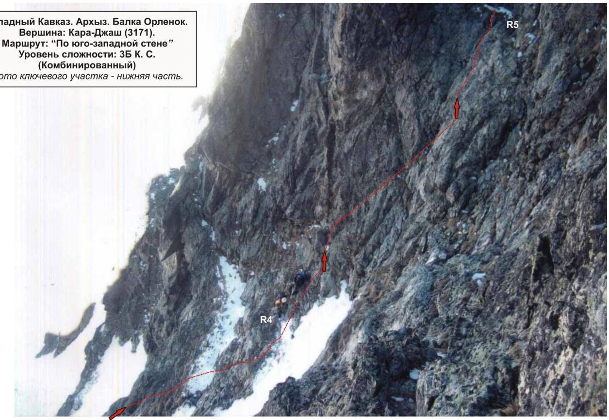
Western Caucasus. Arkhyz. Orlenok hollow. Summit — Kara-Jash (3171 m). Route: "Via the southwestern wall" 3B (combined)
Summit Description
Kara-Jash summit (3171 m) — a nodal summit of the mountain massif (on old maps — ridge) Kara-Jash. Located on the territory of the Caucasian Federal District of the Russian Federation, in Karachay-Cherkess Republic, Arkhyz mountain region (Orlenok hollow), between the rivers Pshish, Sofia, and Orlenok.
Kara-Dash summit (3171 m) — a pronounced mountain of the Karajash ridge, easily identifiable from the Taulu clearing, located at the confluence of the Sofia river into Pshish river. The official name of the summit, marked on the geographical maps of the Russian Federation (Scale: 1 cm — 1 km), translates from the Karachay-Balkar language as "Black Prince".
Route Description
The route "Via the southwestern wall" is a technically interesting sports route. The route is logical. The key part of the route is a rock section of increased complexity.
Equipment
To complete the ascent as part of a sports team of 2 people, the following special equipment is required on the route:
Personal — standard:
- Crampons
- Ice axe for approaches
Group:
- Main rope 10 mm — 2×60 m
- Rock hammer — 2 pcs.
- Rock pitons — 16 pcs.
- Ice axe — 1 pc.
- Nut protection — 12 pcs.
- Cams — 6 pcs.
- Ice screws — 0 pcs.
- Quickdraws — 16 pcs.
- Slings — 10 pcs.
Rock shoes are necessary for the leader!
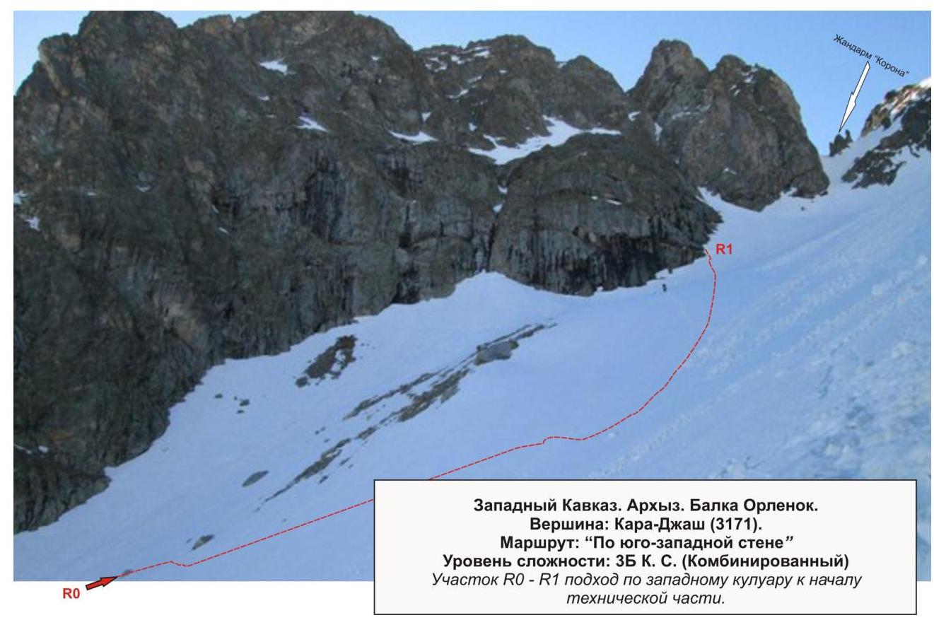
Approach
The ascent is made from a bivouac in the upper cirque of Orlenok hollow. The approach to the bivouac in the upper cirque is not complicated: from the Taulu clearing, cross the Sofia river via a bridge and ascend through Orlenok hollow — initially along a logging road, then along a clearly visible trail.
The cirque is pronounced: in winter and spring — snowy, in summer — overgrown with high-altitude vegetation and featuring two beautiful lakes among small birch and pine groves.
The ascent from the Taulu clearing to the cirque takes 1.5–2 hours. The cirque has convenient spots for tents, with water (streams) and dry areas that become snow-free by the end of April — beginning of May.
The height of the bivouac by the lake above sea level is 2200 m.
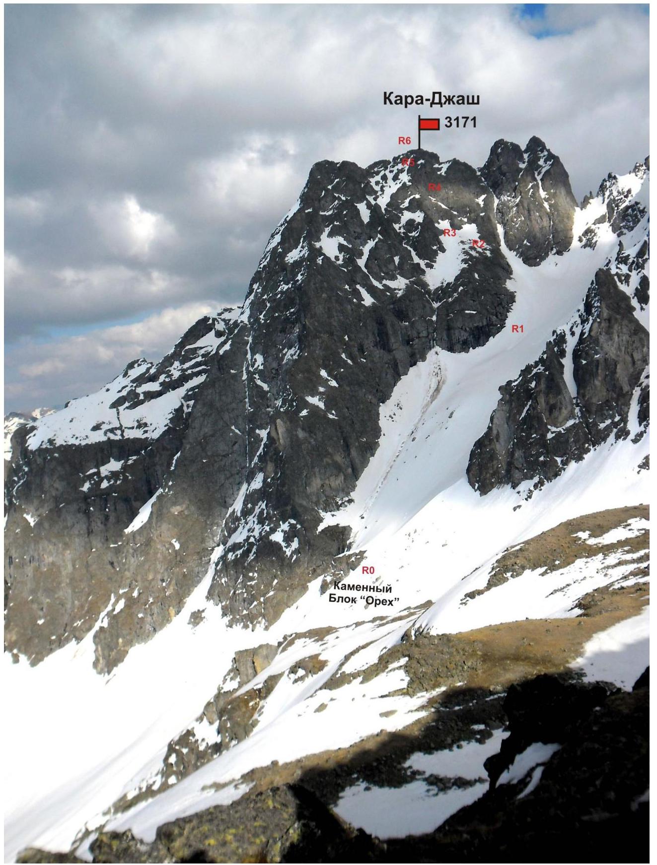
In the panorama of the cirque, Kara-Jash summit is the dominant and easily identifiable peak.
The approach from the campsite to the start of the route — the "Orekh" rock block — takes about an hour.
Technical Part
The route begins with an ascent through a snowy couloir, sticking to the center. After passing the exit of the scree couloir (on the left), approach the rock base of the wall. Then ascend несложным скалам to a terrace.
Terrace:
- wide
- can serve as a temporary bivouac site
Along the terrace, traverse the wall to the left, towards a pronounced rock buttress. Wall — exit to the buttress ridge — the key part of the route!
The key part of the route is a very complex steep rock wall with minimal ledges and relief for intermediate anchors.
After passing the key part, the route continues to require quality climbing from the leader and creation of intermediate anchors every 35 m. A more gentle rock wall follows, leading to the buttress ridge. Climbing is done through the center.
Passing these 120–150 m requires:
- a group leader with rock climbing skills;
- quality interaction between the rope team.
After the wall section, a несложный гребень контрфорса выводит на вершину.
The summit is a rock pyramidal peak, well-defined.
Descent from the Summit
Descent from the summit is made via the 2B category route — initially along the northern ridge to the saddle between Kara-Jash, Kara-Jash (Northern), and Kara-Jash (Northeastern) peaks. Then down the eastern couloir into the Gammesh-Chat river valley. Then:
- follow the trail along the river down to the Sofia river valley,
- cross the river via a log bridge,
- descend along a dirt road to the Taulu clearing.
You can return to Orlenok hollow via:
- Gammmesh-Chat — Gnilaya (Lipetsky) pass,
- traverse through the upper cirque of Gnilaya hollow,
- via Gnor pass.
Passport
- Section number according to KMGV — 2010 — 2.1.
Western Caucasus, Arkhyz mountain region, Orlenok hollow, Kara-Jash mountain massif (ridge)
- Summit name: Kara-Jash
- Height: 3171 m
- Route: via the southwestern wall
- Category of complexity: 3B
- Route type — combined
- Height difference of the route: 670 m
- Route length: 810 m
- Length of sections with the highest category of complexity: 1st category section — 1 section — 450 m, 2nd category — 2 sections — 180 m, 3rd category — 0 sections — 0 m, 4th category — 1 section — 60 m, 5th category — 1 section — 60 m, 6th category — 0 sections — 0 m
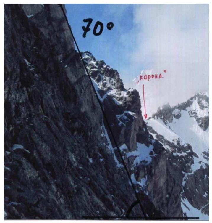
- Average steepness: key part of the route — 70 degrees.
overall route — 60 degrees.
- Pitons used:
Total pitons used on the route:
- rock pitons — 10
- nuts — 34
- bolted anchors — 0
- ITO — A4 — 5 points
- removable bolts — 0
Pitons left on the route: total — 4; including bolted — 0, nuts — 0.
- Route start — 5:00, August 8, 2013.
Reached the summit — 16:00, May 8, 2013. Returned to BL — 21:00, May 8, 2013.
- Team's total hours: — 16 hours.
- Team leader: Vladimir Kuznetsov (2nd sports category, Nevinnomyssk).
Team members:
- A. Kuznetsov (2nd sports category, Nevinnomyssk)
- V. Kuznetsov (2nd sports category, Nevinnomyssk)
- A. Pisetsky (2nd sports category, Cherkessk)
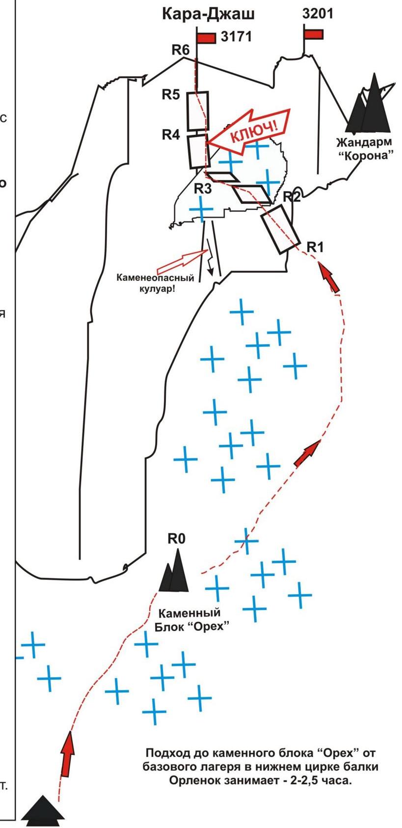
- Coach: Yu. Fursov, title — CMS, instructor-methodologist 2nd category. R0 — start of the route at the "Orekh" rock block. R0–R1. Ascent through a snowy couloir under the southwestern wall. Snow couloir. Length 450 m. Steepness — 30–45°. Complexity level — 1B category. Movement is simultaneous. Self-belay with an ice axe. R1–R2. Ascent along an inclined wall to a terrace. Length — 150 m. Steepness — 45°. Complexity level — 2+, 3− category. Movement with alternating belay. Rock pitons/nuts used — 2/10 pcs. Left on the route — 0/0 pcs. R2–R3. Traverse along the wall on the terrace to a rock buttress. Length — 60 m. Steepness — 10°. Complexity level — n/k. Movement is simultaneous. Convenient spot for a night's stay. R3–R4. Passage of the route's key part. Rock smoothed wall-monolith. Length — 60 m. Steepness — 70°. Complexity level — 5− category. Movement with alternating belay. Rappel. Leader in rock shoes. Rock pitons/nuts used — 6/12 pcs. Left on the route — 2/0 pcs. R4–R5. Exit to the rock ridge of the buttress. Rock wall. Length — 60 m. Steepness — 65°. Complexity level — 4− category. Movement with alternating belay. Rappel. Leader in rock shoes. Rock pitons/nuts used — 2/12 pcs. Left on the route — 0/0 pcs. R5–R6. Ascent to the summit. Rock ridge. Length — 30 m. Steepness — 45°. Complexity level — 2+ category. Movement is simultaneous, on a shortened rope. R6 — Kara-Daj summit (3171 m). DESCENT: Along the northern ridge and eastern couloir via the 2B category route. Into the Gammesh-Chat hollow.
Western Caucasus. Arkhyz. Orlenok hollow. Summit — Kara-Jash (3171 m). Route: "Via the southwestern wall" 3B (combined) Scheme in UIAA symbols
Western Caucasus, Arkhyz, Orlenok hollow. Kara-Jash mountain massif. Summit Kara-Jash (3171 m). Route: "Via the southwestern wall". 3B (combined) (approximate).
(table of natural obstacles on the route — appendix to the scheme in UIAA symbols)
| section | Length | Steepness | Relief character | Category | Pitons/nuts used |
|---|---|---|---|---|---|
| R0 — start of the route at the "Orekh" rock block | Convenient spot for organizing the rope team. | ||||
| R0–R1 Passage through the couloir to the base of the southwestern wall (right of the rockfall couloir) | 450 | 30-45 | Snow, firm snow in summer | 1,2- | 0/0 |
| R1–R2 Passage of the inclined wall | 150 | 45 | Rock slabs, inclined walls with diverse relief | 2+, 3− | 2/0 10/0 Convenient spots for belay |
| R2–R3 Traverse along the southwestern wall on the terrace to the buttress. | 60 | 10 | Wide shelf-terrace. Probable spot for a night's stay | н/к | 0/0 0/0 |
| R3–R4 Passage of the monolithic rock wall. KEY ROUTE PART! | 60 | 70 | Dense steep smoothed rocks (rock shoes!) | 5- | 6/0 12/0 Convenient spot for belay |
| R4–R5 Passage of the second wall and exit to the pre-summit ridge of the counterfortress | 60 | 65 | Rock wall (rock shoes!) | 4+ | 2/0 12/0 Convenient spot for belay |
| R5–R6 Ascent to the summit along the ridge | 30 | 45 | Rock ridge | 2+ | 0/0 0/0 |
| counterfortress | |||||
| R6 — Kara-Jash summit (3171 m) | |||||
| DESCENT | Along the southern ridge and eastern couloir — 2B category. |
Total:
Route length — 810 m. Average steepness — 60°. Relief character — combined.
- Sections of 1st category — 1 section — 450 m
- 2nd category — 2 sections — 180 m
- 3rd category — 0 sections — 0 m
- 4th category — 1 section — 60 m
- 5th category — 1 section — 60 m
- 6th category — 0 sections — 0 m
Pitons used/left — 10/4, nuts —
0/0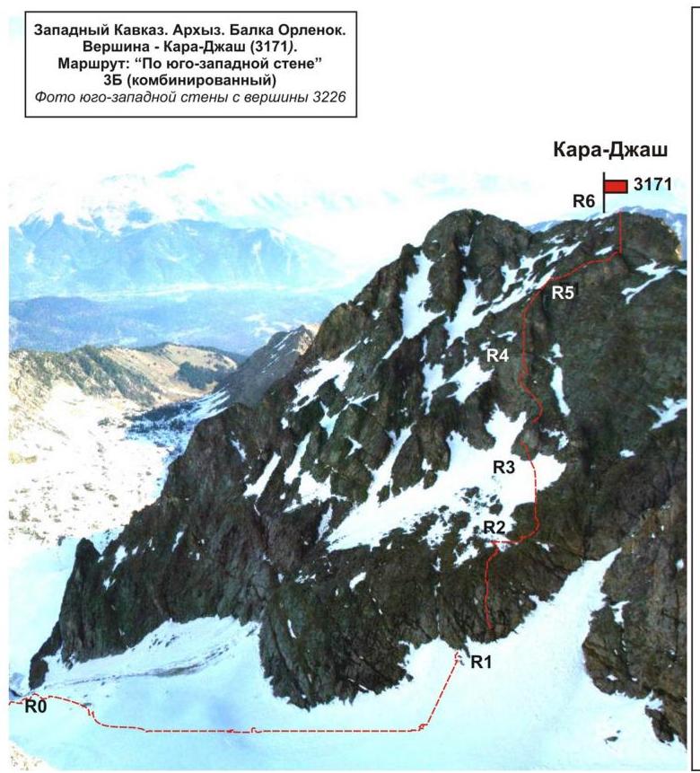
R0 — start of the route — "Orekh" rock block.
- R0–R1Ascent through a snowy couloir under the southwestern wall. Length 450 m. Steepness — 30–45 degrees. Complexity level — 1st category. Movement is simultaneous. Self-belay with an ice axe.
- R1–R2Ascent along an inclined wall to a terrace. Length — 150 m. Steepness — 45°. Complexity level — 2+, 3− category. Movement with alternating belay. Rock pitons/nuts used — 2/10 pcs. Left on the route — 0/0 pcs.
- R2–R3: Traverse along the wall on the terrace to a rock buttress. Length — 60 m. Steepness — 10°. Complexity level — n/k. Movement is simultaneous. Convenient spot for a night's stay.
- R3–R4: Passage of the route's key part. Rock smoothed wall-monolith. Length — 60 m. Steepness — 70°. Complexity level — 5th category. Movement with alternating belay. Rappel. Leader in rock shoes. Rock pitons/nuts used — 6/12 pcs. Left on the route — 2/0 pcs.
- R4–R5: Exit to the rock ridge of the buttress. Rock wall. Length — 60 m. Steepness — 65°. Category — 4B. Movement with alternating belay. Rappel. Leader in rock shoes. Rock pitons/nuts used — 2/12 pcs. Left on the route — 0/0 pcs.
- R5–R6: Ascent to the summit. Rock ridge. Length — 30 m. Steepness — 45 degrees. Category — 2B. Movement is simultaneous, on a shortened rope.
R6 — Kara-Jash summit (3171).
DESCENT: Along the northern ridge and eastern couloir via the 2B category route. Into the Gammesh-Chat hollow.
Western Caucasus. Arkhyz. Orlenok hollow. Summit: Kara-Jash (3171). Route: "Via the southwestern wall" Complexity level: 3B category (Combined)
Section R0–R1:
- Approach through the western couloir to the start of the technical part.
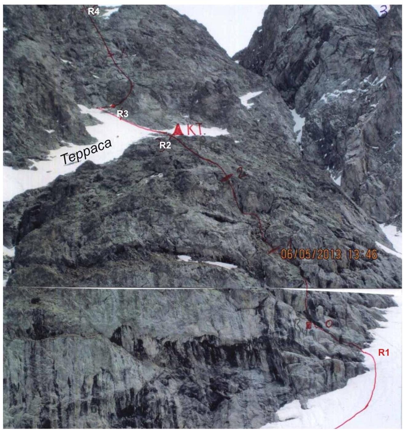
Western Caucasus. Arkhyz. Orlenok hollow.
Summit: Kara-Jash (3171)
Route: "Via the southwestern wall"
Complexity level: 3B category (Combined)
Photo:
- first technical section (exit to the terrace)
- approach under the key part of the route
- key section — lower part
May 2013.
Western Caucasus. Arkhyz. Orlenok hollow.
Summit: Kara-Jash (3171)
Route: "Via the southwestern wall"
Complexity level: 3B category (Combined)
Photo-profile of the key section.
May 2013.
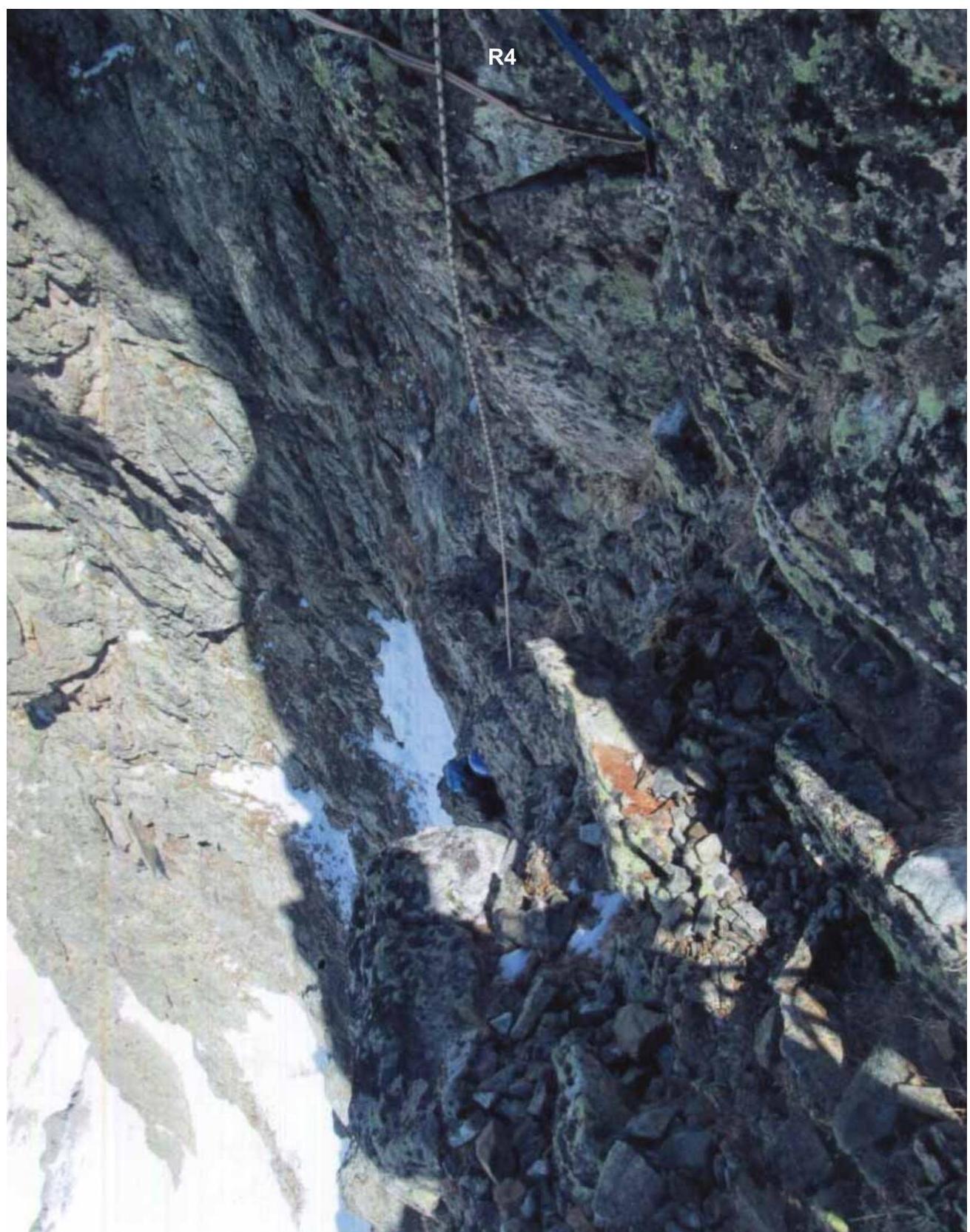
Western Caucasus. Arkhyz. Orlenok hollow.
Summit: Kara-Jash (3171)
Route: "Via the southwestern wall"
Complexity level: 3B category (Combined)
Photo of the key section.
Station between R4 and R5 with ropes (R4)
May 2013.