Peak 2900 (Kara-Dzhash North-Eastern). Route: via the Eastern couloir and the Southern ridge. Cat. difficulty: 1B* (combined). Leader: A. Yarunov
Western Caucasus, Arkhyz, Orlenok gully, Kara-Dzhash mountain range. Section in CMGA - 2.1.
E-mail — ZHUR58@RAMBLER.RU
Report
On the first ascent of the climbing route to peak 2900 (Kara-Dzhash North-Eastern) "Via the Eastern couloir and the Southern ridge 1B* (combined)".
At the year-round alpine event:
- Climbing competition
- NP "Club of Northern Travels 'Sauk-Pay'"
- 2013 — "Victory Cup"
- Class "First ascents"
Region: Karachay-Cherkess Republic Mountain country: Western Caucasus Gully: Orlenok gully Ridge (mountain range): Kara-Dzhash Peak: 2900 (Kara-Dzhash North-Eastern) Route: "Via the Eastern couloir and the Southern ridge" Level of difficulty: 1B* (combined). Prepared by: A. Yarunov, S. Zhuravlev May, 2013 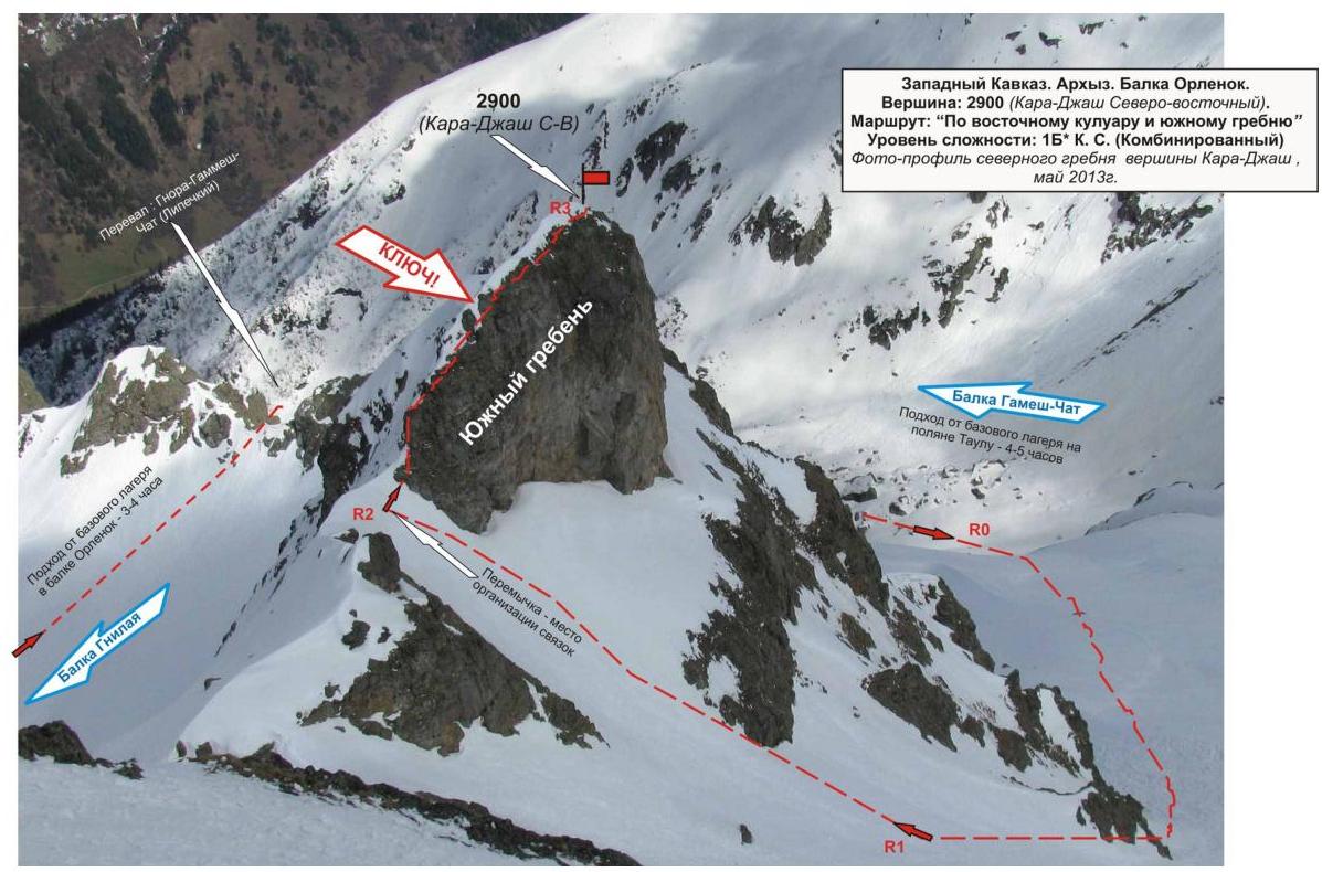
Passport
- Number of section according to CMGA — 2010 — 2.1.
Western Caucasus, mountain region — Arkhyz, Kara-Dzhash ridge
- Name of peak: 2900 (Kara-Dzhash North-Eastern)
height: 3070 m
Route: via the Eastern couloir and the Southern ridge
- Cat. difficulty: 1B
- Character of the route — combined.
- Height difference of the route: 600 m
- Length of the route: 640 m
- Length of sections of the highest category of difficulty:
1 cat. difficulty — 1 section — 500 m
2 cat. difficulty — 2 sections — 140 m
3 cat. difficulty — 0 sections — 0 m
4 cat. difficulty — 0 sections — 0 m
5 cat. difficulty — 0 sections — 0 m
6 cat. difficulty — 0 sections — 0 m.
- Average steepness: main part of the route — 50 degrees.
entire route — 45 degrees.
- Used pitons:
Used total on the route:
- rock pitons — 2,
- chocks — 6,
- stationary bolt pitons — 0,
- ITO — 0,
- removable bolt pitons — 0. Left "pitons" on the route: total — 0; including bolt pitons — 0.
-
Exit to the route — 5 hours, May 9, 2013
| Exit to the summit — | 08-00, 9.05.2013 | | ------------------ | ---------------- | | Return to Base Camp — | 12-00, 9.05.2013 |
-
Team's climbing hours: — 7 hours.
-
Leader: A. Yarunov (Candidate for Master of Sports, instructor-methodologist 3rd category (Sevastopol).
Participants: V. Plotnikov (3rd sports category, Voronezh), E. Sochko (3rd sports category, Syktyvkar), O. Moiseeva (3rd sports category, Syktyvkar).
- Coach: Zhuravlev Sergey Vasilyevich, title — Candidate for Master of Sports, instructor-methodologist 1st category.
Note: Due to unstable weather on the day of the first ascent, photographs of the second ascent led by A. Lyapunov (Sevastopol, Master of Sports, instructor-methodologist 2nd category) are provided for the report.
Description of the peak
Peak 2900 m (Kara-Dzhash North-Eastern) — one of the peaks of the Kara-Dzhash massif, located at the junction of the north-eastern spur to the Kara-Dzhash mountain massif. Located on the territory of:
- Caucasus Federal District of the Russian Federation,
- Karachay-Cherkess Republic,
- Arkhyz mountain region,
- between the tributaries of the Sofia River — Gnilaya River and Gammesh-Chat River.
Peak 2900 (Kara-Dzhash North-Eastern) — a pronounced peak of the Kara-Dzhash ridge, easily identifiable from the Taulu meadow, located at the confluence of the Sofia River and the Psyish River. The name of the peak Kara-Dzhash North-Eastern is unofficial, not marked on the geographical maps of the Russian Federation (Scale: 1 cm — 1 km), used for identification purposes.
Description of the route
The route "Via the Eastern couloir and the Southern ridge" — a seasonal training combined route of 1B category of difficulty, with a full set of natural obstacles corresponding to routes of this level. The passage of this route has not only aesthetic but also practical training and sports significance, as it allows within the framework of the ascent to practice:
- belaying techniques;
- self-belaying techniques on rocky terrain.
Equipment
For the ascent as part of a training and sports group of 6 people (5 participants + instructor), the following special equipment is required on the route:
Personal:
- Standard issue
- In the off-season: crampons and ice axe
Group:
-
Main rope 10 mm — 3×50 m
-
Rock hammer
-
2 pcs., rock pitons — 4 pcs., ice axe — 1 pc., chock elements — 6 pcs. Ice screws — 0 pcs. Quickdraws — 6 pcs. Loops — 4 pcs.
Approach
If the ascent is made from the Taulu meadow, it is necessary to ascend along the road to the crossing over the Sofia River above the confluence of its tributary Gammesh-Chat.
Then, along the valley of the river, ascend to the upper cirque of the Gammesh-Chat gully and approach the base of the Eastern couloir, leading to the saddle between peaks Kara-Dzhash (3171) and 2900 (Kara-Dzhash North-Eastern).
If the ascent is made from the bivouac in the upper cirque of the Orlenok gully, it is necessary to first ascend from the Taulu meadow to the upper cirque of the Orlenok gully.
The approach to the bivouac in the upper cirque is not complicated in terms of orientation:
- From the Taulu meadow, cross the Sofia River via the bridge.
- Ascend along the Orlenok gully — first along the logging road, then along a well-defined trail.
The cirque is clearly expressed:
- In winter and spring off-season — snowy.
- In summer — overgrown with high-altitude vegetation, with two beautiful lakes among small birch and pine groves.
The height of the cirque above sea level is 2200 m. The ascent from the Taulu meadow to the cirque takes 1.5–2 hours.
In the cirque, there are convenient places for tents, with water (lake, streams) and dry areas, freed from snow in late April — early May.
From the bivouac in the upper cirque of the Orlenok gully, peak 2900 (Kara-Dzhash North-Eastern) is not visible — it is obscured by the rocky massif of the northern ridge.
Route from the bivouac:
- Ascend along the snowy slope to the Gnora pass (1A in tourist classification).
- Cross into the Gnilaya gully.
- Along the snow-covered large-block talus along the eastern wall of the northern ridge, approach the north-eastern spur coming from peak 2900 m (Kara-Dzhash North-Eastern).
- Cross the north-eastern spur via the Gammesh-Gnilaya pass (2A in tourist classification).
- Traverse along the slope along the eastern wall towards 2900 m (Kara-Dzhash North-Eastern), approach the base of the Eastern couloir.
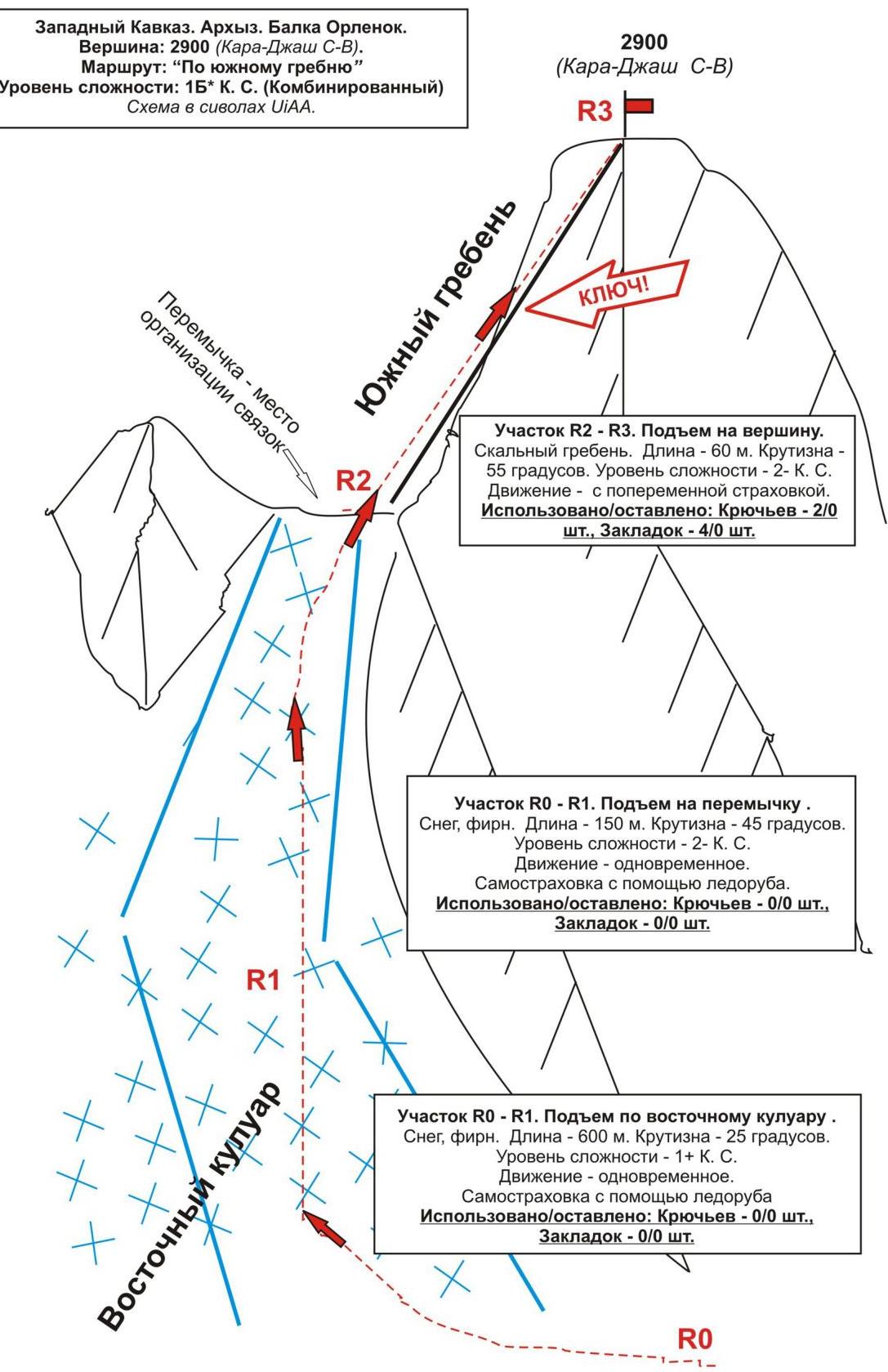
Technical part
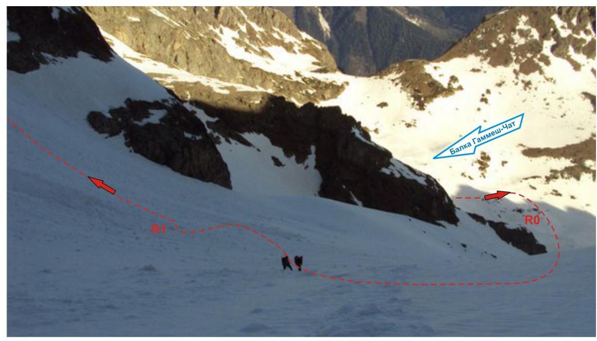
The route begins with an ascent along a wide — snowy couloir. (In winter and off-season, the couloir may be avalanche-prone!) Ascend along the couloir to the saddle and the beginning of the Southern ridge of peak 2900 (Kara-Dzhash North-Eastern). On the saddle, it is convenient to organize rope teams.
Key to the route:
- Rocky ridge leading to the summit tower.
- Climbing is not complicated but requires organization of intermediate belay points.
- Objective rockfall danger.
- In the off-season, possible ice formation on rocks.
Ascend along the ridge to the summit. The summit is peak-shaped, clearly expressed. The cairn is easily found.
Descent from the summit
Descent from the summit via the ascent route. Then, it is possible to descend along the Gammesh-Chat valley to the Sofia River and return to the Taulu meadow.
To return to the upper cirque of the Orlenok gully, it is necessary to ascend along the Eastern spur coming from peak 3070 (Kara-Dzhash North-Eastern) to the Gammesh-Gnilaya pass (2A in tourist classification).
On the descent from the Gammesh-Gnilaya pass, it is necessary to organize three rappels:
- first along snow-covered, rugged rocks,
- then along snow-covered "ram's foreheads".
Then, cross the upper cirque of the Gnilaya gully, ascend to the Gnora pass (1A in tourist classification), and from the Gnora pass descend to the bivouac by the lake in the upper cirque of the Orlenok gully.
Western Caucasus, Arkhyz, Orlenok gully, Peak 2900 (Kara-Dzhash North-Eastern)
Route: "Via the Eastern couloir and the Southern ridge" 1B* (combined)
(approximate)
Table of natural obstacles on the route:
| Section | Length | Steepness | Character of terrain | Cat. difficulty | Number of pitons and chocks |
|---|---|---|---|---|---|
| R0–R1 Ascent along the snowy couloir | 500 | 30 | snow | 1-, 1+ | Rock — 0/0 Chock 0/0 |
| R1–R2 Ascent to the saddle under the base of the Southern ridge | 80 | 55 | snow | 2 - | Rock — 0/0 Chock 0/0 |
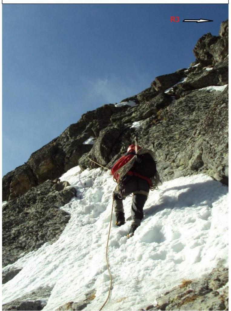
| R2–R3 Ascent to the summit along the rocky ridge | 60 | 55-60 | Rocky ridge | 2 | Rock — 2/0 Chock 6/0 |
Total:
Length of the route — 640 m. Average steepness — 40°. Character of terrain — rocky. Sections of 1st cat. difficulty — 1, 2nd cat. difficulty — 2. Used/left pitons — 2 / 0, chocks — 6 / 0. Analogous routes in other mountain regions:
- Chotchat — 1B via the Eastern ridge (Caucasus, Adyr-Su gorge)
- Turkhokh — 1B via the Eastern ridge (Caucasus, Tsey gorge)
Western Caucasus. Arkhyz. Orlenok gully. Peak: 2900 m (Kara-Dzhash North-Eastern). Route: "Via the Eastern couloir and the Southern ridge". Level of difficulty: 1B category (Combined). Section R1–R2. Ascent along the Eastern couloir to the saddle of the Southern ridge under the rocky tower. Photo with the saddle of the Southern ridge. May 2013 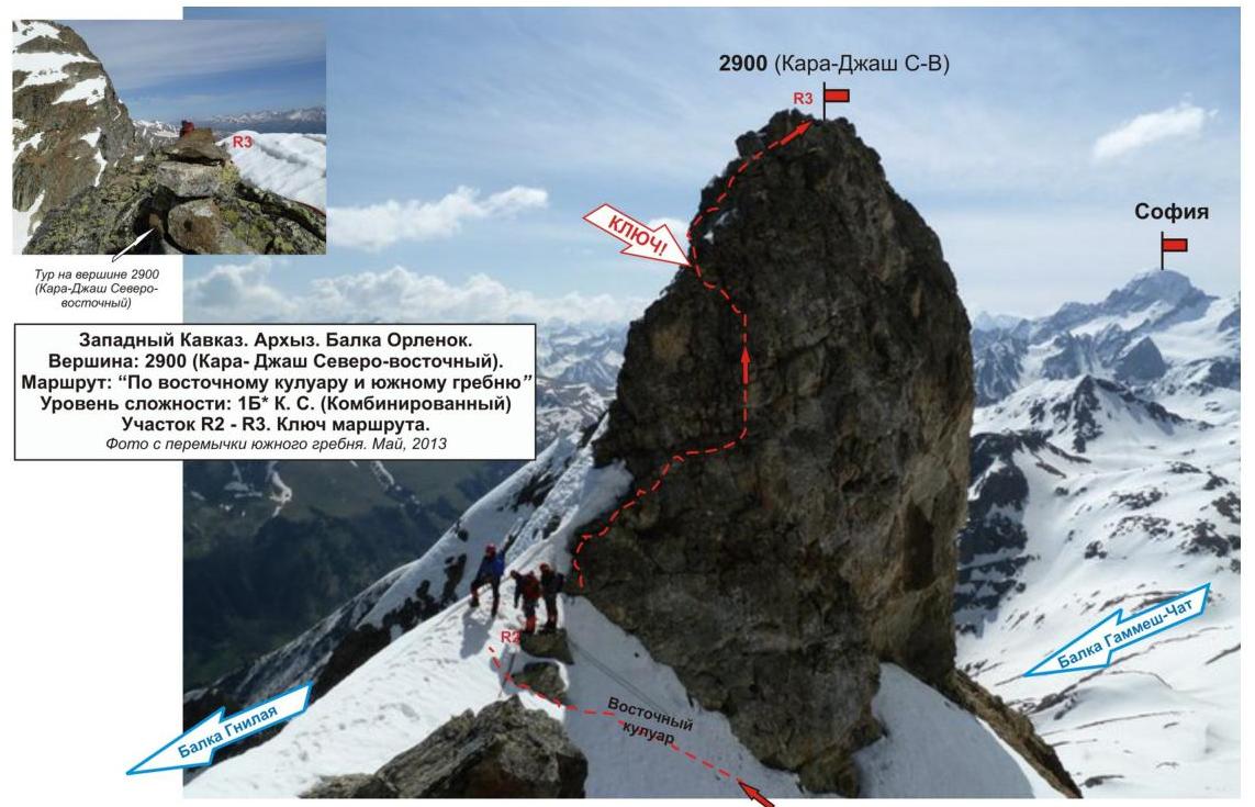 Western Caucasus. Arkhyz. Orlenok gully. Peak: 2900 m (Kara-Dzhash North-Eastern). Route: "Via the Eastern couloir and the Southern ridge". Level of difficulty: 1B category (Combined). Section R2–R3. Lower part of the rocky tower