Ascent Passport
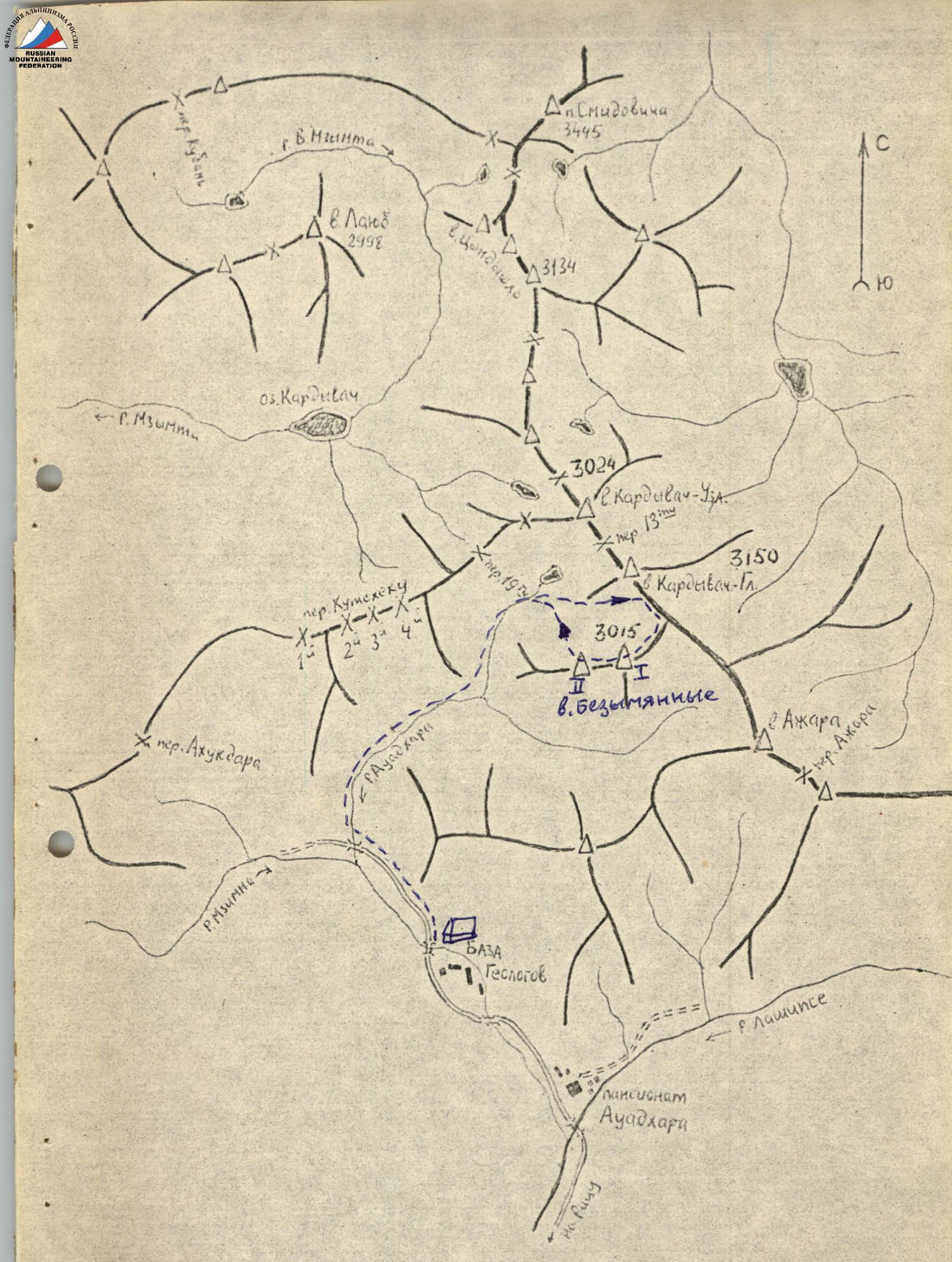
I. Ascent class: traverse 2. Ascent area, ridge: 2.I. Krasnodar Krai up to Marukh pass. 3. Peak, its height, ascent route: peaks — Bezymyannaya X — 3015 m and Bezymyannaya II — 3010 m; ridge route, combined (rocks, snow). along the NW ridge. 4. Proposed difficulty category: 3A 5. Route characteristics: height difference 700 m; average steepness 25°. 6. Pitons hammered:
| for belay | for creating artificial foothold | |
|---|---|---|
| rock | 3 | 0 |
| ice | 0 | 0 |
| bolt | 0 | 0 |
- Number of travel hours: 8 h
- Number of overnight stays and their characteristics: 0
- Surname, name, patronymic of the group leader, participants, and their sports qualification:
- Demichev Oleg Vladimirovich 2nd sports category leader
- Karshok Ivan Alekseevich participant
- Kasimov Alim Medzhitovich 1st sports category
- Melnik Vladimir Grigorievich 2nd sports category
- Melina Kira Nikolaevna participant
- Yastrzhembsky Aleksey Lazarevich 1st sports category
- Team coach: KOBYAKOV Vasily Petrovich. II. Date of departure and return — May 3, 1977.
Route Section
Brief Description of Approaches
To the route
From the base camp in the former houses of the geological party, the path goes to the end of the dirt road, to the clearing at the confluence of the Awadhara and Mzimna rivers. From the clearing along the right (orographic) bank of the Awadhara River, there is a trail. Further along the right (orographic) source of the Awadhara River with a gradual gain in height — exit to the snow circus formed by a section of the Main Caucasian Range with the peaks Kardyvach-Uzlовая and Kardyvach-Glavnaya and two spurs. From the circus to the right along the southern slopes of Kardyvach-Glavnaya peak, ascent to a small moraine surrounding Lake Udivlennoe, then along the moraine and then along the snowy slope to the saddle between the peaks Kardyvach-Glavnaya and Bezymyannaya I. When exiting the saddle, a characteristic rocky tooth should remain on the left.
 http://www.alpedederation.ru↗
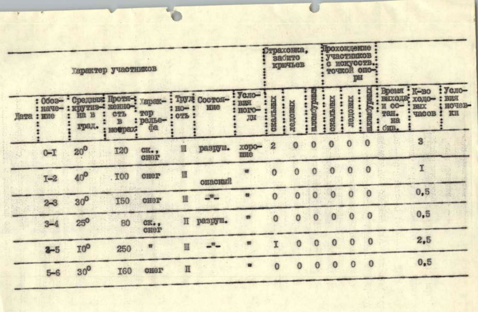
Character of Sections
| Designation | Average steepness in degrees | Length in meters | Character of relief | Difficulty | Condition | Weather conditions | Hammered pitons (rock) | Hammered pitons (ice) | Hammered pitons (bolt) | Passage of artificial terrain obstacles (rock) | Passage of artificial terrain obstacles (ice) | Passage of artificial terrain obstacles (bolt) | Time of departure and stop | Number of travel hours | Overnight stay conditions |
|---|---|---|---|---|---|---|---|---|---|---|---|---|---|---|---|
| R0–R1 | 20° | 120 m | rock, snow | 3 | unstable | good | 2 | 0 | 0 | 0 | 0 | 0 | 3 h | ||
| R1–R2 | 40° | 100 m | snow | 3 | hazardous | 0 | 0 | 0 | 0 | 0 | 0 | 1 h | |||
| R2–R3 | 30° | 150 m | snow | 3 | 0 | 0 | 0 | 0 | 0 | 0 | 0.5 h | ||||
| R3–R4 | 25° | 80 m | rock, snow | 2 | unstable | 0 | 0 | 0 | 0 | 0 | 0 | 0.5 h | |||
| R4–R5 | 10° | 250 m | 1 | 0 | 0 | 0 | 0 | 0 | 2.5 h | ||||||
| R5–R6 | 30° | 160 m | snow | 2 | 0 | 0 | 0 | 0 | 0 | 0 | 0.5 h |
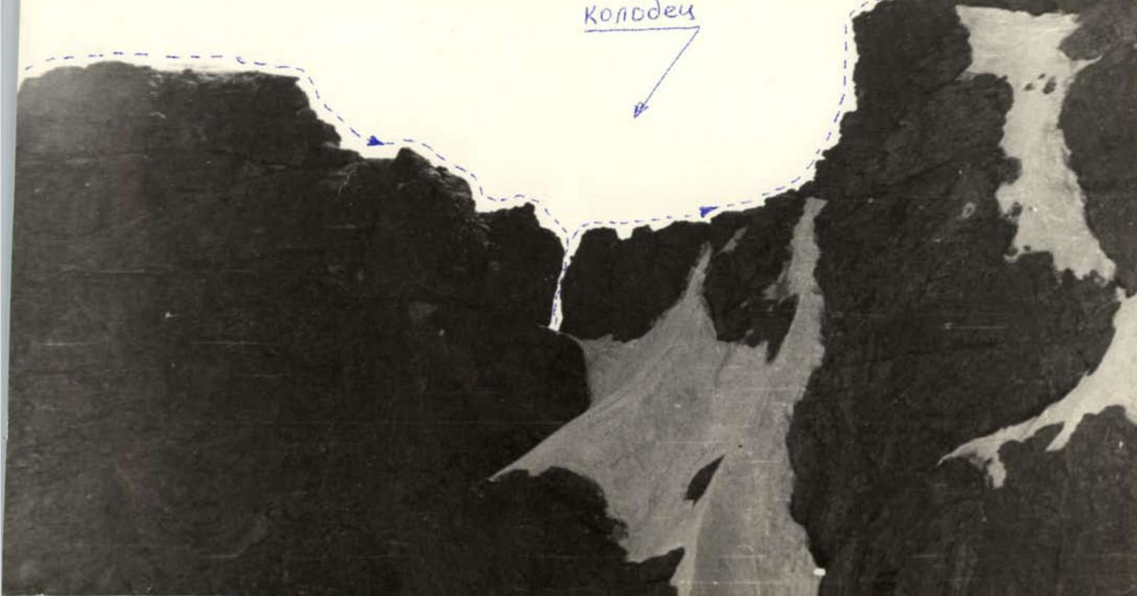
From the first control point located on the saddle of the ridge connecting Kardyvach-Glavnaya peak and Bezymyannye peaks, we move to the right along the ridge. The ridge is wide and snowy, allowing for simultaneous movement. After 3–4 ropes, the ridge becomes more gentle, and cornices appear on the left. It is necessary to hammer a piton into the existing rocky outcrop to approach the "well" (a break in the ridge) with a transverse belay. From the piton to the "well" is 1 rope. At the "well," there are rocky outcrops for organizing belay. Descent into the "well" using the "sports" method and ascent from the "well" directly to the continuation of the ridge. On the opposite side of the "well," there are also outcrops for belay. After 1 rope from the "well," the ridge begins to rise steeply towards the peak. From the gentle part of the ridge upwards, 1 rope goes up the left (with cornices on the right) snowy slope of the ridge with alternate belay. We reach a rocky "island" where there is a place for a piton. From the piton, 1 rope goes along the left side of the ridge to the point where the cornices on the right disappear, and it is possible to move to the right beyond the inflection. Another 2–3 ropes simultaneously to the first peak. On the peak, there is a cairn. Descent from the first peak is along the left side of the ridge (with cornices on the right). To the left, a false ridge diverges. Between the I and II peaks, there is a simple but steep snowy ridge. On the II peak, there is a control cairn. After the II peak, movement is along a rocky, heavily dissected ridge. Belay is simultaneous. To the right, there are sheer drops. After 3 ropes, we reach a snowy "plug" with a large cornice (1 rope). Careful alternate belay through outcrops is necessary. Further, a simple rocky ridge continues to the last "gendarme." The "gendarme" is bypassed on the left. Here, for the organization of sports descent, a piton is hammered. Sports descent (1 rope) bypassing the "gendarme" on the left, then to the right onto a snowy saddle. Further, 3 ropes along the snowy ridge, then down along a steep, indistinct snowy ridge to a rocky "island" (last control cairn). From here, straight down along an open couloir, we return to the snow circus, to the beginning of the route.