Ascent Record
- Ascent category: technically challenging
- Ascent area, ridge: Western Caucasus, Main Caucasian Range, Awadkhara area
- Peak, its height, ascent route: Adzhara peak, 2960 m, route via the south-eastern ridge from Adzhara pass
- Estimated difficulty category: 2A
- Route characteristics: rocky ridge, height difference from the pass to the summit 350 m, average slope 30°
- Pitons driven: for belay : for creating artificial footholds
| Rock | 1 |
| Ice | – |
| Bolt | – |
- Number of climbing hours — 9 hours
- Number of nights and their characteristics — the group did not have nights on the route, there are convenient places for bivouac in the circus.
- Surname, name, and patronymic of the group leader, participants, and their sports qualification:
- Smerchanskaya Svetlana Vladimirovna 3rd sports category
- Shatov Vladimir Ivanovich — participant
- Tikhonov Viktor Nikolaevich — participant
- Grishchutin Sergey Sergeevich — participant
- Isachenko Leonid Ivanovich — participant
- Team coach: Antipin Vladimir Mikhailovich
- Date of departure on the route and return — May 4, 1977.
Route Description
From the bivouac, along the edge starting from the clearing, exit onto a wide, simple ridge and, after passing the lowering, approach the rocky outcrops (1 hour). Traverse left along the slope of the ridge below the rocks and along the steep snow — exit to the second step of the circus (1 hour). Cross the wide mulda and move up the slope, bypassing the "ram's foreheads" on the left to the next mulda. Along it, to the right — exit to the pass. To the first ascent along the wide steep snow, bypassing the rocky outcrops on the left (1 hour). From the pass, move on the right side of the ridge along the shelves, then along the simple rocks — exit to the ridge (2 ropes) under the first wall. The wall is passed in the left part along the inner corner (6–8 m, piton for belay). Further up the ridge and exit to the right onto a horizontal rocky site under the second wall. The wall is bypassed on the right along the shelves (0.5 ropes) and along the steep simple rocks (0.5 ropes) — exit to the ridge. The path along the ridge to the inclined slab under the gendarme. The gendarme is bypassed on the left along the shelves and steep snow (1.5 ropes). Further up along the inclined slabs (loose rocks). Moving to the upper part of the snowy couloir, along the sheer wall (2 m) — exit to the summit (1.5 ropes). From the pass to the summit 2.5–3 hours.
Descent along the ascent route with alternating belay for ledges. On the walls, sport descent, the last one descends by climbing with lower belay. From the summit to the pass 1.5–2 hours. From the pass, descent along the ascent route to the bivouac.
The duration of the route from leaving the bivouac to returning to it is 9 climbing hours.
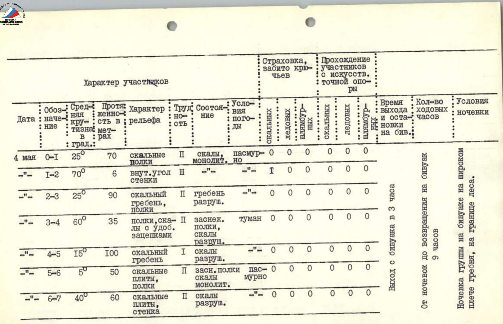
| Date | Section designation | Average slope, ° | Length, m | Terrain characteristics | Difficulty | Condition | Weather conditions | Belay, rock pitons driven | Belay, ice pitons driven | Belay, bolt pitons driven | Participants' passage: rock | Participants' passage: ice | Participants' passage: bolt |
|---|---|---|---|---|---|---|---|---|---|---|---|---|---|
| May 4 | R0–R1 | 25 | 70 | rocky shelves | 2 | rocks, monolith, but | cloudy | 0 | 0 | 0 | 0 | 0 | 0 |
| – | R1–R2 | 70 | 6 | inner corner of the wall | 3 | – | – | 1 | 0 | 0 | 0 | 0 | 0 |
| – | R2–R3 | 25 | 90 | rocky ridge, shelves | 2 | ridge destroyed | – | 0 | 0 | 0 | 0 | 0 | 0 |
| – | R3–R4 | 60 | 35 | shelves, rocks with convenient handholds | 2 | snowy shelves, rocks destroyed | fog | 0 | 0 | 0 | 0 | 0 | 0 |
| – | R4–R5 | 15 | 100 | rocky ridge | 1 | rocks destroyed | – | 0 | 0 | 0 | 0 | 0 | 0 |
| – | R5–R6 | 5 | 50 | rocky slabs, shelves | 2 | snowy shelves, rocks monolith. | cloudy | 0 | 0 | 0 | 0 | 0 | 0 |
| – | R6–R7 | 40 | 60 | rocky slabs, wall | 2 | rocks destroyed | – | 0 | 0 | 0 | 0 | 0 | 0 |
Departure from the bivouac at 3:00. From the bivouac to returning to the bivouac 9 hours. The group's bivouac on a wide shoulder of the ridge, on the edge of the forest.
Adzhara peak is located in the Main Caucasian Range to the north-east of Lake Ritsa in the upper reaches of the Lashipse River. Three ridges lead to the summit: Northern, Western, and South-Eastern. Mild weather conditions, convenient access roads, relatively short approaches, as well as the presence of classification routes in the area make the summit interesting in terms of mountaineering.
In the valley of the Awadkhara River, in the former houses of the geological exploration party, the base camp of the Abkhazian Republican Federation of Mountaineering (ARFM) and the field KSP of the Awadkhara gorge were organized.
From the Awadkhara sanatorium, a logical path to Adzhara peak is visible along the south-eastern ridge from Adzhara pass, approximately 2nd category of difficulty.
The first ascent to Adzhara peak along the south-eastern ridge from Adzhara pass was made by a sports group of the ARFM mountaineering event consisting of:
- Smerchanskaya S.V. 3rd sports category — leader
- Shatov V.I. — participant
- Tikhonov V.N. — participant
- Grishchutin S.S. — participant
- Isachenko L.I. — participant
The group left the base camp on May 3, 1977, at 15:00 along the road to the Awadkhara sanatorium, then along the logging road along the right (orographic) bank of the Lashipse River and stopped at a bivouac on the shoulder of the ridge leading to Adzhara pass at 18:00. The ascent route was viewed and photographed from the circus. The ascent was made on May 4, 1977, in full force in variable weather. Departure from the bivouac at 3:00. The following equipment was used during the ascent:
- Personal equipment
- Main rope 2 × 40 m
- Rock pitons 6 pcs.
- Expendable carabiners 4 pcs.
- Rock hammers 2 pcs.
- Tent, primus stove (in case of bad weather)
- R/s "Vitalka" 1 pc.
Descriptions of approaches to the route, the ascent route, necessary diagrams, tables, and illustrations are given below.
On May 8, 1977, the route was repeated in more difficult weather conditions by a sports group of the ARFM mountaineering event consisting of:
- Gorbunov M.D. — leader
- Gladyshev V.A.
- Semykin B.I.
- Muzykin B.V. and rated as a 2B category route.
Brief Description of the Approach to the Route
From the base camp along the road down to the Awadkhara sanatorium. Then along the right (orographic) bank of the Lashipse River along the old logging road, which ends at a clearing. At the end of the clearing — koshi, behind the koshi cross the stream and exit to the second clearing.
To the left along the course is a wide grassy slope, free from forest.
Up the slope with an exit to the left onto a wide treeless shoulder of the ridge (on the edge of the forest). Here is a convenient place for a bivouac. From the base camp to the bivouac 2–2.5 hours.
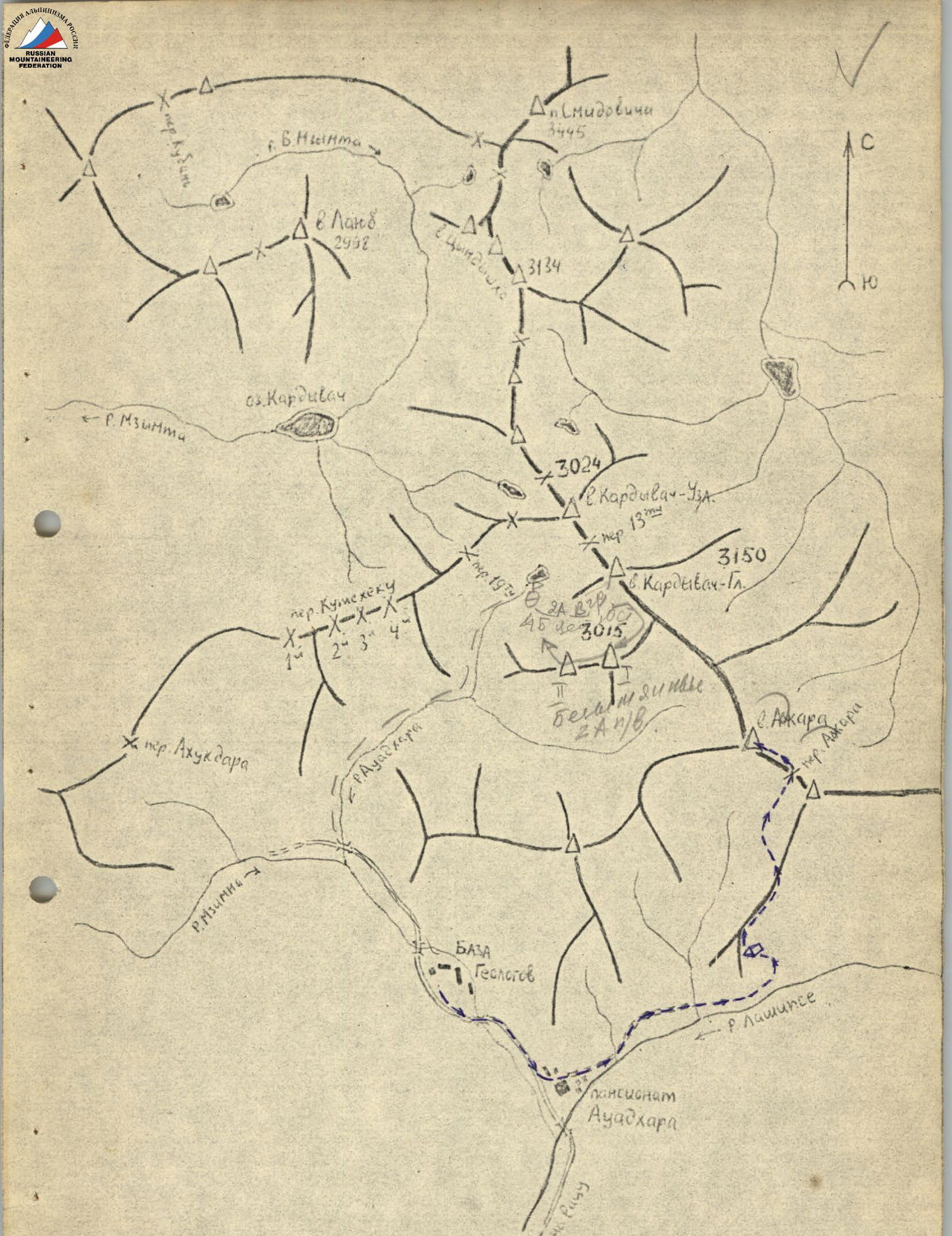 Map of the ascent area.
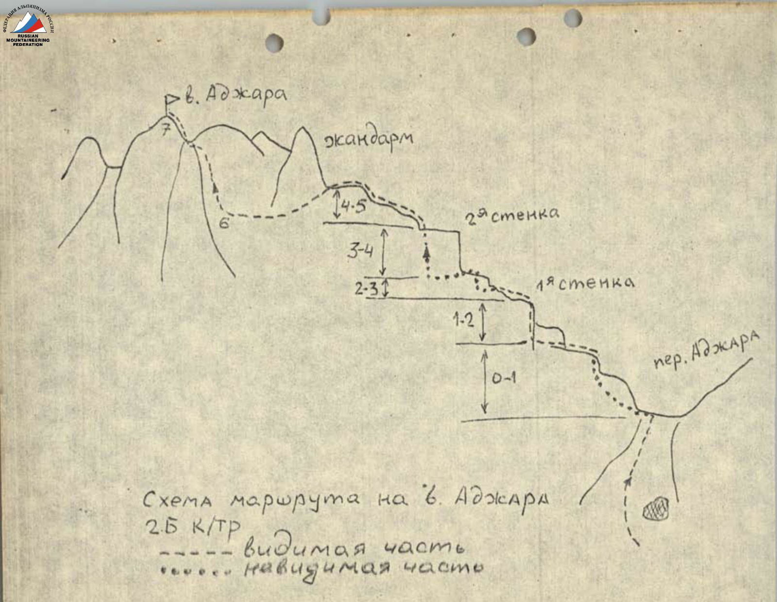 Route diagram to Adzhara peak 2B category. Visible part: ----- Invisible part: ......

