
Report on the First Ascent to Sokol Peak via the "Levee Grebnevoy Dvoiki" Route 3A/3B Category by the UTS FANO "Krym-23" Team for the Period from 01.05.2023 to 08.05.2023
I. Ascent Passport
| № | 1. General Information | |
|---|---|---|
| 1.1 | Full Name, Sports Rank of the Leader | Patutinskiy Alexander - 1st sports rank |
| 1.2 | Full Name, Sports Rank of the Participants | Gogolev Stepan - 3rd sports rank, Roitmay Sofya - 2nd sports rank |
| 1.3 | Full Name of the Coach | Bogdanov Alexey Vladimirovich |
| 1.4 | Organization | Federation of Alpinism of Nizhny Novgorod Region |
| 2. Characteristics of the Ascent Object | ||
| 2.1 | Region | Crimea |
| 2.2 | Gorge | Sokol Mountain |
| 2.3 | Number according to the 2020 Classification Table | 10.10 |
| 2.4 | Name and Height of the Peak | Sokol 473 m above sea level |
| 2.5 | Geographical Coordinates of the Peak (latitude/longitude), GPS Coordinates | - |
| 3. Characteristics of the Route | ||
| 3.1 | Name of the Route | "Levee Grebnevoy Dvoiki" |
| 3.2 | Proposed Category of Difficulty | 3A–3B |
| 3.3 | Degree of Route Development | First Ascent |
| 3.4 | Nature of the Route Relief | Rocky |
| 3.5 | Height Difference of the Route (altimeter or GPS data) | 210 m |
| 3.6 | Length of the Route | 310 m |
| 3.7 | Technical Elements of the Route (total length of sections of varying difficulty with relief characteristics) | 1st cat. diff. rocks - 20 m, 2nd cat. diff. rocks - 130 m, 3rd cat. diff. rocks - 70 m, 4th cat. diff. rocks - 80 m, 5th cat. diff. rocks - 10 m |
| 3.8 | Descent from the Peak | Via descent paths to Novy Svet or Sudak |
| 3.9 | Additional Route Characteristics | Many loose small stones, hazardous in heavy rain |
| 4. Characteristics of the Team's Actions | ||
| :--: | :--: | :--: |
| 4.1 | Time of Movement (team's walking hours, in hours and days) | 7 hours |
| 4.2 | Overnight Stays | Sudak CSS |
| 4.3 | Departure onto the Route | 9:30, 08.05.2023 |
| 4.4 | Arrival at the Peak | 15:00, 08.05.2023 |
| 4.5 | Return to the Base Camp | 16:30, 08.05.2023 |
| 5. Responsible for the Report | ||
| 5.1 | Full Name, e-mail | Patutinskiy A.N. aleks_patutinskii@mail.ru |
II. Ascent Description
1. Characteristics of the Ascent Object
1.1. General Photo of the Peak.
Photo from GuideBook.
Yellow - team's route.
Components of the route:
- 3 — PDPV
- 4 — Hanging Gardens
- 5 — "Grebnevaya Dvoika"
1.2. Profile of the Route.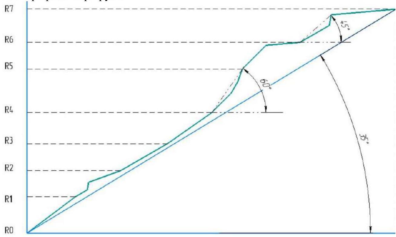
1.3. Photopanorama of the Area.
Taken from the page (Sergey Nadtochiy)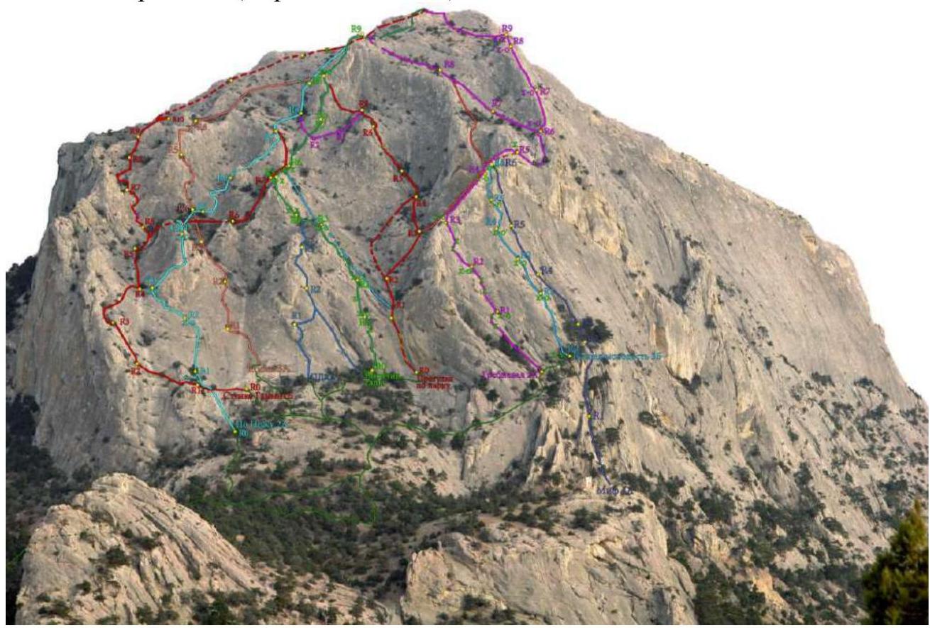
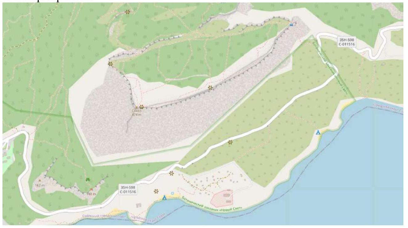
1.4. Map of the Area
2. Characteristics of the Route
2.1. Technical Photograph.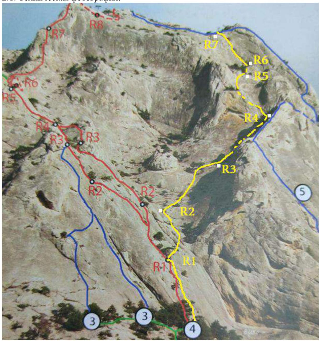
2.2. Technical Characteristics of Route Sections.
| Section № | Relief Characteristics | Cat. Diff. | Length, m | Type and Number of Pits |
|---|---|---|---|---|
| R0–R1 | Cascade of inclined slabs broken by cracks with bushes and trees | IV–/IV+ | 45 m | 3 anchors + 1 stopper + points on trees |
| R1–R2 | Inclined slab, cascade of 2 walls 1.5–2 m high, inclined slabs with cracks | IV, IV+, II+ | 10 m, 5 m, 25–30 m | 3 anchors + point on a tree |
| R2–R3 | Inclined slab | II | 50 m | 1 anchor + point on a tree |
| R3–R4 | Inclined slab | II+/III | 50 m | 1 anchor + point on a tree |
| R4–R5 | Inclined slab turning into an internal corner. Movement along a crack with an exit to a ledge bypassing a small overhang | III, IV, V, no protection | 20 m, 10 m, 10 m, 3 m | 4 anchors + 4 friends + 2 stoppers + points on trees |
| R5–R6 | Ledge, inclined slab broken by cracks | no protection, III+ | 25 m, 25 m | 3 anchors |
| R6–R7 | Oblique ledge, internal corner, ledge | III, IV, I | 25 m, 8 m, 12 m | 3 anchors + 2 friends |
| R7–R8 | Inclined slab | no protection | 80 m | 0 |
2.3. UIAA Scheme.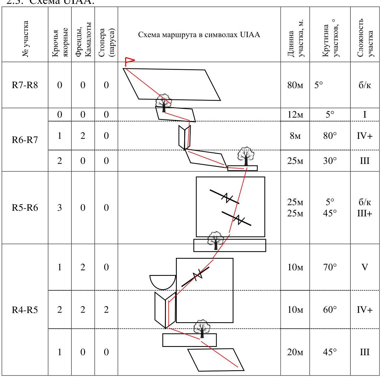
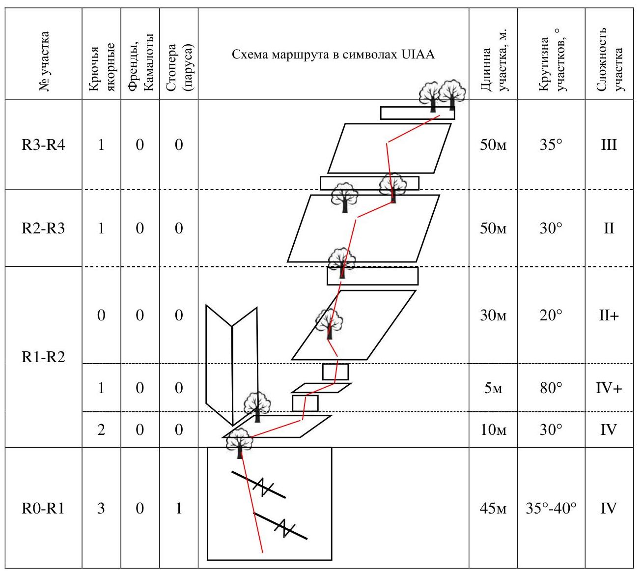
| Section № | Anchor Pits | Friends, Camalots | Stoppers (sails) | Route Scheme in UIAA Symbols | Section Length, m | Section Steepness, ° | Section Difficulty |
|---|---|---|---|---|---|---|---|
| R7–R8 | 0 | 0 | 0 | 80 m | 5° | no protection | |
| R6–R7 | 0 | 0 | 0 | 12 m | 5° | I | |
| 1 | 2 | 0 | 8 m | 80° | IV+ | ||
| 2 | 0 | 0 | 25 m | 30° | III | ||
| R5–R6 | 3 | 0 | 0 | 25 m | 5° | no protection | |
| 25 m | 45° | III+ | |||||
| R4–R5 | 1 | 2 | 0 | 10 m | 70° | V | |
| 2 | 2 | 2 | 10 m | 60° | IV+ | ||
| 1 | 0 | 0 | 20 m | 45° | III | ||
| R3–R4 | 1 | 0 | 0 | 50 m | 35° | III | |
| R2–R3 | 1 | 0 | 0 | 50 m | 30° | II | |
| R1–R2 | 0 | 0 | 0 | 30 m | 20° | II+ | |
| 1 | 0 | 0 | 5 m | 80° | IV+ | ||
| 2 | 0 | 0 | 10 m | 30° | IV | ||
| R0–R1 | 3 | 0 | 1 | 45 m | 35°–40° | IV |
3. Characteristics of the Team's Actions
3.1. Brief Description of the Route Passage.
The route is interesting and logical. Climbing is uneven with a pronounced crux at section R4–R5. Friction climbing on slabs prevails.
The cruxes R4–R5 and R6–R7 are suitable for preparation for 4A routes. The route is recommended for teams with a strong climbing level: III/III+ category for each participant, V category for the leader. Recommended movement scheme: independent teams or "team by team". The route is located in the Sokol sector facing Novy Svet. The line is clearly visible during the passage of "Grebnevaya Dvoika".
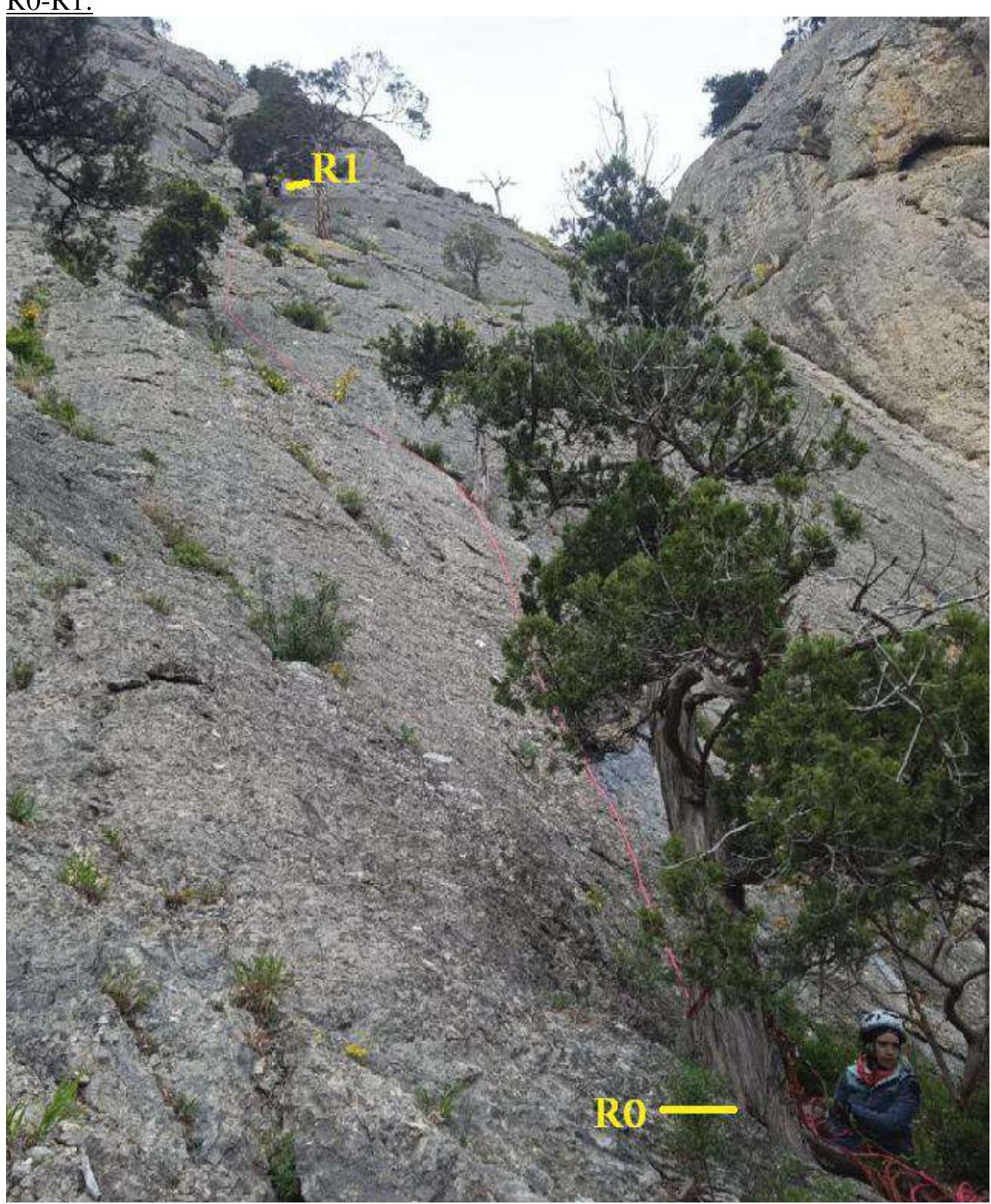
R0–R1:
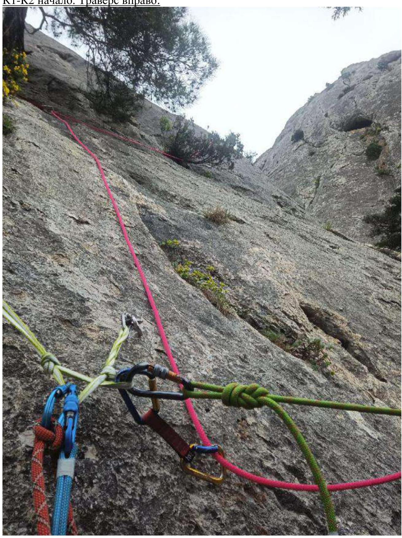
R1–R2 start. Traverse right:
View from the middle of R1–R2:
View from R2 to R2–R3–R4:

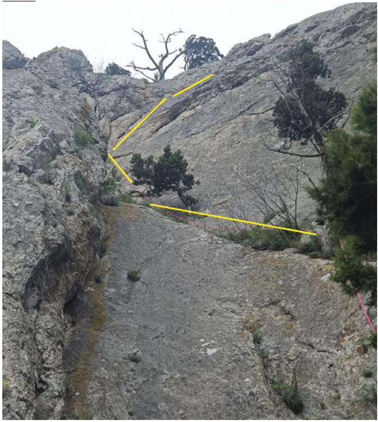
R4–R5:
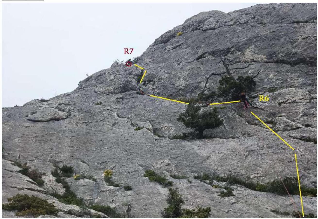
R5–R6–R7:
| Section № | Description | Photo Number |
|---|---|---|
| R0–R1 | R0 - station on a tree. Movement along an inclined slab cut by cracks with bushes and trees. R1 - station on a tree - common with the "Hanging Gardens" route | R0–R1 |
| R1–R2 | From R1, traverse right, rising slightly. You can make a point on a tree above the station and swing the leader to the right. Then, through 2 bends, go to the lower part of the right wall of the hanging bowl. After passing the bends - many loose stones. Move up the bowl to R2. It is possible to make R2 closer (no need to go the whole rope length) for better audibility from R1. In any case, R2 is on a tree | R1–R2 start. Traverse right. View from the middle of R1–R2 |
| R2–R3 | Movement up the bowl to the right along the ridge of "Grebnevaya Dvoika" the whole rope length. Climbing on gentle mossy slabs. Many small stones. Dangerous in rain | View from the middle of R1–R2 |
| R3–R4 | R3 - on a tree. Continue moving along the slabs along the ridge to the right and up. R4 - on a tree | View from R2 to R2–R3–R4 |
| R4–R5 | Along an oblique ledge, go left and up, enter an internal corner. Up the corner and to the right, bypass a small overhang in a grasp. Exit to a ledge. R5 - on a tree. Large friends (BD №2, 3) and extenders will come in handy | R4–R5 |
| R5–R6 | Horizontal ledge overgrown with juniper. Inclined slab broken by cracks. There are live attachments - climbing holds, no points. Insurance with anchors. R6 - on a tree | R5–R6–R7 |
| R6–R7 | From the station, move left and up along an inclined ledge through 2 juniper bushes. Enter an internal corner. Up the corner. In the upper part of the corner, shift slightly to its right side. The relief rises, but there are good "handholds". Exit to a ledge. R7 - on a tree | R5–R6–R7 |
| R7–R8 | 80–100 m no protection in the direction of the peak | - |
3.2. Photo of the Team at the Peak near the Control Tour.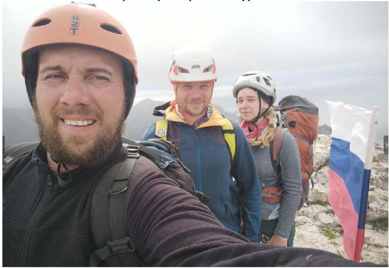
3.3. On the route sections passing through the bowl (from the 2nd half of R1–R2 to R4), there are many loose small stones, and these sections are also hazardous in heavy rain, as the bowl is a catchment area from the neighboring slopes, which have many stones.
Descent from the route:
- Via the path to Novy Svet from the back side of the mountain.
- Via the path to Sudak from the back side of the mountain.
The route turned out to be much more complicated than 3A "Chico", similar in difficulty to 3B "Istukan". Key sections correspond to the cruxes of 3B, the overall level of the technical part of the route corresponds to 3A/3B in rocky areas.
Comments
Sign in to leave a comment