
Crimea. Kush-Kaya. First Ascent 2A "Krasny Ugol"
Alpinism. Written by Volikov, April 3, 2014, 0:18
We arrived in January in Crimea at the Kush-Kaya mountain massif with mountaineering objectives:
- to do some climbing;
- to gain guiding experience;
- to hone our skills with "iron". Actually, we came to celebrate the New Year, drink wine, and take a dip in the winter sea. Nothing out of the ordinary was expected. But... everything is available on Kush-Kaya, except for a 2A route. So, we started looking for another "double", and this is what came out of it.
Ascent Passport
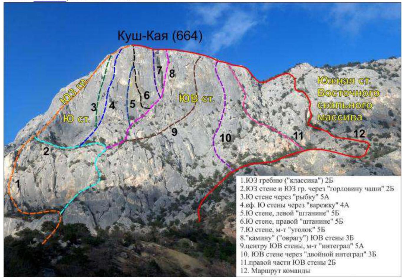
- Section number according to KMGV - 8.2. Crimean Mountains, Batiliman, Kush-Kaya mountain massif.
- Name of the peak: Kush-Kaya.
- Height: 664 m.
- Route: via the southern wall of the eastern rock massif "Krasny Ugol".
- Category of difficulty: assumed - 2A-2B cat. diff.
- Route character - rock climbing.
- Height difference of the route: 396 m.
- Route length: 940 m.
- Length of sections with the highest cat. diff.:
- 1 cat. diff. - 6 sections - 115 m;
- 2 cat. diff. - 3 sections - 185 m;
- 3 cat. diff. - 5 sections - 48 m;
- 4 cat. diff. - 2 sections - 40 m;
- 5 cat. diff. - 0 sections;
- 6 cat. diff. - 0 sections - 0 m.
- Average steepness: wall part of the route - 46°, entire route - 26°.
- Pitons used. Total on the route: rock pitons - 2 points, camalots - 16 points, chocks - 0, stationary pitons - 0, ITO - 0 points, removable pitons - 0. Left "pitons" on the route: total - 1 (including pitons - 0, chocks - 0).
- Start of the route - 6:00, January 6, 2014. Reached the summit - 15:00, January 6, 2014. Returned to BL - 17:00, January 6, 2014.
- Team's climbing hours: 11 hours.
- Leader: Volikov Alexander Borisovich (2nd sports category, Moscow region). Participants: Karaulova Tatyana Igorevna (2nd sports category, Moscow).
- Coach: Zhuravlev Sergey Vasilyevich, title - CMS, 1st category instructor-methodologist.
Route Description
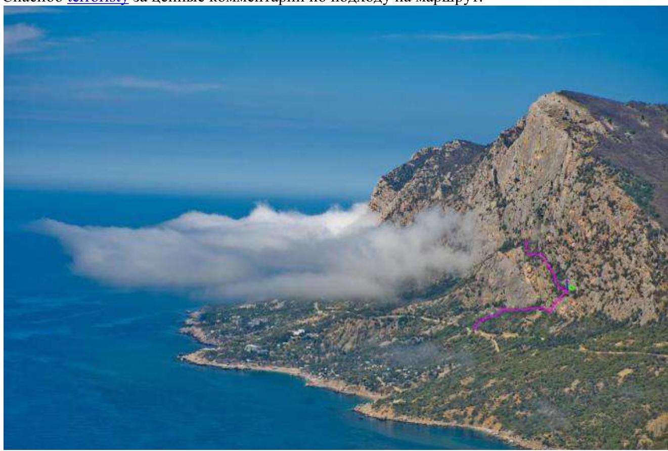
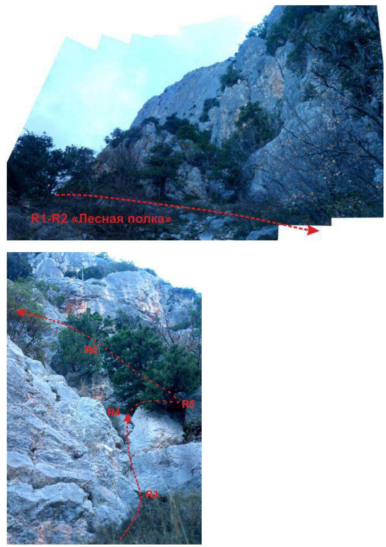
Approach. From the road at the Kush-Kaya campsite parking lot, follow the marked trail towards the campsite. Before reaching the campsite, turn right according to the signs towards the "Burevestnik" rock massif. Multiple trails lead to the slope; you can reach it in different ways. Along the slope, a trail runs which is used to access the route, approximately 100 m to the left of "Burevestnik". There are different ways to start the route; there is no single trail. The route begins with an ascent to the "Lesnaya Polka" above the "Burevestnik" rock massif. Along it, proceed along the slope to the right to a poorly defined couloir. After the couloir, continue another 50 m to the start of the wall part of the route.
Alternative approach to the route:
- From the "Burevestnik" inscription on the retaining wall to the right of the road (without T) head up the trail to the ledge under Burevestnik.
- Then head right along the trail, parallel to the wall, 100 m (to the rocky chaos under the cliffs), where the trail turns left towards the cliff.
- Then, via ledges, reach a small wall about four meters high, with a stone structure on top.
- Previously, a rope with knots hung from a tree behind the structure.
- If climbing the wall without ropes, the difficulty is around 5B-5B+; don't be fooled by this simplicity - there have been falls here.
- After the tree, move right and up about 15 m to a wide ledge where a house once stood (mentioned by terrorist at 9:40, April 3, 2014).
- The house burned down, but the fire traces on the rocks remain.
- To the left, you can see the pitons of the Rossia Crazy 6B route (possibly an error - haven't been there in a while).
- From this ledge, head left with a slight ascent along a wide inclined ledge.
- After about 100 m, this ledge will lead to R3.
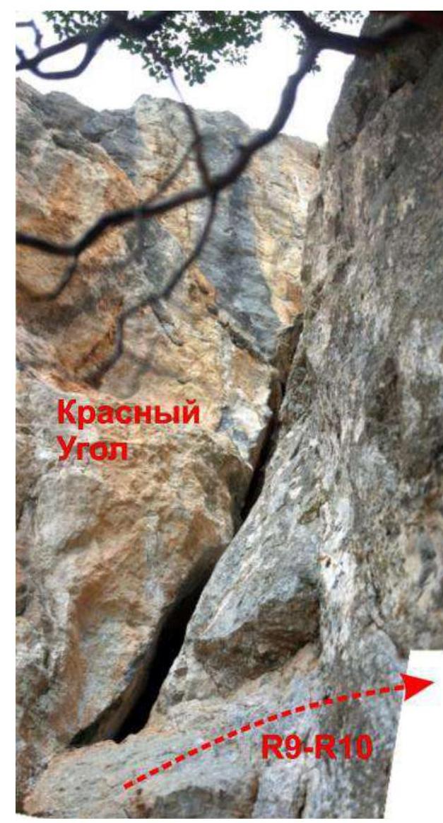
Technical part. Start of the wall. The landmark is two red breaks on the wall 30 m above the ground; the wall part begins under the left one. On the wall, move left to a large internal angle via ledges. Passing this part of the route is not challenging; insurance is mostly provided by trees. Passing a series of ledges and short walls, you reach "Krasny Ugol". Then, move right and up via simple ledges to a pine tree and from there up to the key section of the route.
The crux of the route - a gently sloping rock wall with minimal features and minimal relief for organizing intermediate belays:
- From the tree, move up, then left to the internal angle.
- Insurance is problematic here - there are practically no cracks; anchor pitons can be used.
- The route then follows along the internal angle.
- At this section, insurance is possible using friends (preferably large sizes) in the crack of the internal angle or with anchor pitons on the slabs.
- Climbing at the crux requires good balance and attention since there are practically no active holds.
- At the top of the crux, there are several trees where a station can be set up.
After passing the crux:
- Exit to the ledges above "Krasny Ugol", climbing left and up.
- From the ledge, climb simple rocks (about 100 m) to reach the yayla.
- From the yayla, left along a good trail to the summit.
Alternative approach. Photo by Sergey Nefedov with corrections by user dhu.
Thanks to terrorist for valuable comments on the approach to the route.
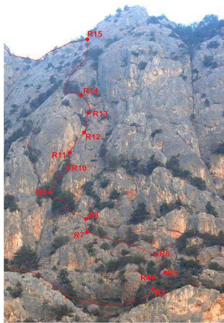
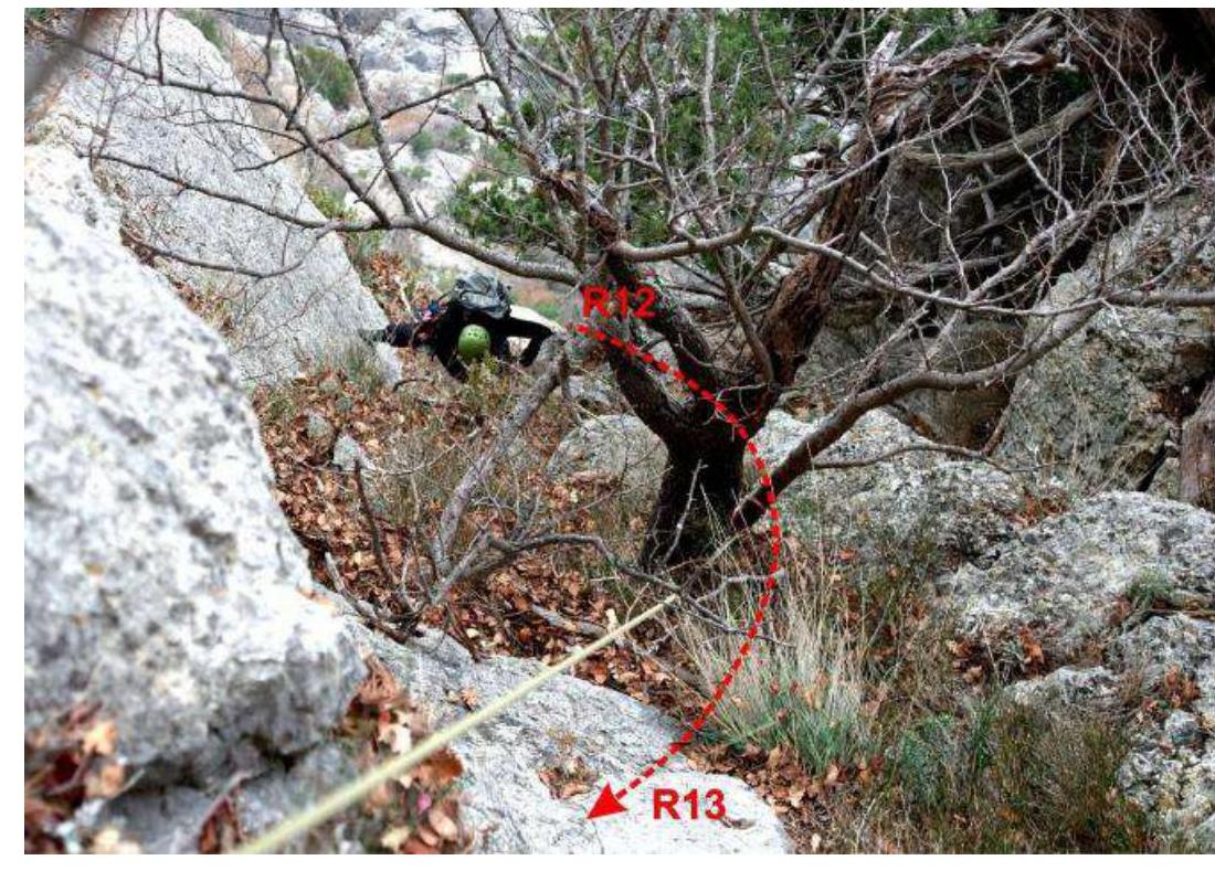
 Technical photo of the wall part of the route.
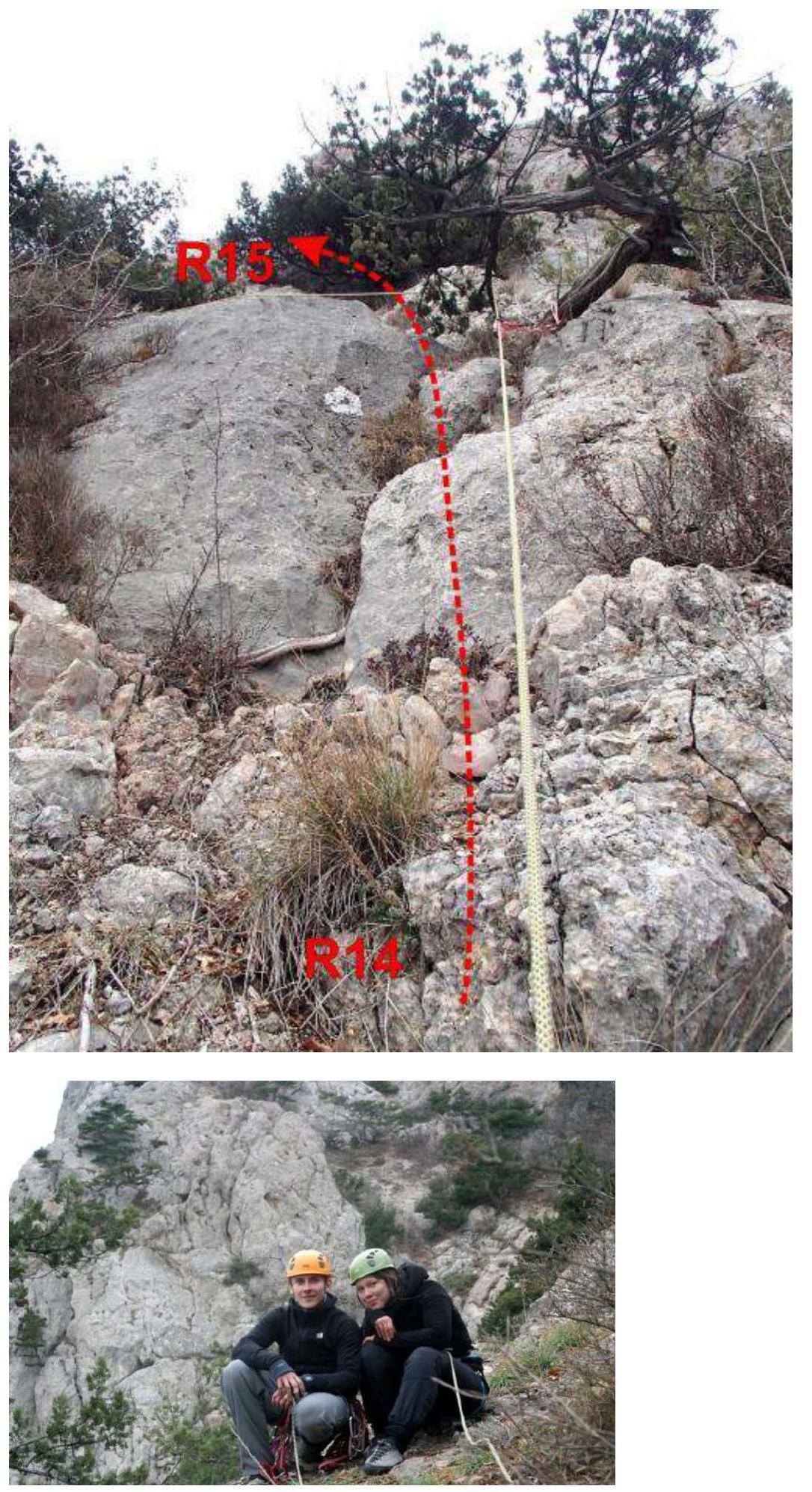
UIAA Scheme
Description by Sections
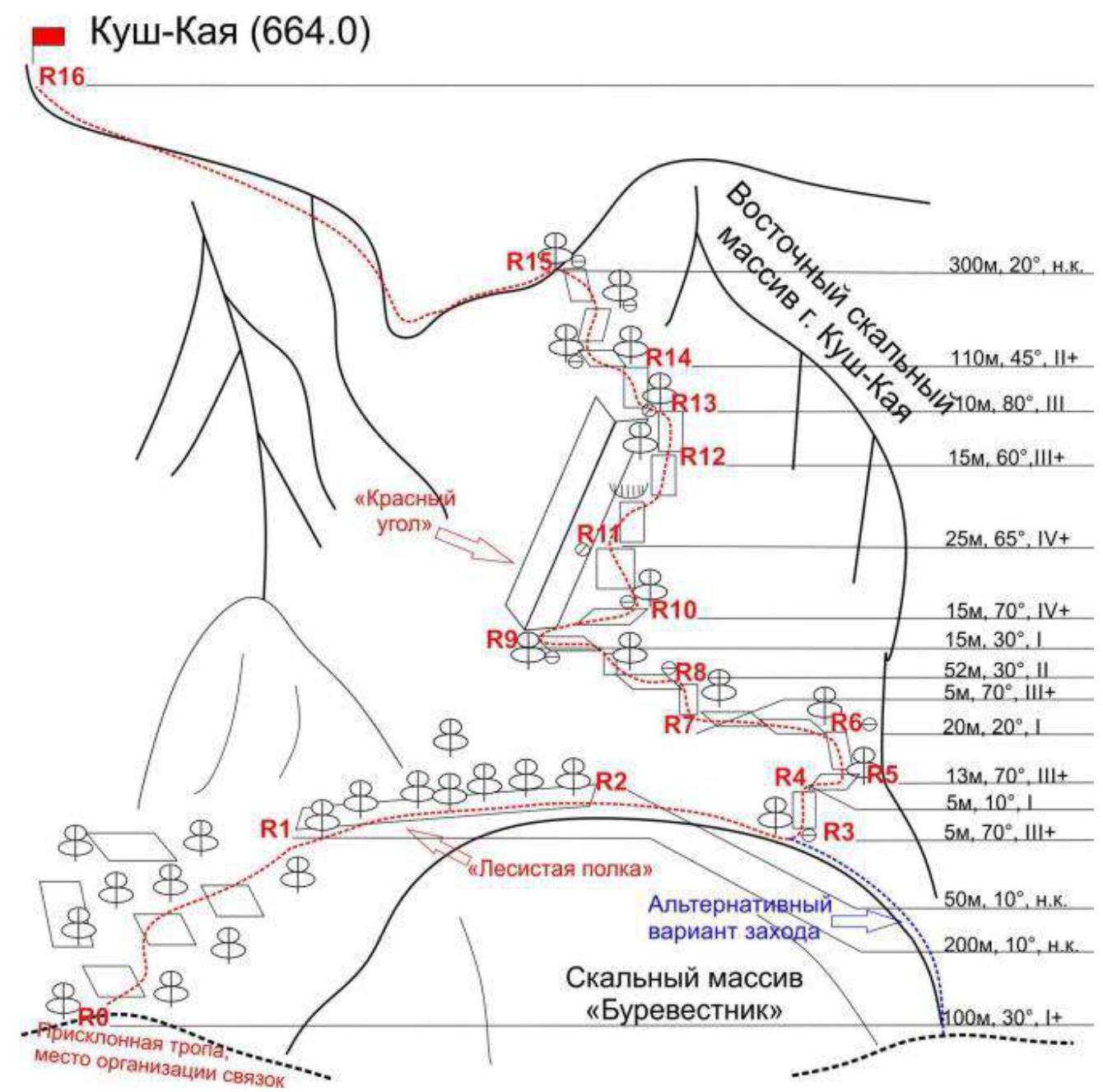
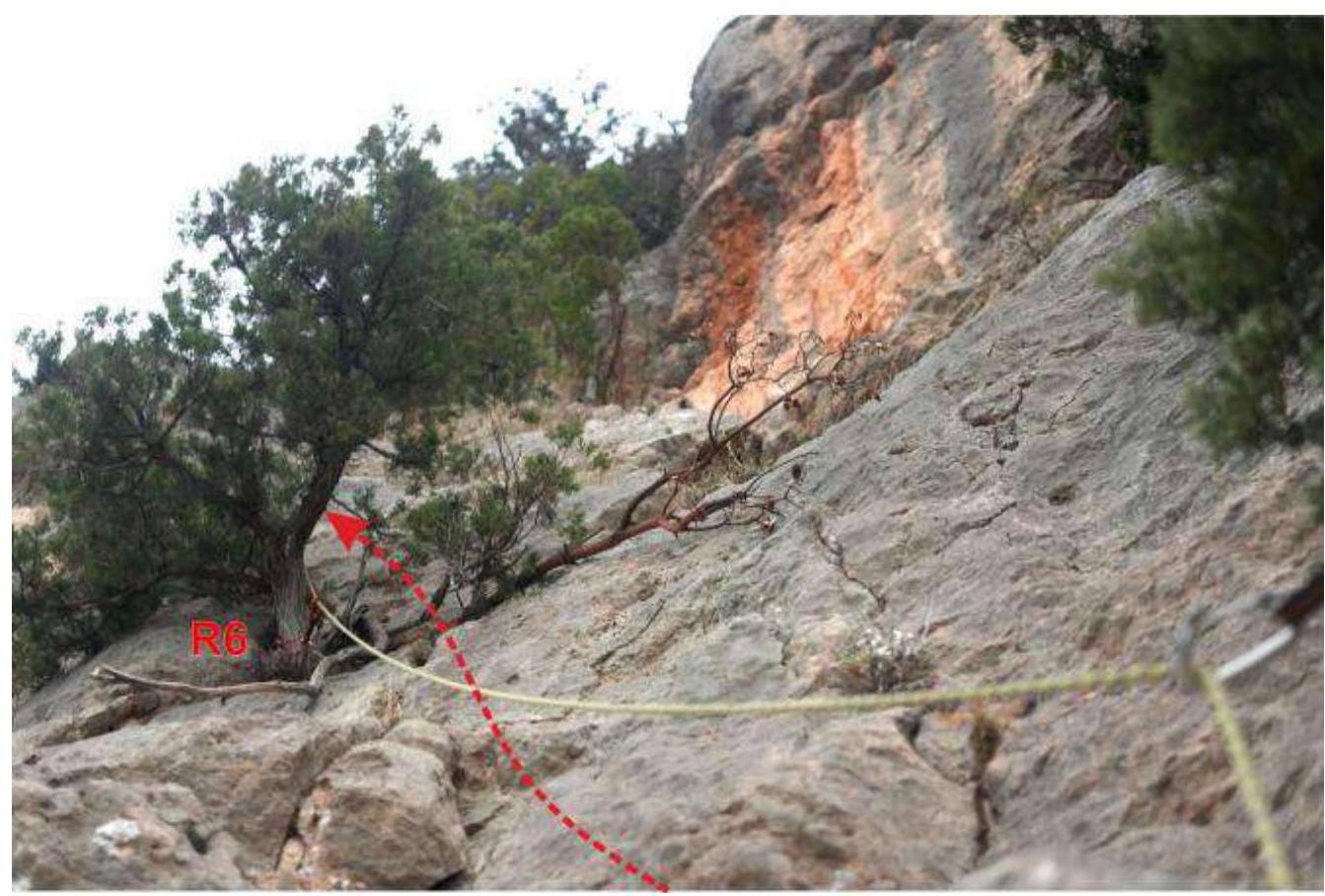
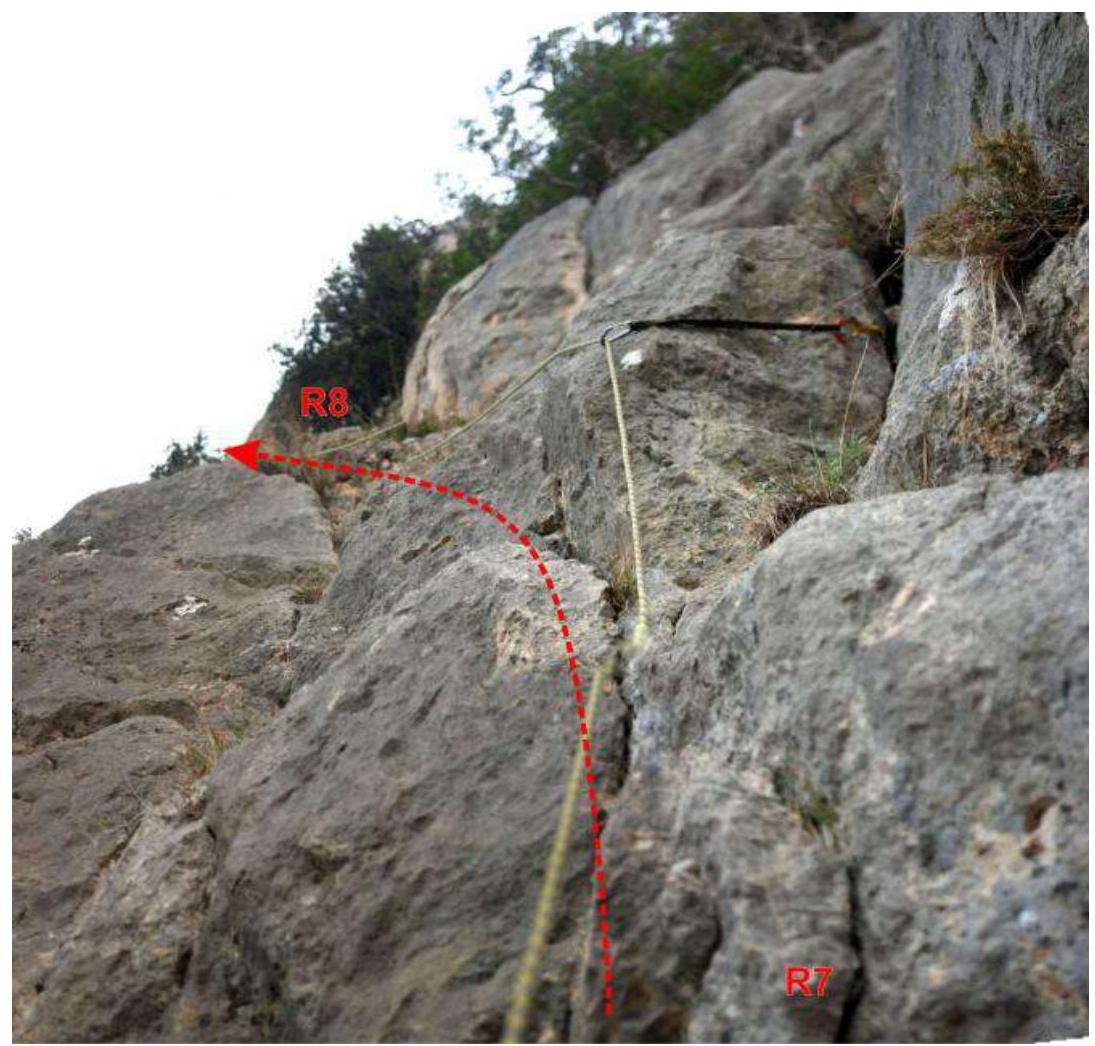
R0 - a place on the trail to the left (in the direction of travel) of the "Burevestnik" rock massif. R0-R1 - ascent to "Lesnaya Polka". Tree-covered rocks. I-II, 100 m, 30°. Simultaneous movement. R1-R2 - traverse along "Lesnaya Polka". A ledge with many large trees. NC, 200 m, 10°. Simultaneous movement. R2-R3 - traverse of a scree couloir. Scree. 50 m, 10°. Simultaneous movement. Alternative approach: "Section R0-R1 is not safe. This section can be safely bypassed via the classic path, hanging a top rope on Burevestnik. From under the ledges under Dazdrapermayskogo, go under the cliffs along the trail to the right, then climb simple rocks to the ledge with the burned-down house (also a rock climbing route 'Russkiy Bezumets'), from there along the ledge left and up to R3. Both shorter and safer". R3-R4 - beginning of the technical part of the route. A rock wall with a crack, III, 5 m, 70°. 1 camalot. Station on a tree. R4-R5 - traverse to the right. Rock ledge. I, 5 m, 10°. Station on a tree. R5-R6 - first wall. Up a steep wall with a system of cracks to the left. III, 13 m, 70°. 1 chock. Station on a tree. R6-R7 - traverse "Two Ledges" left to a tree. I, 20 m, 20°. R7-R8 - passing a rock wall. III, 5 m, 70°. 1 camalot. Station on a tree. R8-R9 - traverse of two rock ledges separated by a 7-meter wall-threshold (II+, 40°). I-II, 50 m, 30°. Station on a tree. R9-R10 - passing non-steep inclined slabs to the right of "Krasny Ugol". I, 15 m, 30°. Station on a tree. R10-R11 - a smoothed wall without active holds and features, without microrelief for intermediate belays. Climbing on friction, complex organization of intermediate belays. IV, 15 m, 70°. Station in the corner on 3 camalots (No. 2, 3, 4). R11-R12 - a smoothed wall without active holds and features, insurance in the crack of the internal angle. Climbing along the angle, then to the right from under the ledge. Large camalots work well. IV, 25 m, 70°. 4 camalots, 1 anchor. R12-R13 - inclined, smoothed wall, III+, 15 m, 60°. 2 anchor pitons, one left on the route. Station on a tree. R13-R14 - exit to a rock ledge above "Krasny Ugol" via a wall up from a tree. III+, 10 m, 80°. Station on a tree. R14-R15 - exit to the yayla of the mountain. Slabs with abundant microrelief. II+, 110 m, 45°. Insurance and stations on trees. R15-R16 - ascent along the trail to the summit. 300 m.
Personal Impressions
When I came to Crimea, I didn't think about doing a first ascent. Probably because my partner and I are two "green" second-category climbers. And yet, we were entrusted with such a task. But we enjoyed it! Beforehand, we spent a long time examining the route thread through binoculars, choosing options, and as a result, we navigated the route much better than on the classic routes we had climbed the day before. We named the route "Via the southern wall of the eastern rock massif", or "Krasny Ugol" for short. The angle might not be entirely red, but rather reddish. But we scouted it during sunset, so this characteristic part of the mountain looked bright red, and the name stuck.
Now about the route. The route is logical. Up to the angle, you can easily move simultaneously. Along the way, there's a lot of bush and other debris. Upon reaching the angle, we really wanted to climb into it immediately; it looks stunning. A wide crack up to 10-20 cm. Climbing on slabs on friction. But for insurance, large camalots are necessary, which we didn't have enough of, so we went along the ledges to the right to a tree, and from there left and up into the angle. At this section, it's challenging to organize insurance; with difficulty, you can find a spot for anchors and ice axes. But climbing is relatively simple on friction. Further along the angle, insurance becomes easier up to the trees at the top of the angle. In principle, on a long 60 m rope, you can climb the entire crux without organizing an intermediate station in the angle. And then, it's a fairly simple exit to the yayla via gentle slabs; you can move simultaneously.
We aimed for 2A; the climbing roughly corresponds. But, objectively speaking, it's more like 2B due to the difficulties with organizing insurance at the crux. We submitted it for classification; we'll see what happens.
I also want to express gratitude to Zhuravlev Sergey Vasilyevich, the organizer and coach of the Sauk-Pai gathering. Without him, this ascent wouldn't have happened. Thanks!
Comments
Sign in to leave a comment