Chelebi — 7
Author: Aleksandr Lavrinenko, Odessa
Chelebi, Crimea. Descriptions of alpinist routes
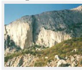
The Chelebi massif is located in the western part of the Main Ridge of the Crimean Mountains, between the "Baidarskie vorota" pass and the Il'yas-Kaya mountain. The relative height is 200 m, the absolute height is 600 m above sea level.
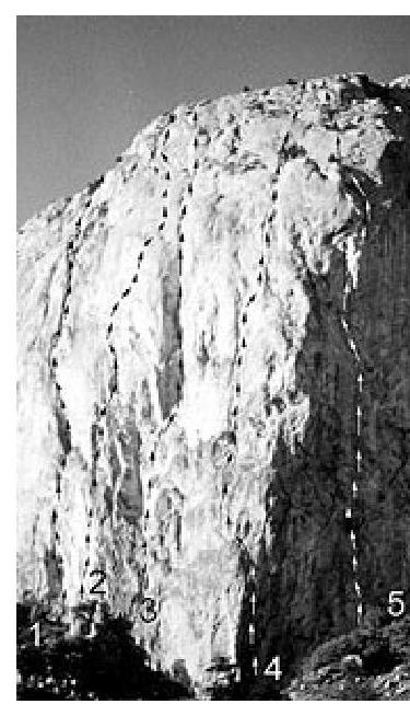
Despite the relatively low height, 5 routes of 5th and 6th category of difficulty have been laid through the central part of the wall. The routes are very popular (for example, the Bershov route, there can be several ascents per day).
Descent from the wall is possible both from the left and from the right. The left path (if looking towards the sea) is shorter:
- Follow the yaila along the cliff towards the Baidar Gates for about 600–700 m.
- Near the descent couloir, there is a group of trees.
- Down the steep scree, then right along the wall.
List of Routes
-
Suslov's route "Strelka" 5B
-
Kruglov's route "Lunokhod" 1999 6A
-
Bershov's route 5B
-
? "Dnepropetrovsky" 6A
-
Verba's route 6A
-
"Kamin" 4A (left variant — 5A)
-
Right wall of "Kamin" 5A — a dangerous route through a "ruin".
-
Popov — Shelkhako's route "Zub" 5B 1999
-
"Kurinaia lapka" 4B
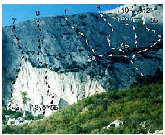 7–12
— routes on the right part of the wall, starting from the "Dvoika"
7–12
— routes on the right part of the wall, starting from the "Dvoika"
- "Flay down" done top-down.
- "Dvoika" 2A
- Pavlov's route "Bol'shoi karniz" 5B, starting from the "Dvoika"
Route Descriptions
In the route descriptions, I used the French classification to indicate the difficulty of free climbing, as it is the most widely used in the CIS.
Sections of artificial technical climbing (ITC) are rated according to the American system, i.e.:
- the difficulty depends on the number of unreliable points,
- the difficulty does not depend on the steepness of the rock.
"Dnepropetrovsky" Route 6A
The start of the route is an inner corner at the junction of the South and Southwest walls. Up the corner, initially by free climbing, then using ITC, 30 m, then along a crack, up and right 10 m. Station on 2 bolts.
40 m, 90°, 6a A3
From the station, left 3–4 m to a crack. Up the crack to a tree. In the lower part, there is difficult climbing and ITC, then it becomes easier. Station on a tree. It is desirable to reinforce the station.
25 m, 80°, 6a A2
From the tree, up a нависающий внутренний угол (overhanging inner corner) 5–7 m using ITC, then by free climbing along an intermittent crack, exit onto a sloping ledge in front of an overhanging inner corner.
20 m, 80°, 6a+
You can make a station, but it's better to continue. Up the inner corner 15 m, then right into another inner corner. Up the corner, right 10 m — exit to a bolt. From the bolt, 5 m right onto a ledge at the base of an inner corner. Station.
55 m, 85°, 6B A3
Up the inner corner through a slight overhang, then along a crack — exit onto a long ledge. Station on a tree.
40 m, 80°, 6A A1
From the tree, slightly left and up an inner corner, then along a slab with shells right-up to a pine tree.
15 m, 70°, V
Then along easy rocks 40 m to the yaila.
Ascent time: 5–7 hours


