Mshatka-Kaya — 14

Hi-Res photo of Mshatka-Kaya "Ryzhiy vyval" ("Red landslide") — the green line on the photograph
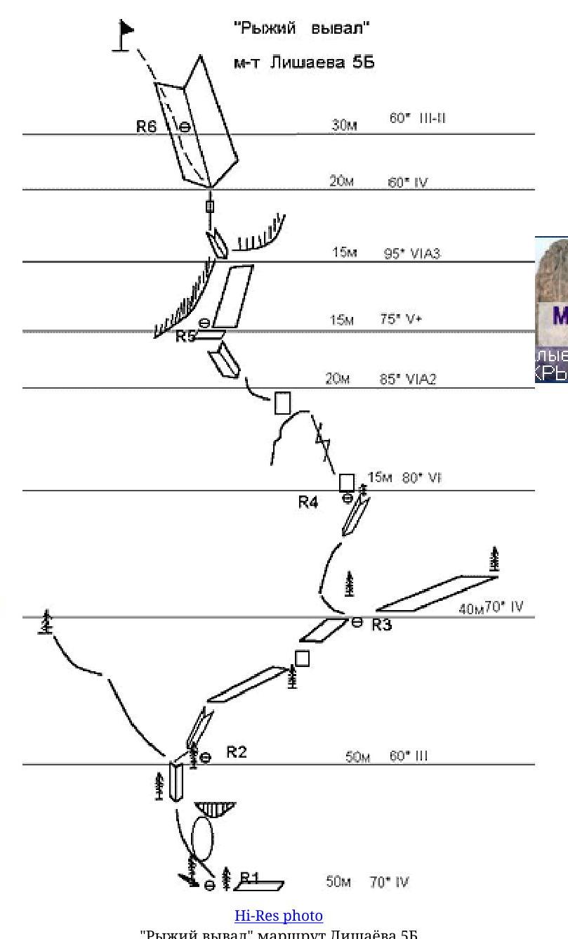
Mshatka-Kaya "Ryzhiy vyval" (55)
Route by Yu. Lishayov ("Fantik"), Crimea
Back to the main page of "Mshatka-Kaya. Three routes"
Author: Alexander Lavriyenko ("Odessit"), Odessa
The route passes to the right of the central bastion of Mshatka-Kaya. It is visited extremely rarely. The beginning coincides with the "Treugolnik sleva" ("Triangle on the left") route.
Having passed along the "Treugolnik" for two ropes (50 m 70IV and 50 m 60III),
"Ryzhiy vyval" — Lishayov's route 5B
move upwards, in the direction of the "red" spot under the cornices.
From the belay point upwards to a small tree. (40 m 70° IV)
Further upwards — left along the crack between the "nashlyopka" and the wall, then along the plate (20 m 80° VI), transition to a small internal corner, and up along it. (20 m 85° VIA2). Belay point on a small ledge.
Further upwards along the plate (10 m 70° V+), then through the overhang (15 m 95° VIA3), exit into a huge internal corner — belay point.
Further up along the left side of the internal corner (20 m 70° IV+), then along simple rocks 30 m 60° II to reach the summit.
Route description by sections
R0–R1 Simple rocks 100 m 50–60° I
R1–R3
- Internal corners
- Walls
- Ledges to the right — upwards
100 m 65° IV–III
R3–R4 Crack, internal corner. 40 m 70° IV (chocks, friends)
R4–R5
- Along the crack 10 m 80° VI
- Then along the wall 5 m 80° VI
- Transition to the internal corner 20 m 85° VIA2 (chocks)
R5–R6 Along the plate 15 m 70° V+, approach under the overhang, passable mainly on pitons 15 m 95° VIA3 (piton placements, chocks)
R6–R7
- Along the left side of the internal corner 20 m 70° IV+
- Then along simple rocks to reach the summit.