Mshatka-Kaya — 9
Along the left edge of the Central Bastion (“Triangulyatsiya”), 4B (35 m, V)
From the upper highway 50 m east of the alpinist camps under Forosky Kant, ascend up and to the right, first along the trail, and then across simple rocks to the left edge of the Central Bastion (R0: 350 m, 30–45, no category).
The sections of the route R1–R5 pass along a wide internal corner situated between the second buttress and the Central Bastion.
Initially, ascend along the right side of the internal corner, and then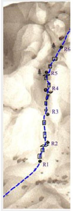
Across steep slabs in its middle part (R1–R3: 70 m, 70°, III+).
On the R3–R4 section:
- First, ascend a 15-meter steep wall,
- Then across a smooth slab into the internal corner.
- Then along it, overcoming a small overhang (R3–R4: 35 m, 80°).
On the R4–R5 section — first 20 m straight up, then up and to the right along a weakly pronounced counterfort (R4–R5: 40 m, 70°, IV+).
The further part of the route goes along the left edge of the Central Bastion. Move up and to the right across rocks of medium difficulty. It ends at the triangulation marker on the summit, clearly visible from below (R5-summit: 120 m, 50–60, II–III).
The ascent takes 3–4 hours. The length of the main part of the route is 265 m.