Mshatka-Kaya — 19
Along the right side of the triangle in the eastern part of the massif ("triangle on the right"), category 3B
Between the Central and Eastern bastions, in the upper part of the wall, two long oblique discontinuous shelves with trees form a large oblique angle, clearly visible from the road, and named the Triangle. The main part of the route passes along the right discontinuous shelf forming the Triangle.
From the upper road, 30 m east of the fork to the lower (main) road and the village of Foros, ascend first along the trail, and then up and to the right along the scree and
simple rocks to a tree- and shrub-covered inclined terrace located under the "Triangle". Along it to the upper right corner (section R0: 250 m, 30–50°, category I)
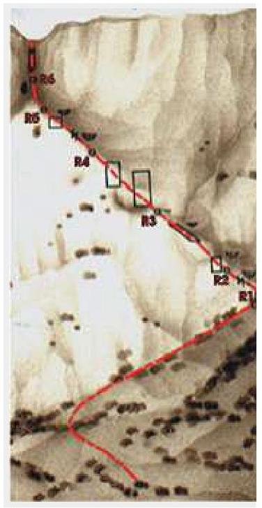
On section R1–R2 — from the right upper corner of the terrace, ascend a 10-meter wall to a long discontinuous groove — the right lateral side of the "Triangle". Along the groove, left and upwards to a large tree (R1–R2: 40 m, 70°, category III)
On section R2–R3 — first up into a small mulde, and then up and left to a shelf at the base of a small internal angle. Along it, left to the external angle (ridge) and then to a small, narrowing shelf (R2–R3: 40 m, 70°, category III).
On section R3–R4 — along complex rocks, left and upwards (R3–R4: 40 m, 80°, category IV+). On section R4–R5 — ascend steep and smooth slabs to the base of an overgrown couloir — the "apex" of the Triangle (R4–R5: 50 m, 70–60°, category III–II).
On section R5–R6 — up the couloir and left to the base of a steep internal angle (R5–R6: 40 m, 60°, category II).
On the final section of the route — up the steep internal angle to the exit onto the summit (R6 — summit: 30 m, 85°, category IV+)
The length of the main part of the route is 240 m. The ascent takes 3–4 hours.
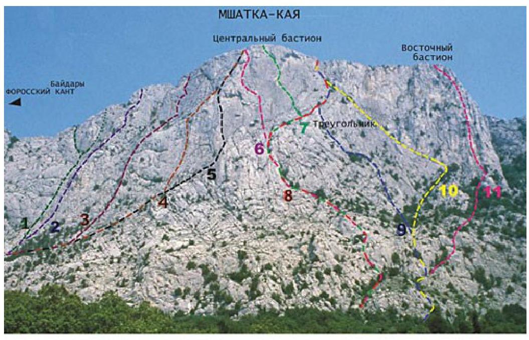
| 1–3А | 2–3Б | 3–4Б | 4–4Б | 5–5А | 6–5Б | 7–5Б | 8–3А | 9–4А | 10–3Б | 11–5А |
|---|---|---|---|---|---|---|---|---|---|---|
| 2004.6 | MOTATOOSH | VVO | Tpeavrymymetpposva |