Merdven-Kayas — 10. “Madera Krymskaya” (380 m, 5B, F6b+, E3, A2) — No bolts.
May 19, 2009
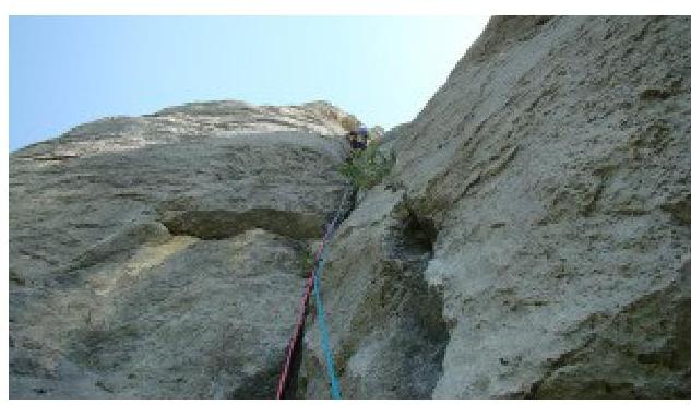
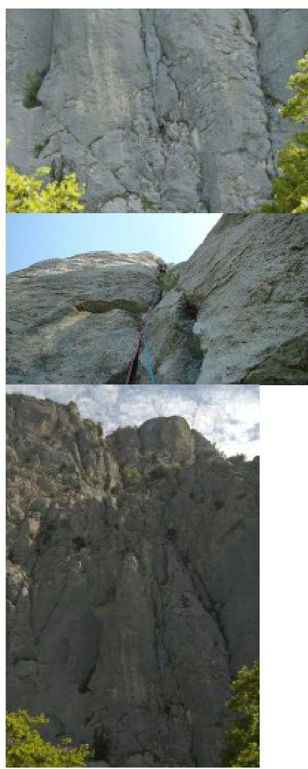
Yura Kruglov is climbing the second rope of the route. The second rope is a song. On Sunday, May 17, we ascended a new line on Merdven-Kayas (10 minutes walk along the upper road to the east from Chertova Lestnitsa). The route is “Madera Krymskaya”.
It was because of this drink that, finding myself among stitched abstainers on Saturday evening and unnoticedly drinking it alone, I had to deviate from the previously planned line of the intended route in its upper part the next day. But even as it turned out, the “Madera” route more than justified my expectations.
Approach to the route, history of the place, descent, and our recommendations
The lower part of Merdven-Kayas wall was a popular training spot for climbers back when the upper road wasn't yet called the upper road. Buses between Sevastopol and Yalta would speed by on it. It's hard to imagine now...
Among climbers, the lower part of the wall was known as “Khergiani rock.” The approach from the upper road to the foot of the wall takes a few minutes. These minutes can be shortened by car via a dirt road branching off the asphalt towards the wall. The road leads to a clearing with a great campsite. From the campsite to the start of the routes, it's less than a minute of slow walking.
Almost the entire lower belt of the rock was used for training and competitions. Restrictions were fixed to the rock with nails. These nails can still be found, crumbling in hands. Competitions for teams were held here, so you can find piton artifacts in the most unexpected places. The belay anchor (at a height of 150 m) was made from a bunch of steel binding wire stretched horizontally for a hundred meters. The wire is still hanging. One of the huge pines, to which the anchor was attached, dried up and fell but remained hanging on this wire at a height of 150 m, reminding of the rock's rich past. This can be seen in detail from the R3 point of the “Madera Krymskaya” route, which is 5 meters to the right.
Given the late start (reasons mentioned above), the rest of the day was spent on the route. We reached the summit at dusk but were very satisfied.
Wishes for climbers:
- There's no water on the route, so bring it with you. We didn't.
- Water can be found in puddles on the descent path in drinkable quantities.
- It's recommended to have headlamps. We didn't, and thus had to navigate by feel along a path we knew well.
- It's also a good idea to have a mobile phone with a charged battery to contact observers who were waiting for us...
Descent path (for those who don't know):
- After completing the route, ascend a hill on the yayla (100 m to the north).
- Then follow the ridge of its summit to the NE towards the forest.
- Descend from the ridge into the forest and immediately hit a forest road leading from Okhotnichy Kolodets with remnants of a house to Chertova Lestnitsa, passing near the summit of Merdven-Kayas.
- Follow the road, always choosing left branches, until you reach a monument to partisans on Chertova Lestnitsa.
- From the monument, descend along the trail to the south (along Chertova Lestnitsa) to the upper road.
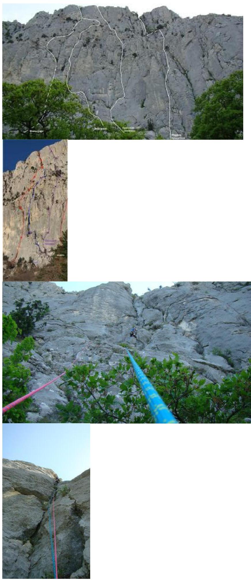
Route Description
The route goes straight up through a vertical crack between huge monolithic “claws” — see photo. The route is logical, and it's impossible to get lost. The difficulty is evenly distributed except for a 60 m section in the middle of the wall.
R0–R1: 40 m up, F5c–F6a+. Difficulty increases gradually. A titanium piton is left on a challenging transition. Belay point is on friends.
R1–R2: 40 m up through a vertical, partially overhanging crack — a great rope! F6b+, A2. In some places, we had to use i.t.o. due to the need to clear the crack of vegetation. Belay point is on a ledge. A duralumin channel is left.
R3–R4: 60 m. Initially, 15 meters of challenging climbing up an overhanging internal corner (partially on i.t.o., a large anchor hook is left) and then 15 m up-right to the end of the corner, followed by easier climbing for 30 meters up to a large tree on the summit of the lower bastion.
R4–R5: From the tree, 10 m on foot along an inclined ledge to the start of the second bastion. Then 60 m up-right (category 2B) towards a large couloir.
R5–R6: 40 m F5a–F5c. Up a vertical crack for 10 m, enter the couloir, and then 30 m up along the right side of the couloir. Belay point is on a tree.
R6–R7: 30 m. Easy climbing up the couloir is significantly complicated by vegetation (!). Exit to a crack — an overhanging grotto that seals the couloir. Belay point is on a ledge at the base of the overhanging grotto.
R7–R8: 50 m. Initially, 15 m up a vertical crack in the left wall of the couloir — to bypass the overhanging grotto (climbing F6b, i.t.o. A2). Then continue climbing on easier rocks and after 35 m reach the yayla.
R2–R3: 50 m. Up the right crack for 30 m, careful climbing F6a+ to a ledge. Then on easier rocks up towards a vertical internal corner to the right of the pine hanging on wire. Belay point is on 2 channels (both left).
A good, long Crimean 5B. If we had climbed the upper part as initially planned, it would have been 6B. We managed without bolts. Standard equipment is necessary. Friends from small to large (Camalot #4), small-medium stoppers are needed. Without anchor hooks, organizing intermediate belay points in some numerous places will become significantly more complicated.

 □
□