Kilse-Burun — 3
Via the second counterfort of the western part of the massif (a question), 3B (IV, 80 m) (V. Chekanov and V. Kozinog's route, 1973)
The approach to the route from the road begins at the end of the long zigzag of the road. From it, the road further goes along the Kilse-Burun massif to the campsite.
On the trail:
- At first, approach a small, separately protruding rock, previously often used for training.
- By going around the rock, move up and to the right along the talus to the base of the second counterfort of the western part of the massif.
An additional landmark can be a large rusty spot on the sheer wall in
the central part of the counterfort. The route passes on the right side of this wall, along a
large and rather complex chimney. It raised so many
questions for the first ascendants that
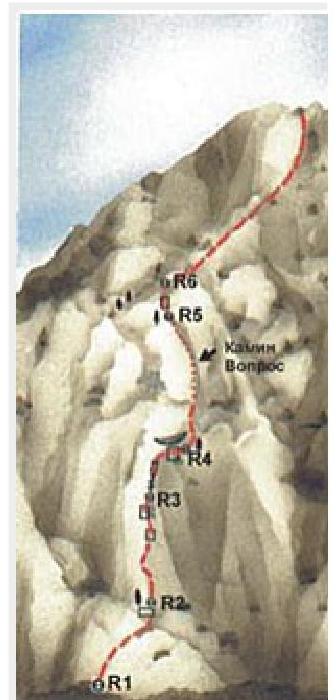
the route received a corresponding name from them (R0: 250 m, 20–30°, category I).
On the section R1–R2 — first 30 m up and to the right along rocks of medium complexity, and then a little to the left to a tree (R1–R2: 40 m, 60°, II).
On the section R2–R3 — first up a steep gap in the direction of a ledge with an overhanging wall. It is bypassed on the right. Further up steep rocks to a tree at the beginning of an internal corner (R2–R3: 40 m, 80°, IV).
On the section R3–R4 — first 30 m up the internal corner under the overhanging wall with a rusty spot in the center. Further, bypassing the wall, up and to the right to a dry tree at the beginning of the chimney (R3–R4: 40 m, 75°, III).
On the section R4–R5 — first up the chimney. In the lower part, it is quite narrow, but it can be bypassed on the right along the wall. After 10 m in the chimney, there is a small, convenient for belaying shelf. From it up and a little to the left. There are practically no places for organizing belays. After 30 m, the steepness of the chimney decreases a bit, it widens and turns into an internal corner. Along it 30 m up and to the left to the exit to the terrace (R4–R5: 40 m, 75°, IV; 30 m, 70°, III).
On the section R5–R6 — 30 m up. Further (section R6–plateau) 100 m up and to the right along simple rocks to the exit to the summit plateau (R5–R6: 30 m, 60°, II; R6–plateau: 100 m, 60°, I). The length of the main part of the route is 320 m. The ascent takes 3–4 hours.