Zamok — 2. Geniush — Shcherbakov Route
Author: Igor Saveliev (SAVA) Foros Dnepropetrovsk
Zamok Route Description "Chapa" ("Chapa" has no relation to Igor Chaplinsky, "sara" means "bolts" in Spanish).
Approach the base of the couloir between the peaks Zamok and Mshatka. Ascend 20m up the couloir, on the right, there's a blue inscription (CHAPA max. 7A+). From the road to the start of the route — 5 min. All protection points are marked in blue. It's very easy to navigate, the route is constantly in view.
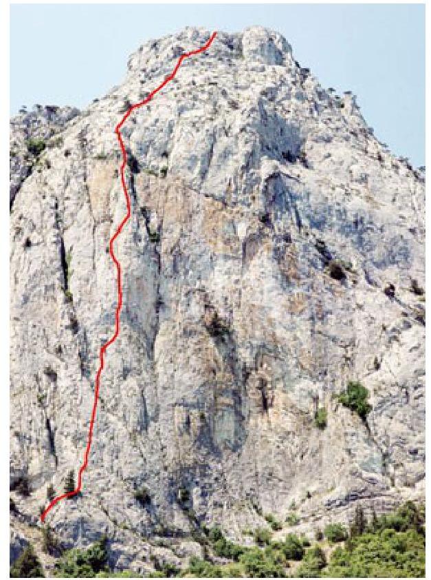
Fig. 1 Route "Chapa" on Zamok peak
The first three pitches have relatively solid rock, further on it gets worse, so be careful and cautious.
Most loose rocks have been cleared. Many areas have been cleaned of grass and soil.
The route was intended to be easier to climb, but it turned out to be more challenging due to the need to anchor to stronger rock. "CHAPA" can be climbed entirely free, but many sections can also be done with artificial aids (ITO), depending on the climbers' skill level. It's recommended to bring various gear:
- profiled sky-hooks
- friends
- pitons
- nuts
A huge request: don't make new holes for sky-hooks, remove your own pitons, and take out your nuts.
It's desirable that the route remains as it was initially created, so it stays interesting and visited by climbers. The route was developed top-down from March 14 to 16, 2003. Later, it was fully climbed free. Big thanks to Alexey Zhilin (Odessa) for a great HILTI drill and Sergey Natodchy (Simferopol) for long and thick
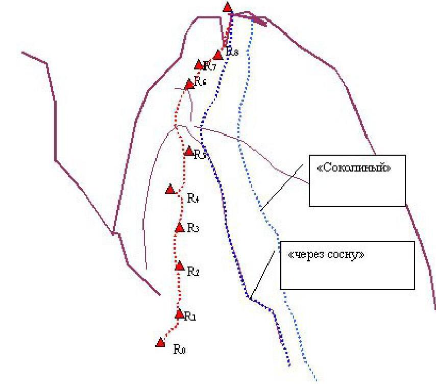
Fig. 2. "Topo" of the "Chapa" route on Zamok peak. (Left part of the central wall along a pronounced bastion, left of the "Through Pine" route) bolted pitons.
- R0–R1 — 3A, 25 m, 1 nut
- R1–R2 — 7A, 35 m, 7 bolts, 1 piton
- R2–R3 — 6A, 30 m, 2 bolts, 2 loops on a tree
- R3–R4 — 7A+, 35 m, 7 bolts
- R4–R5 — 6B, 45 m, 7 bolts, 1 piton
- R5–R6 — 5B, 30 m, 2 bolts, 1 piton
R6–R9
difficulty grade 2–3, move up with a slight deviation to the right, towards a crack in the summit bastion. Up the crack (there's a nut). These three pitches are relatively easy, but it's still recommended to belay (there are trees).
Route length 330 m. The final difficulty grade will be determined after several ascents (as well as the ascent time).