
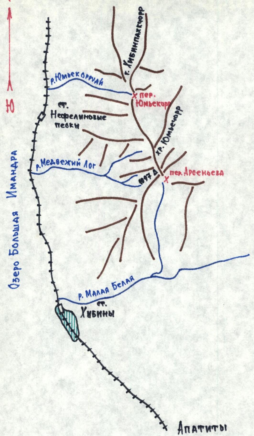
Map of the Yumiechorr Ridge Area. Khibiny Mountains.
Climbing Passport
-
Climbing type — combined.
-
Climbing area — Khibiny Mountains.
-
Peak, its height, and route — via the spur and SW ridge of Yumiechorr ridge. Yumiechorr — 1097 m.
-
Estimated difficulty category — 1B category.
-
Route characteristics: wall height difference —
- I — 1500 m
- II — 100 m
- III —
- IV —
- V —
Average steepness: overall 40°
-
Number of pitons driven:
- for rock protection — 2,
- chocks — ,
- ice screws — .
Including those used for creating artificial support points — .
-
Number of travel hours — from the start of the spur to the summit 3 hours, from Nepheline Sands station to the summit — 5 hours.
-
Full name of the leader, participants, and their qualifications:
- Shumilov Oleg Ivanovich — Master of Sports.
- Proskura Alexander Yakovlevich — 1st sports category.
-
Team coach — Shumilov O.I., Master of Sports, 1st category instructor.
-
Dates: March 28, 1992.
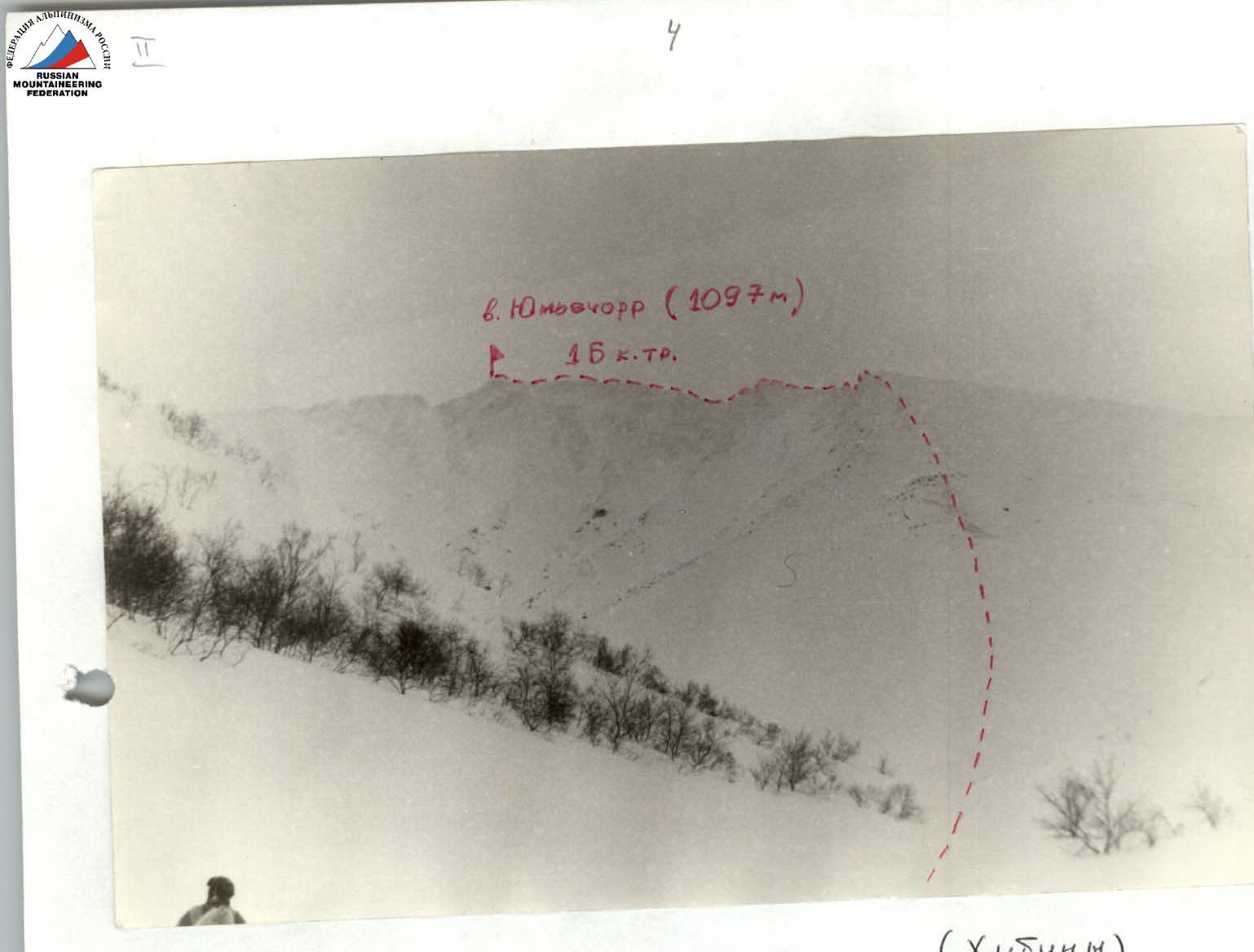
Mt. Yumiechorr (1097 m), 1B category. Southeast ridge of Yumiechorr ridge (Khibiny)
Description of the first ascent route 1B category via the spur and Southwest ridge of Yumiechorr ridge
The approach to the route starts from Nepheline Sands station on the Murmansk railway, where there is a shelter operating 24/7.
Departure from Nepheline Sands station — at 8:45.
Straight along the road, then right (parallel to the railway) to the clearing, along the clearing left to the end of the forest, then right up traverse the spur of Yumiechorr, then descend down, cross the gully, and at an angle of 45° to the gully left, we reach the Medvezhiy Log river — 10:00.
Then straight to the upper reaches of the river, where we approach the spur — leading to the first rise of the Yumiechorr ridge, to the left of Medvezhiy Log pass. The rise of the ridge is significantly higher than the pass. Two spurs form an "L" shape; the ascent is via the right one.
First ascent on March 28, 1992, by:
- Shumilov Oleg Ivanovich — Master of Sports in mountaineering, 1st category instructor-methodologist in mountaineering.
- Proskura Alexander Yakovlevich — 1st sports category in mountaineering, 3rd category instructor-methodologist in mountaineering.
Equipment:
- Main ropes — 140 m, 10 mm — 1 pc; 140 m, 8 mm — 1 pc.
- Ice axes — 2 pcs.
- Crampons — 2 pairs.
- Carabiners — 4 pcs.
- First aid kit — 1 set.
- Down jackets, warm clothing — 2 sets.
- Backpacks — 2 pcs.
- Skis, ski poles — 2 pairs.
- Windproof masks — 2 pcs.
- Ski goggles — 2 pairs.
- Harness, climbing harness — 2 sets.
- Primus stove — 1 pc.
- Thermoses — 2 pcs.
- Fur mittens — 2 pairs.
- Matches, candles.
- Primus stove can — 1 pc.
- Flashlights — 2 pcs.
- Ice screws — 2 pcs.
- Tent — 1 pc.
- Helmets — 2 pcs.
The ascent to the spur — the lower part is traversed on skis — 25–35°. Then a long ridge of the spur — protruding rocks with ice formation. The spur gradually increases in steepness to 35°. Sometimes it's best to traverse in crampons (possible protection via ice axes or ice screws).
In the upper part, the ice formation is covered with snow, the route slightly flattens to 25°. From the start of the spur to the ridge — 600 m ascent. Along the ridge 100–150 m to the left.
Then a descent into a dip — 30 m (traversing with protection) or with the organization of a belay. From the dip along the ridge with "gendarmerie". Crossing the dip, we reach a gendarme composed of loose rock blocks and covered with snow ("Khibiny rime"). Traversing head-on with protection with careful steps and distributing the load on several support points. (Typically, rime does not hold body weight on one leg). Behind the gendarme, a 3 m descent to the ridge.
Further along the ridge, 10 to 2 m wide. We traverse along the center and to the right of the center of the ridge with small ascents to the lowering before the pre-summit ascent. All "gendarmerie" are traversed head-on through the rime, except for the last one, slightly negative, about 3 m high, which is bypassed to the right down a ledge with mandatory thorough protection. Having bypassed the gendarme to the left up to the ridge with cornices to the left. Along the ridge up to the node of Yumiechorr horseshoe. From the first dip to the node 500–600 m. From the node to the left to the summit — 200 m. Reaching the summit of Yumiechorr at 13:45.
Descent from the summit is possible along the ridge, bypassing the summits to the "Stella" and from it to the left along a gentle spur, closing the Yumiechorr horseshoe. A possible descent path — to Arsenev pass, Medvezhiy Log pass, into the Meridialnaya river valley at any point. Vertically down, as the slopes are avalanche-prone.
The weather is good. Descent via Arsenev pass and further into Khibiny. At Khibiny station at 15:50.
Route length — 1 km 600 m. Time taken for the route from the start of the spur to the summit of Yumiechorr (1097 m) — 3 hours.
Total time from Nepheline Sands station to the summit — 5 hours.
Total time (approach, ascent, and descent) — 7 hours 5 minutes.

Ascent Scheme
Ascent scheme using YURA system symbols. O.I. Shumilov's route — 1B category (combined polar). Peak Yumiechorr 1097 m.
- R0–R1 — Spur — 600 m
- R1–R2 — Ridge — 150 m
- R2–R3 — Dip — 30 m
- R3–R4 — Traversing gendarme
- R4–R5 — Descent — 3 m
- R5–R6 — Gendarme — 3 m
- R6–R7 — Ridge from gendarme to node
- R7–R8 — Node
- R8–R9 — Ridge from node to summit — 200 m
Mt. Yumiechorr (1097 m), Mibdendorora.
Comments
Sign in to leave a comment