ASCENT DOCUMENT
-
Ascent class — combined
-
Ascent area — Khibiny Mountains
-
Peak, its height and route — Takhtarvumchorr ridge, via the center of the North face of the East ridge of Takhtarvumchorr ridge, 1143.5 m
-
Estimated difficulty category — 2B category
-
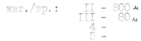
Route characteristics: height difference — 700 m. Walls: Length of sections, difficulty category: II — 800 m, III — 80 m
Average wall steepness: overall 60°
-
Number of travel hours — 4 hours (from the foot)
-
Surname, name, patronymic of the leader, participants and their qualification:
- Shumilov Oleg Ivanovich — leader, Master of Sports
- Proskura Alexander Yakovlevich — participant, 1st sports category
-
Team coach — Shumilov O.I., Master of Sports, 1st category instructor.
-
Dates: January 2, 1992
- Number of pitons for belay: rock — 13, chocks — 1. Including for creating artificial holds — 2.

Takhtarvumchorr ridge, North face, East ridge (Khibiny), 2B category route.
January 2, 1992. Description of the first ascent of the 2B category route (combined, polar). Via the center of the North face of the East ridge of Takhtarvumchorr ridge (or via the crack-chimney). Team members:
- Shumilov O.I.
- Proskura A.Ya.
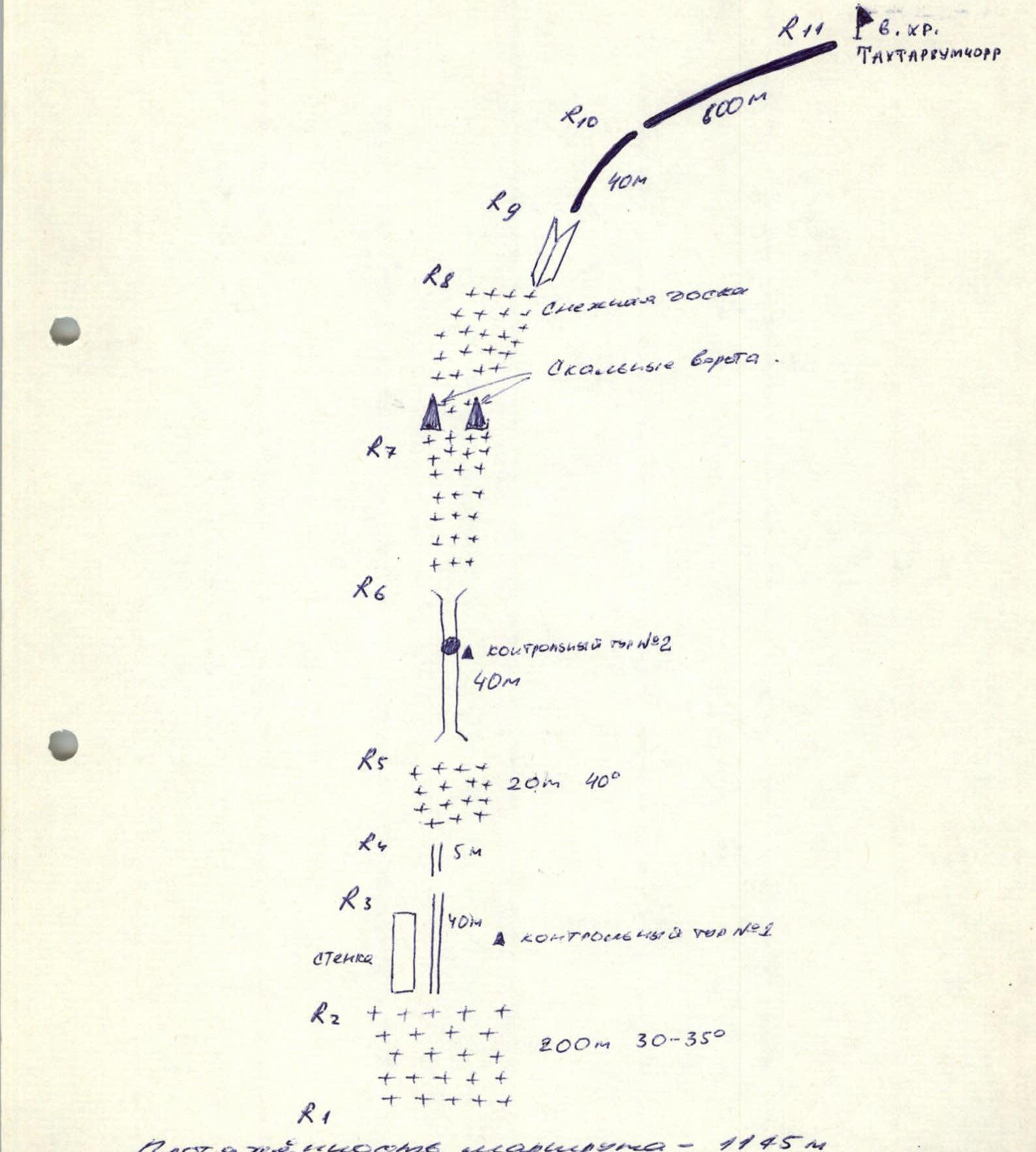
13:00 — 200 m on snow with 30–35° steepness — approach to the vertical crack "chimney". On the right side — control cairn #1. On the left side of the wall, we bypass the chimney (piton belay: 2 pitons) — 40 m, then 5 m up the chimney — in the chimney — 2 pitons, and then 20 m on snow with 40° steepness — exit to the continuation of the chimney (belay via ice axe). Control cairn #2. Chimney — 40 m, in the upper part — a plug, before the plug — control cairn #3. In the chimney — 7 pitons. Then on a snow slab — to the rock gate. The slab gradually levels out. From the top point of the slab to the right — via the inner corner, exit to the ridge — 40 m (2 pitons). Further along the ridge to the right — to the summit. All ascents on the ridge are made in the central part. Closer to the summit, the ridge narrows. Caution — cornices on the right. Descent via 1B towards Geografov pass.
At the summit at 17:00. In Khibiny, unexpected strong winds can occur, which can sweep away from the ridge, so it is necessary to move in a rope team.
Pitons driven — 13. Chocks — 1 piece. Route length — 1145 m. Ascent time — 4 hours.
Equipment:
- Main ropes — 240 m (12 mm and 8 mm Germany)
- Helmets — 2 pieces
- Belay harnesses — 2 pieces
- Rock pitons — 10 pieces
- Chocks — 10 pieces
- Crampons — 2 pairs
- Skis — 2 pairs
- Ski poles — 2 pairs
- Thermos — 2 pieces
- Ice hammer — 1 piece
- Rock hammer — 1 piece
- Ice screws — 2 pieces
- First aid kit — set
- Backpacks — 2 pieces
- Tent — 1 piece
- Stove — 1 piece
- Windproof masks — 2 pieces
- Ski goggles — 2 pieces
- Quickdraws — 5 pieces
- Warm clothing — 2 sets

Materials from Shumilov O.I.
Ascent diagram: combined, polar, 2B category. Via the center of the North face of the East ridge of Takhtarvumchorr ridge (or via the crack-chimney). Ascent diagram with UIAA symbols.
R11 — summit of Takhtarvumchorr ridge R10 — 600 m R9 — 40 m R8 — Snow slab, Rock gate R7 R6 — control cairn #2, 40 m R5 — 20 m, 40° R4 — 5 m R3 — 40 m, control cairn #1, wall R2 — 200 m, 30–35° R1
Route length — 1145 m. Ascent time — 4 hours. Pitons driven — 13. Chocks — 1 piece.


