Ascent Passport
prot. No. 1 dated 10/XI–92, p. 11, p.t., 2A l/s. Znat'iv
I. Ascent class — snow and ice
2. Ascent area — Khibiny Mountains
3. Peak, its height, and route — Mt. M. Vudyavrchorr, via the snow and ice "Avalanche" couloir on the Wall of Mt. M. Vudyavrchorr, 1068.2 m.
4. Expected difficulty category — 2A cat./diff.
5. Route characteristics: height difference — 750 m.
walls
Length of sections, cat. diff.
I — 200
II — 600
III —
4 —
5 —
Average steepness: overall 40°
6. Number of pitons driven:
for rock belay — 4
chocks —
ice screws — 10
Including used for creating artificial holds —
7. Number of climbing hours — 5 hours.
8. Full name of the leader, participants, and their qualifications:
1/ Shumilov Oleg Ivanovich — leader, Master of Sports
2/ Proskura Alexander Yakovlevich — participant, 1st sports category
3/ Serebryakov Yuri Alekseevich — participant, Candidate Master of Sports
9. Team coach — Shumilov O.I., Master of Sports, 1st category instructor
10. Dates: March 22, 1992
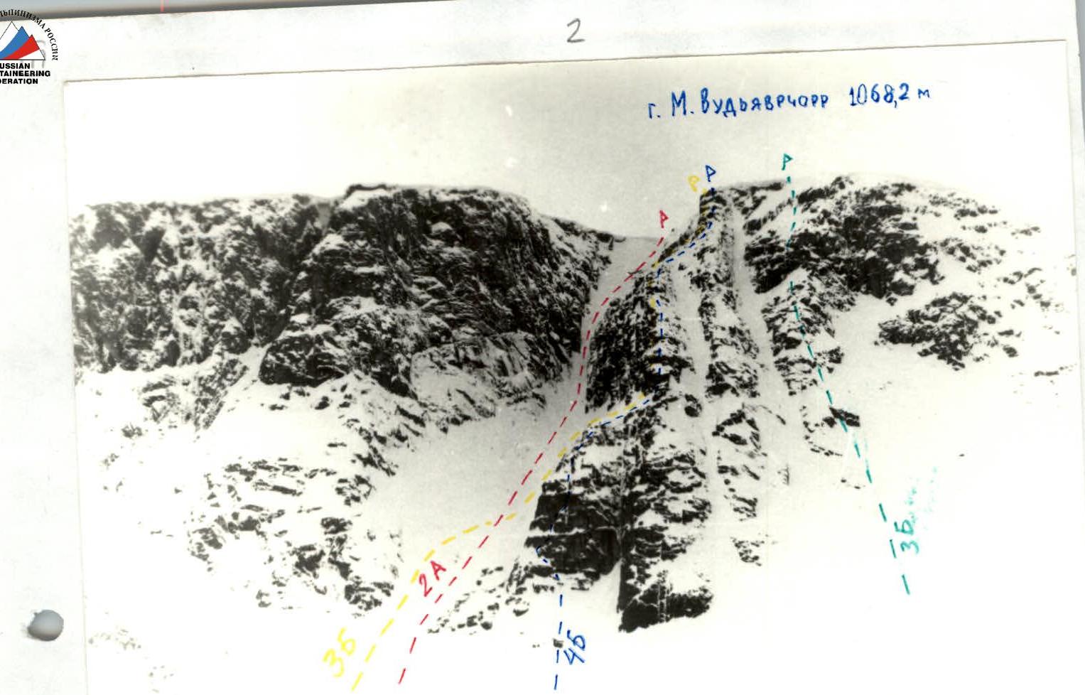
2. M. Vudyavrchorr (Khibiny) route via the avalanche couloir

March 22, 1992. Description of the first ascent of the 2A cat. diff. (combined, polar) route via the snow and ice "Avalanche" couloir on Mt. M. Vudyavrchorr's eastern wall. Second ascent on October 18, 1992.
Team members:
- Shumilov O.I. — Master of Sports, 1st category alpinism instructor.
- Serebryakov Yu.A. — Candidate Master of Sports, 2nd category alpinism instructor.
- Proskura A.Ya. — 1st sports category, 3rd category alpinism instructor. Departed from the 25th km at 7:00. Reached the "Avalanche" couloir by 9:00. 400 m ascent up the "Avalanche" couloir (snow and ice), steepness from 40° to 50°. Belay using ice axes or ice picks. Reached the couloir's narrowing with a steepness of 60° — 200 m, thorough belay (2 ice screws, 4 pitons). Further 150 m ascent — the couloir widens — to the couloir's fork. (On steep ice to the left towards a depression — 60 m, steepness 60°, belay — 5 ice screws, anchor at a ledge). Then on the right side with a steepness of — 65° — 40 m, belay — 3 ice screws. Reached control cairn No.1. Piton with a marker.
11:42. After that, ascended to the right upwards at an angle of 45° (one rope – 30°, on the second – an ice wall – 5–7 m – 70°) and through a narrow couloir with sheer walls exited onto the plateau of Mt. M. Vudyavrchorr. 12:00. Couloir width 3–5 m, steepness – 30°. On the left wall before the exit 3–5 m to the exit, a piton with control cairn No.2.
Drove — 4 rock pitons Ice screws — 10 pcs. Route length — 900 m.
Equipment:
- Main rope — 240 m / 8 mm Germany /
- Expendable cordelette — 5 m
- Ice axes — 3 pcs.
- Ice hammer — 1 pc.
- Rock hammer — 1 pc.
- Rock pitons — 10 pcs.
- Ice screws — 5 pcs.
- Crampons — 3 pairs
- Carabiners — 20 pcs.
- Chocks — 6 pcs.
- First aid kit — 1 set
- Down jackets, warm clothing — 3 sets
- Backpacks — 3 pcs.
- Skis + poles — 3 pairs + 3 pairs
- Windproof masks — 3 pcs.
- Ski goggles — 3 pcs.
- Tent — 1 pc.
- Belay harness — 3 pcs.
- Extension slings — 3 pcs.
- Self-belay slings — 3 pcs.
- Ladders — 3 pcs.
- Stove — 1 pc.
- Fur gloves — 3 pairs
- Matches, candles — 1 set
- Pot — 1 pc.
- Flashlights — 2 pcs.
- Piton puller cord — 1 pc.
- Shovels — 1 pc.
- Thermoses — 3 pcs.
- Helmets — 3 pcs.
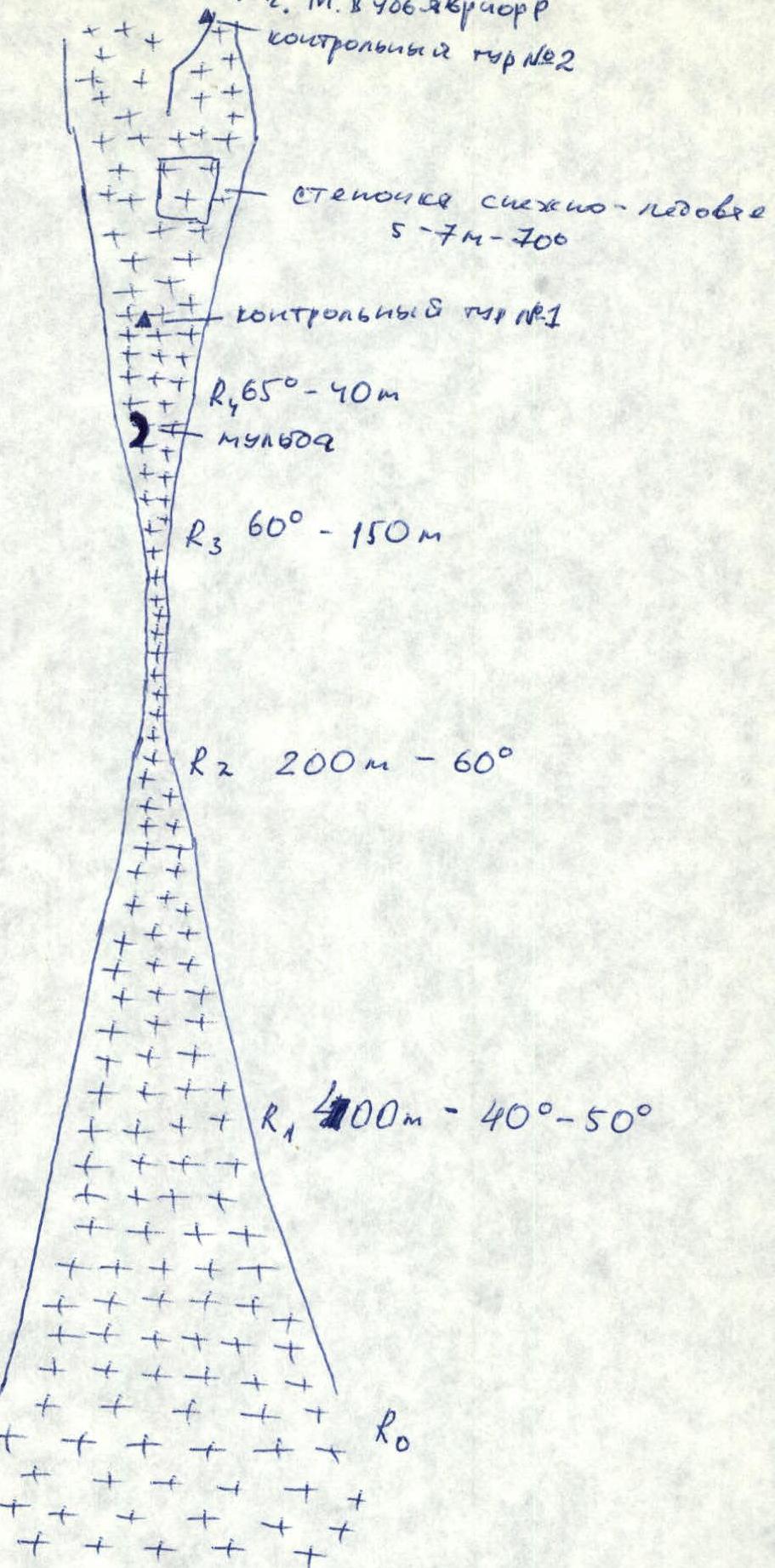
Ascent Diagram
Ascent diagram with MRM symbols.
- M. Vudyavrchorr
- Control cairn No.2
- Ice wall 5–7 m – 70°
- Control cairn No.1
- R4 65° — 40 m
- Depression
- R3 60° — 150 m
- R2 200 m — 60°
- R1 400 m — 40°–50°
- R0