8.4.3
1. Ascent Passport
Region — Northern Urals, 8.4 Peak — Serebryansky Kamen, route "via the right counterfort of the western ridge". Proposed — 2B cat. diff., first ascent.
Route characteristics:
- combined
- winter
Route Characteristics:
elevation gain of the route — 300 m. route length — ~850 m. average steepness of the route — 35°. length of sections with 4 cat. diff. — 15 m, 3 cat. diff. — 70 m.
Left on the route: pitons — 0, protection — 0. Pitons used on the route: rock — 7 protection — 5
Climbing hours — 8, days — 1. Number of bivouacs — 0.
As a Pair
Participants:
Pavlovich Vitaly, CMS. Oleg Victorovich Islamov, 3rd sports category.
Team Coach:
Pavlovich Vitaly, instructor 3rd cat. (certificate №1173)
Departure Date:
ascent start – March 29, 2007 summit – March 29, 2007 return – March 29, 2007
Organization: SDYUSSHOR mountain sports (Yekaterinburg)
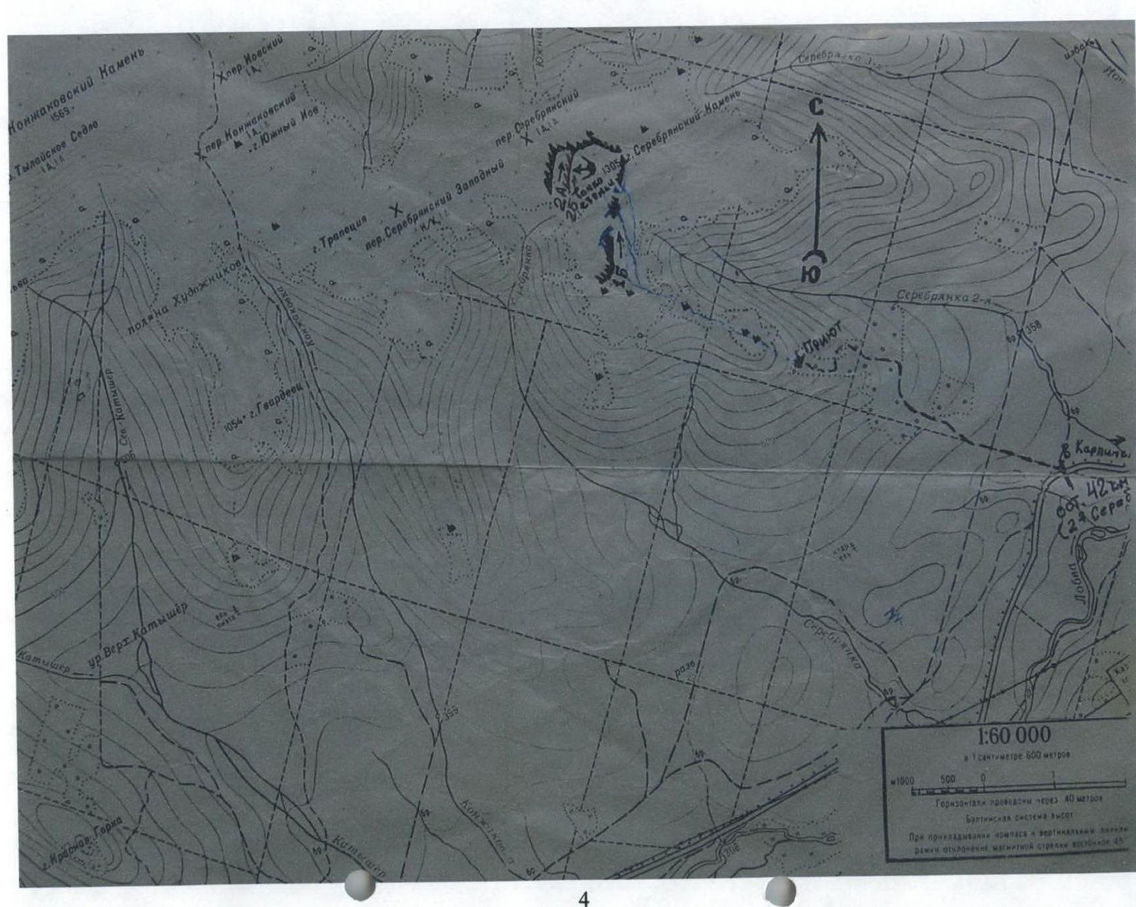
2. Area Map
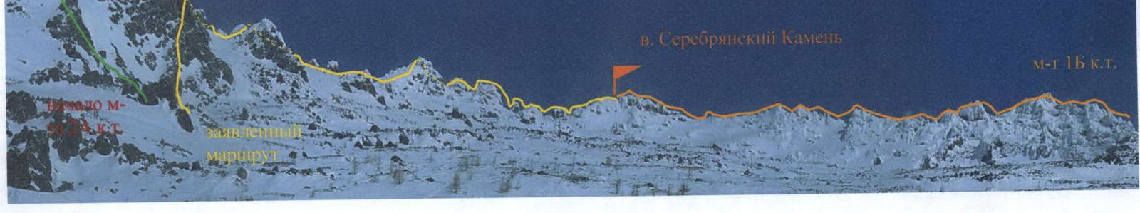
3. General View of the Summit
4. Brief Description of the Area and Ascent
The Serebryansky Kamen area (1305 m) in the Northern Urals is an ideal place for training and ascents to prepare young climbers for the "Alpinist Rossii" badge and 3rd sports category. The relatively close proximity (from Yekaterinburg, it is possible to reach the base camp under Serebryansky Kamen in 17–20 hours), the presence of almost all forms of mountain relief, harsh winter conditions, and a height of about 1500 m are the undeniable advantages of the Northern Urals. These excellent conditions are especially relevant now, when:
- access to high-altitude areas is limited,
- financial considerations are also important for students and senior schoolchildren when traveling to the mountains.
Thus, the presence of classified routes with 2B cat. diff. in this area would be a good stimulus for further mountaineering development and would attract many young people to climbing.
There are currently two classified routes to the summit of Serebryansky Kamen: 1B cat. diff. via the southern ridge (Kovrizhkin A.V.) and 2A cat. diff. via the southern spur of the western ridge (Zemerov V.I.). The routes are combined, with predominantly rocky sections covered in snow, and sections of firn and snow.
Subzero temperatures and very strong winds significantly complicate the application of technical techniques for movement and belaying. Often, ascents take place in conditions of poor visibility due to snowstorms and low cloud cover. There are no stationary bases or shelters under Serebryansky Kamen, so base camps are usually set up in the forest zone, in tent camps. Approaches to the routes are made on skis, as there is often a lot of snow in this area in winter.
The proposed route for classification begins approximately 100 m to the right of the starting point of the 2A cat. diff. route, from a rocky mini-counterfort that goes up to the right under the right part of the shovel-shaped rocky wall, which is clearly visible when approaching. The height of the wall is estimated to be 60–70 m. After passing the mini-counterfort, the route goes up the right part of the wall via an internal corner; the last 10 m of climbing are difficult and require piton belays or the use of protection. This is the key section of the route. After reaching the top of the wall, the route follows a snowy slope in the direction of a two-peaked rocky tower, which is traversed in the center; then, again along a snowy slope, it reaches the highest rocky pyramid on the western ridge of Serebryansky Kamen.
The pyramid is overcome:
- "head-on"
- or via the right, steepest wall (40 m) — with alternating belays.
Descent:
- sport descent, 20 m to the northern slope of the ridge;
- then back onto the ridge in a depression.
The route then follows the western, heavily serrated rocky ridge all the way to the summit.
Descent:
- the first few dozen meters follow the ascent route;
- then left onto the southern slope;
- via talus — into the Serebryanka River valley.
The sufficiently difficult climbing and belaying on the first section of the route (rocky wall), as well as the passage of the pyramid, suggest a category difficulty of at least 2B.
5. Route Description by Sections
The approach to the route from the base camp in the valley of the 2nd Serebryanka River usually takes 1–1.5 hours. Skis are left 200–300 m below the forest boundary.
From the forest boundary:
- 300–400 m are traveled via talus in the direction of the summit of Serebryansky Kamen;
- then gradually up to the left onto the southern slope of the western ridge;
- another 300–400 m in this direction;
- and it is already possible to clearly see the characteristic shovel-shaped rock that crowns a small cirque, bounded on the left by a spur along which the 2A cat. diff. route passes, and on the right — by a mini-counterfort, where the ascent begins.
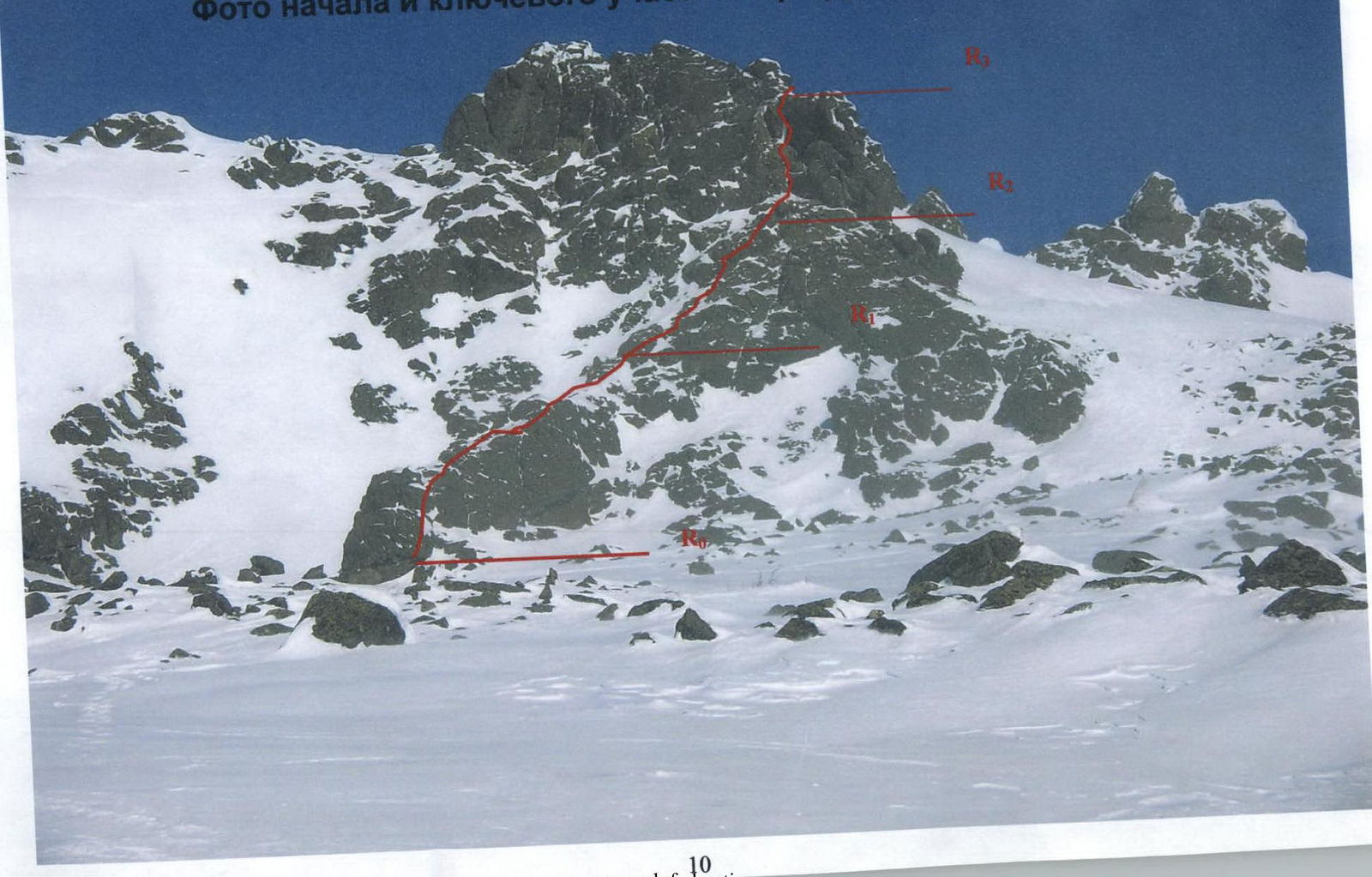
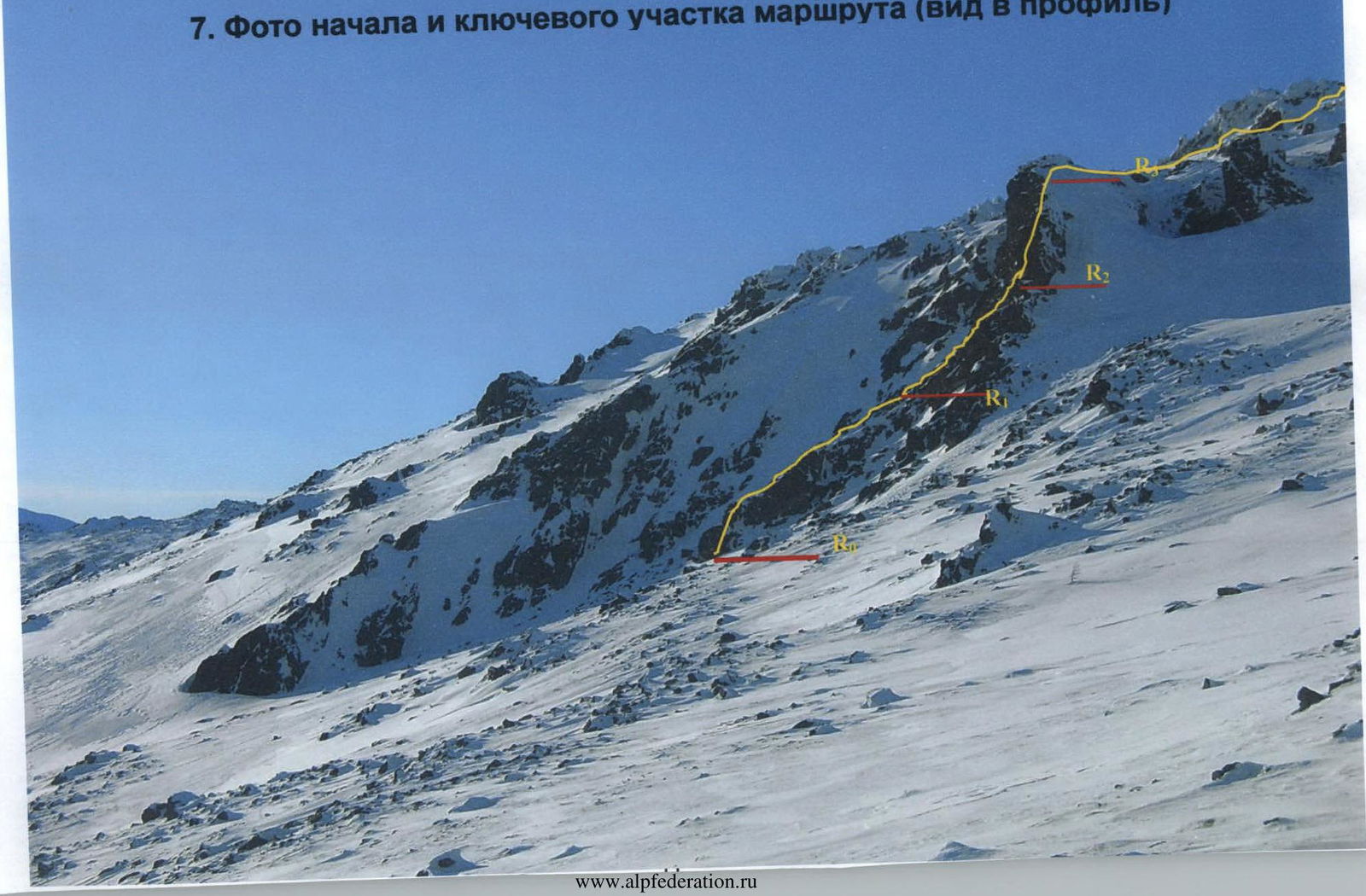
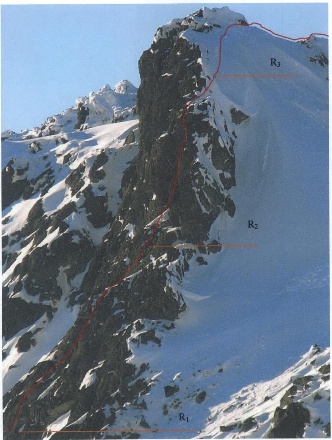
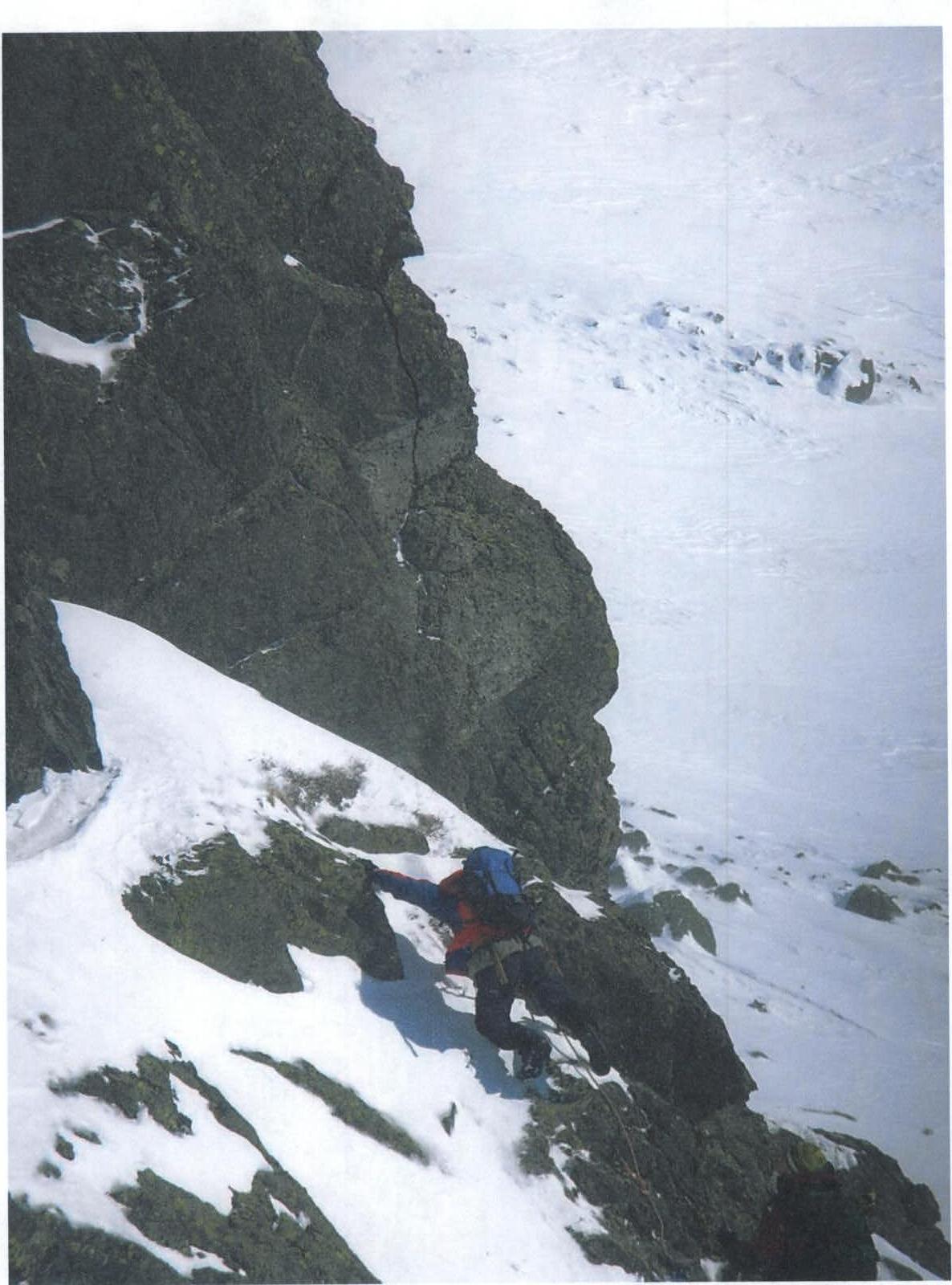
Section R0–R1. 5 m of moderate-difficulty rock climbing, and exit onto the crest of the counterfort, then along it. Movement is done on foot, with hand support for balance. To the right — drop-offs, belay via rock outcrops. Thus, along snowy rocks for 30 m — exit onto a narrow saddle with a characteristic jammed rock on it. Here, it is possible to organize a station using pitons or protection.
Section R1–R2. After 7 m, the counterfort transitions into a wall, the steepness increases to 50–60°, here it is necessary to organize intermediate belay points — 2–3 points. This section is climbed with piton belays, as the rocks are snowy and sloping, without clear large holds. Along the wall, ~10 m of moderate-difficulty climbing in the direction of a characteristic snowy horizontal ledge with cedar bushes under the snow. 2–3 m before the ledge, it is convenient to organize a station, as there are good cracks for pitons. Here, a titanium wedge and 2 combination hooks were hammered in. The length of the section is ~24 m.
Section R2–R3. Then, a 3 m exit onto the ledge via sloping, snowy rocks without large holds. Above the ledge, a vertical internal corner rises to a height of 7–8 m. Climbing logically proceeds along the left side of the corner. This is the key section of the route. Climbing is ~6B cat. diff. Directly from the ledge, it is possible to hammer in a combination hook into an inclined crack on the left wall of the internal corner. There is nothing substantial for the feet — one has to pull up on the hands, on small holds, to place the left foot on a more or less good hold.
Climbing involves:
- Approximately 2 m of climbing on small holds;
- Intermediate belay point using 2 paired stoppers in a vertical crack;
- On the wall — a rhomb-shaped rock, one needs to step onto it with their feet onto a small ledge under 1/2 foot;
- The internal corner ends at the top with a cornice, and one needs to exit the corner to the left — onto the wall;
- Before exiting, it is desirable to make another intermediate belay point using 2 small stoppers, placing them in a crack in the internal corner and using a long quickdraw to reduce friction when exiting left from the internal corner;
- Exit from the corner is made via a characteristic small "horn" (10 cm) — a protrusion, which is located at chest level, exit is strenuous, as there are no good large holds for the feet. The structure of the rocks is very interesting — conglomerate of black and gray crystals.
- After reaching the "horn" (protrusion) — traverse ~2 m to the left;
- The rock becomes more stepped, but more broken (careful — "live" rocks!);
- 3–4 m of careful climbing and exit onto the top of the wall.
Slightly descending from the rocks onto the snow, it is convenient to organize a station with belay via a rock outcrop and waist or via a protrusion. The steepness of the upper part of the wall is 80–85°. In total, 7 pitons were hammered in, 3 stoppers and 2 hexes were placed. Time to pass the wall is ~2 hours.
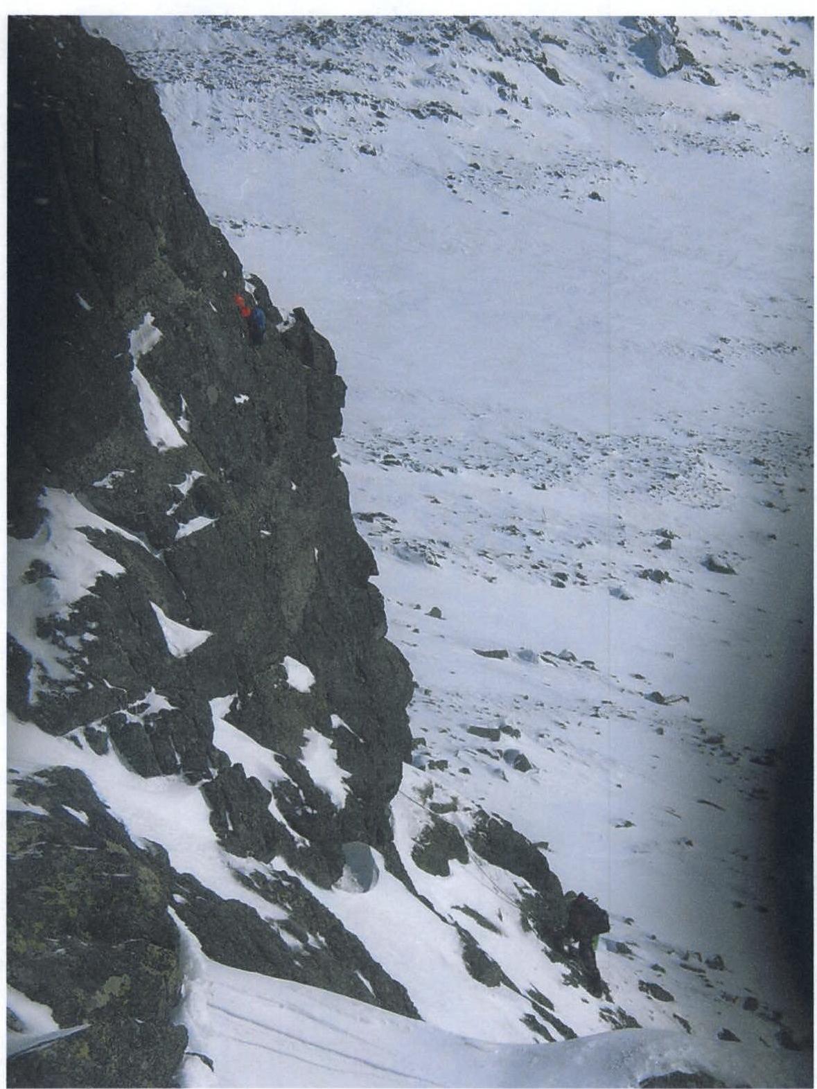
Section R3–R4. Then, 40 m along the snow along the crest of the wall and exit onto a snowy slope, 100 m along it in the direction of a two-peaked pinnacle, which is traversed simultaneously in the center between the towers. Descent to the other side of the pinnacle via firn ~30 m.
Section R4–R5. Then, also approximately 100 m along the snowy slope, approach under the southern wall of the highest tower — the pyramid on the western ridge of Serebryansky Kamen. The route assumes passage of this wall with exit onto the summit of the central tower. The steepness of the wall is 50–60°, the length is about 40 m, the ascent can be made either on the right or left part of the wall. The rocks are sloping, snowy, pitons go in poorly. Descent from the tower — to the other side of the ridge ~20 m via rappel or sport descent via a protrusion.
Section R5–R6. Exit onto the ridge, and then the route follows the ridge (200 m) all the way to the summit, simultaneously or with alternating belays.
6. Photo of the Start and Key Section of the Route (frontal view)
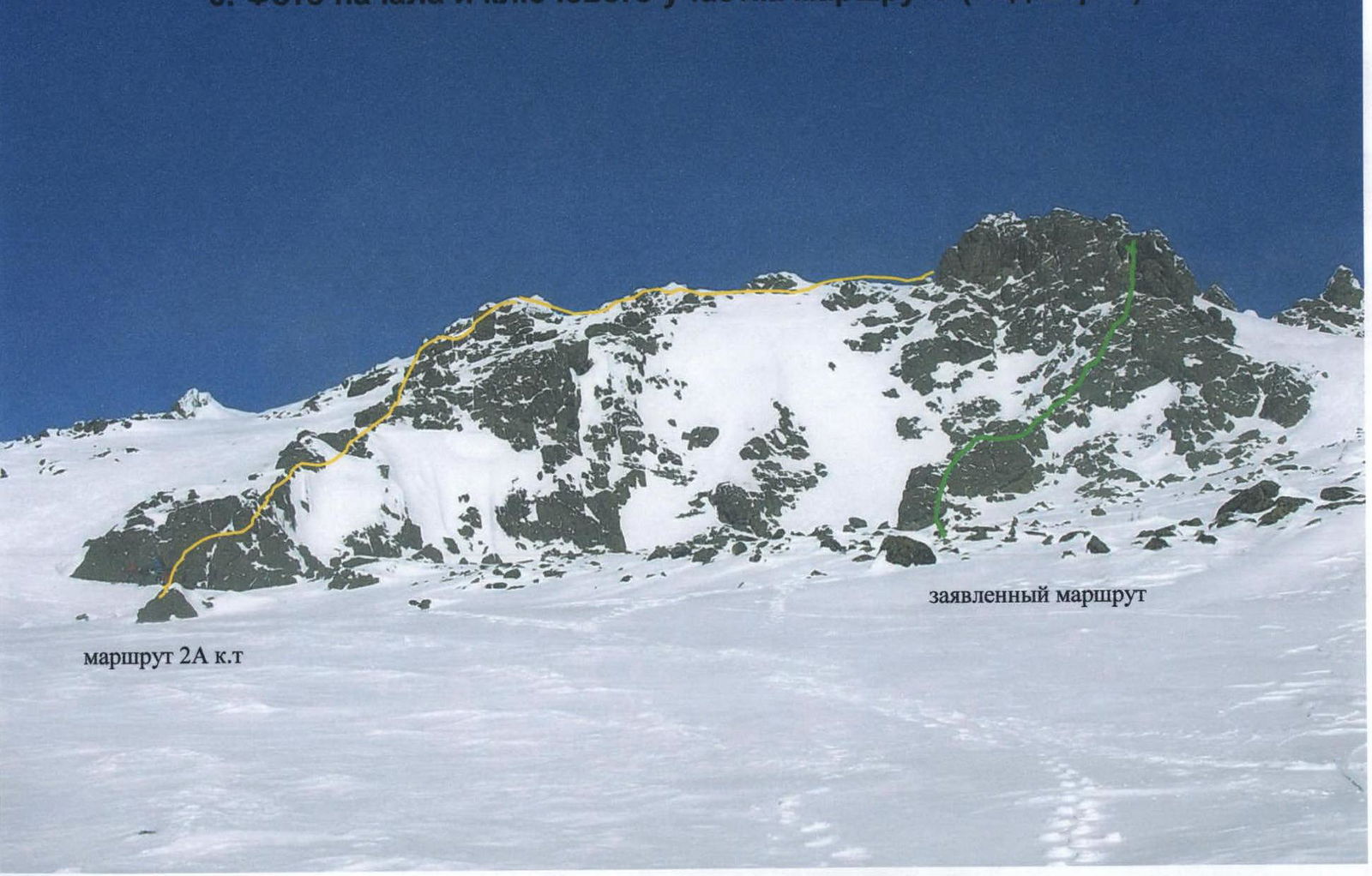
Photo of the Start and Key Section of the Route (frontal view, enlarged)
7. Photo of the Start and Key Section of the Route (profile view)
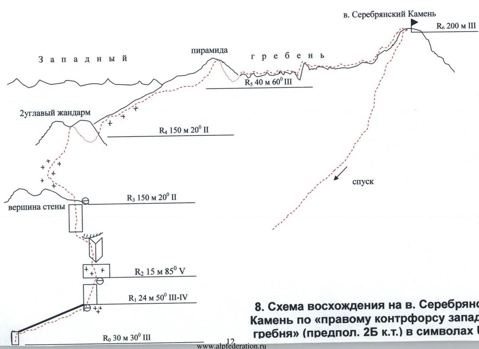
8. Ascent Diagram to Serebryansky Kamen via the "right counterfort of the western ridge" (proposed 2B cat. diff.) in UIAA symbols
9. Photo of the Profile of the Key Section of the Route
10. UIAA Diagram of the Key Section of the Route
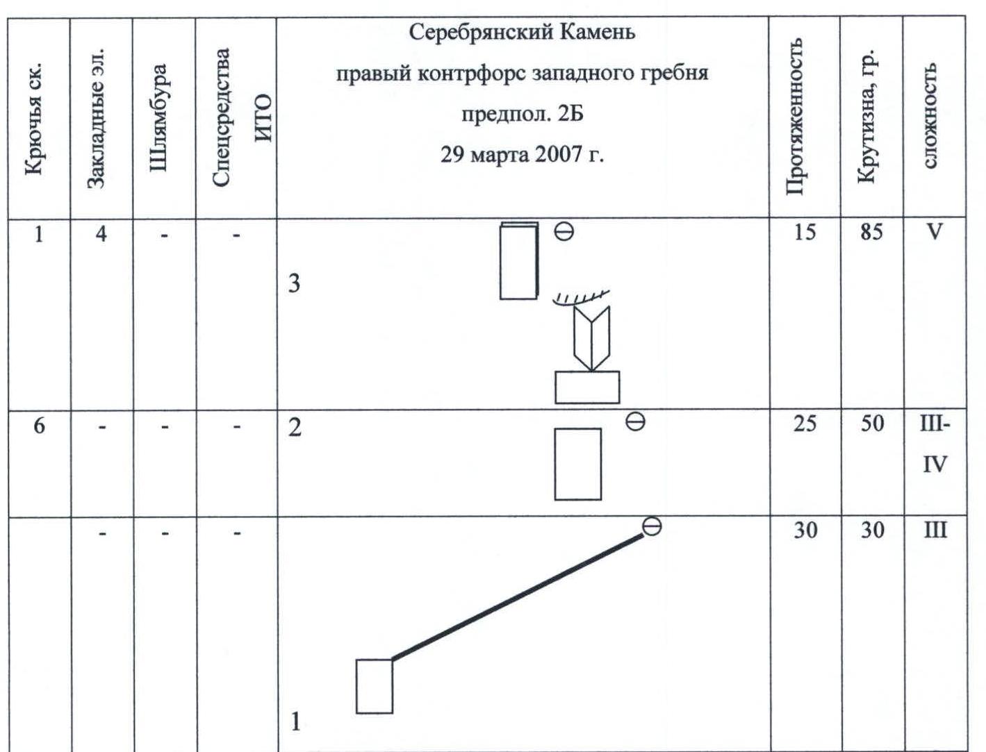
Exit from the 2nd station
Key wall. At the exit from the internal corner