
Passport
- Section number according to KMGV — 2010 — 8.3. 65
Polar Urals, Raiiz mountain massif, Enga-Yu river valley
- Name of the peak: 1036.0 (Chernyaya Tsentralnaya)
height: 1036.0 route: via the north-eastern ridge.
- Category of difficulty: 2A, pp
- Character of the route — combined.
- Height difference of the route: 640 m
- Length: 3500 m
- Length of sections with the highest category of difficulty:
R1–R2 — 600 m, R2–R4 — 2900 m, R3 — 0 m, R4 — 0 m, R5 — 0 m, R6 —
0 m.
- Average steepness: main part of the route — 60 degrees.
entire route — 45 degrees.
9. Pitons used:
Total pitons used on the route:
- rock pitons — 0
- chocks — 4
- stationary pitons — 0
- ITO — 0
- removable pitons — 0
Pitons left on the route: total — 0; including pitons — 0.
- Departure for the route — 7:00, November 2, 2010
Reached the summit — 15:30, November 2, 2010. Returned to BL — 19:00, November 2, 2010
- Team's walking hours: 12 hours.
- Leader: Maltsev Sergey Leonidovich, 1st sports category, instructor 2nd category
Participants: G. Nosova (Ukhta, 2nd sports category), A. Goletarov (Inta, 3rd sports category), A. Bonchuk (Syktyvkar, 2nd sports category)
- Coach: Zhuravlev Sergey Vasilyevich, title — CMS, instructor-methodologist 1st category.
Description of the peak
The peak Chernyaya (Tsentralnaya) is one of the peaks in the Raiiz mountain massif, located in the Yamalo-Nenets Autonomous Okrug (YNAO) of the Tyumen Oblast, Ural Federal District of the Russian Federation, on the eastern slopes of the Polar Urals, 50 km southeast of the settlement of Kharp, in the valley of the Enga-Yu river (right-bank tributary of the Sob river), is the highest peak of the Chernyaya mountain. The peak is dome-shaped, height — 1046.0 m.
The peak Chernyaya (Tsentralnaya) can be an object for training and sports ascents, as it has:
- a number of pronounced rocky ridges on the northern slope,
- rocky carling ribs on the northeastern cirque of the northern slope,
- rocky carling ribs on the northwestern cirque of the northern slope.
The name of the mountain is official, it is on the maps of the Polar Urals, orographic clarifications of the peaks (Eastern, Central, etc.) are given for the convenience of orientation for alpinists.
Description of the route: "via the north-eastern ridge".
Route: "Via the north-eastern ridge 2A category of difficulty (combined)" — a characteristic training route of the second category of difficulty, with a full set of natural obstacles corresponding to routes of this level of difficulty.
Passing this route has not only aesthetic but also sports-practical significance, as it allows to work out belaying and self-belaying techniques on rocky and snowy-icy terrain within the ascent.
The route is ridge-like, objectively safe, which allows for training and sports ascents in the winter period.
Equipment
For an ascent as part of a training and sports group of 6 people (5 participants + instructor) on the route, the following special equipment is necessary:
Personal:
- Standard issue
- Crampons
- Ice axe (mandatory)
Group:
- Main rope 10 mm — 3×50 m
- Rock hammer — 1 pc.
- Rock pitons — 6 pcs.
- Ice axe — 1 pc.
- Chocks — 6 pcs.
- Ice screws — 3 pcs.
- Quickdraws — 6 pcs.
- Slings — 8 pcs.
Approach
From the base camp — "Balok dorozhnikov" near the road leading from Kharp to the mine, cross the Enga-Yu river (4 km — 1.5 hours), then enter the canyon of the cirque.
At the beginning of the canyon, there is a convenient place for organizing rope teams.
Technical part
From the canyon, ascend the snowy-scree slope to the base of the rocky ridge. Then, along the heavily serrated ridge, ascend to the "Plity" section. The section requires knowledge and skills in organizing intermediate belay points.
The section is not difficult, but is located on a narrow ridge and requires participants to pass a series of smooth slabs with passive holds carefully and safely.
The key to the route is the narrow ridge between the slabs — "Nozh". "Nozh" is not only technically and psychologically challenging but also subjectively dangerous. During periods of heavy snowfall, a snow cornice forms on the ridge.
After the ridge:
- ascent along the slabs;
- exit to the pre-summit ridge;
- movement along the ridge to a smooth slab;
- overcoming the slab by climbing;
- exit to the second rocky shoulder.
The ridge becomes easier, then gets lost in the large-block scree of the summit dome. The summit dome is snow-covered in winter and requires three-pace movement.
Descent from the summit
Via the ascent route.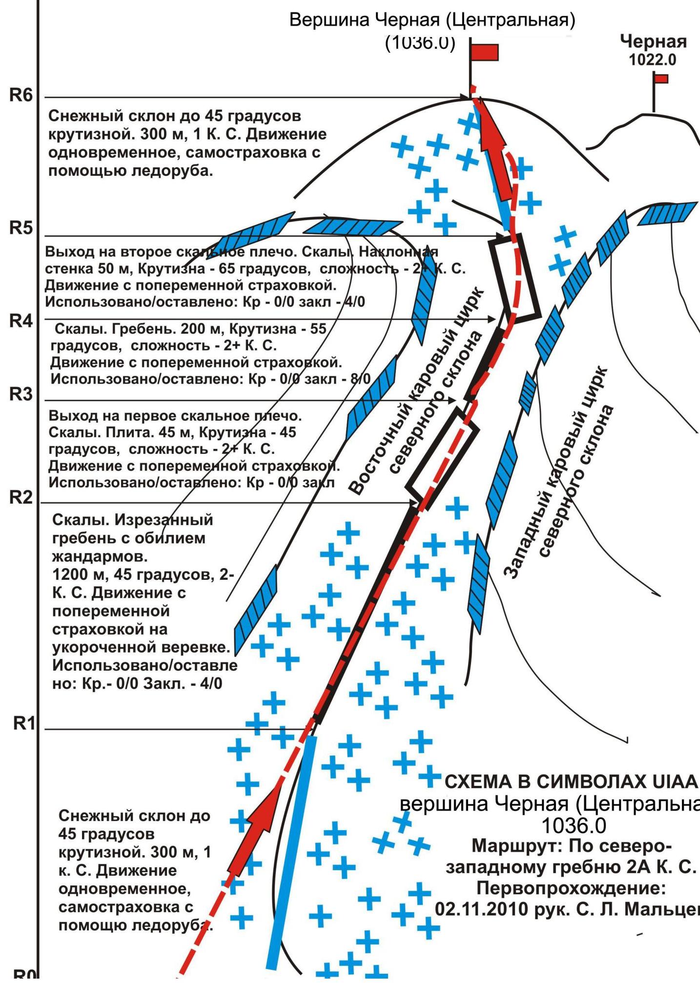
Snowy slope up to 45° steepness. 300 m, 1 km. Simultaneous movement,
self-belaying with an ice axe.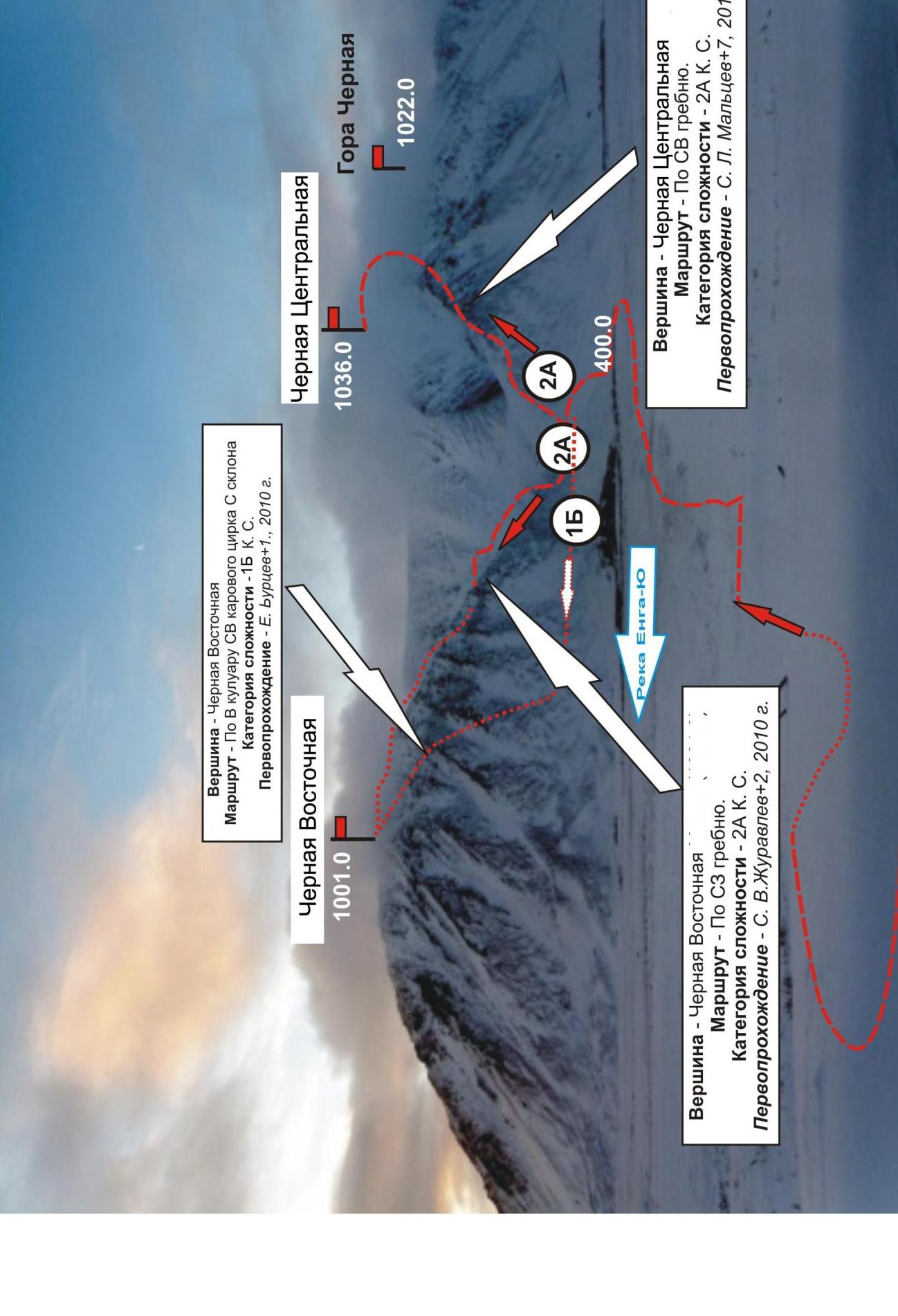
1001.0
Chyornaya Tsentralnaya
1035.0
Gora Chyornaya
1022.0
Peak — Chyornaya Vostochnaya
Route — via NW ridge. Category of difficulty — 2A km. Repeat ascent — S. V. Zhuravlev+2,
2010
year.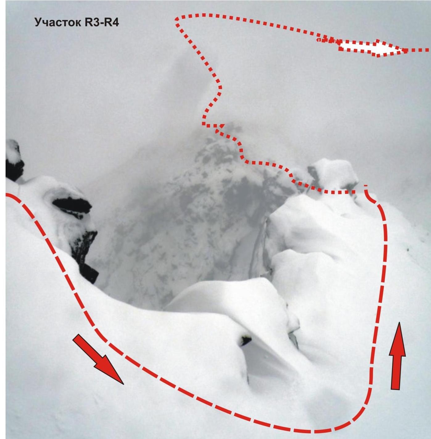
Key to the route — rocky ridge
"Nozh"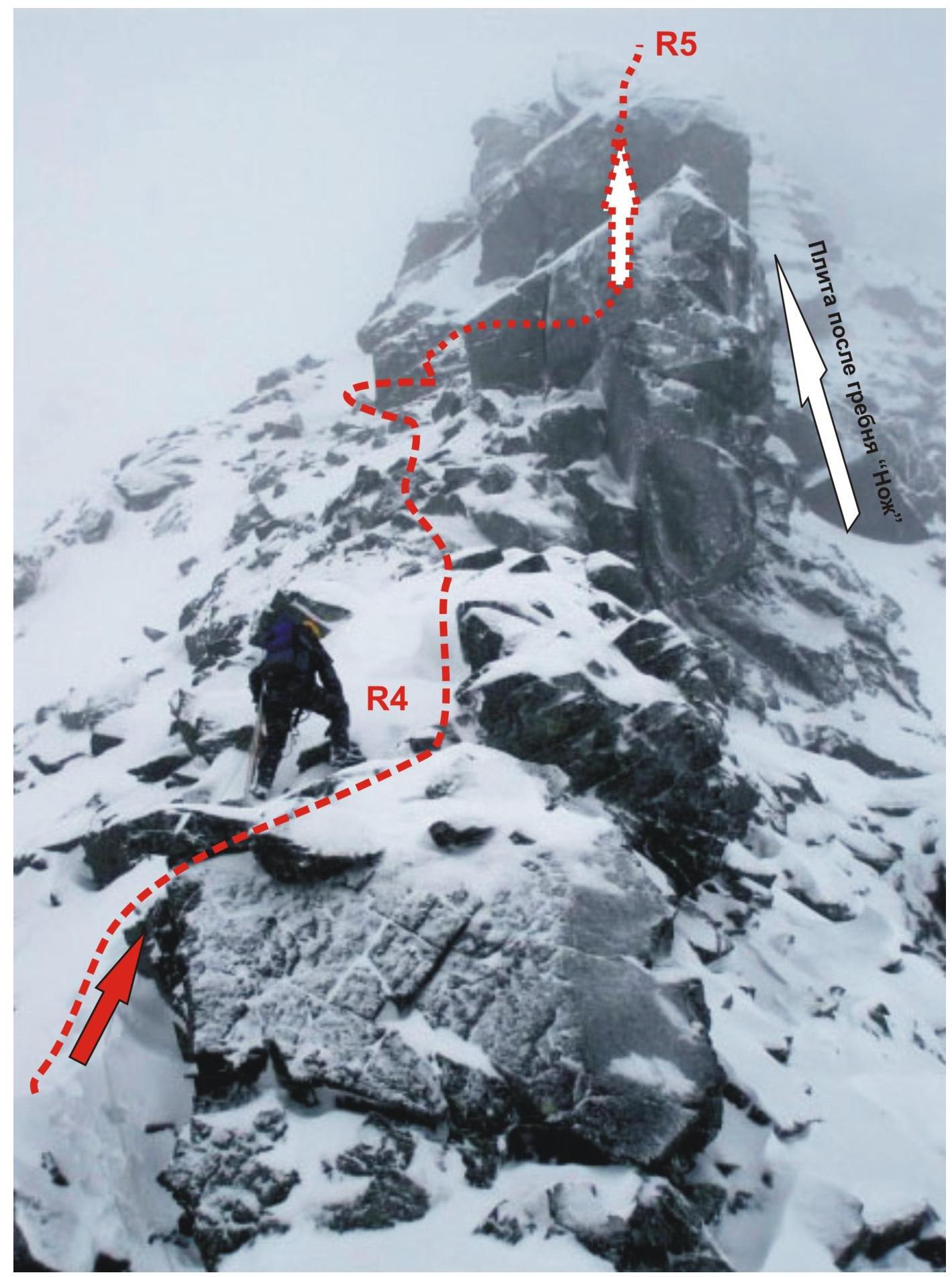 □
□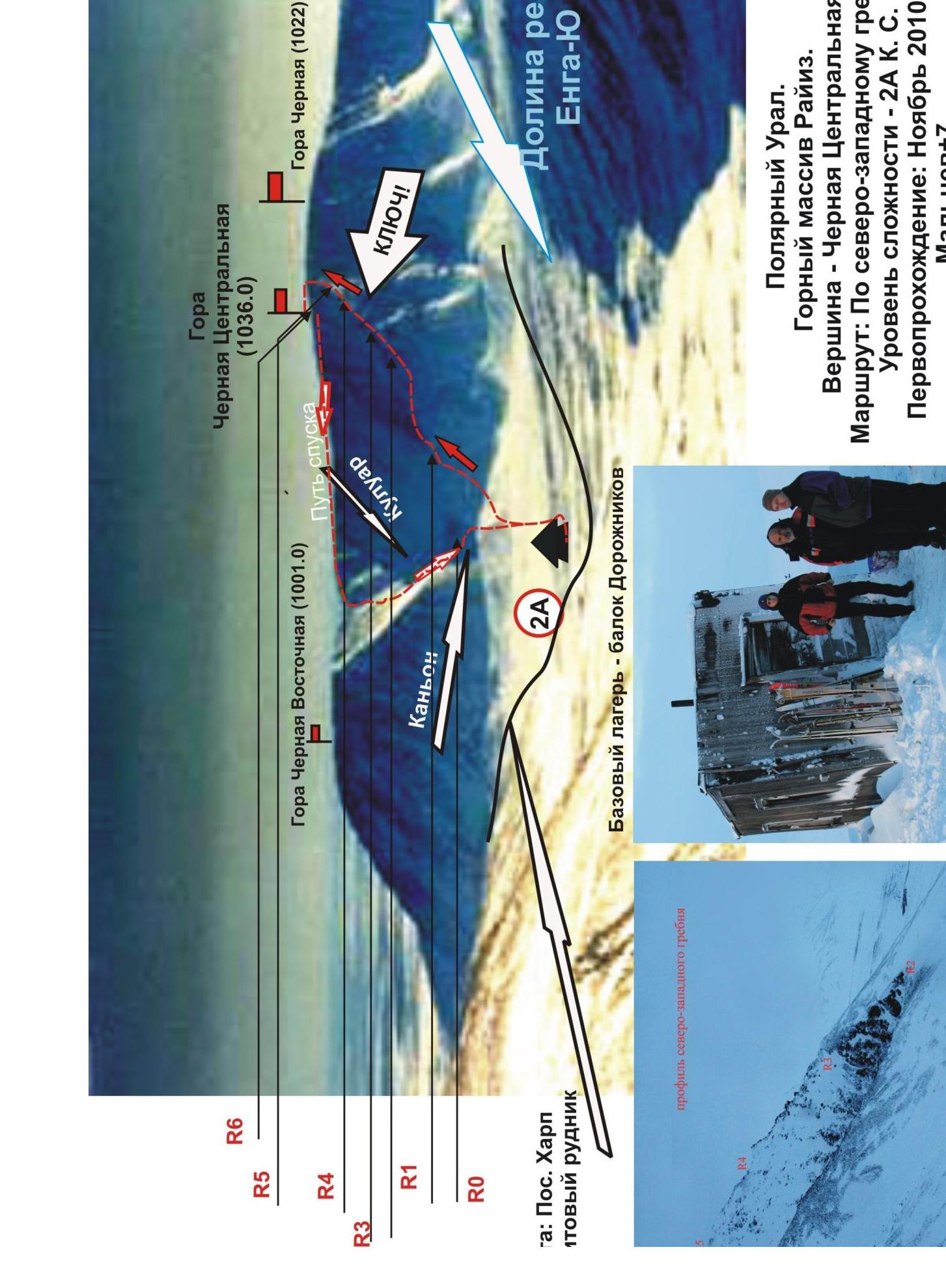
Polar Urals. Raiiz mountain massif. Peak — Chernyaya Tsentralnaya. Route: via the
northwestern ridge. Level of difficulty — 2A category. First ascent:
November 2010, S. Maltsev+7. Photo from the northwest, from the slope of the mountain
Enga-yu-Iz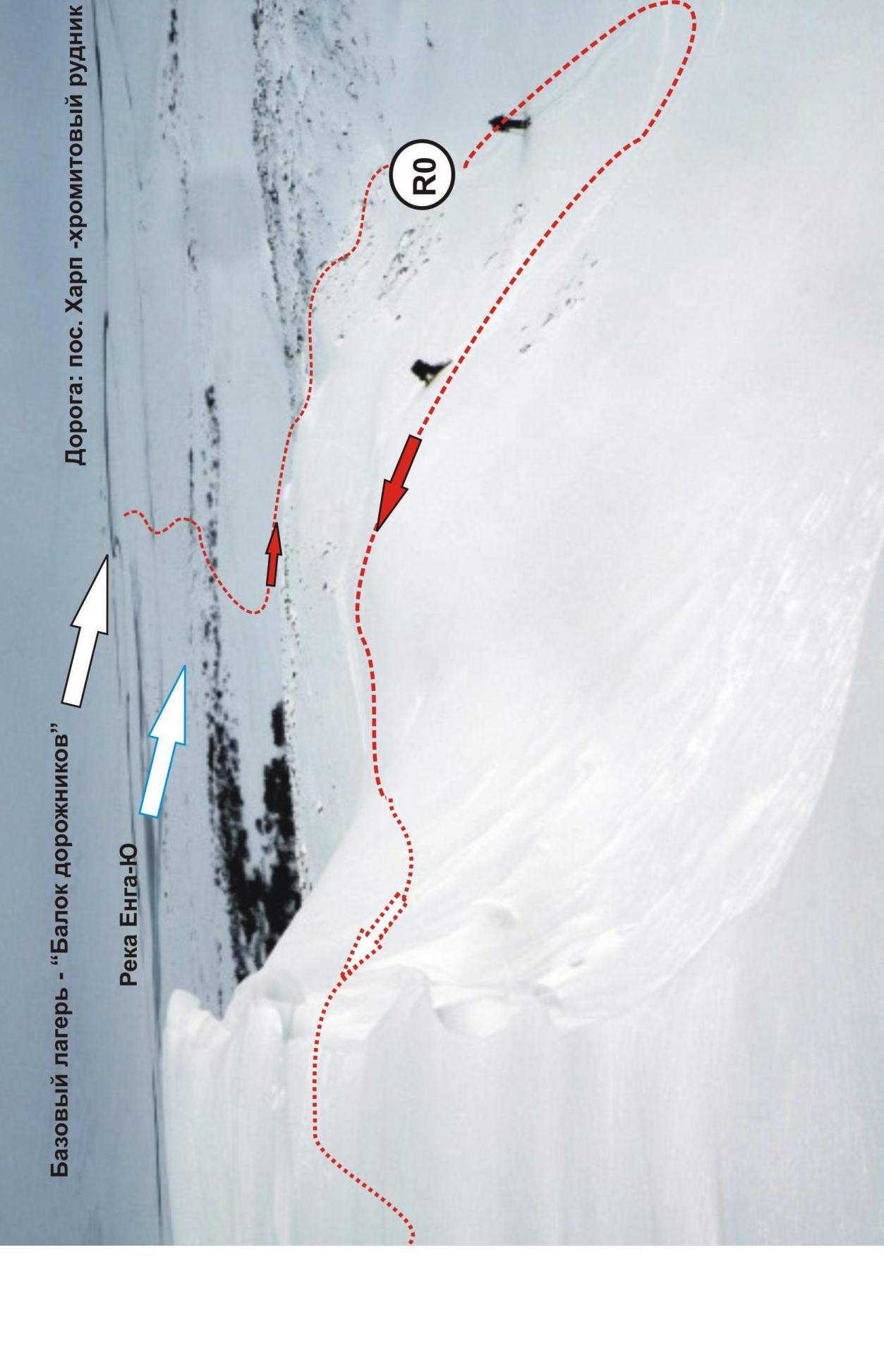
Comments
Sign in to leave a comment