
Ascent Passport
- Region, valley, section number according to KMGV
1.1. Region — Приполярный Урал (Subpolar Urals). 1.2. Ridge — Исследовательский кряж (Research Ridge). 1.3. Valley — Долина реки Балбанъю (Balban'yu River Valley). 1.4. Section number according to KMGV-2001 — 8. "Other mountain systems, massifs".
- Name of the peak, height, route name
2.1. Name of the peak — Старуха (Starukha). 2.2. Height — 1328 m. 2.3. Route name — по северо-восточному гребню (via the northeast ridge).
- Proposed category of difficulty for the ascent (variant, combination) for the first ascent
3.1. Proposed category — 2A.
- Character of the route
4.1. Rock.
- Height difference, route length, length of sections with 5th category of difficulty, 6th category of difficulty. Average steepness of the main part of the route, entire route
5.1. Height difference — 800 m. 5.2. Route length — 1500 m. 5.3. No sections of 5th category of difficulty, no 6th category of difficulty. 5.4. Average steepness of the main (technical part) of the route — 60°. 5.5. Average steepness of the entire route — 45°.
- Pitons left on the route, including bolted pitons, used on the route: rock pitons, chocks, bolted stationary pitons, bolted removable pitons, ITDs
6.1. No pitons left on the route. 6.2. Used on the route:
- horizontal rock pitons — 5;
- vertical — 3;
- chock stones — 5;
- belay loops — 5. 6.3. Bolted pitons were not used.
- Team's travel hours
7.1. Approach to the bivouac "Reindeer herders' camp near Lake Balbanty" from the geologists' base Желанная (Zhelannaya) — 3 hours. 7.2. Ascent from the bivouac "Reindeer herders' camp near Lake Balbanty" — 8 hours.
- Team leader — full name, sports rank, title, team members
8.1. S. Zhuravlev, Candidate for Master of Sports, instructor 2nd category.
8.2. Team members:
- I. Vilekzhanninov — 3rd sports rank (Syktyvkar);
- D. Severinova — 3rd sports rank (Syktyvkar);
- P. Gaynerd — 3rd sports rank (Syktyvkar);
- A. Panyukov — 3rd sports rank (Syktyvkar);
- A. Shershov — 3rd sports rank (Yoshkar-Ola).
8.3. Note: We request the Classification Committee of the Climbing Federation of Russia to credit the team with a 2B category ascent.
- Coach, full name, title, instructor qualification
9.1. Zhuravlev Sergey Vasilyevich, Candidate for Master of Sports, instructor 2nd category.
- Departure on the route: hour, day, month, year. Summit, return to base camp
10.1. Departure on the route — 9:00, July 25, 2004. 10.2. Summit — 12:30, July 25, 2004. 10.3. Return to base camp — 15:00, March 6, 2004.
- Organization
11.1. Monitoring expedition of the Alpinism Federation of the Komi Republic and the Directorate of the National Park "Yugyd Va".
Performers:
- Zhuravlev Sergey Vasilyevich;
- Gaynetdinova Polina Sergeyevna.
Syktyvkar 167000, Internatsionalnaya st., 97, apt. 12. Phone 24–24–91. E-mail: Zhur58@rambler.ru
The peak Старуха (Starukha) (1439) is located in the Исследовательский кряж (Research Ridge) of the Subpolar Urals. This peak marks the beginning of the mountain horseshoe of the upper reaches of the Балбанъю (Balban'yu) River valley, which includes the highest peaks of the Urals:
- Народная (Narodnaya) (1896);
- пик Карпинского (Mount Karpinsky) (1808).
A distinctive landmark for identifying the peak is the right bank of Lake Малый Балбанты (Maly Balbanty).
The peak is a shatrovid shape, heavily destroyed, with a well-defined rock tower and a northern wall. It has always served as a good landmark for reindeer herders. Therefore, at the foot of the peak, on the lake's shore, there is a permanent summer camp for reindeer herders of the Ob Komi people, who drive their herds from beyond the Urals to pastures every summer.
The official cartographic name of the peak is incorrect. Among reindeer herders, this peak is known as Старик (Starik) ("Host", "Grandfather") — a characteristic name for dominant landmark peaks. The peak marked on maps as Старик (Starik) is called Старуха (Starukha) by locals. Nevertheless, the erroneous name has stuck and is not subject to change.
The peak Старуха (Starukha) offers several interesting routes of varying difficulty for climbers aiming to achieve 3rd and 2nd sports ranks, as well as for climbers interested in the specifics of rock routes in the Urals.
First ascents on the peak Старуха (Starukha) via the northeast ridge and the south ridge were made in July 2004 as part of the monitoring youth expedition "Heights of the Native Land" led by alpinism instructor S. V. Zhuravlev.
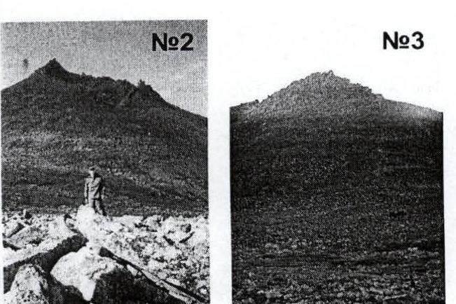
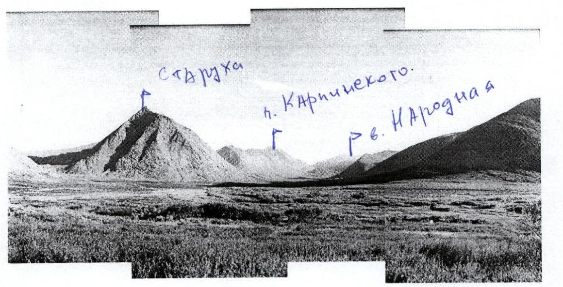
Photo #1 — panorama of the mountain horseshoe of the upper reaches of the Балбанъю (Balban'yu) River. In the background:
- пик Карпинского (Mount Karpinsky);
- г. Народная (Mount Narodnaya).
Photo #2 — peak Старуха (Starukha) from the Леля-гладь (Lelya-glad') valley.
Photo #3 — peak Старуха (Starukha) from the all-terrain vehicle road leading to the Сюрэсь (Syures') tract.
Peak Старуха (Starukha) (1439 m)
Route: via the northeast ridge — 2A category.
Natural sports ground (P SP): "Долина Балбанъю" (Balban'yu Valley). Natural sports complex (P SK): "Приполярный Урал" (Subpolar Urals).
View of the peak from the all-terrain vehicle road leading to the Сюрэсь (Syures') valley. Base camp "Reindeer herders' camp near Lake М. Балбанты (M. Balbanty)".
Inscriptions on the map:
- База Желанная (Zhelannaya Base);
- Стоянка оленеводов (Reindeer herders' camp);
- Северо-восточный гребень 2А (Northeast ridge 2A);
- Южный гребень 2Б (South ridge 2B).
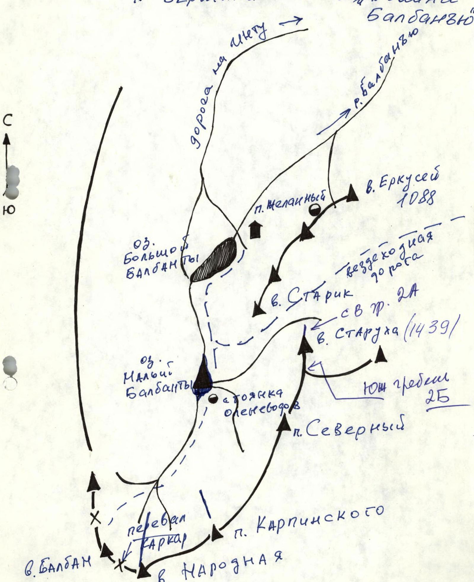
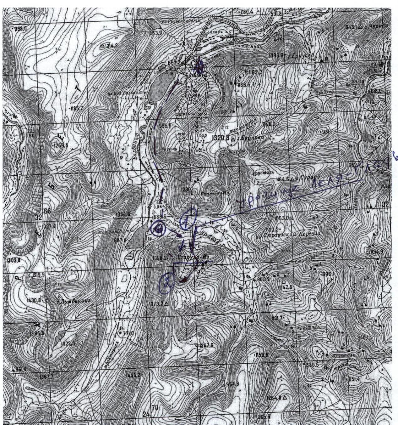
Scheme of approaches to the peaks of the P SP "Долина Балбанью" (Balban'yu Valley):
- Озеро Большой Балбанты (Lake Bolshoy Balbanty);
- Озеро Малый Балбанты (Lake Maly Balbanty);
- Посёлок Желанный (Zhelanny settlement);
- Вершина Еркусей (Yerkusei peak) (1088);
- Вершина Старик (Starik peak) (northeast ridge 2A);
- Вершина Старуха (Starukha peak) (1439);
- Южный гребень 2Б (South ridge 2B);
- Посёлок Северный (Severny settlement);
- Перевал Каркар (Karkar pass);
- Пик Карпинского (Karpinsky peak);
- Вершина Народная (Narodnaya peak).
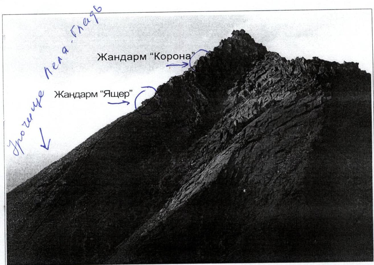
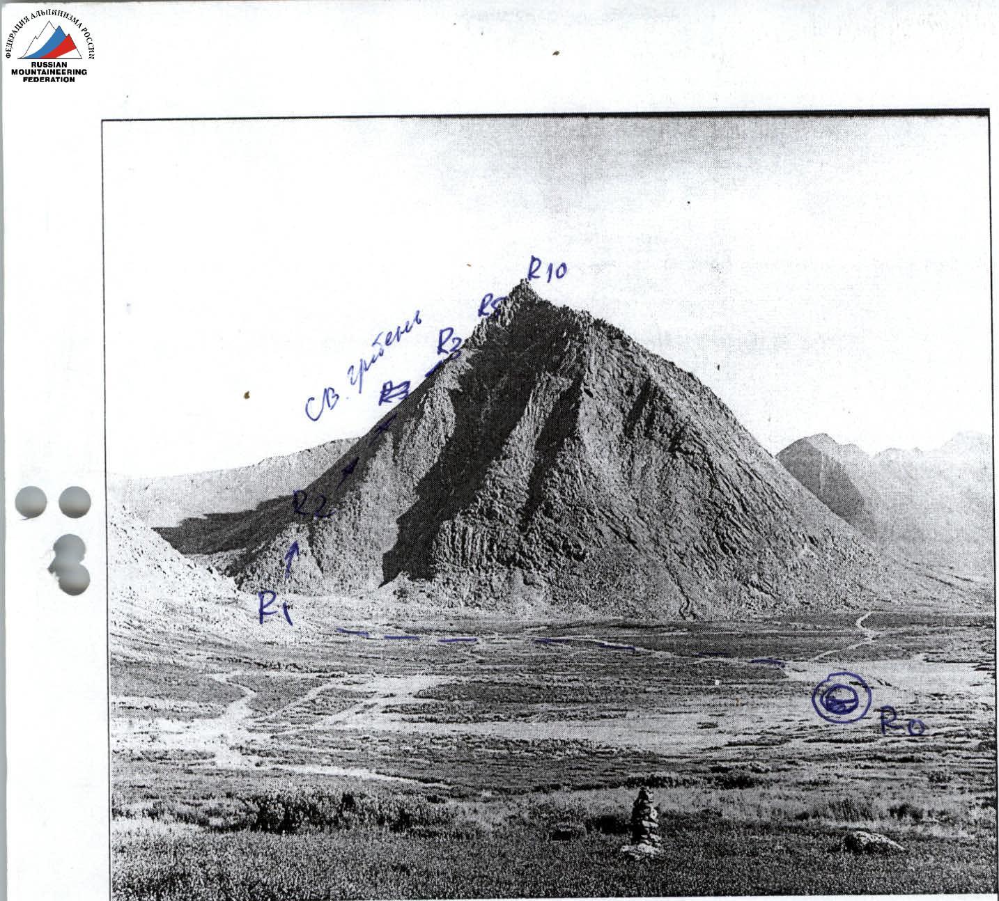
Top: Close-up of the technical part of the route via the northeast ridge to peak Старуха (Starukha) 2A category. The visible part of the route from the northwest (from the Балбанъю (Balban'yu) River valley) is outlined.
Bottom: View of peak Старуха (Starukha) from the base camp on the shore of the Балбанъю (Balban'yu) River near Lake Малый Балбанты (Maly Balbanty) (reindeer herders' camp). The approach from the base camp to the start of the route and its technical part up to the gendarme "Ящер (Yashcher)" is outlined. At the foot of the gendarme "Ящер (Yashcher)" is a control cairn.


Tactical plan for the ascent via the NE ridge — 2A category.
R0 — bivouac near the reindeer herders' camp by Lake Верхний Балбанты (Verkhny Balbanty).
R0–R1 — approach to the start of the route, to the scree eastern spur of the south ridge. (Trail, tundra, talus. 4 km, easy terrain). R1–R2 — ascent onto the scree spur of the south ridge. (Scree slope. Slope steepness 50–60°, easy terrain). R2–R3 — inner angle "Книга (Kniga)" (key part of the route!). (Rocks. 40 m. 70–75°. Difficulty level — 2+. At the exit from the inner angle — 7 m, 90°, — 3+. Piton belay). R3–R4 — movement along a series of oblique, inclined rock shelves through the "Ворота (Vорота)" formed by two feathery gendarmes. (Rocks. 150–200 m. Steepness 45–50°. 2B category. Alternate belay). R4–R5 — overcoming the "Провал (Proval)". (Rocks. Difficulty level — 2B category). R5–R6 — traverse right along a rock shelf to the block "Кирпич (Kirpich)". (Rocks. 100 m. 2B category). R6–R7 — exit onto the ridge of the counterfort. (Rocks. Wall — 10 m. 90°. 3B category, 2B category). R7–R8 — movement along the ridge of the counterfort with an exit onto the south ridge. (Rocks. 40 m. 65–70°. 2B category, 2B category. Alternate belay). R8–R9 — movement along the ridge and traverse around the southern summit tower. (Rocks — 1 category). R9–R10 — exit onto the summit tower (central of three). (Rocks. Wall 30 m. 65–70°. 2+). R10 — summit Старуха (Starukha).
Tactical Ascent Plan
R0 — bivouac near the reindeer herders' camp by Lake Верхний Балбанты (Verkhny Balbanty).
R0–R1:
- approach under the start of the route, to the scree "paw" of the base of the northeast ridge;
- steepness 45°;
- 1.5–2 hours;
- easy terrain.
R1–R2:
- ascent onto the scree shoulder;
- slope steepness 50–60°;
- 1 hour;
- easy terrain.
R2–R3: ascent to the base of the rock ridge under the gendarme "Ящер (Yashcher)". (At the foot of the gendarme "Ящер (Yashcher)" is a control point). Slope steepness 50–60° — 1.5 hours. Large-block scree. Easy terrain.
R3–R4: movement along large rock blocks to the left of the gendarme "Ящер (Yashcher)". Simultaneous movement on a shortened rope, with the rope laid around outcrops. Length: 300–350 m. Difficulty level — 1+, 2.
R4–R5: bypassing the gendarme "Корона (Korona)" to the left. Passing an inclined wall. (Key part of the route!)
- 45 m;
- Difficulty level — 3+;
- Organized belay.
R5–R6: traverse right along a rock shelf.
- 100 m;
- Rocks 1+.
R6–R7: traverse under a cornice with an exit onto the ridge. Wall 10 m.
- Difficulty level — 3.
R7–R8: movement along the ridge to the base of the inner angle.
- 80 m;
- Difficulty level — 2+;
- Alternate belay.
R8–R9 — inner angle leading to the saddle between the first and second summit towers. 60 m. Difficulty level — 2+. Alternate belay. Possibility of using a fixed rope.
R9–R10: exit onto the summit tower (central of three). 30 m. Rocks 2+.
R10 — summit Старуха (Starukha). R10–R11 — oblique traverse of the summit towers along the left part of the ridge. 60 m. Rocks 1–2.
R11–R12 — rappel 30 m with a transition across the edge of the counterfort. Then 5 m descent onto a large horizontal rock block "Кирпич (Kirpich)". On the transition across the counterfort — a loop for pulling through for the last person. (Difficult rock section, steepness 90°).
R12–R13 — traverse along a rock shelf past the through passage "Тоннель (Tonnely)" in the south ridge. 200–250 m. Rocks 1–2. Simultaneous movement.
R13–R14 — overcoming a vertical break in the ridge. Alternate belay. Section 1.5 m, difficulty level 2+. Mandatory fixed rope for " badge climbers".
R14–R15 — descent along inclined slabs into the passage between two gendarmes — "Ворота (Vорота)". Steepness 45°. 100 m. Rocks 2.
R15–R16 — descent along the inner angle "Книга (Kniga)" to the southern base of the rock tower of peak Старуха (Starukha). Steepness 65–70°. 50 m. Rocks 2.
R16–R17 — movement along the scree south ridge to the descent couloir to the left into the Леля-гладь (Lelya-glad') valley.
R17–R0 — return to the bivouac near the reindeer herders' camp by Lake Малый Балбанты (Maly Balbanty).
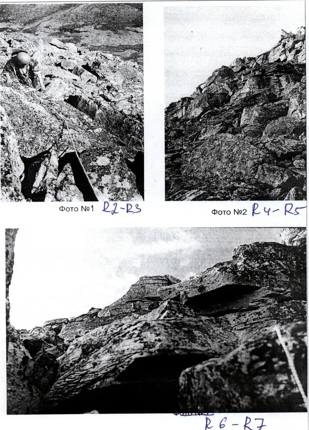
Photo #1: transition from large-block scree to rocks. Simultaneous movement with gymnastic belay. Photo #2: start of the rock section from the control cairn bypassing the gendarme "Ящер (Yashcher)". Photo #3: first rope of the key section.
Comments
Sign in to leave a comment