

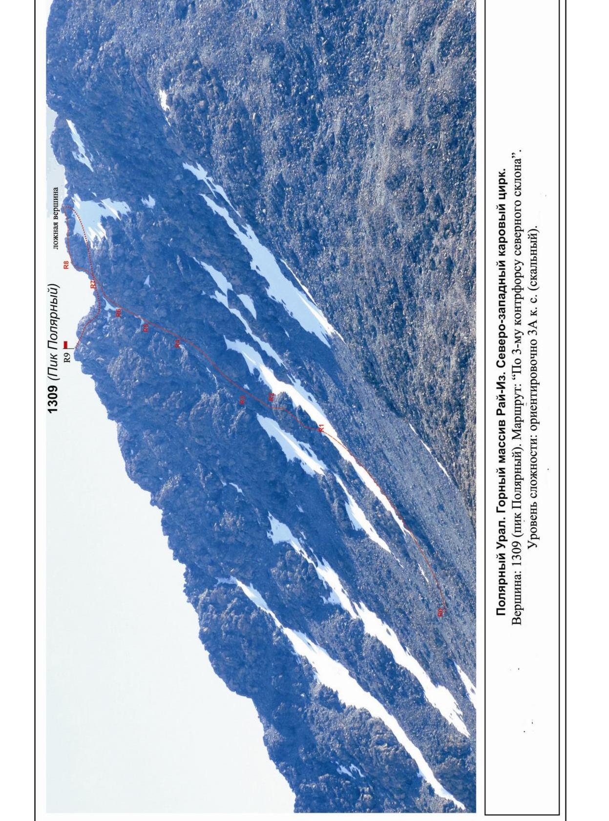
Polar Urals. Rai-Iz mountain massif. North-Western cirque. 1309 summit (Polar Peak).
Passport
- KMGV section number — 2010 — 8.3.
Polar Urals, Rai-Iz mountain massif (north-western cirque), Sob River valley.
- Summit name: 1309.0 (Polar Peak)
height: 1309.0
- Route: via the third counterfort of the northern slope.
- Difficulty category: proposed 3A category.
- Route type — rock climbing.
- Route height difference: 650 m
- Route length: 690 m
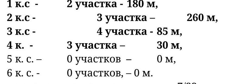
- Technical sections length and complexity level:
| 1st category — | 2 sections — 180 m, | |
|---|---|---|
| 2nd category — | 3 sections — | 260 m, |
| 3rd category — | 4 sections — 85 m, | |
| 4th category — | 3 sections — | 30 m, |
| 5th category — | 0 sections — | 0 m, |
| 6th category — | 0 sections — 0 m. |
- Average steepness: main part of the route — 55°. Crux — 80°. □
- Pitons used:
Used in total on the route:
- rock pitons — 7 pcs
- закладок — 22 pcs
- стационарных шлямбурных — 0
- ИТО — 0
- съёмных шлямбурных — 0
Left on the route: total — 0; including шлямбурных — 0.
- Exit to the route — 6:00, July 3, 2015.
Reached the summit — 14:00, July 3, 2015. Returned to BL — 16:00, July 3, 2015.
- Team's walking hours: — 10 h.
- Leader: A. Goletarov (Inta, 2nd sports category).
Participants: V. Disnenko (Inta, 2nd sports category), S. Nikolaeva (Voronezh, 2nd sports category).
- Coach: Sergey V. Zhuravlev (Syktyvkar, Candidate for Master of Sports, category 1 instructor-methodologist).
Summit description
The 1309 summit (Polar Peak) is one of the summits of the Raiiz massif, located in the Yamalo-Nenets Autonomous Okrug (YNAO) of the Tyumen Oblast, Ural Federal District, Russian Federation, on the eastern slopes of the Polar Urals, on the north-west of the Raiiz massif, on the watershed of the following river valleys:
- Nyrdvom-Shor (north)
- Sob (west)
- Enga-Yu (south-east).
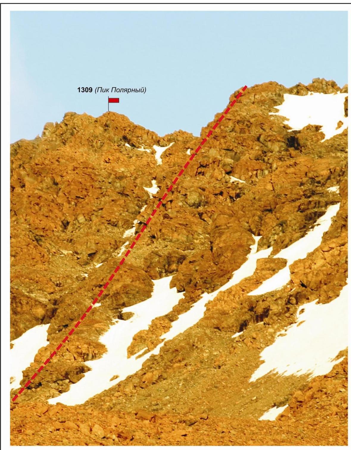
The 1309 summit (Polar Peak) is a pronounced pyramid. Height — 1309 m. The name is unofficial but has become established in the mountaineering community, allowing the summit to be identified as an object of sporting ascents.
The following routes are classified on the 1309 summit (Polar Peak):
- "Via the south-eastern ridge — 1B category (combined)".
- "Via the western ridge" — 1B category (winter).
- "Via the north-eastern ridge — 2A category (combined)".
The development of mountaineering resources continues. As part of the Cup of the NP "Klub severnykh puteshestvii 'Sauk-Pai'", new route ascents were made in 2015:
- Via the southern couloir of the western ridge and the western ridge — 1B category (combined).
- Via the southern ridge — 2A category (combined).
- Via the third counterfort of the northern slope — 3A category (rock climbing).
Route description: "via the third counterfort of the northern slope — 3A category (rock climbing)".
Route: "Via the third counterfort of the northern slope — 3A category (rock climbing)".
- A typical sporting and training route of the 3rd category, with a full range of natural obstacles.
- Logical: the route follows a clearly defined rock counterfort.
- Relatively safe: falling rocks follow small couloirs away from the climbers' path.
- Uniform in difficulty.
- Has several short sections of difficult climbing (4-5 m) and a technically complex crux (40 m), requiring good technique and organization of intermediate anchors.
- Passing this route has not only aesthetic but also practical training value, as it allows climbers to practice belaying and self-belaying techniques, as well as tactical skills on complex rock terrain.
The route is ridge-like, allowing for safe sporting and training ascents in the summer.
Equipment
For a 4-person training group, the following special equipment is required:
Personal:
- Standard equipment
- Crampons — only necessary in winter or during the off-season
- Ice axe — only necessary in winter or during the off-season
Group:
- Main rope 10 mm — 2×50 m
- Carabiners (with screw gates) — 8 pcs.
- Rock hammer — 1 pc.
- Rock pitons — 6 pcs.
- Ice axe — 1 pc.
- Chocks — 12 pcs
- Friends — 4 pcs (large sizes)
- Quickdraws — 12 pcs
- Slings — 10 pcs
- Primus or gas
- Burner
- Cooking vessel
Approach
From the base camp, located near the Perevalnoye Lake in the vicinity of the Polar Urals railway station, follow the Sob River valley to the confluence of several streams forming the Sob River (about 3 hours).
At this location:
- There are suitable places for setting up tents (lower Sob bivouac)
- A ford across the Sob River is nearby (40 cm deep during the dry season)
- Water is flowing
- Cooking can be done using a primus or gas
Strong winds are possible in the Sob River valley, so it is recommended to protect tents with stone or snow walls.
From the lower Sob bivouac, cross the Sob River and move along the right-bank unnamed tributary to its headwaters, towards the western spur of the Polar Peak, which divides the north-western cirque of the Raiiz massif into two parts.
The left part of the north-western cirque is formed by:
- The western spur running from the 1287 m summit
- The rocky ridge running from the 1287 m summit north-east to south-west towards the 1309 summit (Polar Peak)
- The western spur running from the 1309 summit (Polar Peak)
Move across the mountain tundra along the northern slopes of the western spur of the 1309 summit (Polar Peak) — to the right as you ascend — along the valley of the unnamed stream to the mountain cirque lake.
From the lake, the route is visible — the third counterfort of the northern slope of the Polar Peak. There are suitable places for setting up tents near the lake, and water is available for camping in case of bad weather.
Using these sites from October to May is not recommended due to the risk of avalanches. In June (until July 25), they are still snow-covered, and it's better to camp lower down.
Technical part
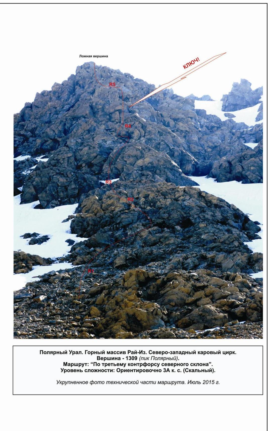
From the lake, ascend via scree to the base of the third counterfort (about 300 m). Organize rope teams under the counterfort. The rock climbing section begins with ascending a rocky ridge on the counterfort. Start by moving up the right-hand side, then follow a pronounced internal angle (30 m) and a series of inclined ledges to ascend to the scree ridge. Follow the ridge to a ledge under the second internal angle (15 m, 3+ category).
The angle is formed by smoothed rocks of moderate steepness with minimal natural features for intermediate anchors. (This is the "small key"! Here, the group can assess their readiness for the route. If in doubt, they can safely abandon the ascent.)
On the ledge under the internal angle, there is a suitable place for a belay stance. The basic stance is a sling on a large rock fragment. After passing the internal angle, there is a convenient stance with a sling on a large rock outcrop.
Further on, there is a prolonged section of alternating features:
- Internal angles
- Slabs
- Walls
- Inclined ledges
- Uniformly complex climbing
In the middle of the section, a monolithic rock wall is bypassed on the right via two inclined ledges. The terrain for intermediate anchors is varied, with large slings and friends mainly used.
A series of three short walls after the bypass leads to the crux of the route. The stance under the crux is on a convenient ledge, assembled from:
- A sling on an outcrop
- Two medium-sized chocks
- A counter-chock or piton
Crux
The crux is a complex wall section requiring skills in stemming, power climbing, and crack climbing with anti-rope protection. Located in the upper part of the route before reaching the pre-summit ridge.
Starts with passing an internal angle of moderate steepness, leading under a cornice. Then:
- Move up a crack with anti-rope protection, deviating to the right (15 m, 60°, 3+)
- Traverse under the cornice (power climbing in an off-balance position — 10 m, 90°, 4+)
- Exit through the cornice onto the ridge bend (with a resting place)
- Move up a steep, smoothed wall (5 m, 80°, 4−) to the left
- Pass a steep internal angle (10 m, 70°, 4−)
When passing the crux, use:
- Chocks in the crack of the first internal angle
- Pitons when traversing under the cornice and on the wall
- Chocks when passing the second internal angle
After the crux, there is an exit onto an inclined ledge under a diagonal wall. A convenient stance is assembled from a sling on an outcrop and large chocks, one of which is placed on a counter-pressure to secure the sling.
Further:
- An inclined wall (50 m, 55°, 3−) with numerous large outcrops and convenient holds
Leads to an inclined ledge, running to the right. Ascend the ledge to a destroyed rocky ridge. Follow the ridge to approach the rocky belt.
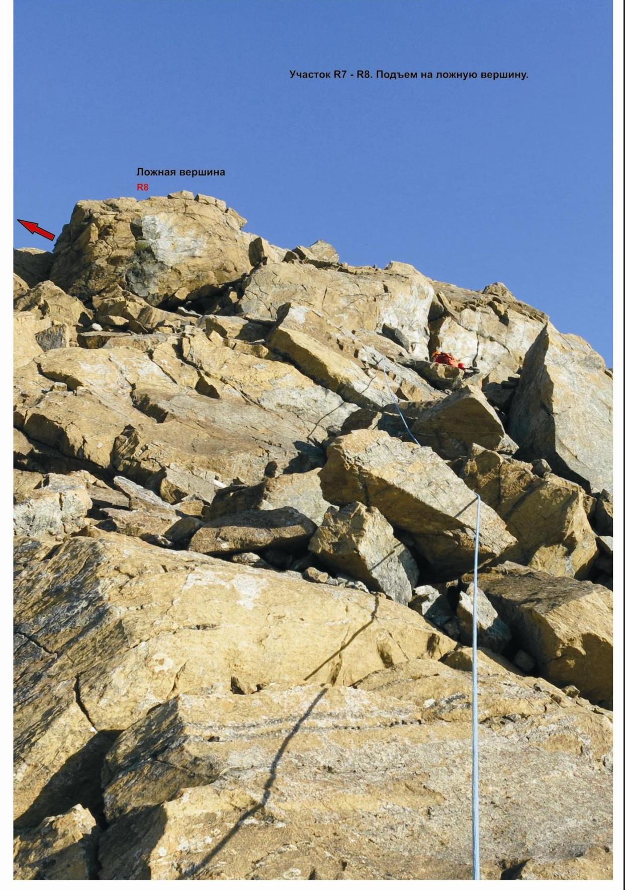
The rocky belt is technically complex but short (4 m, 80°, 4−).
After passing the rocky belt, there is an exit onto the destroyed pre-summit ridge, leading to the false summit. From the false summit, the ascent to the 1309 summit (Polar Peak) is straightforward.
Summit
The summit is clearly defined, with a cairn in the center made of large stone blocks, marked by a wooden post.
Descent
Via the western ridge and the southern couloir of the western ridge (1B category route).
Polar Urals. Raiiz mountain massif. North-Western cirque. Summit — 1309 m (Polar Peak). Route: "Via the third counterfort of the northern slope". Category: approximately 3A (rock climbing).
Photo-profile from the north-west, showing the average steepness of the route. July 2015.
Polar Urals. Raiiz mountain massif. North-Western cirque. Summit — 1309 m (Polar Peak). Route: "Via the 3rd counterfort of the northern slope". Category: approximately 3A (rock climbing).
Polar Urals. Raiiz mountain massif. North-Western cirque. Summit — 1309 m (Polar Peak). Route: "Via the third counterfort of the northern slope". Category: approximately 3A (rock climbing).
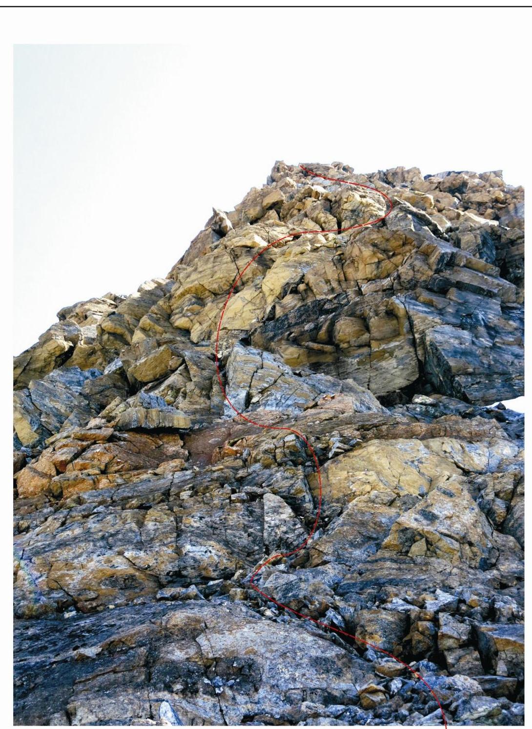
Enlarged photo of the technical part of the route. July 2015.
Polar Urals. Raiiz mountain massif. North-Western cirque. Summit: 1309 m (Polar Peak). Route: "Via the third counterfort of the northern slope". Category: approximately 3A.
Table of natural obstacles on the route:
| Section | Length | Steepness | Terrain characteristics | Category | Number of pitons/chocks |
|---|---|---|---|---|---|
| APPROACH | From base camp to lower Sob bivouac and then to the base of the third counterfort — 2 h 30 min. | Photo №1 | |||
| R0–R1 Ascend to the base of the counterfort | 150 m | 20° | Scree | n/k | Used 0/0 Left 0/0 Photo №3, 4 |
| R1 | Scree at the base of the northern ridge. Suitable for organizing rope teams | Photo №3, 4, 5 | |||
| R1–R2 Ascend to the rocky ridge of the counterfort | 40 m | 45° | Ledges, internal angle | 2- | Used 0/0 Left 0/0 Photo №5 |
| R2–R3 Pass the "small key" section | 15 m | 45° | Internal angle. Monolithic dense rocks | 3- | Used 0/2 Left 0/0 Photo №6 |
| R3–R4 Pass the "assortment" section. Approach to the crux | 200 m | 55° | Series of short (5-7 m) sections of varying difficulty: walls, slabs, internal angles, and traverses on inclined ledges | 2+ | Used 0/4 Left 0/0 Photo №7, 8 |
| R4–R5 Pass the crux | 15, 10, 5, 10 m | 60, 90, 80, 70° | Internal angle with a crack. Traverse under the cornice (power climbing). Wall. Internal angle | 3+, 4+, 4- | Used 4/8 Left 0/0 Photo №9, 10 |
| R5–R6 Pass the diagonal internal angle | 50 m | 60° | Diagonal internal angle | 3 | Used 2/5 Left 0/0 Photo №11 |
| :--: | :--: | :--: | :--: | :--: | :--: |
| R6–R7 Exit to the diagonal ledge and traverse to the right | 3, 15, 80 m | 80, 15° | Wall. Diagonal ledge. Destroyed rocky ridge | 3+, 2-, 1 | Used 0/3 Left 0/0 Photo №11 |
| R7–R8 Pass the upper rocky belt | 4 m | 80° | Rock monolith, internal angle | 4- | Used 1/0 Left 0/0 Photo №12 |
| R8–R9 Ascend to the summit via the scree ridge | 100 m | 15-20° | Destroyed rocky ridge, scree | 1, n/k | Used 0/0 Left 0/0 Photo №13 |
| R9 — summit 1309 (Polar Peak) | Pyramidal, clearly defined, with a cairn in the center, marked by a wooden post | Photo №14 | |||
| DESCENT | Via the western ridge and the southern couloir of the western ridge (1B category route) |
Summary
Route length — 690 m, technically complex section — 555 m.
Average steepness — 55°, crux — 80°
Terrain type — rock climbing
Technical sections:
Pitons and chocks used: 7 (22) pcs.
Pitons and chocks left: 0 (0) pcs.
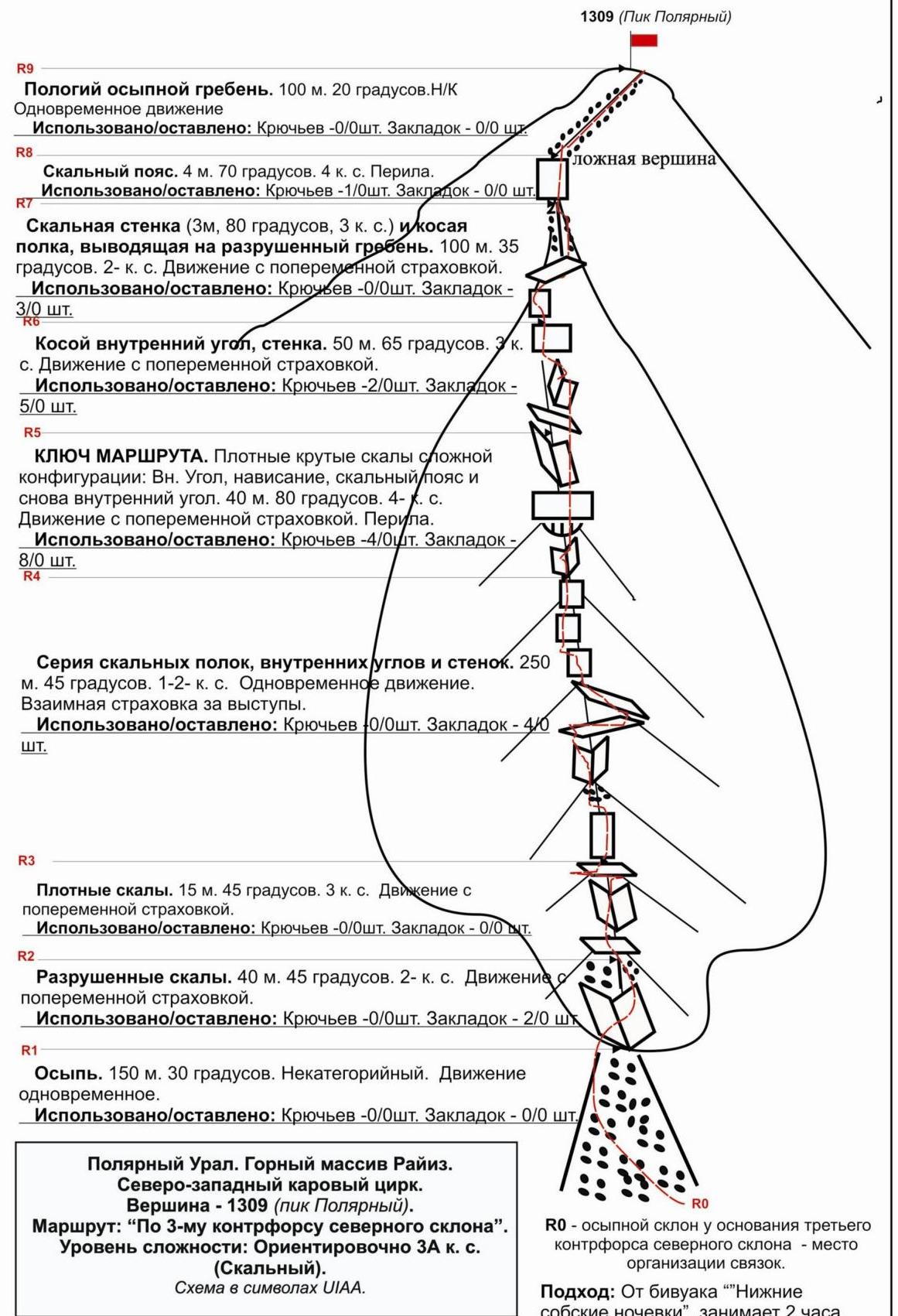
Gentle scree ridge. 100 m. 20°. n/k. Simultaneous movement.
Used/left: Pitons — 0 (0) pcs. Chocks — 0 (0) pcs.
R8. Rocky belt. 4 m. 70°. 4th category. Rappel.
Used/left: Pitons — 1 (0) pcs. Chocks — 0 (0) pcs.
Rock wall (3 m, 80°, 3rd category) to a diagonal ledge, leading to a destroyed ridge. 100 m. 35°. 2nd category. Movement with alternating belay.
Used/left: Pitons — 0/0 pcs. Chocks — 2/0 pcs.
Diagonal internal angle, wall. 50 m. 65°. 2nd category. Movement with alternating belay.
Used/left: Pitons — 2/0 pcs. Chocks — 5/0 pcs. R9 CRUX.
Dense, steep rocks of complex configuration:
- Internal angle
- Overhang
- Rocky belt
- Internal angle again
40 m. 80°. 4th category. Movement with alternating belay. Rappel.
Used/left:
- Pitons — 4/0 pcs.
- Chocks — 8 (0) pcs.
Series of rocky ledges, internal angles, and walls. 250 m. 45°. 1st-2nd category. Simultaneous movement. Mutual belay on outcrops.
Used/left:
- Pitons — 0 (0) pcs.
- Chocks — 4 (0) pcs.
R3. Dense rocks. 15 m. 45°. 3rd category. Movement with alternating belay.
Used/left:
- Pitons: 0 (0) pcs.
- Chocks: 0 (0) pcs.
R2. Destroyed rocks. 40 m. 45°. 2nd category. Movement with alternating belay.
Used/left:
- Pitons: 0 (0) pcs.
- Chocks: 2 (0) pcs.
R1. Scree. 150 m. 30°. Non-category. Simultaneous movement.
Used/left:
- Pitons: 0 (0) pcs.
- Chocks: 0 (0) pcs.
Polar Urals. Raiiz mountain massif. North-Western cirque. Summit — 1309 m (Polar Peak). Route: "Via the 3rd counterfort of the northern slope". Category: approximately 3A (rock climbing).
UIAA symbol scheme.
R0 — scree slope at the base of the third counterfort — location for organizing rope teams. Approach from the "lower Sob bivouac" takes 2 hours.
Polar Urals. Raiiz mountain massif. North-Western cirque. Summit — 1309 m (Polar Peak). Route: "Via the third counterfort of the northern slope". Category: approximately 3A (rock climbing).
Characteristic rocks on the route:
- Section R5–R6
- Section R7–R8
- Ascent to the false summit
Comments
Sign in to leave a comment