Passport
- Section number according to KMGV — 2010 — 8.3. 45
Polar Urals, Raiiz mountain massif, Sob River valley.
- Name of the peak: 1309.0 (Pik Polyarný)
Height: 1309.0 m, route: south-eastern ridge.
- Category of complexity: proposed 1Bз., PP.
- Character of the route — combined.
- Height difference of the route: 540 m
- Length of the route: 3500 m
- Length of sections with the highest category of complexity:
R1–R3000 m, R2–500 m, R3–0 m, R4–0 m, R5–0 m, R6–0 m.
- Average steepness: main part of the route — 50 degrees.
entire route — 45 degrees.
9. Pitons used:
Total pitons used on the route:
- rock pitons — 0
- chocks — 0
- stationary pitons — 0
- ITO — 0
- removable pitons — 0
Left "piton" on the route: total — 0; including pitons — 0.
- Departure on the route — 7:00, March 12, 2006
Reached the summit — 15:30, March 12, 2006. Returned to BL — 17:00, March 12, 2006
- Team's walking hours: 8 hours.
- Leader: Goletarov Andrey Mikhailovich (2nd sports category, Inta).
Participants:
- L. Kaneva (3rd sports category, Syktyvkar)
- E. Burtsev (3rd sports category, Syktyvkar)
- K. Tolstikov (3rd sports category, Syktyvkar)
- Coach: Zhuravlev Sergey Vasilyevich, title — CMS, instructor-methodologist 1 category.
Description of the peak
Peak 1309 (Pik Polyarný) is one of the peaks of the Raiiz mountain massif, located in the Yamalo-Nenets Autonomous Okrug (YaNAO) of the Tyumen Oblast, Ural Federal District of the Russian Federation, on the eastern slopes of the Polar Urals, in the northwest of the Raiiz mountain massif, on the watershed of the mountain valleys of:
- Nyrdvom-Shor (north),
- Sob (west),
- Enga-Yu (southeast).
The peak is a pronounced three-faced pyramid. Height — 1309.0 m. The name is unofficial but has taken root in the tourist and mountaineering community. Peak 1309 (Pik Polyarný) can be an object of educational and sports ascents, as it has several pronounced rocky ridges.
Description of the route: "via the south-eastern ridge 1B category of complexity (combined)".
Route: "Via the south-eastern ridge 1B category of complexity (combined)" — a typical educational and training route of the first category of complexity, with a full range of natural obstacles. Passing this route has not only aesthetic but also practical educational and sports significance, as it allows working out belaying and self-belaying techniques on rocky and snowy-ice relief during the ascent. The route is ridge-like, allowing for educational and sports ascents:
- in winter
- in summer
Equipment
For an ascent as part of an educational and sports group of 6 people (5 participants + instructor) on the route, the following special equipment is required:
personal — standard, crampons and ice axe are mandatory;
group:
- main rope 10 mm — 3×50 m
- rock hammer — 1 piece
- rock pitons — 6 pieces
- ice axe — 1 piece
- chock stones — 6 pieces
- ice screws — 6 pieces
- quickdraws — 6 pieces
- slings — 8 pieces.
Approach
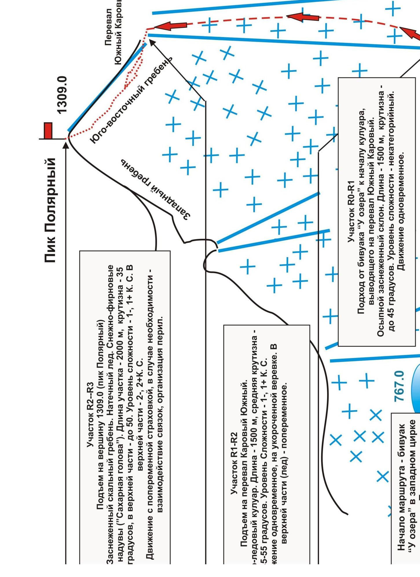
From the Polyarný Ural station of the northern railway along the Sob River valley — in winter on skis, in summer along a dirt road — the approach to the cirque formed by the western ridge of peak 1309 (Pik Polyarný), a common rocky ridge to the east, and the western ridge of peak 1287 (Pik Topografov), takes 4–6 hours.
The base camp is conveniently set up near a lake (elevation mark of the lake's water edge 667.0) on the talus fields of the mountain tundra. (Cooking — stoves, gas).
The route begins from the lake, located on the line of the mountain's foot.
Technical part
From the lake, ascend through a couloir to the Yuzhny Karový pass (in tourist classification 1B category of complexity), then — movement along the ridge.
A long rocky ridge is covered with 3–4 cm of ice (winter, very hard) in winter. Rocks of 1–2 category of complexity are sprinkled with snow. The ridge is built pyramidally, with natural steps 3–5 m high, without sharp drops in height to the depressions.
Movement is carried out with alternating belay, intermediate points:
- ridge outcrops,
- large stone blocks.
The ice depth is insufficient for using ice screws; using chock stones is difficult because the crevices are filled with ice.
Key section of the route
The key section can be considered the exit to the summit dome along rocky sections.
Descent from the summit
Via the ascent route. Raiiz mountain massif Peak 1309 (Pik Polyarný) Route: Via the
South-eastern ridge Level of complexity — 1B category.
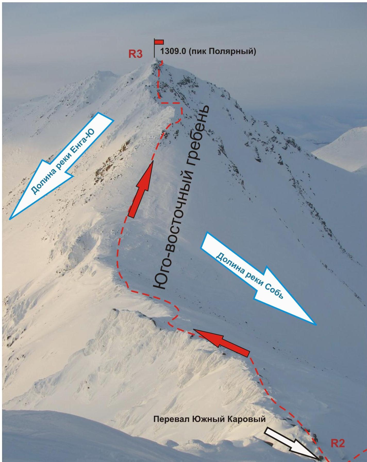
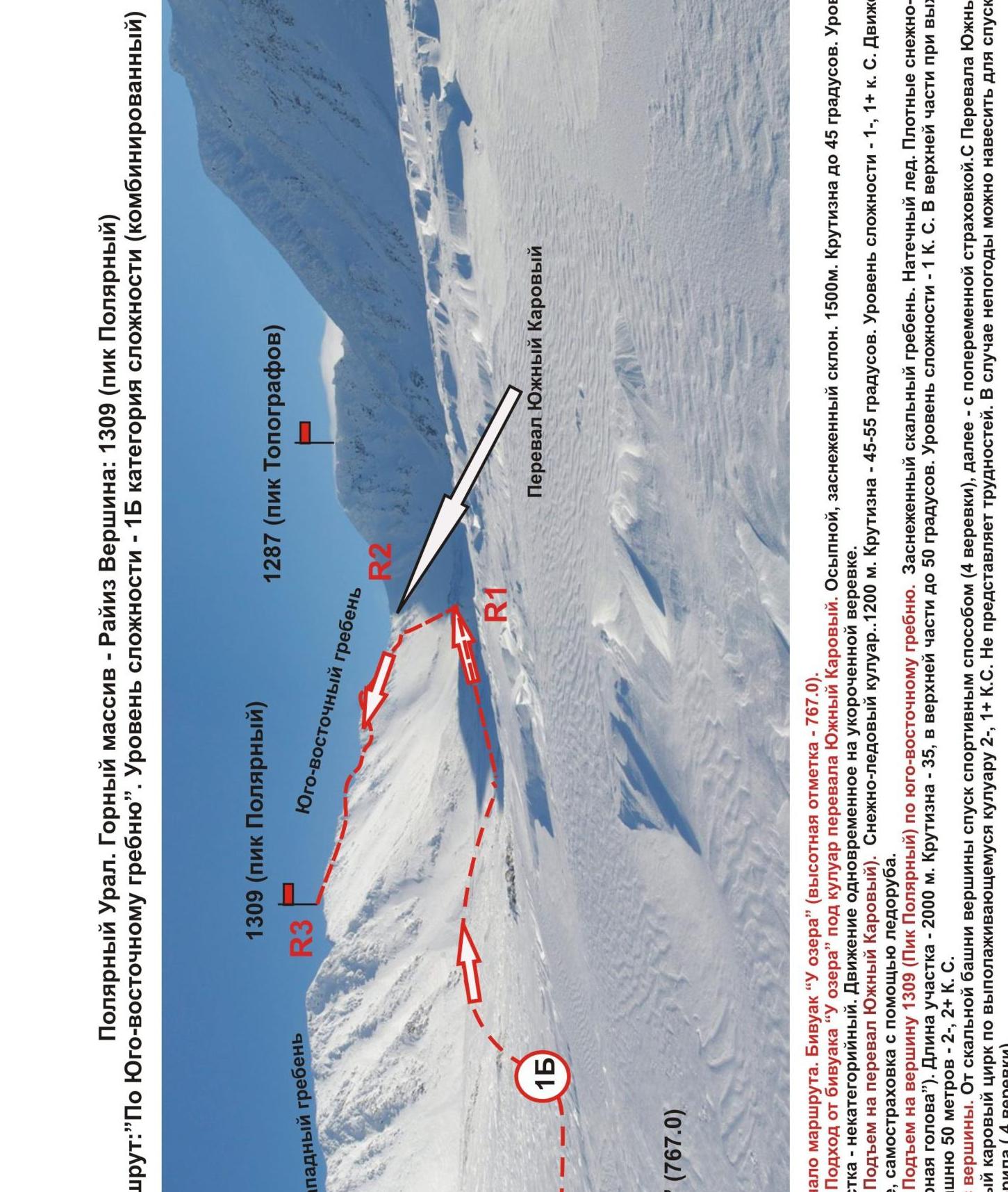
R0 — start of the route. Bivouac "U ozera" (elevation mark — 767.0 m). R0–R1 — Approach from bivouac "U ozera" under the couloir of Yuzhny Karový pass.
- Talus slope, snow-covered
- 1500 m
- Steepness up to 45°
- Level of extremity of the section — non-categorical
- Movement is simultaneous on a shortened rope
R1–R2 — Ascent to Yuzhny Karový pass. Snowy-ice couloir.
- 1200 m
- Steepness — 45–55 degrees
- Level of complexity — 1-, 1+ category of complexity.
- Movement is simultaneous, self-belaying with an ice axe
R2–R3 — Ascent to peak 1309 (Pik Polyarný) via the south-eastern ridge. Snow-covered rocky ridge. Ice formation. Dense snow-firn teeth ("Sugar Head").
Section length — 2000 m. Steepness — 35, in the upper part up to 50 degrees. Level of complexity — 1 category of complexity.
In the upper part, when exiting to the echelon tower:
- 50 m — 2-, 2+ category of complexity.
Descent from the summit. From the rocky tower of the summit, descent is by sports method (4 ropes), then — with alternating belay.
From Yuzhny Karový pass to the western kar cirque along a flattening couloir 2-, 1+ category of complexity. Does not present difficulties.
In case of bad weather, it is possible to hang rope railings for descent (4 ropes).
1309.0