
Ascent Log
- Region — Subpolar Urals
- Ridge — Researcher Ridge
- Gorge — mountain horseshoe of the Oleniy stream valley
- Section number according to KMGV-2001 — 8. "Other mountain systems, massifs"
- Other mountain systems, massifs:
- Peak name — Pobednaya
- Height: 1582
- Route name — via the western ridge
- Category of difficulty — Proposed category 3B
- Route character: Rocky
- First ascent — yes
- Note: The Alpinism Federation of the Komi Republic requests that the group that made this first ascent be credited with a 3B category route.
Height difference — 1200 m. Route length — 2000 m. There are no sections of category 5 or 6 difficulty. The average steepness of the main (technical part) of the route is 70°; the average steepness of the entire route is 55°. Pitons left on the route — 4; used pitons — none. Pitons used:
- horizontal — 6
- vertical — 4
- chock stones — 10.
Team's travel hours:
- Approach from the "Oleniy" shelter — 50 min
- Ascent from the "Oleniy" shelter bivouac — 10 hours.
Leader: Zhuravlev S. V. (Candidate for Master of Sports, instructor 2nd category). Team members:
- Afanasiev A. V. (3rd sports category, Inta)
- Ladokhina Yu. S. (3rd sports category, Inta)
- Petrov A. N. (3rd sports category, Inta)
Coach: Zhuravlev Sergey Vasilyevich, Candidate for Master of Sports, instructor 2nd category. Departure for the route — 7:00 July 7, 2004. Reaching the summit — 15:00 July 7, 2004. Return to the base camp — 18:00 July 7, 2004.
Organization: Monitoring scientific and sports expedition of the Alpinism Federation of the Komi Republic and the Yugyd Va National Park "Polar Vertical — 2004", second stage: July 1 — July 16, 2004.
Contact: Zhuravlev Sergey Vasilyevich, Syktyvkar, 167000, Internatsionalnaya st., 97, apt. 12, phone 24-24-91. E-mail: Zhur58@rambler.ru
Pobednaya Peak (1582 m)
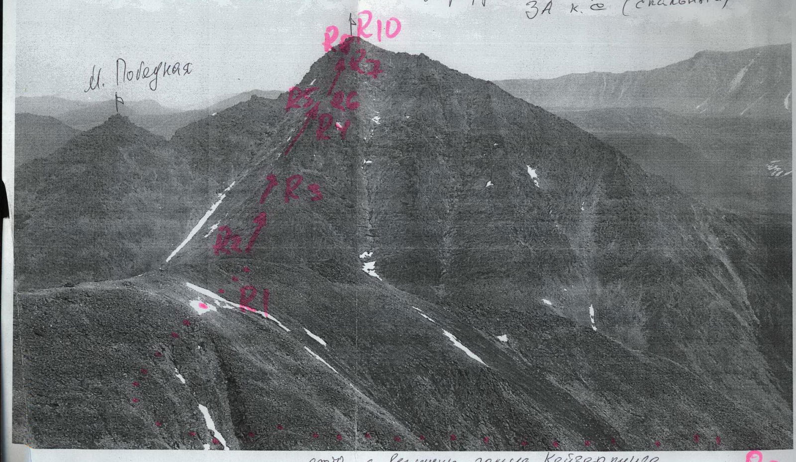
Ascent Diagram in UIAA Signs
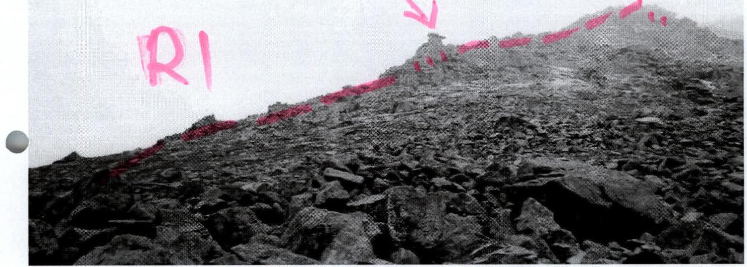
R0–R1 — approach to the base of the western ridge. To the base of the ridge under the "Grib" gendarme. (Trail. Scree slopes, talus, easy terrain).
R1–R2 — Movement along the right part of the ridge to the base of the chimney. (Rocky ridge. 300 m. Difficulty level 2–, 2+. Simultaneous insurance with rope placement behind outcrops. Alternating.)
R2–R3 — Exit to the first shoulder of the ridge. (Key point of the route!) Chimney 40 m, weakly expressed angle with a cleft — 20 m. (Rocks 3+, 4–. Steepness — 80–90°. Piton insurance, team interaction. Rappel lines.)
R3–R4 — Movement along the ridge to a pronounced series of gendarmes on the ridge — "Grebionka". (Destroyed rocks. 500 m. Sections 2–, 2+, 3– difficulty level. Alternating movement. Insurance via outcrops, occasionally piton insurance.)
R5–R6 — bypassing "Grebionka" via a traverse along inclined rock shelves on the left part of the ridge. (Destroyed rocks. 500 m. Sections 2–, 2+, 3– difficulty level. Overall steepness of the section 30–45°. Alternating movement. Insurance via outcrops, occasionally piton insurance.)
R6–R7 — Exit to the second rocky shoulder of the ridge. (Rock wall 3– difficulty level. 30 m. 75–80°.)
R7–R8 — Movement along the second rocky shoulder to the pre-summit wall. (Destroyed rocks. 100 m. Sections 2–, 2+, 3– difficulty level. Overall steepness of the section 30–45°. Alternating movement. Insurance via outcrops, occasionally piton insurance.)
R8–R9 — Passing the wall and exiting to the confluence of the northern and western ridges — the northern pre-summit. (Inclined wall. 30 m. 55–75°. Sections 3–, 3+ difficulty level. Piton insurance, team interaction. Rappel lines.)
R9–R10 — Movement along the northern ridge to the summit. (Destroyed rocks. 100–150 m. Sections 2–, 2+ difficulty level. At the exit to the summit — 1 difficulty level. Overall steepness of the section 30–45°.)
R10 — Pobednaya summit (1582 m).
R10–R0 — descent along the southern ridge (1B difficulty level).
There are no photos of the route's key points. Specifically, the Chimney (R2–R3) and Grebionka (R3–R4).

START of the Route GENDARM "GRIB" RI Pobednaya Peak (1582 m) is located in the highest part of the Subpolar Urals, in the Researcher Ridge, in the mountain horseshoe of the Oleniy stream, which flows into the Manaraga River. This is a well-defined rocky peak of alpine type. The local name Pobednaya is associated with the fact that to commemorate the 50th anniversary of the Victory in the Great Patriotic War, a group of tourists from the city of Inta ascended this peak via the non-category southeastern slope.
The peak is interesting for climbers primarily due to its rocky ridges and counterforts from the west, the northern ridge, as well as the eastern wall, which can be confidently classified as a challenging rock route in the Subpolar Urals.
The ascent via the western ridge was made by a sports group of climbers from Syktyvkar as part of the "Polar Vertical" monitoring expedition in August 2004.
Description of the Route — Object of Sports Ascent
Approaches to the base bivouac:
- From the Zhelannaya geologists' base through the Karkar pass
- or the Zigzag pass, cross over to the Manaraga River valley and approach the Oleniy shelter. This is a cabin located just below the mouth of the Oleniy stream. The journey takes two travel days.
Approach to the route: Further from the Oleniy shelter, follow a well-trodden geological and tourist trail along the right bank of the Oleniy stream (on the left as you move from the shelter), go upstream, exit the forest zone into the alpine zone. Then, in the upper reaches, cross to the left bank and approach the base of the western ridge along scree slopes. Then, along the scree slopes of the ridge "paw", ascend to a well-defined gendarme "Grib" on the ridge.
Technical part of the route: Under the "Grib" gendarme — a convenient place for a snack and organizing teams. Then, in teams, begin the ascent to the rocky ridge, sticking to the left side as you move. Movement along the ridge proceeds to an inclined chimney filled with large stone blocks. This is the most challenging part of the route. The chimney, 50–60 m long, leading to the main ridge, is climbed with intermediate piton (chock stone) insurance points. The upper part is the most difficult, narrowing to a cleft. The chimney leads to the first shoulder of the ridge. Further movement along the ridge to a rocky wall, which is passed on the right side. Piton insurance. Stations are convenient, organized behind outcrops, as well as "hourglasses" in the accumulation of large rock blocks. Then, again, movement along the ridge of medium climbing difficulty with insurance via ridge outcrops. The "Grebionka" gendarmes are bypassed on the left (as you move), along horizontal, multi-level rock ledges. Then, exit to the second shoulder of the ridge along an inclined rock wall of medium climbing difficulty, with an abundance of holds and footholds. Then, along the ridge to a rock ledge leading to the confluence of the northern and western ridges, forming the northern pre-summit. (In the lower part of this shoulder — the only place — a couloir allowing, in case of bad weather or unpreparedness of the group, to descend via rappels (five 45 m rappels, two of which are from overhangs). This place can be considered a turnaround point.) The wall leading to the northern pre-summit is technically not complex on the left side, about 30 m. Further movement to the summit along the ridge with alternating insurance via outcrops.
Descent: The descent is most conveniently organized along the southern ridge, but in case of bad weather (fog), a shorter but more complex descent via five rappels along a quite safe couloir from the second shoulder of the western ridge is possible.
Required equipment (calculation made for a sports group of discharge holders consisting of four people):
- main rope — 2×40
- carabiners — 10
- quickdraws — 10
- chock stones — a set of stoppers and a set of hexes, 15 pieces total
- rock pitons — 8 (3 horizontal, 3 vertical, 2 — angled)
- anchor loops — 8
- camping stove — 1
- pot — 1
- tent — 1
Recommendations for the instructor: In the summer, it is recommended to start the route (technical part) with a water reserve. In winter, the descent along the southwest couloir of the southern ridge is avalanche-prone — safer along the southern ridge. In the summer, the resource of time is supplemented by the polar day, in winter — complicated by the short daylight hours.
Time accounting:
- In the summer, the resource of time is supplemented by the polar day
- In winter — complicated by the short daylight hours.
Time required to complete the route: for a group of discharge holders of six people from the Oleniy shelter and back — 14–18 hours.

Map-scheme of approaches to the route to Pobednaya Peak (1582 m) via the Western Ridge 3A category. Scale: 1 cm — 500 m.
Profile of the Western Ridge of Pobednaya Peak (1582 m)
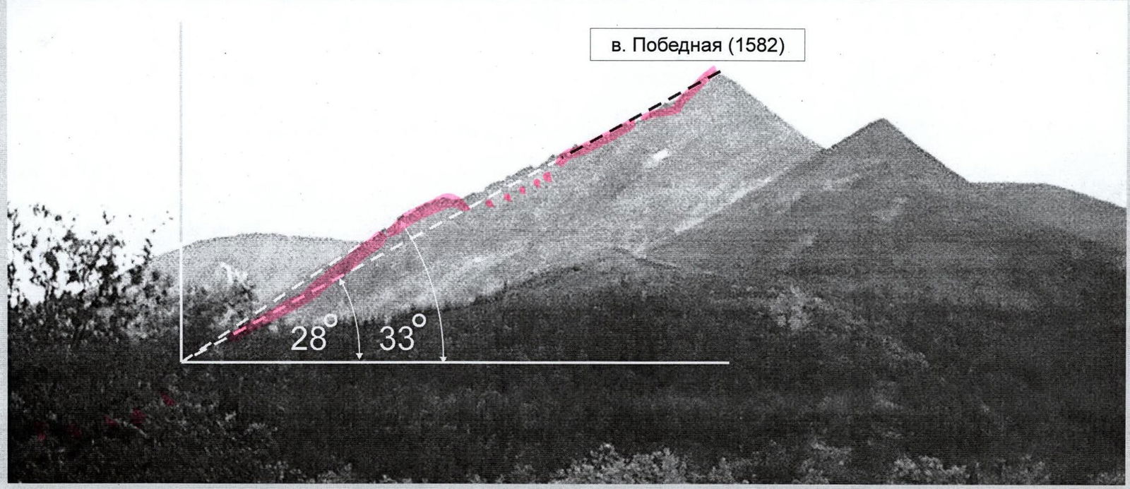
The route to Pobednaya Peak via the western ridge 3A category is a prolonged rocky ridge with an average steepness of about 28–33°. It consists of:
- stepwise wall sections;
- ridges;
- rock ledges of varying steepness;
- sections of varying difficulty levels.
The profile photo was taken from the mouth of the Oleniy stream, from the west.