
Ascent Passport
Region — Subpolar Urals. Ridge — Narod-Ityinsky Ridge (kряж). Gorge — Valley of the Bolshaya Lemva River. Mountain massif — Parnokaiz. Section number according to KMGV-2001 — #8. "Other mountain systems, massifs". Name of the summit — 1152 (Pernaiiz). Height — 1152 m. Route name — via the western ridge. First ascent. Proposed category of complexity for inclusion in the KMGV of the Russian Mountaineering Federation — 1B category (rocky).
Note: The Mountaineering Federation of the Komi Republic requests the classification commission of the FAR to credit the group of pioneers with an ascent of 2A category.
Height difference — 580 m. Route length — 2000 m. Average steepness of the main (technical part) of the route — 55°. Average steepness of the entire route — 30°. Sections of 3, 4, 5 and higher categories of complexity — none. No pitons left on the route. Time spent by the team on the ascent:
- Approach to the base camp (mothballed geologists' base "Lemva") from the miners' settlement Pachvoz — 2 days.
- Ascent from the base camp — 6 hours.
Leader (commander of the SP detachment): Kremen Anatoly Alekseyevich (CMS, instructor 1st category — cert. # 1073, Rostov-on-Don).
Participants:
- Toropov V. A. (3rd sports category, Syktyvkar)
- Gayner P. S. (3rd sports category, Syktyvkar)
- Ivonina I. V. (3rd sports category, Syktyvkar)
- Druzhinin E. V. (3rd sports category, Syktyvkar)
- Bondaruk P. A. (3rd sports category, Syktyvkar)
- Punanova A. A. (3rd sports category, Syktyvkar).
Coach — Kremen A. A. (CMS, instructor 1st category — cert. # 1073, Rostov-on-Don). Senior coach-supervisor — Fomenko Felix Nikolaevich (CMS, instructor 1st category — cert. # 7, Ukhta).
Departure on the route — 8:00, August 10, 2006. Arrival at the summit — 14:15, August 10, 2006. Return to base camp — 16:00, August 10, 2006.
Mountaineering event: Volunteer youth scientific-sports mountaineering expedition "Heights of the Native Land–2006", dedicated to the 85th anniversary of the statehood of the Komi Republic.
Executed by: Kremen Anatoly Alekseyevich, Zhuravlev Sergey Vasilyevich, Gayner Polina Sergeyevna. Syktyvkar 167000, Internatsionalnaya st., 97, apt. 12. Phone: 24-24-91. E-mail: Zhur58@rambler.ru
Mountaineering Federation of the Komi Republic
NP "Sauk-Pai Club of Northern Travels"
Club of Tourists and Climbers of Ukhta
Report on the First Ascent
Mountain region: Subpolar Urals. Gorge: Valley of the Bolshaya Lemva River. Ridge: Narod-Ityinsky Ridge (kряж). Mountain massif: Parnokaiz. Summit: 1152 (Pernaiiz). Route: via the Western Ridge. Proposed category of complexity for inclusion in the KMGV of the Russian Mountaineering Federation: 1B category (rocky). (It is proposed to credit the group that made the first ascent with an ascent of 2A category.)
Leader — commander of the SP detachment: Kremen Anatoly Alekseyevich. Date of ascent: August 10, 2006. Mountaineering event: Volunteer youth scientific-sports mountaineering expedition "Heights of the Native Land–2006", dedicated to the 85th anniversary of the statehood of the Komi Republic.
Senior coach-supervisor of the Mountaineering Federation of the Komi Republic: Fomenko F. N. (CMS, instructor 1st category, cert. # 7, Ukhta).
Deputy for safety (chief of rescue service) of the Mountaineering Federation of the Komi Republic: Zhuravlev S. V. (CMS, instructor 2nd category — cert. # 1124, badge — # 6190, Syktyvkar).
Report prepared by: expedition leader: Zhuravlev Sergey Vasilyevich.
Address: 167000, Syktyvkar, Internatsionalnaya st., 97, apt. 12. Phone: (8212) 24-24-91 (home). E-mail: Zhur58@rambler.ru
Syktyvkar, 2006.
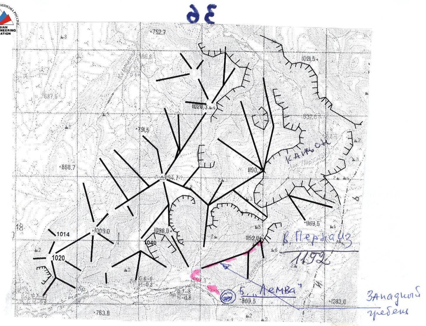
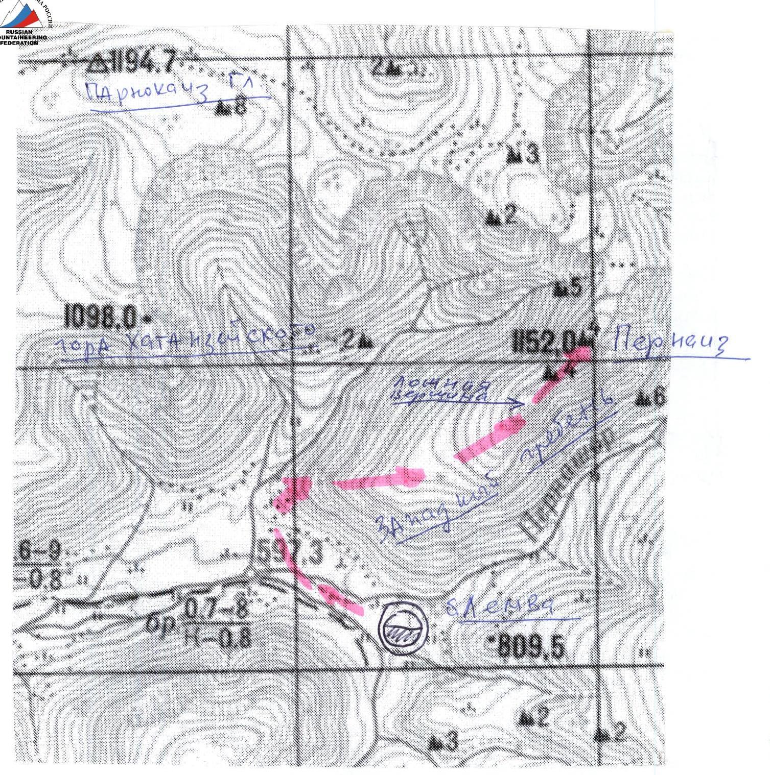
 Schematic map of the ridges (out of scale) of the Parnoksky mountain massif.
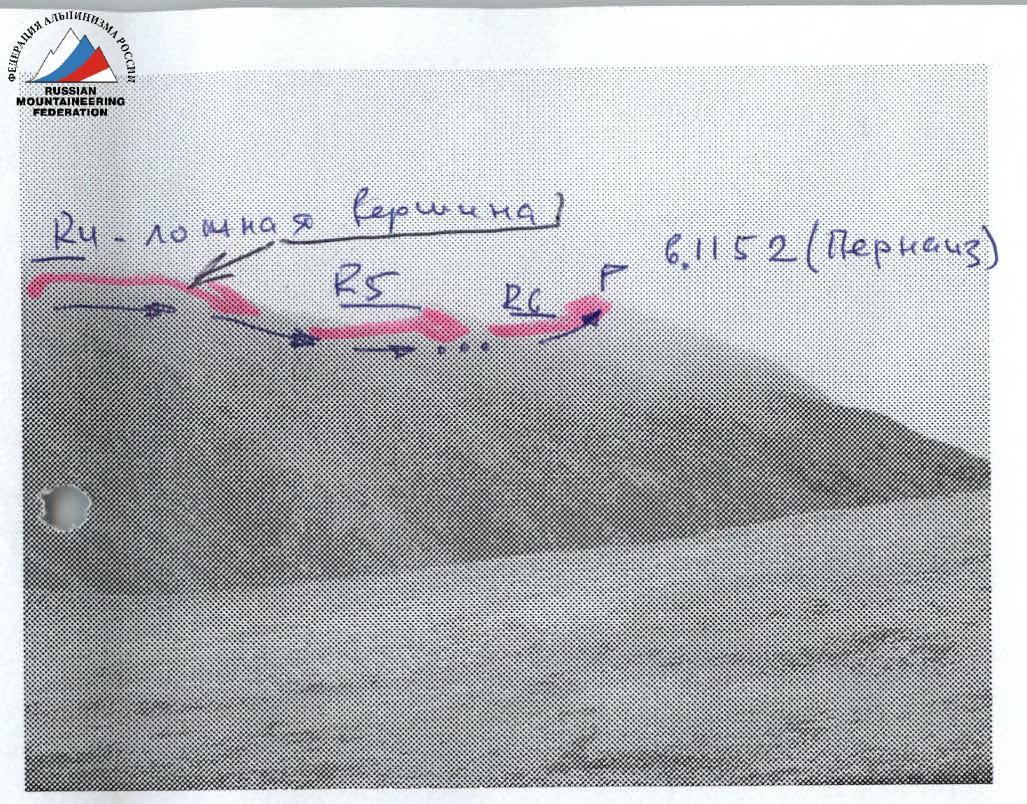 Upper part of the western ridge of Pernaiiz summit (profile from the southeast).
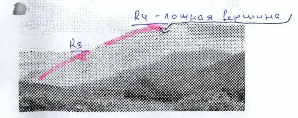 Lower part of the western ridge to the false summit of Pernaiiz (profile from the southeast).
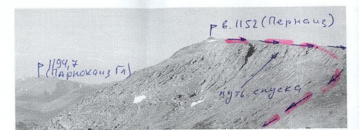 Pernaiiz summit and part of the eastern (descent) ridge (view from the east, the western ridge is not visible).
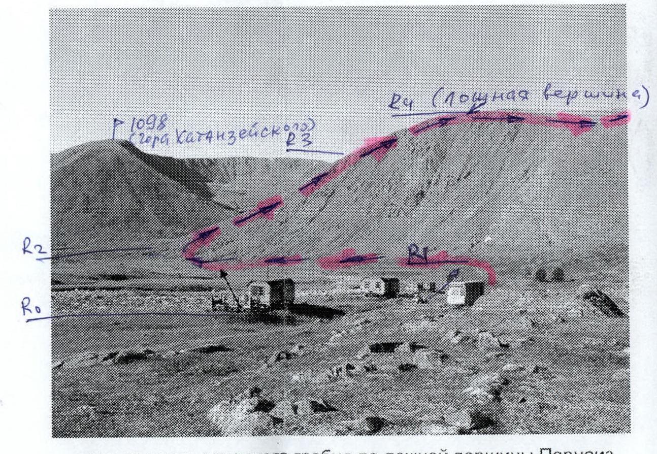 Lower part of the western ridge to the false summit of Pernaiiz (profile from the south) in the foreground is the mothballed geologists' base "Lemva".
Description of the Summit
The summit 1152 (Pernaiiz) is located in the southeastern part of the Parnokaiz mountain massif of the Narod-Ityinsky Ridge of the Subpolar Urals. The summit 1152 (Pernaiiz) is situated between the unnamed stream and the Pernashor stream, which flow into the Bolshaya Lemva River. It is a heavily destroyed mountain with a rocky ridge and a rocky tower at the highest point. The summit is characteristic and distinct, with a height mark on the map. The name of the summit is not indicated on the map. Pernaiiz is the local name of the summit, associated with the Pernashor stream, which flows around the summit from the north and northwest. The summit is called Pernaiiz by the reindeer herders — Ob Komi people from the village of Saranpaul, who graze their herds in the valley of the Bolshaya Lemva River during the summer.
Description of the Route
Approach: from the bivouac in the upper reaches of the Bolshaya Lemva River (mothballed geologists' base "Lemva": 3 cabins + bathhouse) exit down the river valley to the Pernavozh stream, which flows into the Bolshaya Lemva on the right. Cross the stream and approach the base of the scree slope of the western ridge of the summit 1152 (Pernaiiz). Here begins the technical part of the route along the western ridge.
Technical part of the route: Further up the large-block scree, ascend to the rocky inclined slabs. Organize rope teams under the slabs. Then, along the inclined series of rocky slabs, using small internal corners and alternating rocky ledges, ascend to the false summit. In the upper part, the rocks become more complex, and for novices, the organization of belays is required. From the false summit, along the wide scree ridge, approach a series of gendarmes. The rocky outcrops are bypassed on the left by a straightforward traverse. Then, approach the base of the rocky tower and make a straightforward ascent to the summit rocky tower along heavily destroyed rocks.
Descent path: via the ascent route. In winter, it is preferable to descend along the more secure route: via the eastern ridge.
 Schematic map of the ascent to 1152 (Pernaiiz) via the western ridge. The map is out of scale. Approximately 1 cm = 500 m.
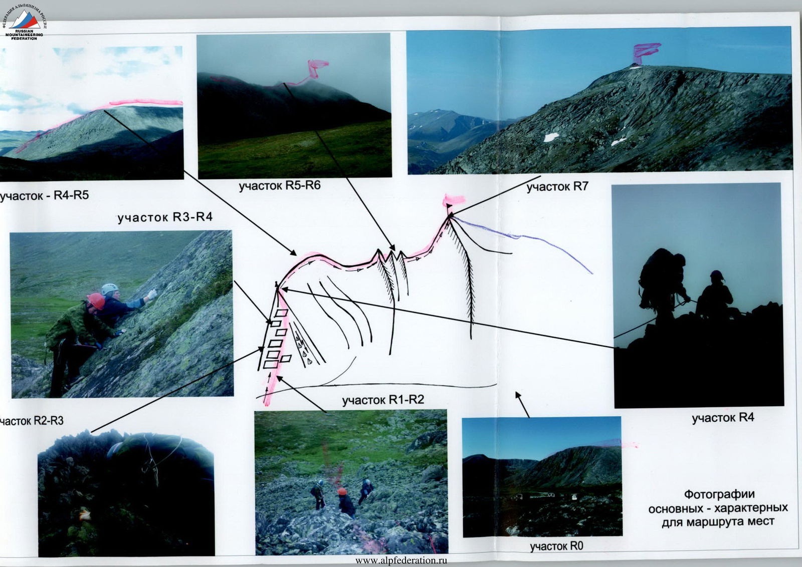
Scheme in UIAA signs. Summit 1152 (Pernaiiz). Route: via the western ridge
R0 — Bivouac in the upper reaches of the Bolshaya Lemva River (mothballed geologists' base "Lemva"). R0–R1 — Approach to the mouth of the Pernashor stream, crossing the Pernashor. All-terrain road, mountain tundra. Section length 500 m. Steepness of the section 10°. Technical difficulty level — non-categorized. R1–R2 — Approach to the start of the main part of the route to the base of the western ridge of Pernaiiz to the "rocky-scree slope". Large-block, medium-block scree. Section length — 300 m. Slope steepness — 30°. Technical difficulty level — 1. Movement to the place of rope team organization — simultaneous. R2–R3 — Ascent along the western rocky ridge, complex sections are bypassed on the right and left along scree ledges. Heavily destroyed rocks. Inclined slabs with an abundance of large protrusions for organizing belay and self-belay points. Section length 800 m. Steepness of the section 45°, in some places up to 60°. Technical difficulty level — 1, 1+, in some sections of 3–5 m — 2. Simultaneous movement with rope placement on protrusions, in some sections — with alternate belay. R3–R4 — Exit to the shoulder of the western ridge (to the false summit). Heavily destroyed rocky ridge. Section length 300 m. Steepness of the section 45–50°. Difficulty level — 1, 1+, in some sections of 3–5 m — 2. Simultaneous movement with rope placement on protrusions, in some sections — with alternate belay. (A control cairn is installed). R4–R5 — Movement along the western ridge to the pre-summit gendarme. Section length 1500 m. Steepness of the section 15°. Technical difficulty level — non-categorized. Simultaneous movement. R5–R6 — Passage of the pre-summit ridge. Heavily destroyed rocks, series of gendarmes. Section length — 100 m. Steepness of the section — 15°. Technical difficulty level — 1. Simultaneous movement. R6–R7 — Ascent to the summit. Heavily destroyed rocks, series of gendarmes. Section length — 100 m. Steepness of the section — 15°. Technical difficulty level — 1. Simultaneous movement. R7 — Summit 1152 (Pernaiiz). R7–R0 — Descent via the ascent route, or via the eastern ridge, along the route of 1B category.