Peak 1037 (Pendirmapé Eastern). Route: via the Eastern ridge. Cat. difficulty — 1B (winter). Leader: Sergey Seryakov. Northern part of the Polar Urals (Transpolar Urals), Maly Paipudynsky mountain range
Section in KMGV — 8.3. E-mail — ZHUR58@RAMBLER.RU
Report
On the first ascent of the climbing route: to peak 1037 (Pendirmapé Eastern) 1B cat. difficulty (winter). At the year-round alpine event: "Cup of NP 'Sauk-Pai' North Travel Club" (Class "First Ascents") 2014
Region: Ural Federal District of the Russian Federation (UFD), Yamalo-Nenets Autonomous Okrug of Tyumen Oblast. Mountain country: Northern part of the Polar Urals (Transpolar Urals). Valley: valley of the Malaya Paipudyna river. Ridge: Maly Paipudynsky. Peaks: 1037 (Pendirmapé Eastern). Route: via the Eastern ridge. Level of difficulty: approximately 1B cat. difficulty (winter). Prepared by: Seryakov S.V., Zhuravlev S.V., July 2014.

Northern part of the Polar Urals (Transpolar Urals). Maly Paipudynsky ridge. Southeast circus. Peak: 1037 (Pendirmapé Eastern). Route: "via the Eastern ridge". Approximately: 1B cat. difficulty (Winter). Fragment of the map of the General Staff of the Russian Federation.
Passport
- Section number according to KMGV — 2010 — 8.3.
Northern part of the Polar Urals (Transpolar Urals), Maly Paipudynsky ridge.
- Name of the peak: 1037 (Pendirmapé Eastern)
- Height: 1037 m
- Route: via the Eastern ridge
- Category of difficulty: 1B cat. difficulty
- Character of the route — winter.
- Height difference of the route: 600 m
- Length of the route: 1655 m
- Length of sections of the highest cat. difficulty:
1 c.d. — 2 sections — 315 m, 2 c.d. — 2 sections — 1340 m, 3 c.d. — 0 sections — 0 meters, 4 c.d. — 0 sections — 0 m, 5 c.d. — 0 sections — 0 m, 6 c.d. — 0 sections — 0 m.
- Average steepness: — 30°.
- Number of pitons used:
Used in total on the route:
- rock pitons — 0 pcs
- chocks — 0 pcs
- stationary pitons — 0
- ITO — 0
- removable pitons — 0.
Left "pitons" on the route: total — 0 pcs; including stationary pitons — 0.
- Start of the route — 8:00, May 8, 2014.
Reached the peak (Pendirmapé) — 12:00, May 8, 2014. Returned to the base camp — 13:00, May 8, 2014.
- Team's walking hours: — 5 hours.
- Leader: Seryakov Sergey Valentinovich (2nd sports category, Vorkuta). Participants: Bakhvalova Alla Alexandrovna (Vorkuta, 3rd sports category), Bochkа Grigory Grigorievich (Vorkuta, 3rd sports category), Kabanov Alexander Anatolyevich (Vorkuta, 3rd sports category), Lakomy Roman Sergeevich (Vorkuta, 3rd sports category), Mayer Viktor Ludwigovich (Vorkuta, 3rd sports category), Tishchenko Vladimir Viktorovich (Vorkuta, 3rd sports category).
- Coach: Zhuravlev Sergey Vasilievich, title — CMS, instructor-methodologist of the 1st category.
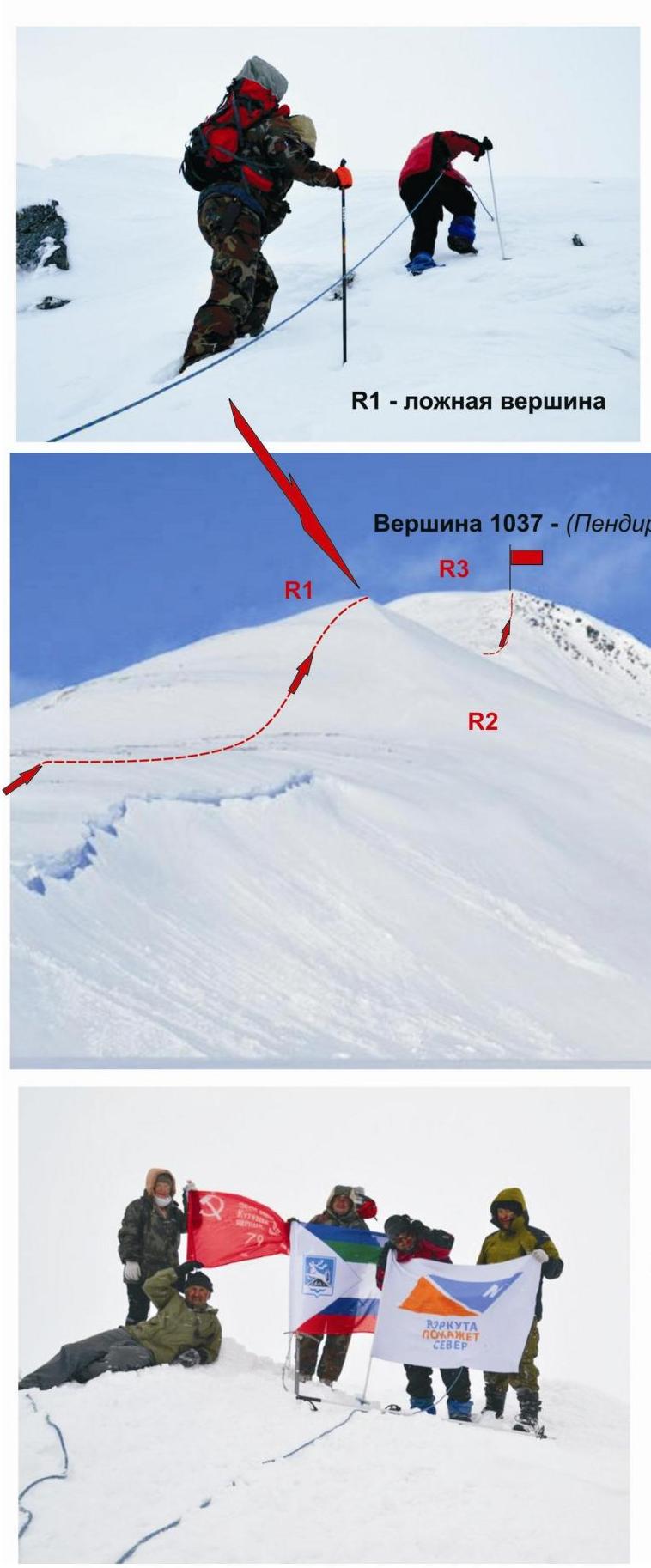
Northern part of the Polar Urals (Transpolar Urals). Peak: 1037 (Pendirmapé Eastern). Route: "via the Eastern ridge". Approximately: 1B cat. difficulty (winter). Sections:
- R1
- R2
- R3
Photo #1 — ascent to the false peak. Photo #2 — upper part of the Eastern ridge (profile). Photo #3 — group of first ascenders on the peak.
Participants of the first ascent. Leader: Seryakov S. V. (2nd sports category, Vorkuta).
Participants:
- Bakhvalova A. A. (3rd sports category, Vorkuta)
- Bochkа G. G. (3rd sports category, Vorkuta)
- Kabanov A. A. (3rd sports category, Vorkuta)
- Lakomy R. S. (3rd sports category, Vorkuta)
- Mayer V. L. (3rd sports category, Vorkuta)
- Tishchenko V. V. (3rd sports category, Vorkuta)
Description of the peak
Peak 1037 (Pendirmapé Eastern) — a thousand-meter peak of the Maly Paipudynsky mountain range in the Northern part of the Polar Urals ( Individual elevation of the Paipudynsky ridge) is separated from the nodal peak of the Paipudynsky ridge Pendirmapé (1221) and located in the Eastern ridge of the peak Pendirmapé on the territory of the Yamalo-Nenets National Okrug (YaNAO) of Tyumen Oblast (Ural Federal District of the Russian Federation). The height of peak 1037 is official, marked on the map-kilometer of the General Staff of the Russian Federation. The name is unofficial, determined by orographic features. Used for peak identification.
Description of the route
The route "via the Eastern ridge" is a characteristic training and educational combined route of 1B category of difficulty (snow-ice). It has a full range of snow-ice natural obstacles corresponding to routes of this level.
Passing this route has not only aesthetic but also educational and sports practical significance, as it allows to practice techniques within the ascent:
- belaying
- self-belaying on snowy relief
The route is logical, long-lasting, requiring preliminary preparation.
Equipment
For the ascent as part of a training and sports group of 6 people (5 participants + instructor) on the route, the following special equipment is required:
Personal (standard, including):
- crampons
- ice axe
- avalanche cord (beeper)
Group:
- main rope 10 mm — 3×50 m
- avalanche shovel — 2 pcs.
Approach
The ascent is made from the "Mezhdurechye streams Medvezhiy and Pryamoy" bivouac.
Approach to the bivouac:
- Approach is made on skis (snowshoes are allowed).
- From the "110 km" halt (former settlement Polyarný) follow the snowy dirt road to the destroyed bridge over the Malaya Paipudyna river.
- Then, along the right bank of the river, ascend to the upper reaches of the Malaya Paipudyna river.
- After crossing the Medvezhiy stream (open water is possible) on the high left bank, there are convenient places for organizing a bivouac.
It should be noted that:
- The "Mezhdurechye streams Medvezhiy and Pryamoy" bivouac is located in the tundra zone, gas burners are necessary.
- Telephone communication is not available.
- Communication via VHF radio stations is problematic.
Time of approach:
- From the "110 km" halt to the bivouac takes 3–4 hours.
- From the "Mezhdurechye streams Medvezhiy and Pryamoy" bivouac to the start of the route — one and a half to two hours.
Technical part
The start of the route is a snowy slope of the Eastern ridge. There is a convenient place for organizing a link — a wind-protected sub-rock niche. Crampons on the route are mandatory! In May, the crust is as dense as multi-year firn.
The slope is potentially avalanche-prone, especially with fresh snowfall, so it is recommended to ascend the slope "head-on" to the false peak. From the false peak, follow the Eastern ridge. The ridge is wide. Ascend along the ridge to the base of the summit couloir of peak 1037 (Pendirmapé Eastern). Then ascend to the peak.
The route is equivalent in difficulty, there is no pronounced key section.
Peak 1037 (Pendirmapé Eastern) — a pronounced rock outcrop 10–15 m high. Cairn under the rock outcrop.
Descent. Descent from the peak is made via the ascent route.
APPROACH: From the base camp to the base of the Eastern ridge — 1.5–2 hours.
Section R0–R1. Ascent to the Eastern ridge, to the false peak. Snowy slope.
- Length — 1100 m
- Steepness — up to 45°
- Level of difficulty — 1+–2− cat. difficulty
- Movement — simultaneous with mutual belaying, in links
- Number of pitons used/left: 0/0 pcs, 0/0 pcs
Section R1–R2. Passage of the Eastern ridge under the summit dome. Snow, dense crust, dense rime. Cornices. (Subjective avalanche danger!)
- Length — 300 m
- Steepness — 20°
- Level of difficulty — 1 cat. difficulty
- Movement — simultaneous, in links with mutual belaying
- Number of pitons used/left: 0/0 pcs, 0/0 pcs
Section R2–R3. Ascent to the summit dome and rock outcrop — the peak. Snow, dense crust, rime "Sugar head". In the upper part — snowy rocks.
- Length — 250 m (rock outcrop — 15 m)
- Steepness — 45°
- Level of difficulty — 2 cat. difficulty
- Movement — with alternate belaying, interaction of links
- Number of pitons used/left: 0/0 pcs, 0/0 pcs
R3-peak: Rock outcrop 10–15 m high. No convenient platform, cairn at the base of the outcrop.
DESCENT: Via the ascent route.
Northern part of the Polar Urals (Transpolar Urals). Maly Paipudynsky ridge. Southeast circus. Peak: 1037 (Pendirmapé Eastern). Route: "via the Eastern ridge". 1B (winter) (approximately) (table of natural obstacles on the route)
| Section | Length | Steepness | Character of relief | Cat. difficulty | Number of pitons/chocks |
|---|---|---|---|---|---|
| APPROACH | From the base camp in the interfluve of the Medvezhiy and Pryamoy streams about four kilometers and takes 1.5 hours through mountain tundra and snowy slopes. On skis (snowshoes). | ||||
| R0 — Base of the Eastern ridge | Convenient place for organizing links in a niche under a rock. | ||||
| R0–R1. Ascent along the Eastern slope to the exit to the pre-summit ridge | 1100 | up to 45 | Snowy slope. (Avalanche danger! Movement only "head-on") | 2- | 0 / 0 |
| R1–R2. Passage of the Eastern pre-summit ridge | 300 | 20 | Snowy ridge | 1 | 0 / 0 |
| R2–R3. Ascent to the summit dome and rock outcrop of the peak | 250 15 | up to 45 | Snowy slope. Destroyed, snowy rocky ridge | 2- 1 | 0 / 0 |
| R3 — peak 1037 (Pendirmapé Eastern). | Clearly expressed — by a rock outcrop 10–15 meters high. Under the rock outcrop. | ||||
| DESCENT | Via the Eastern ridge (via the ascent route). |
Summary
Length of the route — 1655 m. Average steepness — 30°. Character of relief — snow-ice. Technical sections:
- 1 cat. difficulty — 2 sections — 315 m
- 2 cat. difficulty — 2 sections — 1350 m
Number of pitons and chocks used: 0/0 pcs. Number of pitons and chocks left: 0/0 pcs.
APPROACH AND BASE CAMP
Approach to the base camp in the interfluve of the Medvezhiy and Pryamoy streams from the "110 km" halt (former settlement Polyarný) — 3–4 hours on skis (snowshoes).
Northern part of the Polar Urals (Transpolar Urals). Maly Paipudynsky ridge. Southeast circus. Peak: 1037 (Pendirmapé Eastern). Route: "via the Eastern ridge". Approximately: 1B cat. difficulty (Winter). Photo of the Eastern ridge with the ascent route marked.
APPROACH: From the base camp to the base of the Eastern ridge — 1.5–2 hours.
Section R0–R1. Ascent to the Eastern ridge, to the false peak. Snowy slope.
- Length — 1100 m
- Steepness — up to 45°
- Level of difficulty — 1+–2− cat. difficulty
Movement is simultaneous with mutual belaying, in links. Number of pitons used/left: 0/0 pcs, 0/0 pcs.
Section R1–R2. Passage of the Eastern ridge under the summit dome.
- Snow, dense crust, dense rime
- Cornices
- (Subjective avalanche danger!)
Length — 300 m. Steepness — 20°. Level of difficulty — 1B cat. difficulty. Movement is simultaneous, in links with mutual belaying. Number of pitons used/left: 0/0 pcs, 0/0 pcs.
Section R2–R3. Ascent to the summit dome and rock outcrop — the peak. Snow, dense crust, drifts "Sugar head". In the upper part — snowy rocks.
Length — 250 m (rock outcrop — 15 meters). Steepness — 45°. Cat. difficulty — 2B.
Movement with alternate belaying, interaction of links.
Number of pitons used/left: 0/0 pcs, 0/0 pcs.
R3 — peak: rock outcrop 10–15 m high. No convenient platform, cairn at the base of the outcrop.
DESCENT: Via the ascent route. Start of the route — niche under a rock in the lower part of the Eastern slope of the Eastern ridge — R0 (place of organizing links)