Ascent Passport
Region – Subpolar Urals. Ridge – Narod-Ityinsky Ridge (kряж). Gorge – Bolshaya Lemva River Valley. Mountain massif – Parnokaiz. Section number according to KMGV-2001 – №8. "Other mountain systems, massifs". Name of the peak – 1194.7 (Parnokaiz Glavny). Height – 1194.7 m. Route name – via the central couloir of the southern slope and the southeastern ridge.
First Ascent
Recommended category of complexity for inclusion in the KMGV of the Russian Mountaineering Federation – 1B cat. (rocky).
Note: The Mountaineering Federation of the Komi Republic requests the classification commission of the FAR to certify the first ascenders' climb as 2A cat.
Height difference – 700 m. Route length – 12 km. Average steepness of the main (technical) part of the route – 35°. Average steepness of the entire route – 20°. Sections of 3, 4, 5, and 6 cat. – none. No pitons left on the route. Time taken by the team for the ascent:
- Approach to the base camp (conserved geologists' base "Lemva") from the miners' settlement Pachvoz – 2 days.
- Ascent from the base camp (conserved geologists' base) – 8 hours.
Leader, commander of NP-2: S. Zhuravlev, CMS, instructor 2 cat., cert. № 1124. Participants:
- Kustov P. A. ("Mountaineer of Russia" badge, Syktyvkar)
- Punanova A. A. ("Mountaineer of Russia" badge, Syktyvkar)
- Druzhnin E. V. ("Mountaineer of Russia" badge, Syktyvkar)
- Repina S. A. ("Mountaineer of Russia" badge, Syktyvkar)
- Chernetsova M. V. ("Mountaineer of Russia" badge, Syktyvkar)
- Klementiev D. N. ("Mountaineer of Russia" badge, Syktyvkar)
- Koldanova T. M. ("Mountaineer of Russia" badge, Syktyvkar)
- Bobretsov K. L. ("Mountaineer of Russia" badge, Ukhta)
Coach – Zhuravlev Sergey Vasilyevich (CMS, instructor 2 cat., cert. №1124, Syktyvkar).
Senior coach-supervisor – Fomenko Felix Nikolayevich (CMS, instructor 1 cat., cert. №7, Ukhta).
Departure for the route – 6:00, August 14, 2005. Reaching the summit – 15:30, August 14, 2005. Return to base camp – 19:00, August 14, 2005.
Mountaineering event: Monitoring expedition of the Mountaineering Federation of the Komi Republic "Lemva-2005".
Organizers of the mountaineering event: Mountaineering Federation of the Komi Republic, Tourist and Mountaineering Club of Ukhta.
 View of peak 1194.7 (Parnokaiz Glavny) with peak 1152 (Pernaiz)
 View of the Parnoksky massif from peak 1152 (Pernaiz)
Mountaineering Federation of the Komi Republic
NP "Sauk-Pai Northern Travel Club" Tourist and Mountaineering Club of Ukhta
Report
on the first ascent
Mountain region: Subpolar Urals Gorge: Bolshaya Lemva River Valley Ridge: Narod-Ityinsky Ridge (kряж) Mountain massif: Parnokaiz Peak: 1194.7 (Parnokaiz Glavny) Route:
- via the central couloir of the southern slope
- via the southeastern ridge
Recommended cat. for inclusion in the KMGV of the Russian Mountaineering Federation: 1B (rocky). (Certify the group that made the first ascent as a 2A cat. climb.).
Leader: Zhuravlev S. V. Date of ascent: August 14, 2005. Mountaineering event: Monitoring expedition "Lemva-2005" of the Mountaineering Federation of the Komi Republic.
Senior coach-supervisor
Mountaineering Federation of the Komi Republic:
- Fomenko F. N. (CMS, instructor 1 cat., cert. №7, Ukhta)
- Deputy for safety (chief rescue officer): Zhuravlev S. V. (CMS, instructor 2 cat., cert. №1124, badge №6190, Syktyvkar)
Report prepared by: leader Zhuravlev Sergey Vasilyevich. Address: 167000, Syktyvkar, Internatsionalnaya str., 97, apt. 12. Phone (8212) 24-24-91 (home), E-mail: Zhur58@Rambler.Ru
Syktyvkar, 2006.
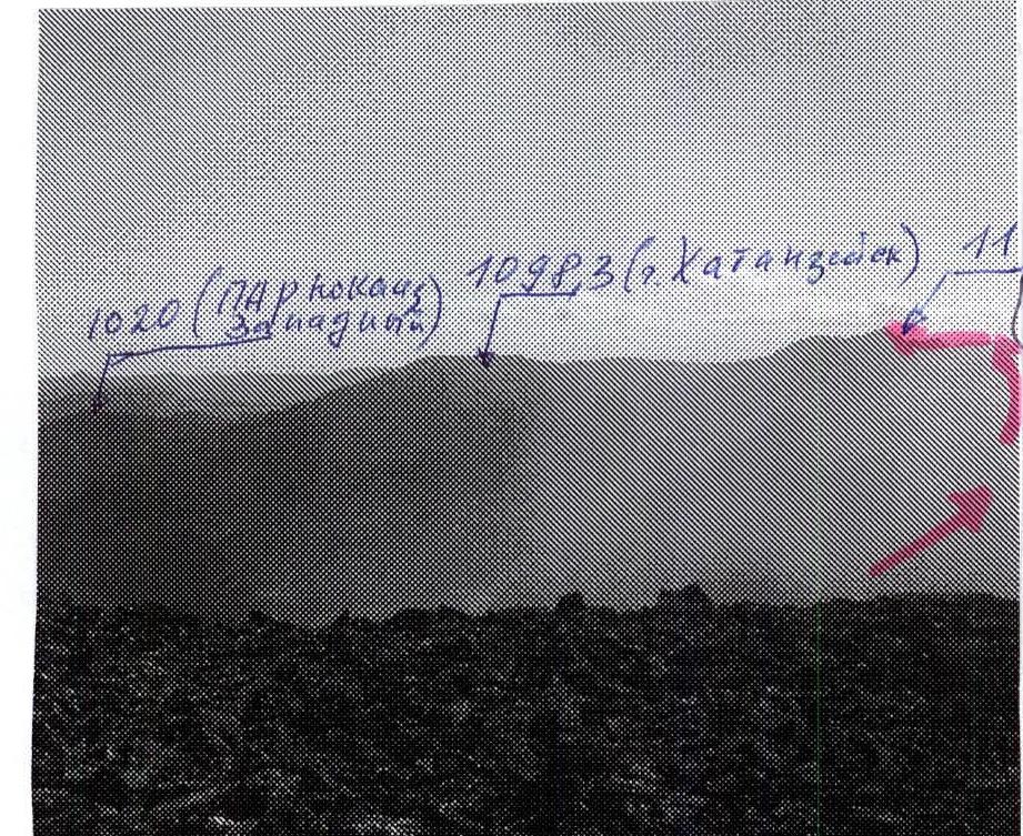
View of the Parnokaiz massif from peak Pernaiz:
- 1194.7 (Parnokaiz Glavny)
- 1098 (Mt. Khatanzeiskogo)
- 1020 (Parnokaiz Zapadny)
Description of the peak
Peak 1194.7 (Parnokaiz Glavny) is the main peak of the Parnokaiz mountain massif, which divides the valleys of the Bolshaya Lemva (to the southwest) and Parnokaiz (to the northeast) rivers, located in the center of the Parnoksky plateau and is the highest peak of the massif. It has its own geodetic height mark on the map of the Subpolar Urals – 1194.7 m above sea level. The entire Parnokaiz mountain massif stands west of the Main watershed ridge of the Subpolar Urals (section from peak Lemvaiz to peak Khaymaiz). This is a heavily destroyed mountain massif with an extensive plateau and a number of independent peaks located in various parts of it. The peak does not have its own name, as it is located in the center of a large pre-summit plateau and is weakly expressed from the valley.
Route description
Approach: The start of the route to peak 1194.7 (Parnokaiz Glavny) via the couloir of the southern slope from the Bolshaya Lemva River Valley (1B cat.) is conveniently made from the base camp in the upper reaches of the Bolshaya Lemva River (conserved geologists' base "Lemva"). From the base, go downstream along the dirt road, then cross the Pernashor stream, and reach the mouth of the unnamed stream. Along the valley, on the left bank of the stream (right as you go), ascend to the rocky canyon. Above the rocky canyon, cross the stream along large stones, then ascend to the gorge of the right tributary of the unnamed stream. From this point, the technical part of the route begins. Technical part: Ascend along the stream valley, sticking to the left (right as you go) bank. In the lower part, the section is not difficult, in the middle part, the main difficulty is presented by the water-smoothed rocky outcrops – "sheep's foreheads". After a series of "sheep's foreheads", exit to a large-block talus in the narrowing part of the couloir. The rocky massif is composed of loose rocks and is heavily destroyed (Rockfall hazard!). Further ascent to the base of the wide internal angle – "Trough", leading under the strip of red rocks. The section "red rocks" is a strip of loose, heavily destroyed rocky rocks (Rockfall hazard!), representing a series of scree, oblique shelves, and inclined slabs, as well as small 5–8 m internal angles. After passing the strip of red rocks, it is necessary to exit to the saddle between peaks Pernaiz (to the east) and Mt. Khatanzeiskogo (to the west), both peaks being part of the Parnokaiz mountain massif, and the saddle – an exit to the summit plateau of the Parnokaiz mountain massif in its southern part. Further (left as you go) go along the summit plateau to the base of the scree dome of the peak. The dome is composed of large-block fragmentary material. The peak is well expressed. Cairn in the center.
Descent: Recommended via route 1B cat. along the eastern slope of peak (1190) Parnokaiz Vostochny. Descent along the ascent path is potentially rockfall-prone in summer and avalanche-prone in winter.
Equipment (for NP-1 group of 10 people):
- main rope – 3x50 pcs.
- carabiners – 5 pcs.
- rock hammer – 1 pc.
- rock pitons – 3 pcs.
- station loops – 3 pcs.
Time taken for the ascent (for NP-1 group of 10 people): 8–10 hours.
Schematic map of the peaks of the Parnokaiz mountain massif (not to scale)
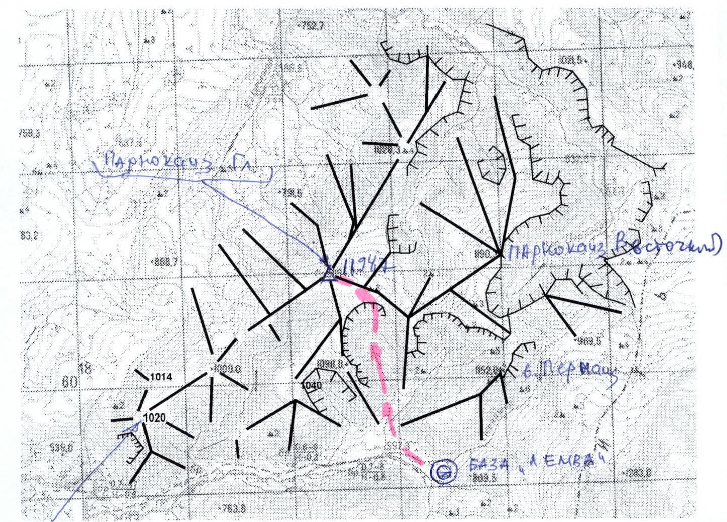 peak 1194.7 (Parnokaiz Glavny) route: via the central couloir of the southern slope and the southeastern ridge 1B cat. (rocky)
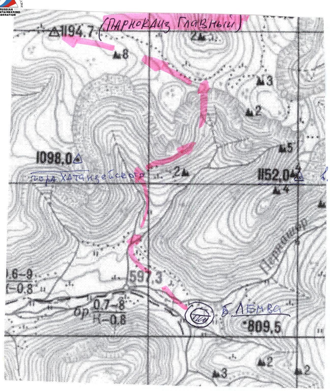 Schematic map of the ascent to peak Parnokaiz Glavny (approximately 1 cm – 500 m)
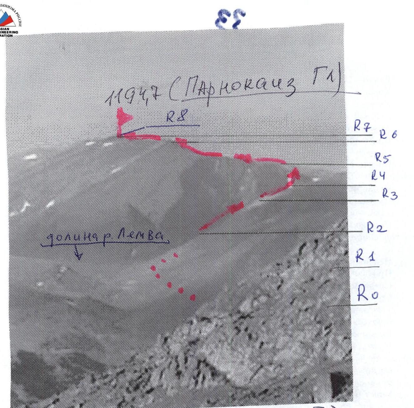
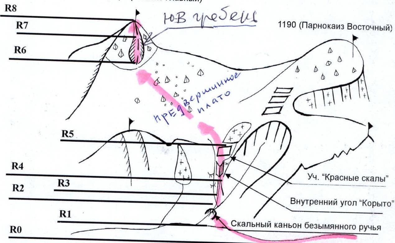 Scheme in UIAA signs and comments on sections
R0 – Bivouac in the upper reaches of the Bolshaya Lemva River. (conserved geologists' base "Lemva"). R0–R1 – Approach to the mouth of the stream, crossing Pernashor. Dirt road. Section length – 2000 m, non-categorized. R1–R2 – Traverse of rocky and scree slopes of Mt. Pernaiz. Section length – 1500 m. Slope steepness – 35–40°. Complexity level – 1 cat. R2–R3 – Exit to the rocky canyon. Scree, talus. Section length – 500 m. Slope steepness – 35–40°. Complexity level – 1 cat. R3–R4 – Passage through the scree, rocky couloir. Rocks, large-block scree. Section length – 1000 m. Steepness – 35°. Complexity level of the section – 1 cat. R4–R5 – Passage through the "Trough" – a wide internal angle (steepness 45–50°, in some areas 55–60°). And the section "red rocks". Rocks. Section length – 200 m. Steepness – complexity level – 1+, in some areas – 2 cat. R5–R6 – Traverse along the pre-summit plateau of the Parnokaiz mountain massif. Scree. Section length – 3000 m. Steepness – 15°. Complexity level of the section – non-categorized. R6–R7 – Ascent along the summit ridge. Heavily destroyed rocks. Section length – 600 m. Steepness – 45°. Complexity level of the section – 1 cat. R7–R8 – Exit to the summit scree dome. R8 – Peak 1194.7 "Parnokaiz Glavny". R8–R0 – Descent along the ascent path.
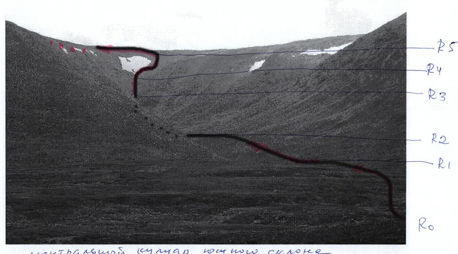 central couloir of the southern slope of the Parnoksky mountain massif