Ascent Passport
Region — Subpolar Urals. Ridge — Narod-Ityinsky Ridge. Valley — Bolshaya Lemva River Valley. Mountain range — Parnokaiz. Section number according to KMGV-2001 — #8. "Other mountain systems, ranges". Peak name — 1190.3 (Parnokaiz East). Height — 1190.3 m. Route name — via the eastern slope and southeastern ridge. First ascent. Proposed difficulty category — 1B (rocky). Note: The Climbing Federation of the Komi Republic requests the classification commission of the Russian Climbing Federation to credit the group with a 2A ascent.
Elevation gain — 597 meters. Route length — 10 km. Average steepness of the main (technical) part of the route — 35°. Average steepness of the entire route — 20°. Sections of 3, 4, 5, and 6 difficulty categories — none. No pitons were left on the route. Team time spent on the ascent:
- Approach to the base camp (conserved geologists' base "Lemva") from Pachvoz settlement — 2 days.
Ascent from the base camp — 6 hours.
Leader: S. Zhuravlev (Candidate for Master of Sports, instructor 2nd category — certificate #1124, Syktyvkar).
Team members:
- Gorokhova M. V. (3rd sports category, Syktyvkar)
- Kustov P. A. ("Alpinist of Russia" badge, Syktyvkar)
- Kondratieva N. D. (3rd sports category, Syktyvkar)
- Sivkov D. I. (3rd sports category, Syktyvkar)
- Punanova A. A. (3rd sports category, Syktyvkar)
- Savinov A. E. ("Alpinist of Russia" badge, Syktyvkar).
Coach — Zhuravlev Sergey Vasilyevich (Candidate for Master of Sports, instructor 2nd category — certificate #1124, Syktyvkar)
Senior coach — Fomenko Felix Nikolaevich (Candidate for Master of Sports, instructor 1st category — certificate #7, Ukhta)
Departure for the route — 8:00 August 11, 2005. Reaching the summit — 13:30 August 11, 2005. Return to base camp — 17:00 August 11, 2005.
Climbing event: Monitoring expedition of the Climbing Federation of the Komi Republic "Lemva-2005".
Organizers of the expedition: Climbing Federation of the Komi Republic, Club of Tourists and Climbers of Ukhta.
Climbing Federation of the Komi Republic NP "Sauk-Pai Northern Travel Club" Ukhta Climbers and Tourists Club
REPORT on the first ascent
Mountain region: Subpolar Urals
Valley: Bolshaya Lemva River Valley
Ridge: Narod-Ityinsky Ridge
Mountain range: Parnokaiz
Peak: 1190 (Parnokaiz East)
Route: via the eastern slope and southeastern ridge
Proposed difficulty category for inclusion in KMGV of the Russian Climbing Federation: 1B (rocky)
(Credit the group that made the first ascent with a 2A ascent.)
Leader: Zhuravlev Sergey Vasilyevich
Date of ascent: August 11, 2005.
Climbing event: Monitoring expedition "Lemva-2005" of the Climbing Federation of the Komi Republic.
Senior coach — Fomenko F. N. (Candidate for Master of Sports, instructor 1st category — certificate #7, Ukhta)
Deputy for safety — Zhuravlev S. V. (Candidate for Master of Sports, instructor 2nd category — certificate #1124, badge #6190)
Report prepared by: expedition leader Zhuravlev Sergey Vasilyevich
Address: 167000, Syktyvkar, Internatsionalnaya str., 97, apt. 12.
Contacts:
- Phone: (8212) 24-24-91 (home)
- E-mail: zhur58@rambler.ru
Syktyvkar, 2006
Description of the peak
Peak 1190 (Parnokaiz East) — the eastern peak of the Parnokaiz mountain range, dividing the valleys of the Bolshaya Lemva River (to the southwest) and the Parnokayu River (to the northeast). The range is located west of the Main Watershed Ridge of the Subpolar Urals (section from Lemvaiz peak to Khaymaiz peak). This is a heavily destroyed mountain range with a vast summit plateau and several independent peaks located in various parts of this plateau.
Peak 1190 (Parnokaiz East) — the most easterly peak, has characteristic signs of a peak, a geodetic height mark — 1190.3 m above sea level. A characteristic landmark is the cirque canyon of the Levaya Parnokayu River, bounding the entire Parnokayu mountain range from the east.
Description of the route
Approach: The start of the route to peak 1190 (Parnokaiz East) via the eastern slope from the Bolshaya Lemva River valley (1B category) is conveniently made from the base camp in the upper reaches of the Bolshaya Lemva River (conserved geologists' base "Lemva").
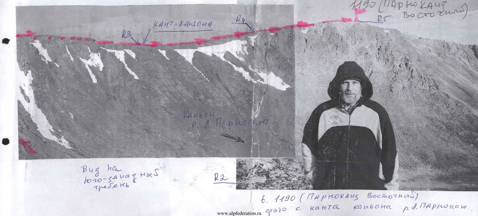
Technical part: Approach the Pernaozh stream valley and begin the ascent along its right bank (left bank in the direction of travel). Move upwards to the pass leading through the Main Watershed Ridge of the Subpolar Urals into the Grubeyu River valley. Before reaching the upper point of the pass, turn left and, traversing the scree slope, ascend to the eastern slope of peak 1190 (Parnokaiz East). Ascend along the scree slope to the boundary of the cirque canyon of the Levaya Parnokayu River. Then follow the ridge along the boundary of the cirque canyon. (In good weather, peak 1190 (Parnokaiz East) is visible from the ridge.)
Ascend along the rocky, heavily destroyed ridge to the saddle between peaks Pernaiz and Parnokaiz East. This saddle is the eastern exit to the plateau of the Parnokaiz mountain range. Then proceed along the summit plateau (to the right in the direction of travel), following the boundary of the cirque canyon of the Levaya Parnokayu River, to the base of the summit scree dome of Parnokaiz East.
The base — simple but lengthy slab-like rocks resembling giant steps. ("Steps" section).
Movement along the section:
- Approach the scree dome along the rocky steps.
- The dome is composed of large-block fragmentary material.
- Ascend to the summit along the screes.
As the peak is plateau-like, determining the highest point is challenging. The cairn is tall, constructed from slab-schists.
Descent: Follow the ascent route. Equipment (for a group of 10 people):
- main rope — 3x50 m
- carabiners — 5 pcs.
- rock hammer — 1 pc.
- rock pitons — 3 pcs.
- station loops — 3 pcs.
Time required for the ascent (for a group of 10 people): 8–10 hours.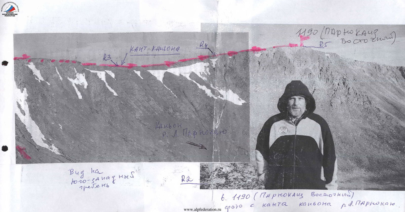
 Scheme in UIAA signs. Peak: 1190 (Parnokaiz East). Route: via the eastern slope and southeastern ridge
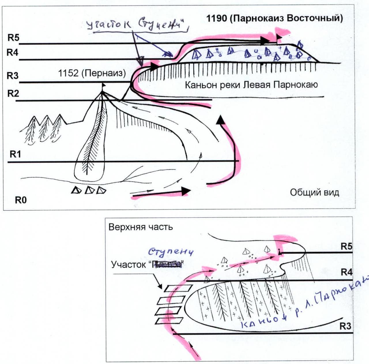
R0 — Base camp (conserved geologists' base "Lemva")
R0–R1 — ascent to the pass along the scree slopes of the Pernaozh stream valley.
- Section length — 2000 meters
- Average steepness of the section — 15–20°
- Difficulty level — non-categorized.
R1–R2 — traverse of the eastern slope and exit to the heavily destroyed rocky ridge bounding the canyon of the Levaya Parnokayu River on the left (in the direction of travel).
- Canyon edges are steep, rocky, and scree-covered
- Alternating with snowy couloirs.
Rocky-scree slope. Section length — 1000 meters, average steepness — 20°, difficulty level — 1. Until July 15, the ridge is snowy. In winter, there are snow drifts and overhanging cornices towards the canyon.
R2–R3 — heavily destroyed rocky ridge. Rocky ridge. Section length — 500 meters. Average steepness — 15–20°. Difficulty level — 1-, 1+.
R3–R4 — "Steps" section — a series of wide, inclined step-like rocky slabs.
Rocky outcrops.
- Section length — 350 meters
- Steepness — 30°
- Difficulty level — 1+.
R4–R5 — exit to the summit plateau and the summit scree dome. Large-block and medium-block scree.
- Section length — 1000 meters
- Steepness — 10°
- Difficulty level — non-categorized.
R5 — peak 1190 (Parnokaiz East)
R5–R0 — descent from the peak to the base camp along the ascent route.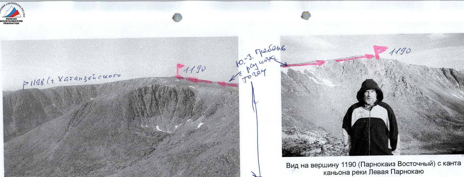
View of peak 1190 (Parnokaiz East) from the edge of the Levaya Parnokayu River canyon
Peak 1190 (Parnokaiz East) View from peak 1152 (Pernaiz)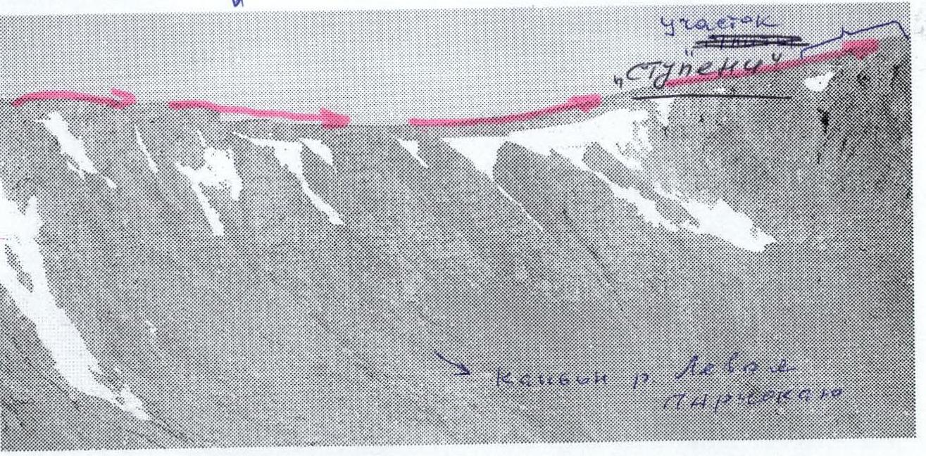
Edge of the rocky canyon of the Levaya Parnokayu River
PARNOKAIZ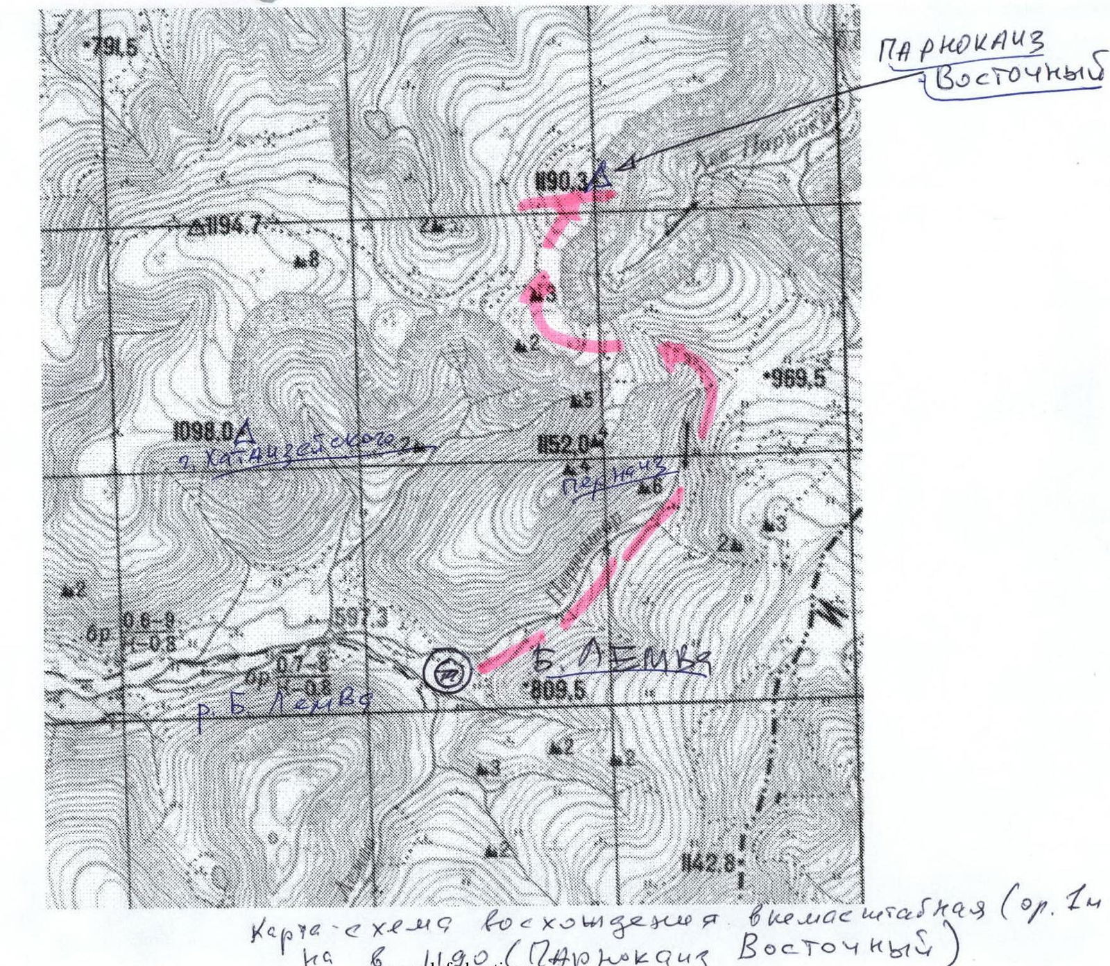 Scale-less ascent scheme (or. 1:500 m) to peak 1190 (Parnokaiz East)