Ascent Passport
- Region: Subpolar Urals
- Ridge: Narod-Ityinsky Ridge (krai)
- Valley: Bolshaya Lemva River Valley
- Section number according to KMGV-2001: #8 "Other mountain systems, massifs"
- Peak name: Parnokaiz East
- Height: 1190.3 m
- Route name: via the central couloir of the southern slope and southwestern slope
First Ascent
Proposed category of complexity - 1B cat. (rocky)
Note: The Alpinism Federation of the Komi Republic requests the classification committee of the FAR to credit the group of pioneers with the ascent of 2A cat.
Height difference - 597 m. Route length - 12 km. Average steepness of the main (technical) part of the route - 55°. Average steepness of the entire route - 30°. No pitons were left on the route. Time taken by the team for the ascent:
- Approach to the base camp (mothballed geologists' base) from Pachvoz settlement - 2 days.
Ascent from the base camp (mothballed geologists' base) - 6 hours. Leader: S. Zhuravlev (CMS, instr. 2 cat. - cert. #1124, Syktyvkar). Participants:
- Gorokhova O. N. (2nd sports category, Syktyvkar)
- Kustov P. V. ("Alpinist of Russia" badge, Syktyvkar)
- Dmitrieva N. D. (3rd sports category, Syktyvkar)
- Sivkov D. A. ("Alpinist of Russia" badge, Syktyvkar)
- Punanova A. A. ("Alpinist of Russia" badge, Syktyvkar)
Coach - Zhuravlev Sergey Vasilyevich (CMS, instr. 2 cat. - cert. #1124, Syktyvkar).
Senior coach-supervisor - Fomenko Felix Nikolayevich (CMS, instr. 1 cat. - cert. #7, Ukhta).
Departure on the route - 8:00, August 10, 2005. Reached the summit - 14:15, August 10, 2005. Return to base camp - 16:00, August 10, 2005.
Alpinist event: Monitoring expedition of the Alpinism Federation of the Komi Republic "Lemva-2005".
Expedition organizers:
- Alpinism Federation of the Komi Republic
- Tourist and Alpinist Club of Ukhta
Alpinism Federation of the Komi Republic, NP "Sauk-Pai North Travel Club", Tourist and Alpinist Club of Ukhta
Report on the First Ascent
- Mountain region: Subpolar Urals
- Valley: Bolshaya Lemva River Valley
- Ridge: Narod-Ityinsky Ridge (krai)
- Mountain massif: Parnokaiz
- Peak: 1190 (Parnokaiz East)
- Route: via the central couloir of the southern slope and southwestern ridge
Proposed category of complexity for inclusion in the KMGV of the Alpinism Federation of Russia: 1B cat. (rocky) (Credit the group that made the first ascent as a 2A cat. ascent)
Leader: Zhuravlev S. V. Date of ascent: August 10, 2005. Alpinist event: Monitoring expedition "Lemva-2005" of the Alpinism Federation of the Komi Republic.
Senior coach-supervisor of the Alpinism Federation of the Komi Republic
Fomenko F. N. (CMS, 1 cat. - cert. #7, Ukhta)
Deputy for safety (chief rescue officer) of the Alpinism Federation of the Komi Republic
Zhuravlev S. V. (CMS, instr. 2 cat. - cert. #1124, badge #6190, Syktyvkar)
Report prepared by: expedition leader - Zhuravlev Sergey Vasilyevich Address: 167000, Syktyvkar, Internatsionalnaya st., 97, apt. 12. Contacts:
- phone (8212) 24-24-91 (home)
- E-mail: Zhur58@Rambler.Ru
Syktyvkar, 2006
Description of the Peak
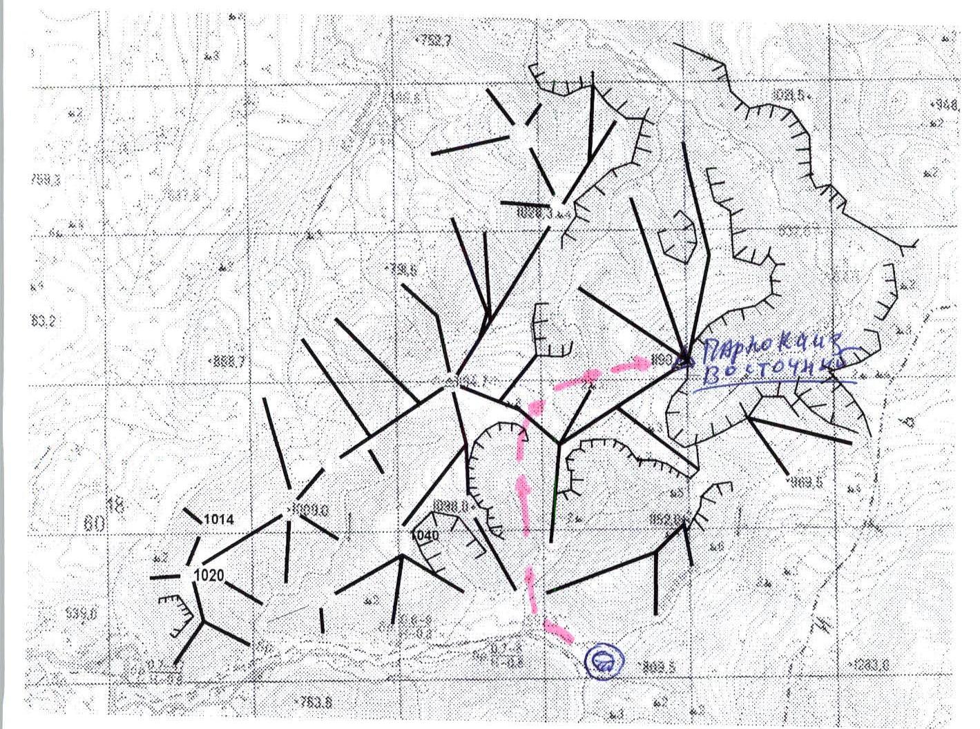
Peak 1190 (Parnokaiz East) - the eastern peak of the Parnokaiz mountain massif, which divides the valleys of the Bolshaya Lemva River (to the southwest) and the Parnokayu River (to the northeast). The Parnokaiz massif is located west of the Main Watershed Ridge of the Subpolar Urals (section from Lemvaiz peak to Khaymaiz peak). This is a heavily destroyed mountain massif with an extensive summit plateau and several independent peaks located in various parts of the summit plateau.
Peak 1190 (Parnokaiz East) is the most easterly. It has characteristic signs of a peak, a geodetic height mark on the map of 1190.3 m above sea level. A characteristic landmark is the cirque canyon of the Levyy Parnokayu River, which bounds the entire Parnoksky mountain massif to the east.
Description of the Route
Approach: The ascent on the route via the central couloir of the southern slope and southwestern ridge to peak 1190 (Parnokaiz East) from the Bolshaya Lemva River valley (1B cat.) can be conveniently started from the base camp in the upper reaches of the Bolshaya Lemva River (mothballed geologists' base "Lemva").
Go down the Bolshaya Lemva River along the all-terrain road, then cross the Pernashor stream and reach the mouth of the unnamed stream. Then, along the valley, on the left bank of this stream, ascend to the rocky canyon. Above the rocky canyon, cross the stream over large stones and ascend into the gorge of the right tributary of the unnamed stream, which flows from the permanent snowfield on the summit plateau of the Parnoksky mountain massif along a well-defined couloir. From this point, the technical part of the route begins.
Technical part: Ascend along the stream valley and enter the wide part of the couloir, keeping to the left (right as you move) bank of the stream. In the lower part, the section is not difficult; in the middle part, the main difficulty is the water-smoothed rocky outcrops - "ram's foreheads". Having passed a series of "ram's foreheads", there is an exit to a large-block talus to the base of a wide internal corner - "Trough", leading under a strip of red rocks, to the saddle between peaks 1152 (Pernaiiz) and 1098 (Khatanzeiskogo mountain). Both named peaks are part of the Parnokaiz mountain massif, and the saddle is the southern exit to the Parnokaiz summit plateau. Then along the plateau (to the right as you move) approach the base of the talus dome of the peak. The base is not difficult, but lengthy, slab-like rocks resembling giant steps. (Section "Steps"). Along the steps, approach the talus dome. The dome is composed of large-block fragmentary material. Ascend the talus to the peak. Since the peak is plateau-like, it is difficult to determine the highest point. The cairn is high, built from slab-schists.
Descent: Via the ascent route. Equipment (for a group of 10 people, NP-1): main rope - 3 × 50 m, carabiners - 5 pcs., rock hammer - 1 pc., rock pitons - 3 pcs., station loops - 3 pcs. Time taken for the ascent (for a group of 10 people, NP-1): 8-10 hours.
Schematic map of the peaks of the Parnokaiz mountain massif (out of scale)
UIAA sign scheme
Peak: 1190 (Parnokaiz East) Route: via the central couloir of the southern slope and southwestern ridge
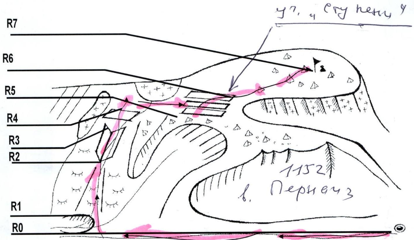
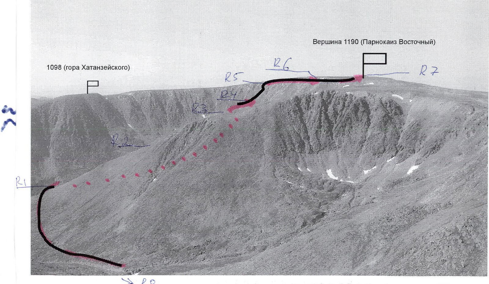
R0 - Base camp (Mothballed geologists' base "Lemva"). R0-R1 - Crossing the Pernashor stream and approach to the rocky canyon of the unnamed stream.
All-terrain road, stony tundra, traverse of the western slopes of Pernaiiz peak. Section length - 1000 m. Steepness 15-20°. Level of complexity - non-categorized. In some areas - 1.
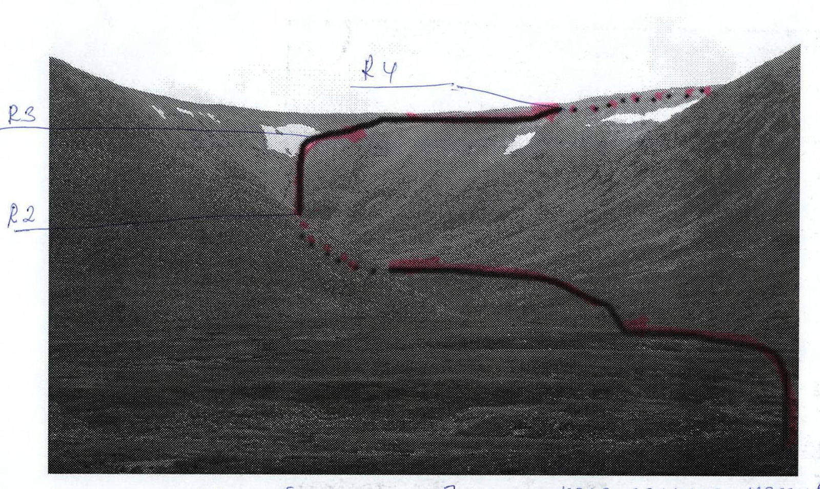
R1-R2 - Ascent along the couloir. Large-block talus. Ram's foreheads. Small internal corners. Section length - 1500 m. Steepness - 45°. Level of complexity - 1, 1+.
R2-R3 - Passage through the internal corner "Trough". Heavily destroyed rocks, rock ledges. Section length - 300 m. Steepness - 45°, in some areas 3-4 m high - 50°. Level of complexity - 1+, in some areas 3-4 m high - 1+, 2. Movement on a shortened rope. Insurance for large, separate blocks.
R3-R4 - Passage through the "Red rocks" section. Heavily destroyed rocks. Oblique and inclined ledges, inclined walls. Steepness - 45°. Level of complexity - 1+. Movement on a shortened rope. Insurance for large, separate blocks.
R4-R5 - Passage along the summit plateau to the base of the rocky-talus dome of peak 1190 (Parnokaiz East). Mountain tundra, kurumniks. (Until June 25 - snow). Section length - 2000 m. Steepness - 10-15°. Level of complexity - non-categorized.
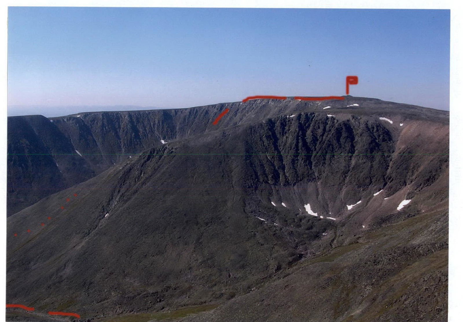
R5-R6 - Passage through the "Steps" section. Heavily destroyed rocks. Lengthy oblique inclined ledges. Section length - 350 m. Steepness - 30°. Level of complexity - 1, 1+. Movement on a shortened rope. Insurance for large, separate blocks.
R6-R7 - Ascent to the rocky-talus dome and exit to the summit. Large-block and medium-block talus. (Until June 25 - snow). Steepness - 10°. Level of complexity - non-categorized.
R7 - Peak 1190 (Parnokaiz East). R7-R0 - Descent to the base camp.
Recommended descent via route 1B cat. - along the eastern slope and southeastern ridge. This route is less stony on the descent.
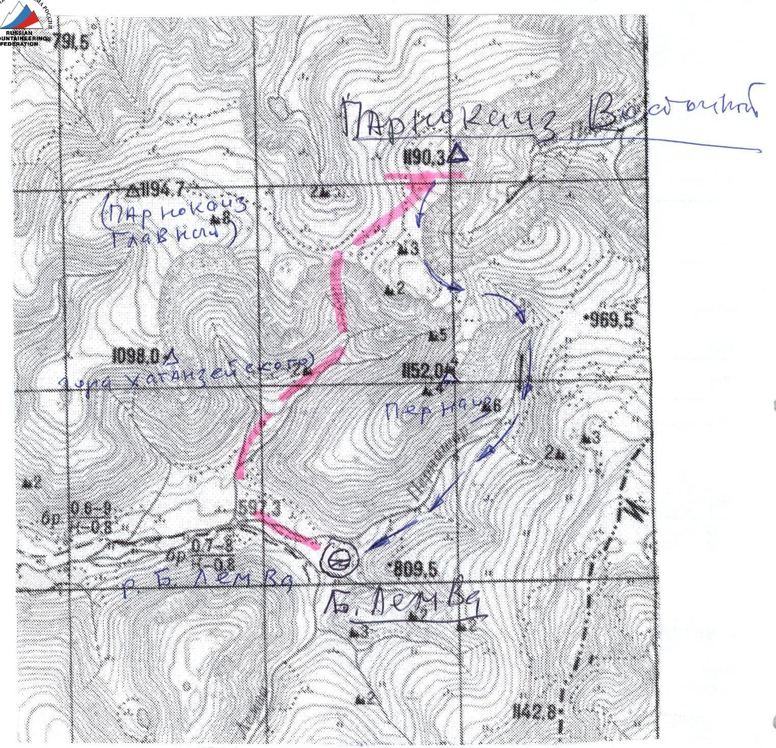
Schematic map of approaches (out of scale)
Approximately 1 cm - 500 m. — descent path (along the Eastern ridge)