Ascent Passport
Region — Subpolar Urals. Ridge — Narod-Ityin Ridge. Valley — Bolshaya Lemva River Valley. Mountain massif: main watershed ridge of the Subpolar Urals (section: Lemvaiz peak – Khaimaiz peak).
Section number according to KMGV-2001 — #8. "Other mountain systems, massifs", Peak name — 1345 (Oplesnina mountain) Elevation — 1345 m Route name — via the sixth spur of the western slope First ascent Proposed category of difficulty — 2A cat. diff. (rocky)
Note: The Alpinism Federation of the Komi Republic requests the Classification Commission of the FAR to certify the ascent as 2B cat. diff. for the group of pioneers.
Elevation gain — 648 m. Route length: 8 km. Average steepness of the main (technical part) of the route — 65°. Average steepness of the entire route — 45°. Technically difficult sections:
- sections of 3 cat. diff. — 1
- sections of 4, 5, 6 cat. diff. — none.
No pitons were left on the route. Time spent by the team on the ascent:
- Approach to the base camp (conserved geologists' base "Lemva") from Pachvoz settlement — 2 days.
Ascent from the base camp (conserved geologists' base) — 10 hours. Leader: Zhuravlev S. V. (CMS, instr. 2 cat. — cert. #1124, Syktyvkar). Participants:
- Bondaruk P. P. (3rd sports category, Syktyvkar)
- Druzhinin E. V. (3rd sports category, Syktyvkar)
- Punanova A. A. (3rd sports category, Syktyvkar)
Coach — Zhuravlev Sergey Vasilyevich (CMS, instr. 2 cat. — cert. #1124, Syktyvkar).
Senior coach — Fomenko Felix Nikolayevich (CMS, instr. 1 cat. — cert. #7, Ukhta).
Departure for the route — 6:00, August 14, 2006. Reaching the summit — 15:15, August 14, 2006. Return to the base camp — 18:00, August 14, 2006.
Alpinism event: Volunteer Youth Alpinism Scientific-Sports Expedition "Heights of the Native Land-2006", dedicated to the 85th anniversary of the Komi Republic statehood.
Expedition organizers:
- Alpinism Federation of the Komi Republic
- NP "Sauk-Pai North Travel Club"
- Ukhta Club of Tourists and Alpinists.
Alpinism Federation of the Komi Republic, NP "Sauk-Pai North Travel Club", Ukhta Club of Tourists and Alpinists
Report on the First Ascent
Mountain region: Subpolar Urals. Valley: Bolshaya Lemva River Valley. Ridge: Narod-Ityin Ridge. Mountain massif: main watershed ridge of the Subpolar Urals (section: Lemvaiz peak – Khaimaiz peak).
Peak: 1345 (Oplesnina mountain). Route: via the sixth spur of the western slope. Proposed category of difficulty for inclusion in the KMGV of the Alpinism Federation of Russia: 2A (rocky). (The group that made the first ascent is proposed to be certified for 2B cat. diff.).
Leader — instr. dept. SP: Zhuravlev Sergey Vasilyevich. Date of the ascent: August 14, 2006. Alpinism event: Volunteer Youth Scientific-Sports Alpinism Expedition "Heights of the Native Land-2006", dedicated to the 85th anniversary of the Komi Republic statehood.
Senior coach — Fomenko F. N. (CMS, instr. 1 cat. — cert. #7, Ukhta).
Deputy for safety (head of rescue) of the Alpinism Federation of the Komi Republic — Zhuravlev S. V. (CMS, instr. 2 cat. — cert. #1124, badge — #6190, Syktyvkar).
Report prepared by: expedition leader: Zhuravlev Sergey Vasilyevich.
Address: 167000, Syktyvkar, Internatsionalnaya st., 97, apt. 12. Phone (8212) 24-24-91 (home), E-mail: Zhur58@Rambler.ru
 Sixth spur on 1345 (Oplesnina mountain). Route 2A cat. diff. (rocky).
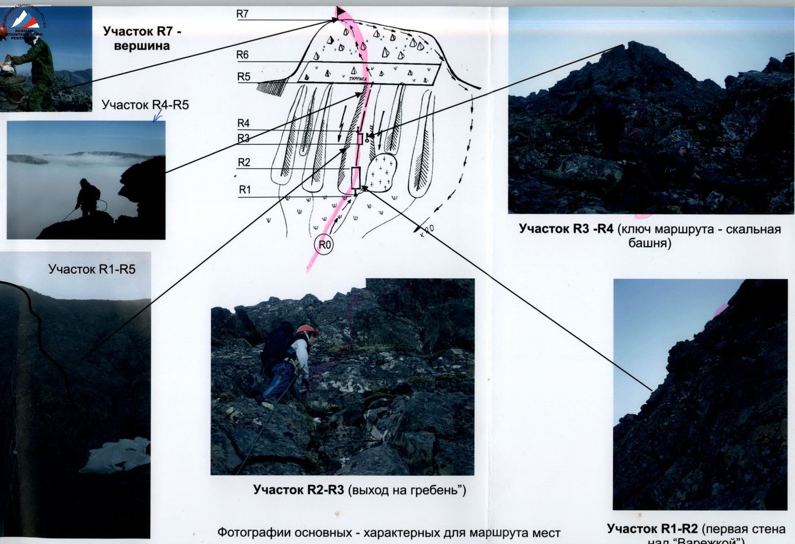 Section R1–R5
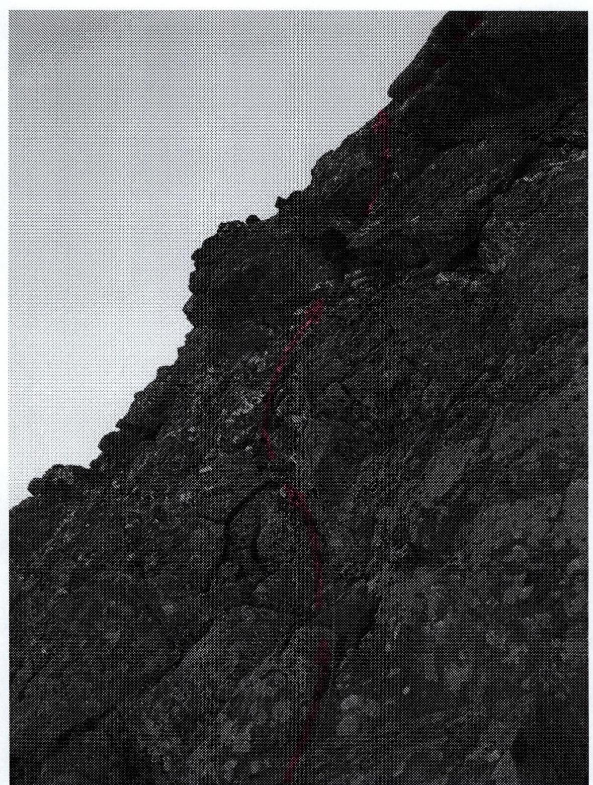
 Section R2–R3 (exit to the ridge)
Photographs of main — characteristic places of the route. www.alp-federation.ru↗
Section R1–R2 (first wall above "Varezhka").
Description of the Peak
Peak 1345 (Oplesnina mountain) is located on the section between Lemvaiz peak (to the south) and Khaimaiz peak (to the north) of the Main Watershed — Narod-Ityin Ridge (range) of the Subpolar Urals, which divides the valleys of the rivers:
- Lemva (south, southwest),
- Parnokayu (north, northwest),
- Tykotkova (east, northeast),
- Petrashor (northeast).
The main watershed ridge of the Subpolar Urals (on the section Lemvaiz peak – Khaimaiz peak) is a heavily destroyed mountain massif, dividing Europe and Asia, breaking off to the west with numerous rocky spurs of cirque type, and to the east (to Siberia) with prolonged scree slopes.
Peak 1345 (Oplesnina mountain) is located in the central part of this section. It is an extended ridge massif, stretched from south to north. The western slopes are rocky outcrops of cirque type in the form of a series of spurs, close to each other in length and steepness. The summit dome is composed of large fragmental material.
The name of the peak is not on the map. Obkomi reindeer herders from the village of Saranpaul, who occasionally graze herds in the Bolshaya Lemva River valley, do not have a local independent name for this peak. The name Peak 1345 — Oplesnina mountain was given by the participants of the youth volunteer expedition who made the first ascent, for ease of orientation.
Description of the Route
Approaches: from the bivouac in the upper reaches of the Bolshaya Lemva River (conserved geologists' base "Lemva": 3 barracks + bathhouse) go up the Bolshaya Lemva River valley to the mouth of a nameless stream flowing into Bolshaya Lemva on the right (10 min). Cross the stream, ascend along it on the left bank under the rocky cirque western slope of Peak 1345 (Oplesnina mountain). The sixth spur is characterized by a well-defined constant snowpatch "Varezhka" to the right (along the route) of the spur.
Technical part of the route: The route to Peak 1345 (Oplesnina mountain) via the sixth spur of the western slope is laid along a logical, easily identifiable spur of cirque type. On the rocky platform under the spur — a cairn marking the start of the route. On this rocky ledge-platform, it is convenient to organize rope teams. The route begins with a 60-meter inclined rocky wall with good holds, ledges for climbing, and fractures and cracks for organizing belays. Climb the wall to the left along the route to reach the rocky ridge of the spur. Then, along the ridge, approach the rocky wall of the second shoulder of the spur. This is the key point of the route. In the upper part, there are 10 meters of rocks of 3rd cat. diff. Further along the jagged rocky ridge, pass onto a terrace crossing the entire massif of Peak 1345 (Oplesnina mountain). After crossing the terrace, moving left, ascend to the rocky-scree dome of Peak 1345 (Oplesnina mountain).
Descent path: descend to the terrace, then head south to the saddle, from the saddle along the western ridge of Peak 1280 ( "Edinstvo Rossii" mountain) descend into the Bolshaya Lemva River valley to the all-terrain road. Follow the all-terrain road back to the base camp.
Required equipment (sports group of 4 people):
- main rope — 2×50 m
- rock hammer — 2 pcs.
- carabiners — 6 pcs.
- pitons — 5 pcs.
- stoppers — 5 pcs.
- quickdraws — 5 pcs.
- slings — 4 pcs.
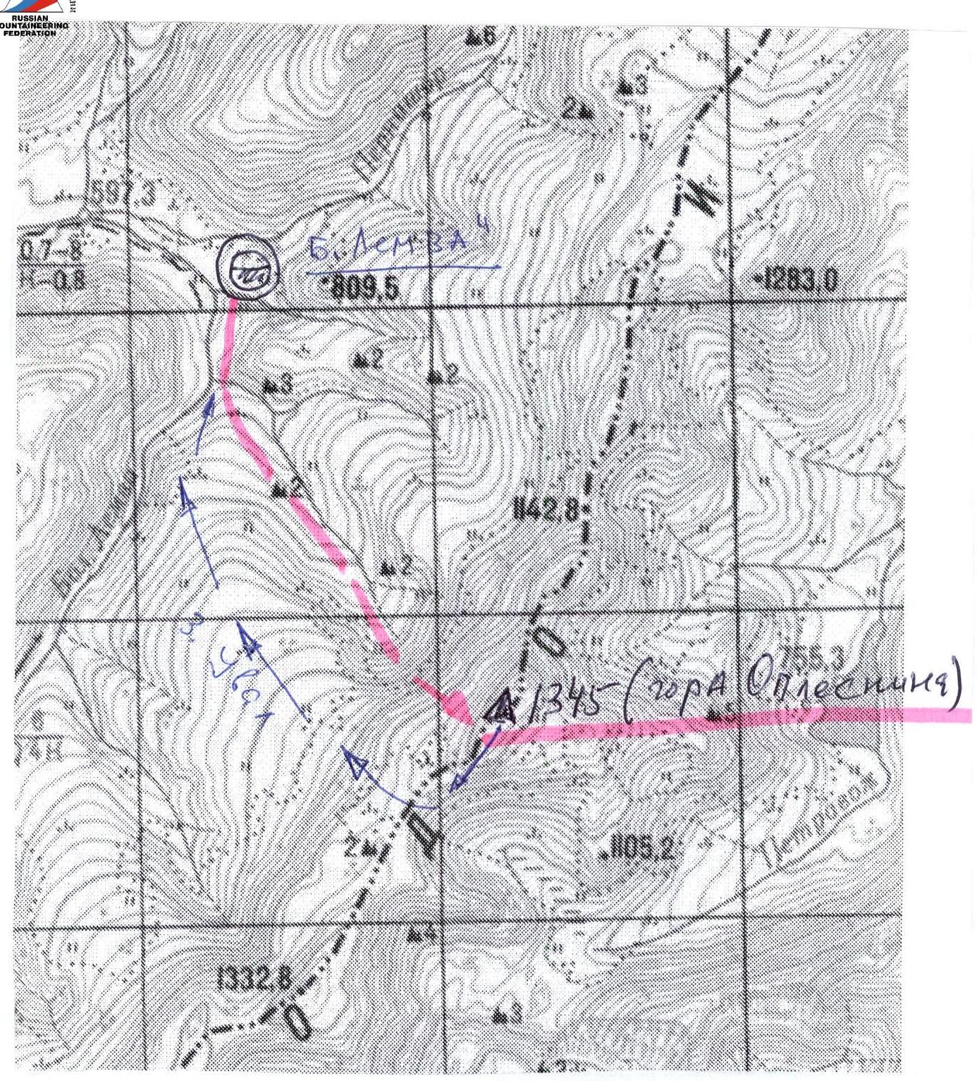 Schematic map, approximate scale 1 cm – 500 m. Descent path along the southern ridge and western slope.
Scheme in UIAA signs, Peak 1245 (Oplesnina mountain), route: via the 6th spur of the western slope
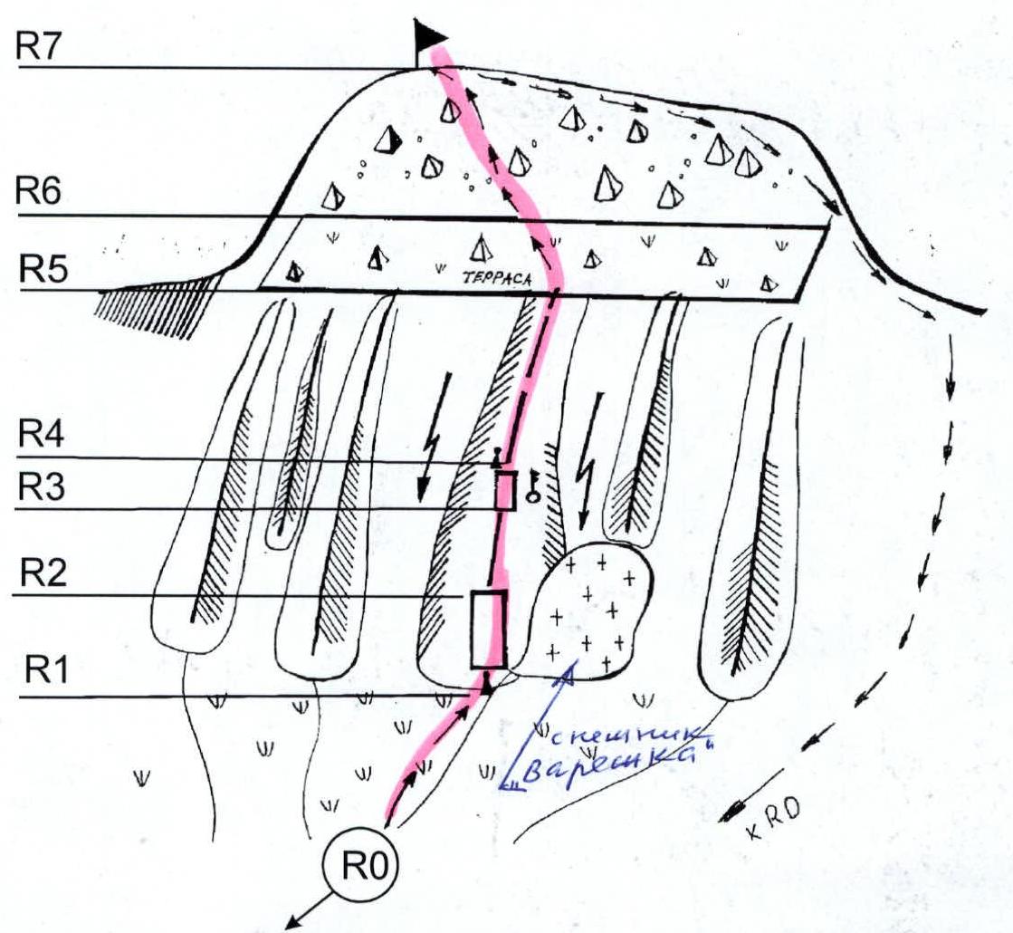
R0 — base camp (conserved geologists' base). R1–R2 — First wall. Section length — 60 m, average steepness — 55°, technical difficulty of the section — 2. At the base of the wall — a control cairn marking the start of the route.
R2–R3 — rocky ridge. Section length — 100 m, average steepness — 45°, technical difficulty of the section — 2, 2.
R3–R4 — key wall when exiting to the second shoulder of the ridge. Section length — 40 m, steepness — 65°, in the upper part — 70°, technical difficulty of the section — 2, in the upper part (key of the route — 10 m) — 3.
R4–R5 — rocky ridge leading to the scree terrace. Section length — 200 m, steepness — 35–25°, technical difficulty of the section — 2, 2.
R5–R6 — traversing the terrace.
- Section length — 500 m
- Average steepness — 15°
- Level of difficulty — 1, 1.
R6–R7 — ascent to the summit scree dome. Large blocks, slabs.
- Section length — 150 m
- Steepness — 25–30°
- Level of technical difficulty — 2.
R7 — Peak 1245 (Oplesnina mountain). R7–R0 — descent along the southern ridge, then into the Bolshaya Lemva River valley and return to the base camp. Does not present technical difficulties.
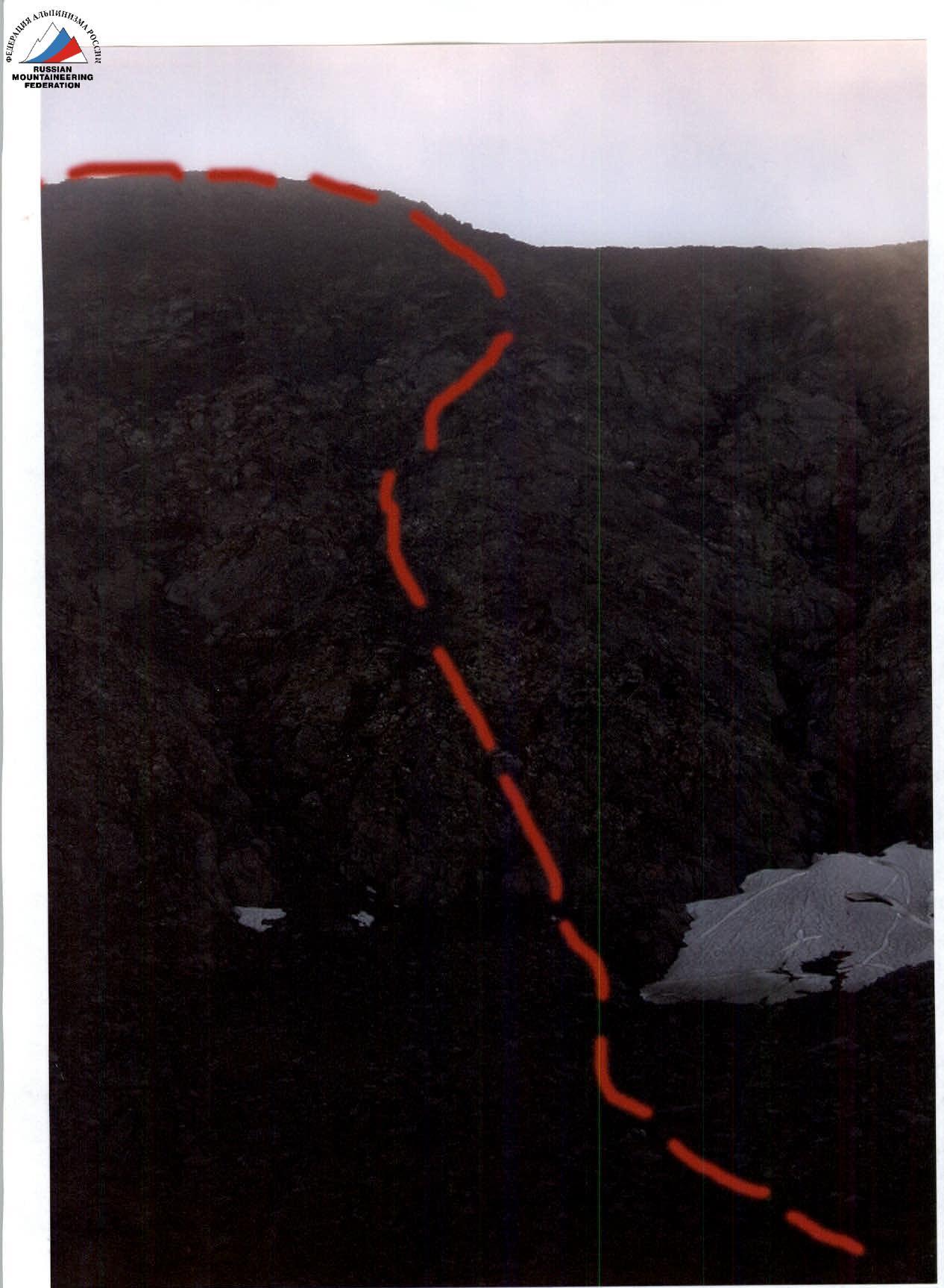
 Upper part of section R1–R2