
Ascent Passport
Region: Subpolar Urals. Ridge: Narod-Itiinsky Ridge (kряж). Valley: Bolshaya Lemva River valley. Mountain massif: main watershed ridge of the Subpolar Urals (section: Lemvaiz peak – Khaimaiz peak)
Section number according to KMGV-2001 - №8. "Other mountain systems, massifs".
Peak name — 1345 (Oplesnina mountain)
Height — 1345
Route name — via the fifth spur of the western slope
First ascent
Proposed category of complexity for inclusion in the KMGV of the Alpine Federation of Russia — 2A category (rocky)
Note: The Alpine Federation of the Komi Republic requests the classification commission of the FAR to credit the group of pioneers with the ascent of 2B category.
Height difference — 675 m Route length — 2000 m Average steepness of the main (technical part) of the route — 55°. Average steepness of the entire route — 45°. Technically difficult sections: sections of 3 category — 1; 4, 5 and higher category of complexity — absent
No pitons were left on the route. Time spent by the team on the ascent:
- Approach to the base camp (conserved geologists' base "Lemva") from the miners' settlement of Pachvoz — 2 days.
Ascent from the base camp — 10 hours.
Leader: Maltsev S. L. (1st sports category, instr. 3 cat., cert. №299, Ukhta)
Participants:
- Punanova A. A. (3rd sports category, Syktyvkar)
- Bondaruk P. A. (3rd sports category, Syktyvkar)
- Druzhinin E. V. (3rd sports category, Syktyvkar)
Coach — Zhuravlev Sergey Vasilyevich (CMS, instr. 2 cat., cert. №1124, Syktyvkar)
Senior coach-releaser — Fomenko Felix Nikolaevich (CMS, instr. 1 cat., cert. №7, Ukhta)
| Departure on the route | — 7:00 August 12, 2006 |
|---|---|
| Arrival at the summit | — 15:45 August 12, 2006 |
| Return to the base camp | — 19:00 August 12, 2006 |
Alpinist event: Volunteer youth scientific-sports alpine expedition "Heights of the Native Land - 2006", dedicated to the 85th anniversary of the statehood of the Komi Republic.
Organizers of the expedition:
- Alpine Federation of the Komi Republic
- Non-profit partnership "Club of Northern Travels - "Sauk-Pai"
- Club of tourists and climbers of Ukhta.
Performed by: Maltsev Sergey Leonidovich, Zhuravlev Sergey Vasilyevich, Gaifert Polina Sergeevna. Syktyvkar, 167000, Internatsionalnaya str., 97, apt. 12. Ph. 24-24-91. E-mail: Zhur58@rambler.ru
 R0 – Base camp
 Semi-profile from the southwest
Alpine Federation of the Komi Republic
NP "Club of Northern Travels "Sauk-Pai"" Club of tourists and climbers of Ukhta
Report on the first ascent
Mountain region: Subpolar Urals Valley: Bolshaya Lemva River valley Ridge: Narod-Itiinsky Ridge (kряж) Mountain massif: main watershed ridge of the Subpolar Urals (section: Lemvaiz peak – Khaimaiz peak)
Peak: 1345 (Oplesnina mountain) Route: via the fifth spur of the western slope Proposed category of complexity for inclusion in the KMGV of the Alpine Federation of Russia: 2A (rocky). (It is proposed to credit the group that made the first ascent with the ascent of 2B category.)
Leader, instr. SP-1: Maltsev Sergey Leonidovich Date of the ascent: August 12, 2006 Alpinist event: Volunteer youth scientific-sports alpine expedition "Heights of the Native Land - 2006", dedicated to the 85th anniversary of the statehood of the Komi Republic.
Senior coach-releaser FA of the Komi Republic — Fomenko F. N. (CMS, instr. 1 cat., cert. №7, Ukhta)
Deputy for safety (natchaspas) FA of the Komi Republic — Zhuravlev S. V. (CMS, instr. 2 cat., cert. №1124, badge №6190, Syktyvkar)
Report prepared by: expedition leader: Zhuravlev Sergey Vasilyevich Address: 167000, Syktyvkar, Internatsionalnaya str., 97, apt. 12. Ph.: (8212) 24-24-91 (home). E-mail: Zhur58@rambler.ru
Syktyvkar, 2006
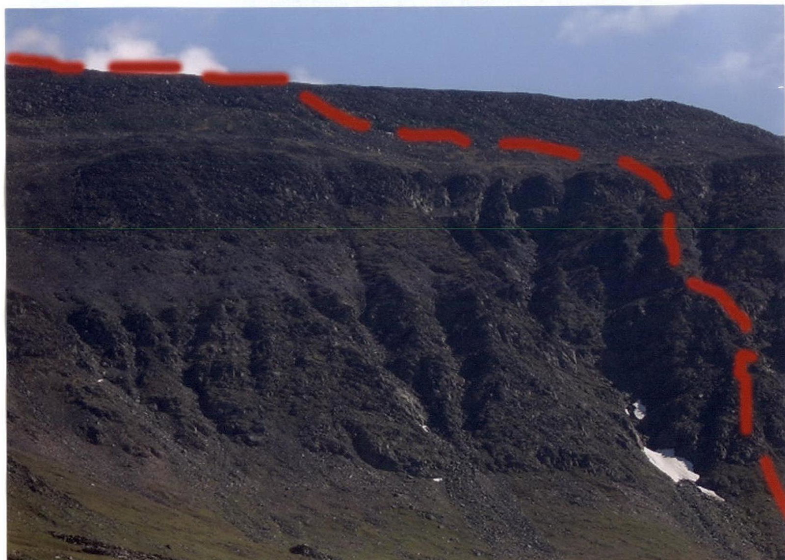 The fifth spur, peak 1345 (Oplesnina mountain), 2A category (rocky). View from the Bolshaya Lemva river valley from the "Western Uval".
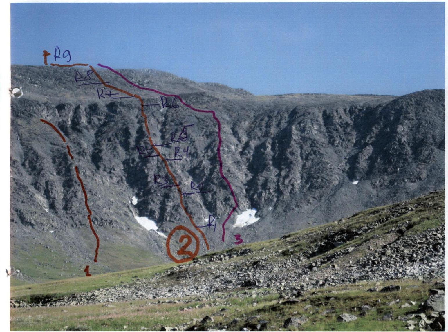 R0 – general view of the route via the 5th spur of the western slope, 2A category (rocky)
 Profile of the route via the 5th spur of the western slope, 2A category (rocky)
Description of the peak
Peak — 1345 (Oplesnina mountain), located on a section between the peaks Lemvaiz (to the south) and Khaimaiz (to the north) of the Main watershed - Narod-Itiinsky Ridge (kряж) of the Subpolar Urals, which separates the valley:
- Bolshaya Lemva river (south, southwest);
- Parnokayu river (north, northwest);
- Ty kotlova river (east, northeast);
- Petrashor river – (northeast).
The main watershed ridge of the Subpolar Urals (on the section peak Lemvaiz – peak Khaimaiz) — a heavily destroyed mountain massif, separating Europe and Asia, breaking off to the west with numerous rocky spurs of the kar type, and to the east (to Siberia) — with long scree slopes.
Peak — 1345 (Oplesnina mountain) — is located in the central part of this section. It is an extended ridge massif, stretched from south to north. The western slopes are rocky kar-type scarps in the form of a series of spurs, close to each other in length and steepness. The summit dome is composed of large fragmentary material.
The name of the peak is not on the map. Among the Ob Komi reindeer herders from the village of Saranpaul, who occasionally graze their reindeer in the Bolshaya Lemva river valley, this peak does not have a local independent name. The name peak 1345 — Oplesnina mountain — was given by the participants of the youth volunteer expedition who made the first ascent.
Description of the route
Approach: from the bivouac in the upper reaches of the Bolshaya Lemva river (conserved geologists' base "Lemva": 3 huts + bathhouse) go upstream along the Bolshaya Lemva river valley to the mouth of a nameless stream flowing into Bolshaya Lemva on the right (10 minutes walk from the base camp). After crossing the stream, ascend along this stream along the left bank under the rocky kar western slope of peak 1345 (Oplesnina mountain).
Technical part of the route: at the base of the spur, organize rope teams, there is a convenient platform for this. Then, start moving along a series of alternating rocky walls (10–15 m) and inclined shelves, then exit to the rocky ridge. The shelves are covered with moss, requiring additional attention from the participants, especially in rainy weather.
Along a series of shelves and walls (the length of the section is within 40–60 m, the level of complexity of the rocks is 2, 2+), ascend to the ridge of the spur. Then simultaneous movement with the rope laid behind large rocky blocks and ledges to a wide inclined rocky shelf (the length of the section is within 200 m, the level of complexity of the rocks is 2). Then a ridge section - a series of gendarmes "Rastcheska". Pass along them, sticking to the right side. Then simultaneous movement along a heavily destroyed non-category rocky ridge with a length of 100 m. Then - exit to the pre-summit terrace, crossing the entire rocky massif of the peak. Cross the terrace and exit to the summit dome, composed of large blocky blocks. Climb to the summit 1345 (Oplesnina mountain) along the large blocks.
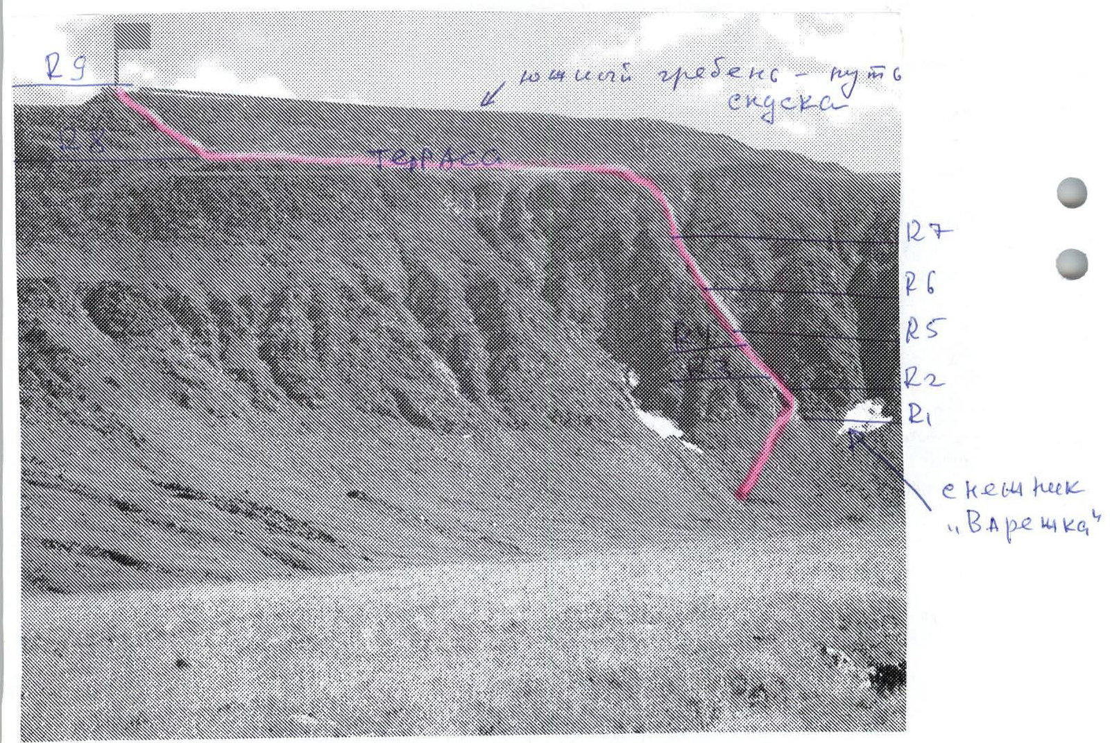
Descent path: Descend along the southern ridge to the scree saddle between peak 1345 (Oplesnina mountain) and peak 1280 ("Edinstvo Rossii"), then along the terrace to the junction from the west, from the Bolshaya Lemva river valley, of the scree ridge (uval):
- descent along the uval to the all-terrain road;
- return to the base camp after exiting the all-terrain road is not difficult.
Required equipment (sports group of 4 people):
- main rope – 2 × 50 m
- hammer sk. – 2 pcs.
- carabiners – 6 pcs.
- pitons – 5 pcs.
- stoppers – 5 pcs.
- quickdraws – 5 pcs.
- station loops – 4 pcs.
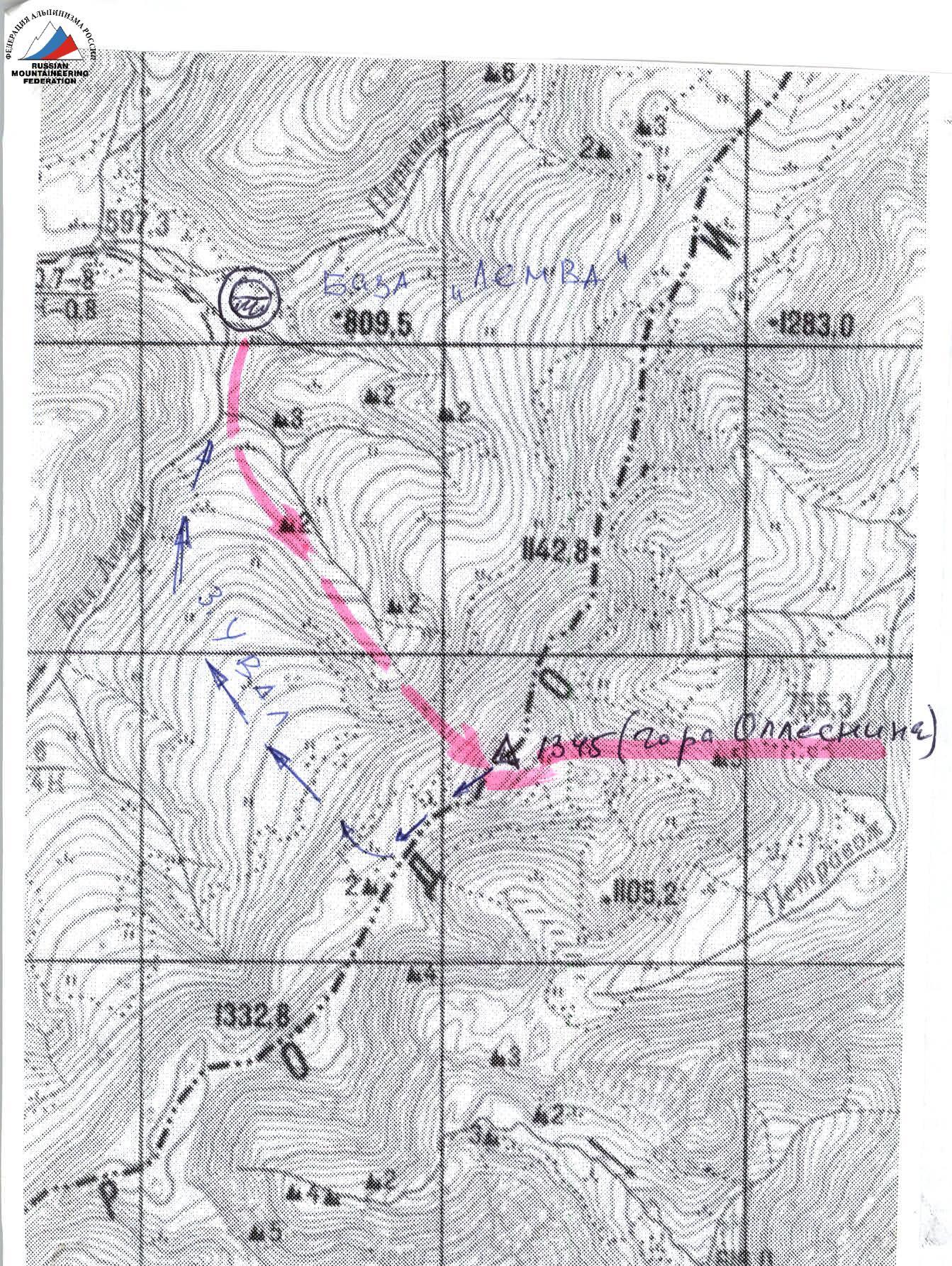 Map-scheme of the ascent to peak 1345 (Oplesnina mountain). Not to scale, approximately 1 cm – 500 m. Descent path.
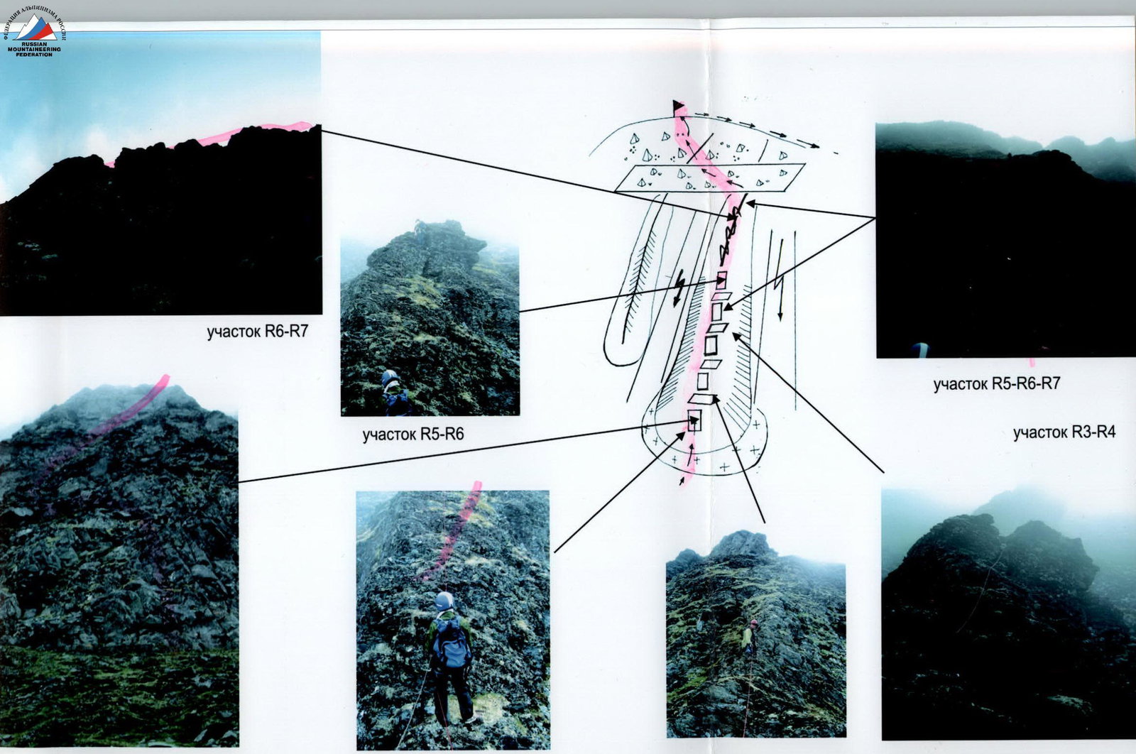
Scheme in UIAA signs
Peak: 1345 (Oplesnina mountain) Route: via the fifth spur of the western slope
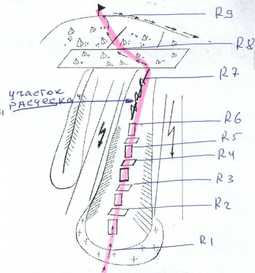
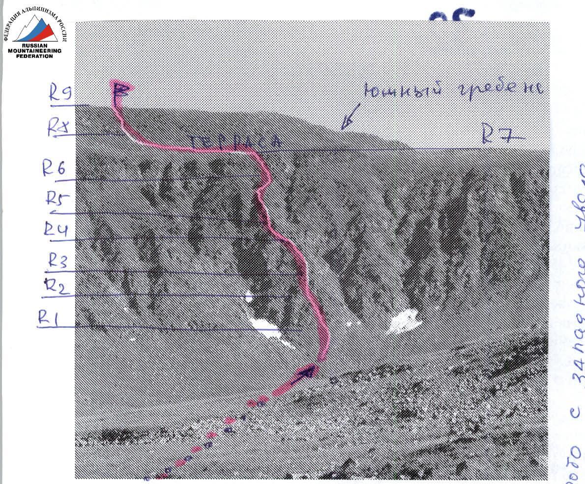
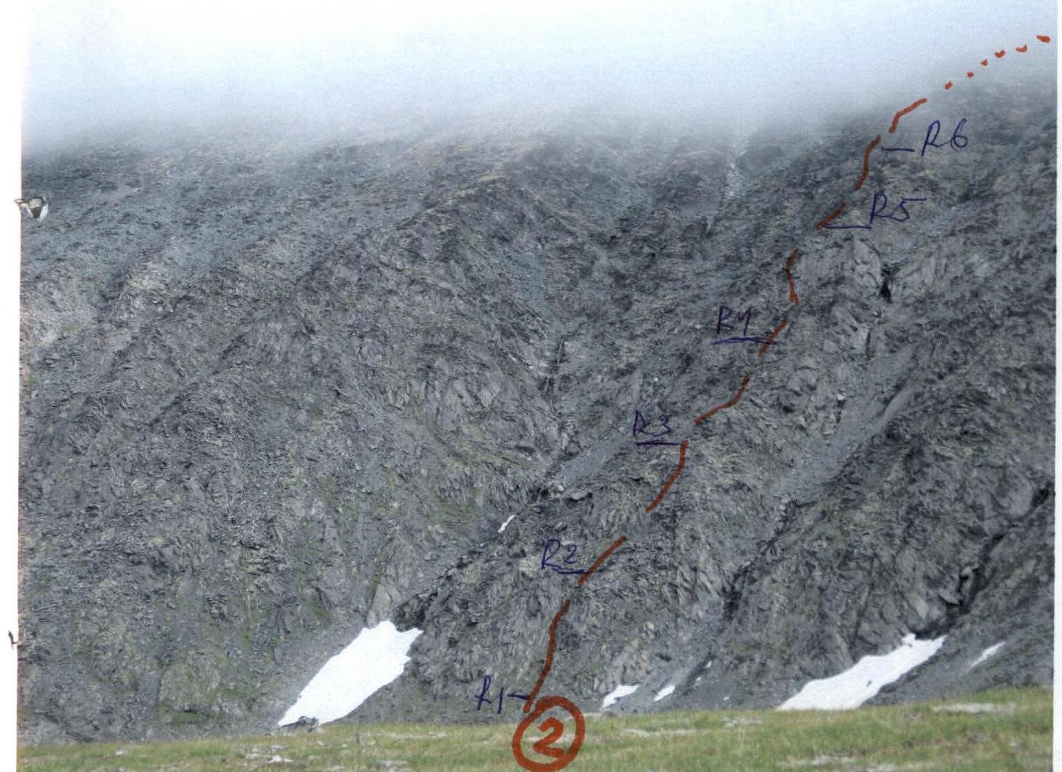
R0 — Bivouac in the upper reaches of the Bolshaya Lemva river (conserved geologists' base "Lemva"). R0–R1 — Approach to the base of the fifth spur. Character of the section — mountain tundra, kurumniks. Length of the section — 2000 m. Level of technical complexity — non-category.
R1–R2 — exit to the rocky ridge of the spur. Rocky walls, slabs. Length of the section — 40 m. Steepness of the section — 40–50°. Level of technical complexity — 1, 1+. Simultaneous movement on a shortened rope.
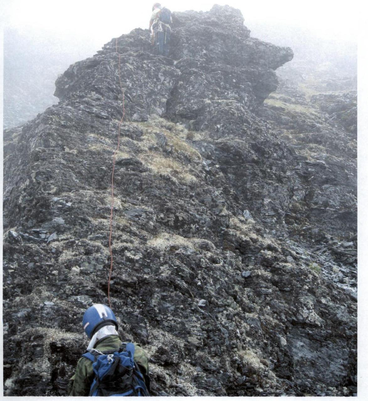
R2–R3 — passage along the rocky ridge of the spur. Ridge. Rocky walls, slabs. Length of the section — 40 m. Steepness of the section — 45–55°. Level of technical complexity — 2, 2+. Simultaneous movement, in some places – alternate belay.
R3–R4 — passage along the rocky ridge. Ridge. Rocky walls, slabs. Length of the section — 40 m, steepness of the section — 45–55°. Level of technical complexity — 2, 2+. Simultaneous movement, in some places – alternate belay.
R4–R5 — approach along the ridge under the rocky tower. Ridge. Rocky walls, slabs. Length of the section — 40 m, steepness of the section — 45–55°. Level of technical complexity — 2, 2+. Simultaneous movement, in some places – alternate belay.
R5–R6 — passage of the rocky tower. Rocky wall. Length of the section — 40 m, steepness of the section — 60°. Level of technical complexity — 2+. Movement with alternate belay.
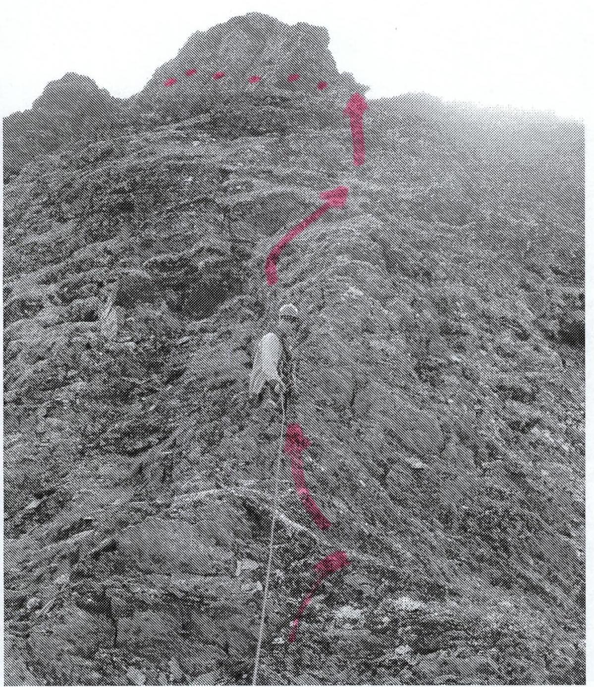
R6–R7 — passage of a series of gendarmes "Rastcheska". Exit to the terrace. Ridge. Rocky walls, slabs. Length of the section — 80 m, steepness of the section — 50–60°, on some sections of 5–7 m — 70°. Level of technical complexity — 2, 2+. Movement with alternate belay.
R7–R8 — passage of the terrace. Heavily destroyed rocks. Length of the section — 100 m. Steepness of the section — 15°. Level of technical complexity — 1. Simultaneous movement on a shortened rope.
R8–R9 — exit under the summit scree dome and ascent to the summit. Large blocks, rocky sections.
- Length of the section — 150 m
- Average steepness of the section — 45°
- Level of technical complexity — 1, 1
- On some sections — 2
- Simultaneous movement on a shortened rope.
R9 — Summit 1345 (Oplesnina mountain).
R9–R0 — descent through the terrace along the western ridge.
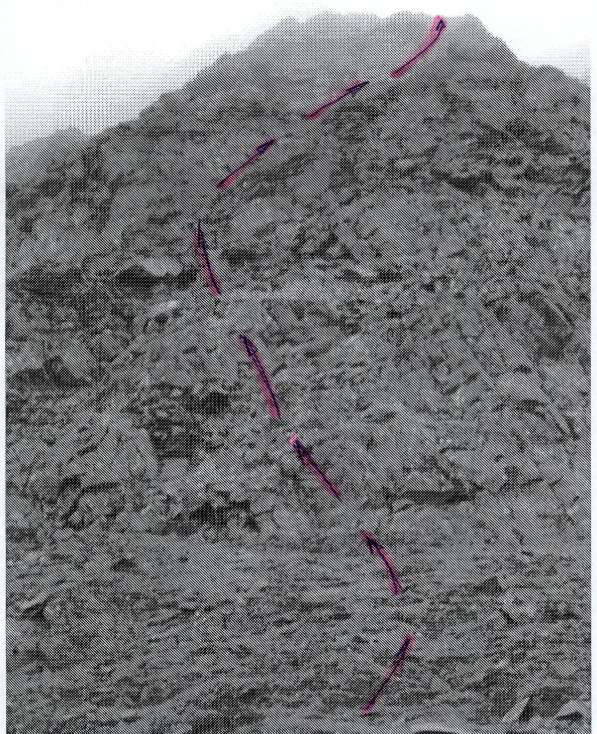 Section R1–R2
 Section R2–R3
 Section R6–R7
Comments
Sign in to leave a comment