Ascent Passport
Region – Subpolar Urals. Ridge – Narod-Ityinsky Ridge (kряж). Gorge – Bolshaya Lemva River Valley. Mountain range: Main watershed ridge of the Subpolar Urals (section: Lemvaiz peak – Khaimaiz peak).
Section number according to KMGV-2001 – №8. "Other mountain systems, massifs". Name of the peak – 1345 (Oplesnina mountain). Height – 1345 m. Route name – via the fourth counterfort of the western slope. First ascent. Proposed category of difficulty – 2A category (rocky). Note: The Alpinism Federation of the Komi Republic requests the classification commission of the FAR to classify this ascent as 2B category for the group of first ascenders.
Height difference – 648 m. Route length: 8 km. Average steepness of the main (technical part) of the route – 65°. Average steepness of the entire route – 45°. Technically complex sections: sections 3, 4, 5, 6 category – none. No hooks left on the route. Time spent by the team on the ascent:
- Approach to the base camp (conserved geologists' base "Lemva") from the miners' settlement Pachvoz – 2 days.
Ascent from the base camp – 10 hours. Leader – commander of the SP-1 detachment: Kremen A. A. (Candidate for Master of Sports, instructor 1st category – certificate №1073, Rostov-on-Don).
Participants:
- Toropov V. A. (3rd sports category, Syktyvkar);
- Gayner P. S. (3rd sports category, Syktyvkar);
- Ivonina I. V. (3rd sports category, Syktyvkar).
Leader – instructor of the SP-1 detachment: Maltsev S. L. (1st sports category, instructor 3rd category – certificate №299, Ukhta).
Participants:
- Bondaruk P. A. (3rd sports category, Syktyvkar);
- Druzhinin E. V. (3rd sports category, Syktyvkar);
- Punanova A. A. (3rd sports category, Syktyvkar).
Coach – Zhuravlev Sergey Vasilyevich (Candidate for Master of Sports, instructor 2nd category – certificate №1124, Syktyvkar).
Senior coach – Fomenko Felix Nikolaevich (Candidate for Master of Sports, instructor 1st category – certificate №7, Ukhta).
Departure on the route – 6:00, August 13, 2006. Reaching the summit – 15:15, August 13, 2006. Return to the base camp – 18:00, August 13, 2006.
Alpinism event: Volunteer youth alpinism scientific-sports expedition "Heights of the Native Land-2006", dedicated to the 85th anniversary of the statehood of the Komi Republic.
Organizers of the expedition:
- Alpinism Federation of the Komi Republic;
- NP "Sauk-Pai North Travel Club";
- Ukhta Tourists and Alpinists Club.
Executed by Zhuravlev Sergey Vasilyevich, Gayner Polina Sergeevna. Contact addresses:
- Syktyvkar, 167000, Internatsionalnaya St., 97, apt. 12.
- Phone: 8 (8212) 24-24-91.
- E-mail: Zhur58@rambler.ru


 Sauk-Pai checkpoint report
Passing the Sauk-Pai checkpoint
Alpinism Federation of the Komi Republic, NP "Sauk-Pai North Travel Club", Ukhta Tourists and Alpinists Club
Report on the first ascent
Mountain region: Subpolar Urals. Gorge: Bolshaya Lemva River valley. Ridge: Narod-Ityinsky Ridge (kряж). Mountain range: Main watershed ridge of the Subpolar Urals (section: Lemvaiz peak – Khaimaiz peak).
Peak: 1345 (Oplesnina mountain). Route: via the fourth counterfort of the western slope. Proposed category of difficulty for inclusion in the KMGV of the Alpinism Federation of Russia: 2A (rocky). (It is proposed to classify the ascent made by the group of first ascenders as 2B category.).
Leader – commander of the SP-1 detachment: Kremen Anatoly Alekseevich. Date of the ascent: August 13, 2006. Alpinism event: Volunteer youth scientific-sports alpinism expedition "Heights of the Native Land-2006", dedicated to the 85th anniversary of the statehood of the Komi Republic.
Senior coach – Fomenko F. N. (Candidate for Master of Sports, instructor 1st category – certificate №7, Ukhta). Deputy for safety (head of rescue team) of the Alpinism Federation of the Komi Republic Zhuravlev S. V. (Candidate for Master of Sports, instructor 2nd category – certificate №1124, badge №6190, Syktyvkar).
Report prepared by: expedition leader Zhuravlev Sergey Vasilyevich. Address: 167000, Syktyvkar, Internatsionalnaya St., 97, apt. 12. Phone (8212) 24-24-91 (home). E-mail: Zhur58@Rambler.Ru Syktyvkar, 2006.

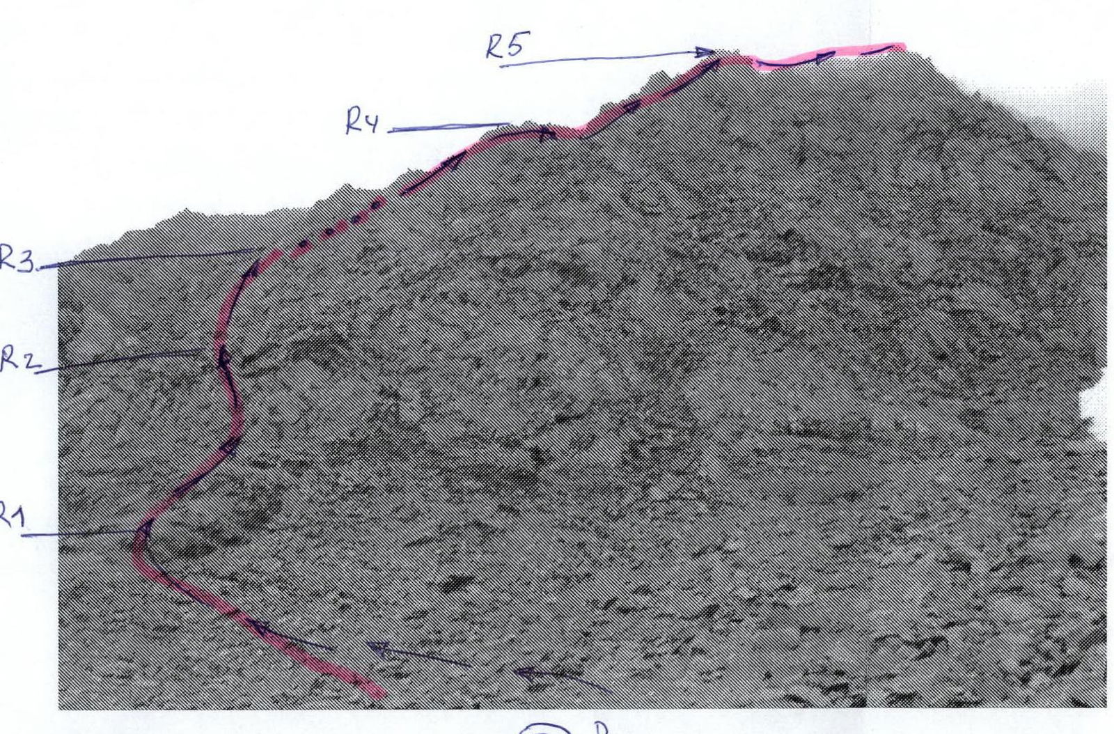
- section R3–R4
- section R3–R5 (profile)
- section R1–R2
- section R4–R5
Description of the peak
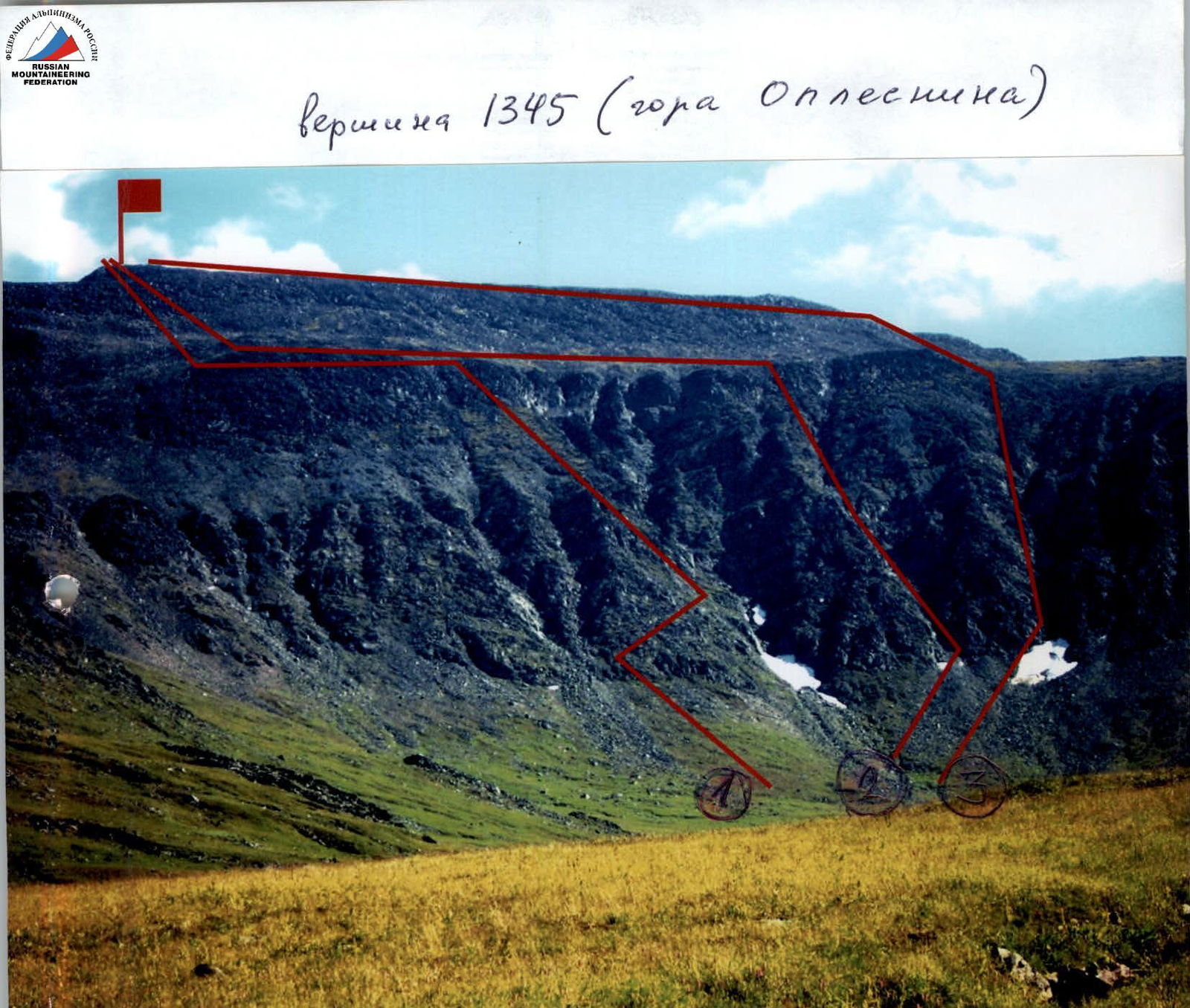
The peak – 1345 (Oplesnina mountain), is located on the section between the peaks Lemvaiz (to the south) and Khaimaiz (to the north) of the Main watershed – Narod-Ityinsky Ridge (kряж) of the Subpolar Urals, which separates the valley of the Bolshaya Lemva River (south, southwest), the valley of the Parnokayu River (north, northwest), the valley of the Tykotlova River (east, northeast), and the Petrashor River (northeast).
The Main watershed ridge of the Subpolar Urals (on the section peak Lemvaiz – peak Khaimaiz) is a heavily destroyed mountain massif, separating Europe and Asia, breaking off to the west with numerous rock counterforts of the corrie type, and continuing to the east (to Siberia) with prolonged scree slopes.
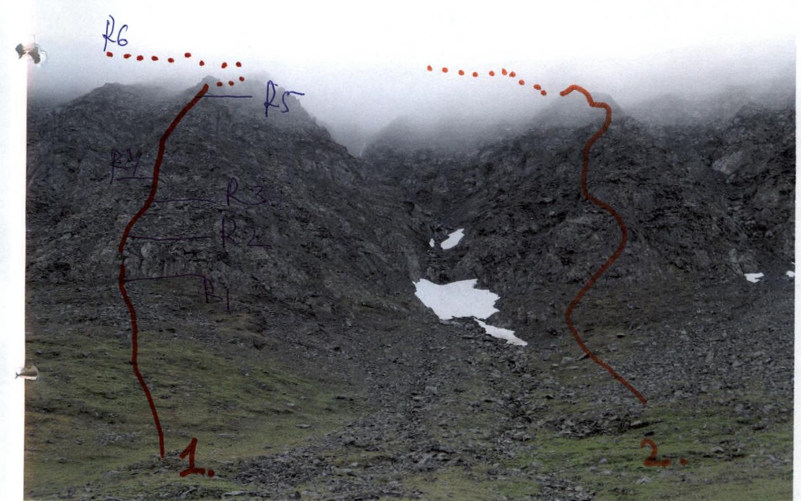
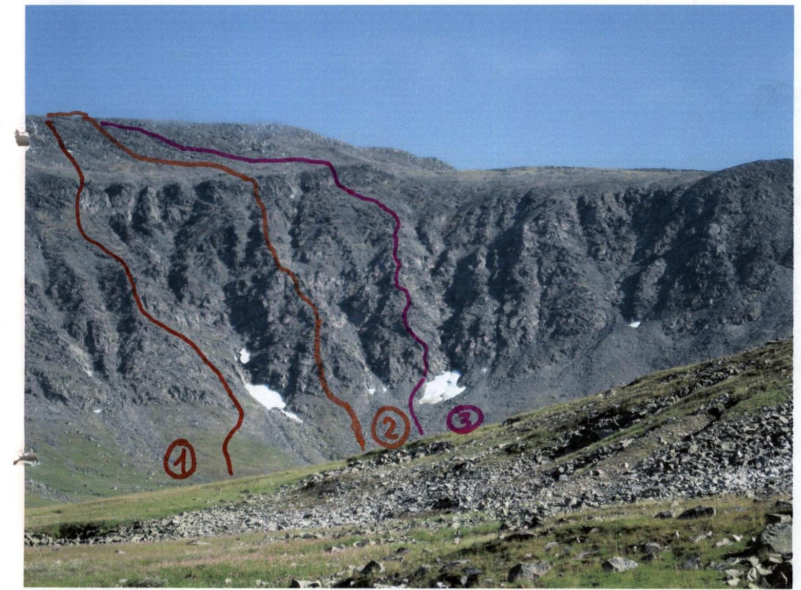
The peak – 1345 (Oplesnina mountain) – is located in the southern part of this section. It is an extended ridge massif, stretched from south to north. The western slopes are rocky, corrie-type counterforts in the form of a series of counterforts close to each other in length and steepness. The summit dome is composed of large fragmentary material.
The name of the peak is not indicated on the map. Among the Ob Komi reindeer herders from the village of Saranpaul, who occasionally graze their herds in the Bolshaya Lemva River valley, this peak does not have a local independent name. The name given to the peak 1345 – Oplesnina mountain – was assigned by the participants of the youth volunteer expedition who made the first ascent.
Description of the route
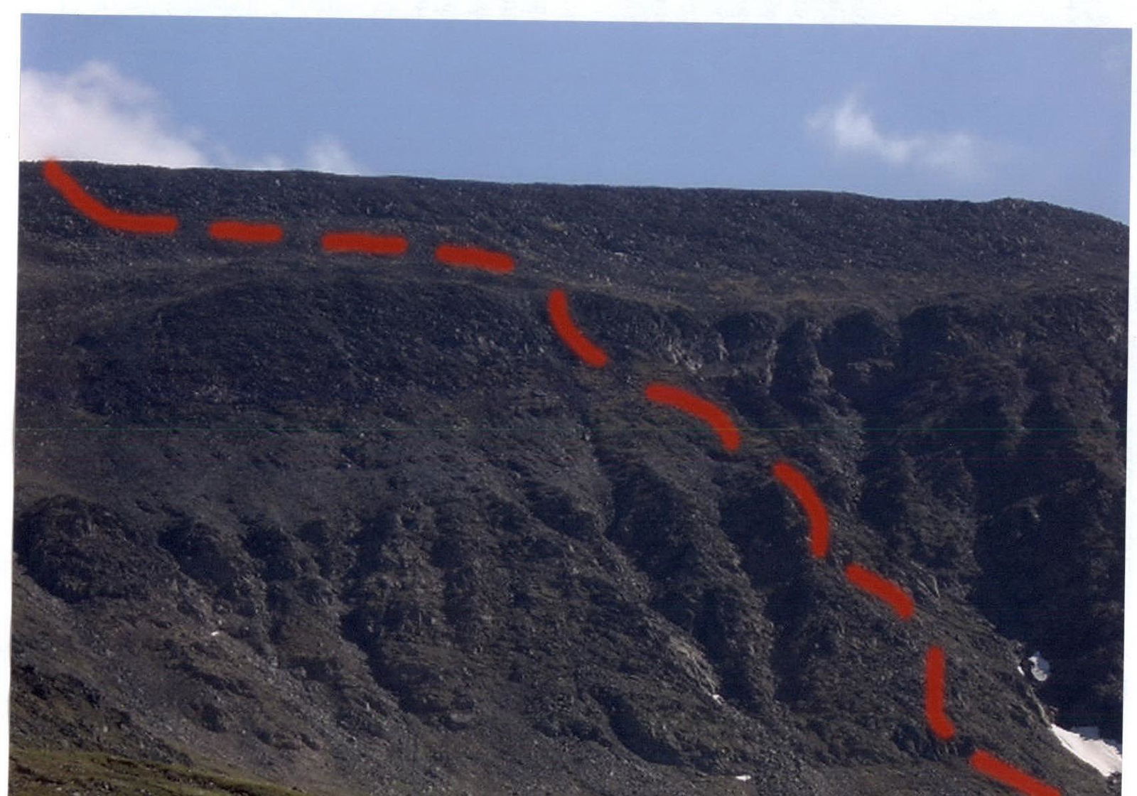
Approach: from the bivouac in the upper reaches of the Bolshaya Lemva River (conserved geologists' base: 3 cabins + bathhouse) go up the Bolshaya Lemva River valley to the mouth of a nameless stream flowing into Bolshaya Lemva from the right. Cross the stream and ascend along it on the left bank under the rocky corrie western slope of peak 1345 (Oplesnina mountain). The fourth counterfort is characterized by a well-defined rocky inner corner at the base of the counterfort. To the left (in the direction of travel) of the inner corner, the technical part of the route begins.
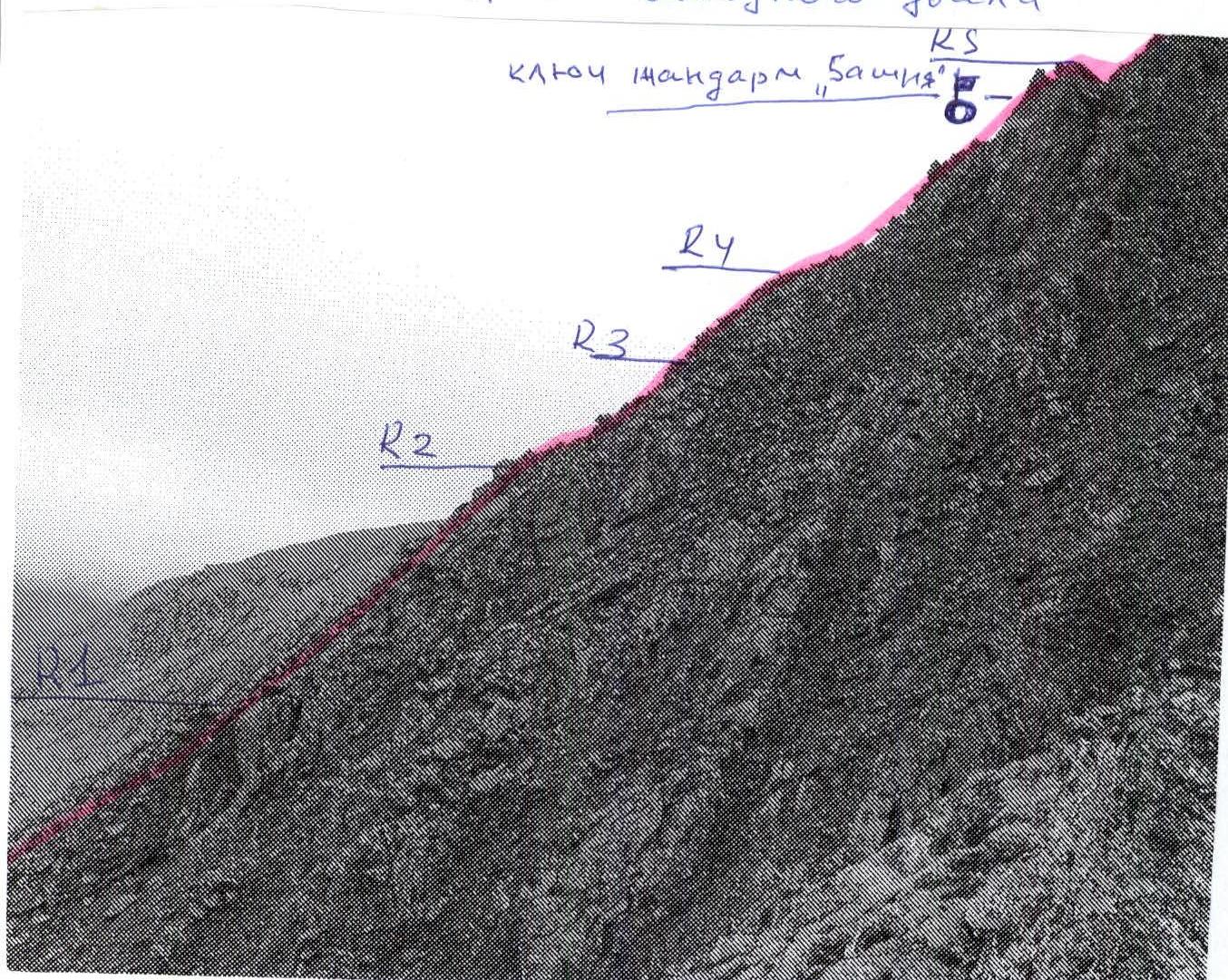
Technical part of the route: At the base of the inner corner, organize rope teams; there is a convenient platform for this. Then, bypassing the inner corner to the left (in the direction of travel), start moving along a series of alternating rocky walls 10–15 m high and inclined shelves. The shelves are covered with moss, requiring additional attention from the participants, especially in rainy weather.
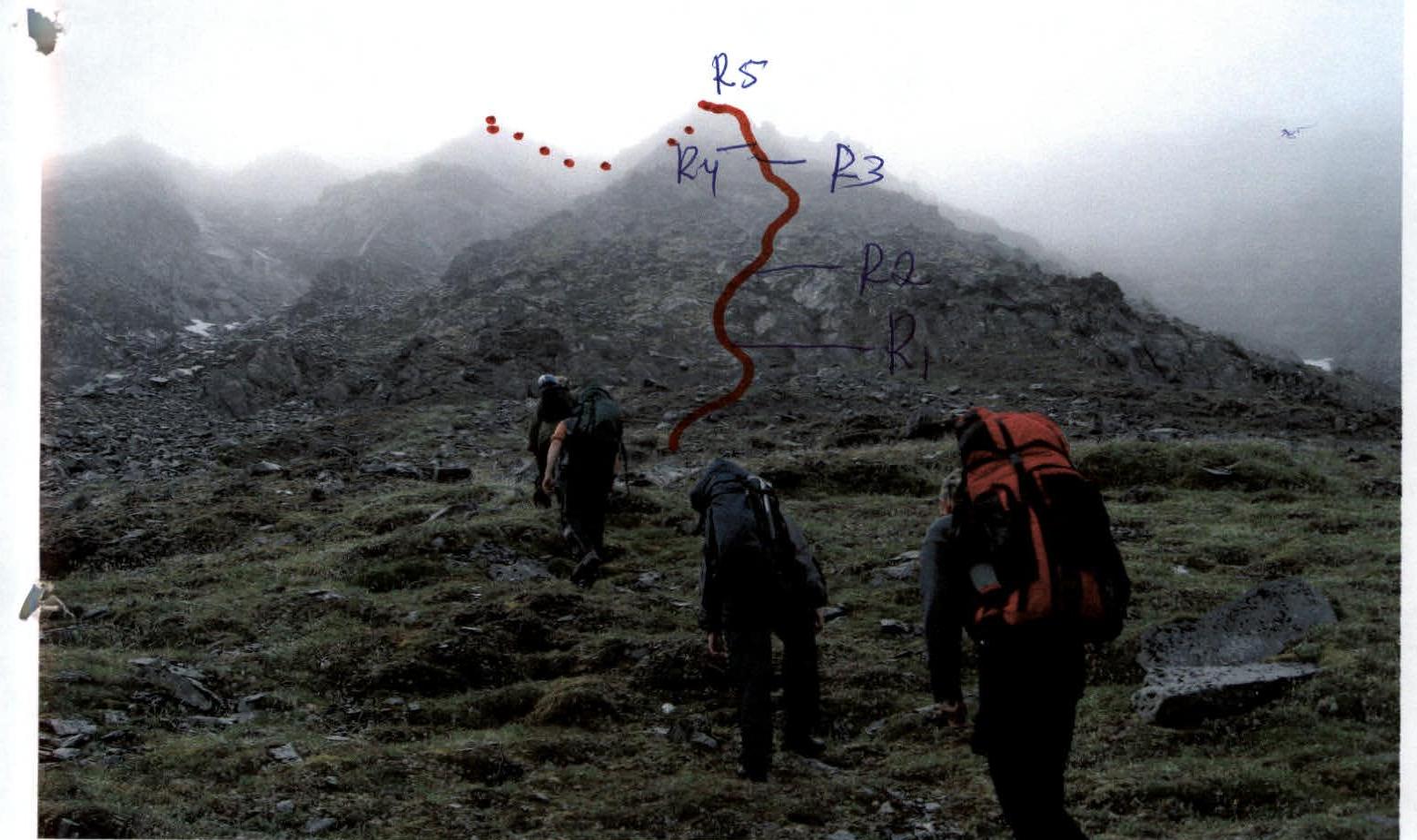
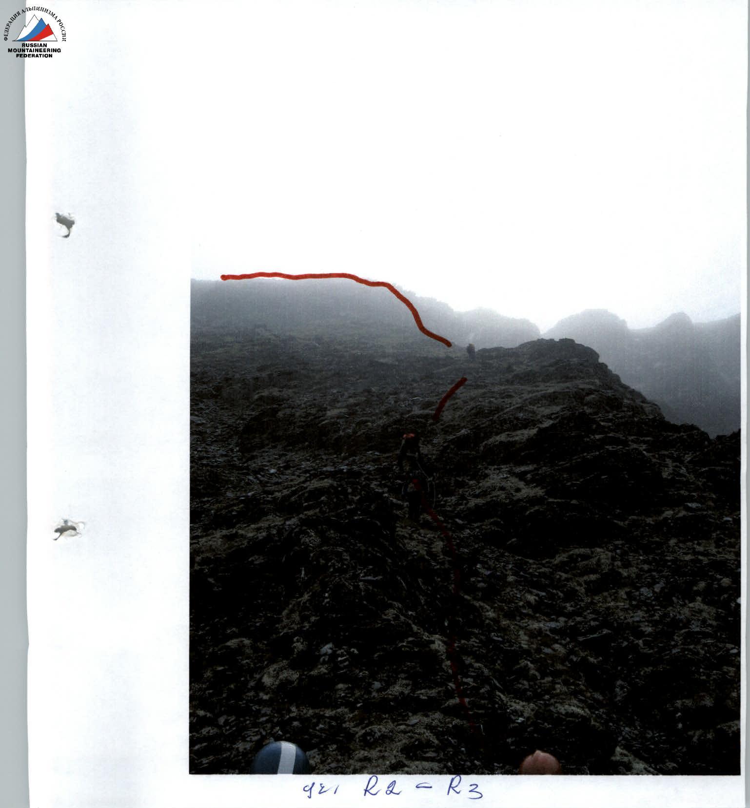
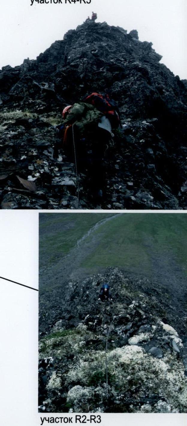
Bypassing the complex inner corner along a series of shelves and walls (the length of this section is within 40–60 m, the level of complexity of the rocks is 2, 2+ category), one should reach the crest of the counterfort. Then, simultaneous movement with the rope laid around large rocky blocks and outcrops up to a wide inclined rocky shelf. (The length of this section is within 80–100 m. The level of complexity of the rocks is 2 category). On the shelf, there is a control cairn.
A large gendarme is bypassed to the left (in the direction of travel) along a series of small inner corners with alternate belay. (The length of this section is 25 m, the level of complexity of the rocks is 2 category).
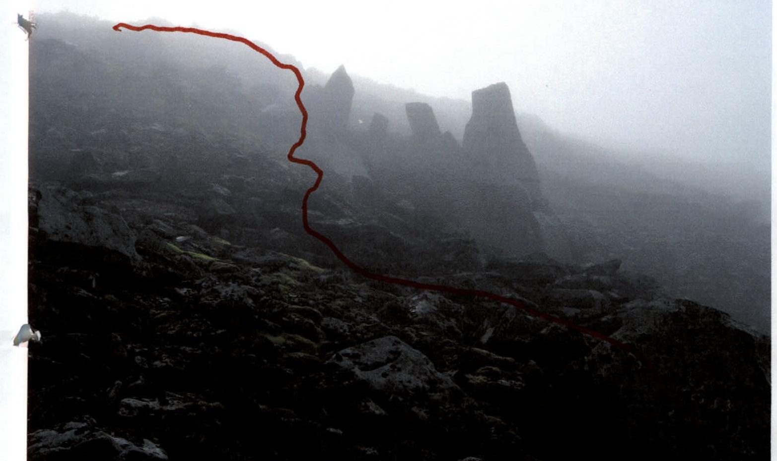
After a series of small inner corners, there is an exit to the key point of the route – the gendarme "Tower". The gendarme "Tower" is passed head-on along a clearly defined central rocky rib. (The length of this section is 25 m, overcome by the interaction of rope teams with the installation of fixed ropes. Dense rocks with numerous holds and convenient cracks and outcrops for organizing intermediate belay points. The level of complexity of the rocks is 2+, 3 category).
Then, simultaneous movement along a heavily destroyed, non-categorical rocky crest about 100 m long. Then, an exit to a pre-summit terrace crossing the entire rocky massif of the peak. Cross the terrace and reach the summit dome composed of large blocky material. Climb to the summit 1345 (Oplesnina mountain) along large blocks.
Descent path: Descend along the southern ridge to the saddle between peak 1345 (Oplesnina mountain) and peak 1280 (Unity of Russia), then along the terrace to the junction from the west, from the Bolshaya Lemva River valley, of a scree ridge (swell). Descend along the scree ridge (swell) to the all-terrain vehicle road. Then, along the all-terrain vehicle road, return to the base camp. (No difficulty).
Required equipment (for a sports group of 4 people):
- Main rope – 2 × 50 m;
- Rock hammer – 2 pcs.;
- Carabiners – 6 pcs.;
- Hooks – 5 pcs.;
- Nut tools (stoppers) – 5 pcs.;
- Quickdraws – 5 pcs.;
- Station loops – 4 pcs.
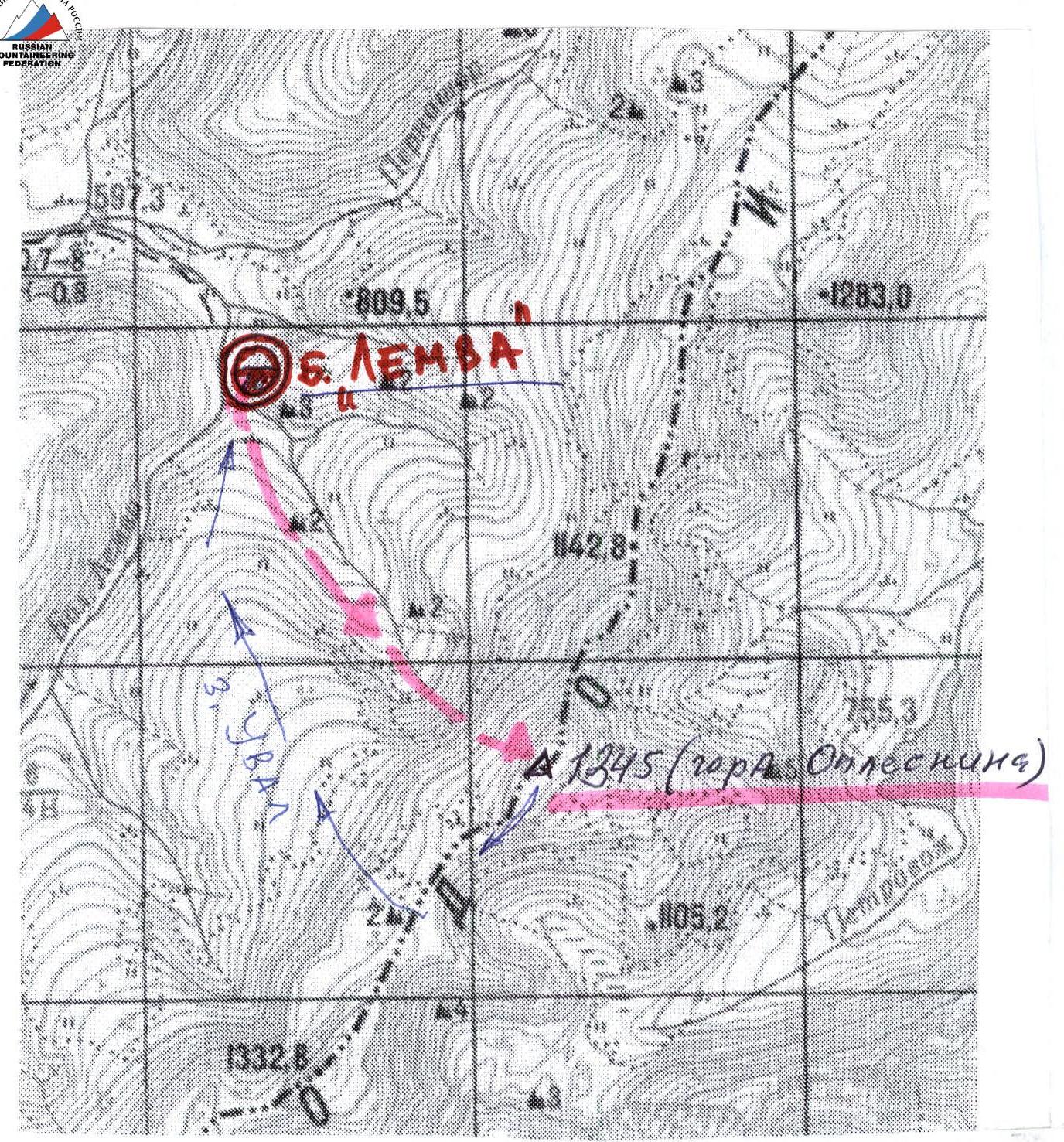
Map-scheme (not to scale, orientation in 1 cm – 500 m): descent path along the western swell.
Diagram in UIAA signs
Peak: 1345 (Oplesnina mountain), route: via the fourth counterfort of the western ridge
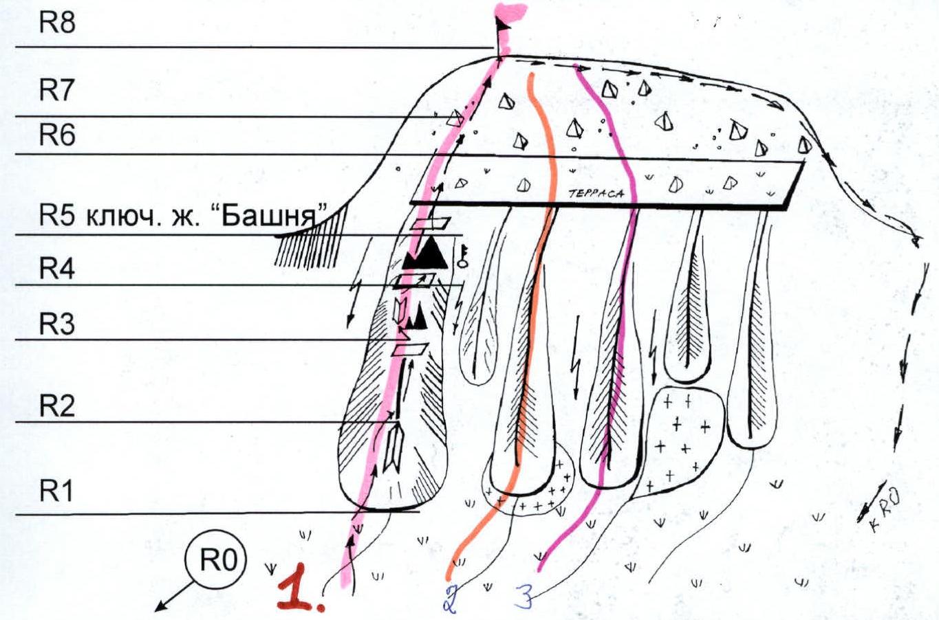
R0 – Bivouac in the upper reaches of the Bolshaya Lemva River (conserved geologists' base "Lemva"). R0–R1 – Approach to the start of the route. Tundra, scree, river crossings. Length of section – 3000 m. Steepness – up to 15°. Level of technical difficulty – n/k. R1–R2 – Bypass of the inner corner. Rocks. Alternating walls, shelves, inclined slabs. Length of section – 40 m. Steepness – 40°. Level of technical difficulty – 2, 2+ category. R2–R3 – Movement along the ridge. Rocks. Alternating walls, shelves, inclined slabs. Bypass of a gendarme to the left in the direction of travel. (Control cairn on a large shelf on the ridge.) Length of section – 80 m. Steepness – 40°. Level of technical difficulty – 2, 2+ category. R3–R4 – Passage of a series of inner corners. Rocks. Length of section – 25 m, steepness – 50°. Level of technical difficulty – 2+ category. R4–R5 – Exit to the gendarme "Tower". Passage of the key section of the route – "Gendarme Tower". Rocks. Wall. Length of section – 25 m. Steepness – 60°. Level of technical difficulty – 2+, 3 category. R5–R6 – Passage of a destroyed ridge. Rocks. Length of section – 150 m. Steepness – 25–30°. Level of difficulty – 1+, 2 category. R6–R7 – Crossing a terrace. Medium-block scree. Length of section – 200 m, steepness – 15–20°, level of technical difficulty – non-categorical. R7–R8 – Exit to the summit plateau and to the summit. Large-block scree. Length of section – 40 m. Steepness – 45°. Level of difficulty – 1+, 2 category. R8 – summit 1345 (Oplesnina mountain). R8–R0 – Descent to the base camp along the southern ridge, terrace, western scree slope, and southwestern scree ridge.