Ascent Passport
- Region, valley, section number according to KMGV 1.1. Region — Subpolar Urals. 1.2. Ridge — Research Ridge. 1.3. Valley — River valley Balbanyu. 1.4. Section number according to KMGV-2001 — 8. "Other mountain systems, massifs"
- Name of the peak, height, route name 2.1. Name of the peak — Narodnaya 2.2. Height — 1895 m 2.3. Route name — via Western ridge from Karkar pass
- Proposed for official ascent (variant, combination) Route by category difficulty 3.1. Proposed 1B category difficulty
- Nature of the route 4.1. Combined
- Height difference, route length, length of sections 5 category difficulty, 6 category difficulty, average steepness of the main part of the route, entire route 5.1. Height difference — 1420 m 5.2. Route length — 2300 m 5.3. Sections of 5 category difficulty — none, 6 category difficulty — none 5.4. Average steepness of the main (technical part) of the route — 60°. 5.5. Average steepness of the entire route — 45°.
- No pitons left on the route. 6.1. Pitons were not used.
- Team's walking hours 7.1. Approach to the bivouac "Behind the all-terrain vehicle" from the geologists' base Zhelannaya — 12 hours. 7.2. Ascent from the bivouac "Behind the all-terrain vehicle" — 12 hours.
- Leader — full name, sports rank, title, participants 8.1. Zhuravlev Sergey Vasilyevich, CMS, instructor 2nd category. 8.2. Participants: * P. Gayner — 3rd sports rank (Syktyvkar) * I. Ivonina — 3rd sports rank (Syktyvkar) * V. Toropov — 3rd sports rank (Syktyvkar) * A. Shershov — 3rd sports rank (Yoshkar-Ola) 8.3. Note: We ask the classification commission of FAR not to include the group in KMGV as pioneers. This route has been mastered by mountaineering enthusiasts since the 1960s, the sports group only classified this route according to the requirements of KMGV.
- Coach, full name, title, instructor qualification. 9.1. Zhuravlev Sergey Vasilyevich, CMS, instructor 2nd category.
- Departure on the route: hour, day, month, year. Departure to the summit, return to the base camp 10.1. Departure on the route — 8:00, August 1, 2005. 10.2. Departure to the summit — 14:00, August 1, 2005. 10.3. Return to the base camp — 16:00, August 1, 2005.
- Organization 11.1. Youth scientific and sports expedition of the Alpinism Federation of the Komi Republic and the National Park "Yugyd Va" — "Victory — 2005", July 15 – August 2, 2005.
Executed by Zhuravlev Sergey Vasilyevich
Syktyvkar, 167000, Internatsionalnaya st., 97, apt. 12, phone 24-24-91, E-mail: Zhur58@rambler.ru
 Natural sports complex "Subpolar Urals".
Natural sports training ground "Balbanyu Valley"
The main peak of the natural sports training ground
"Balbanyu Valley" — Narodnaya (1895 m) — the highest
peak of the Urals.
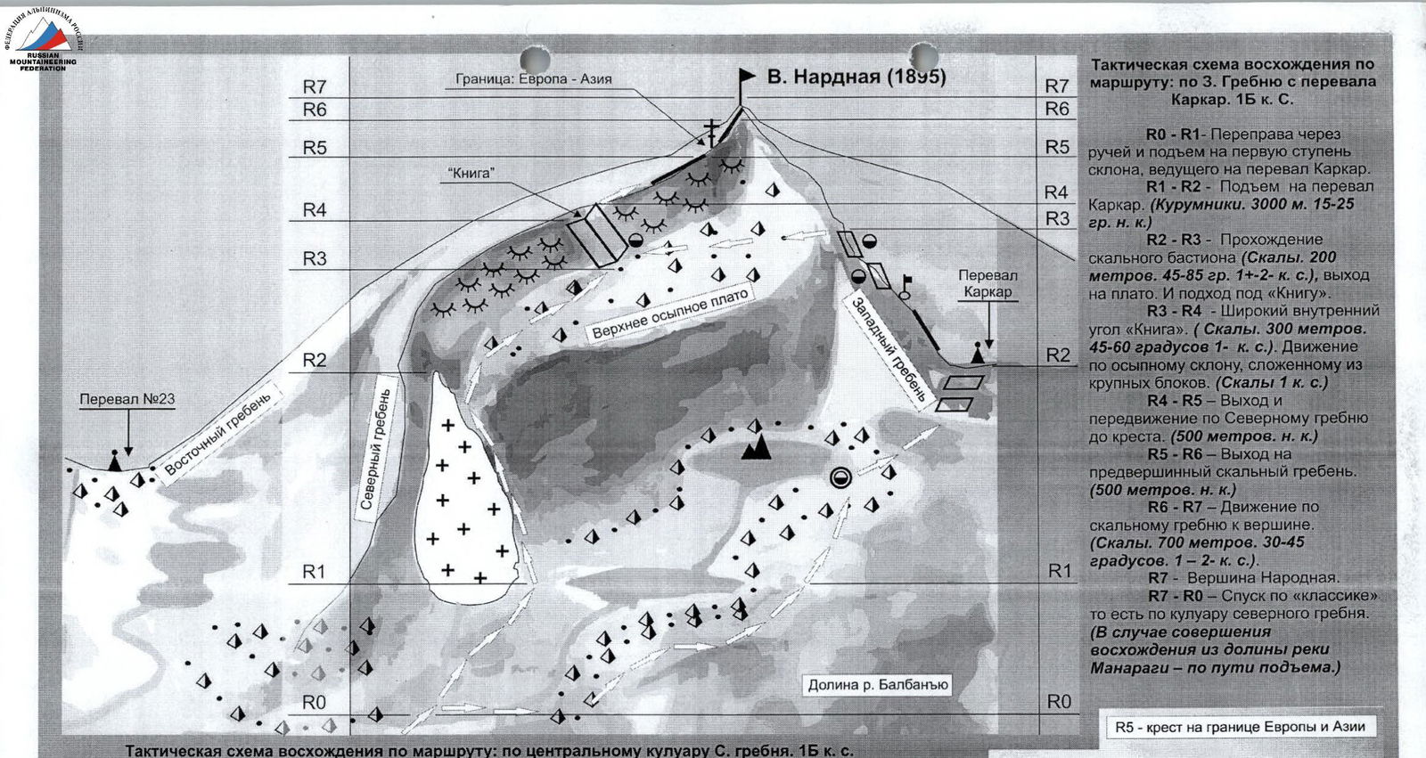
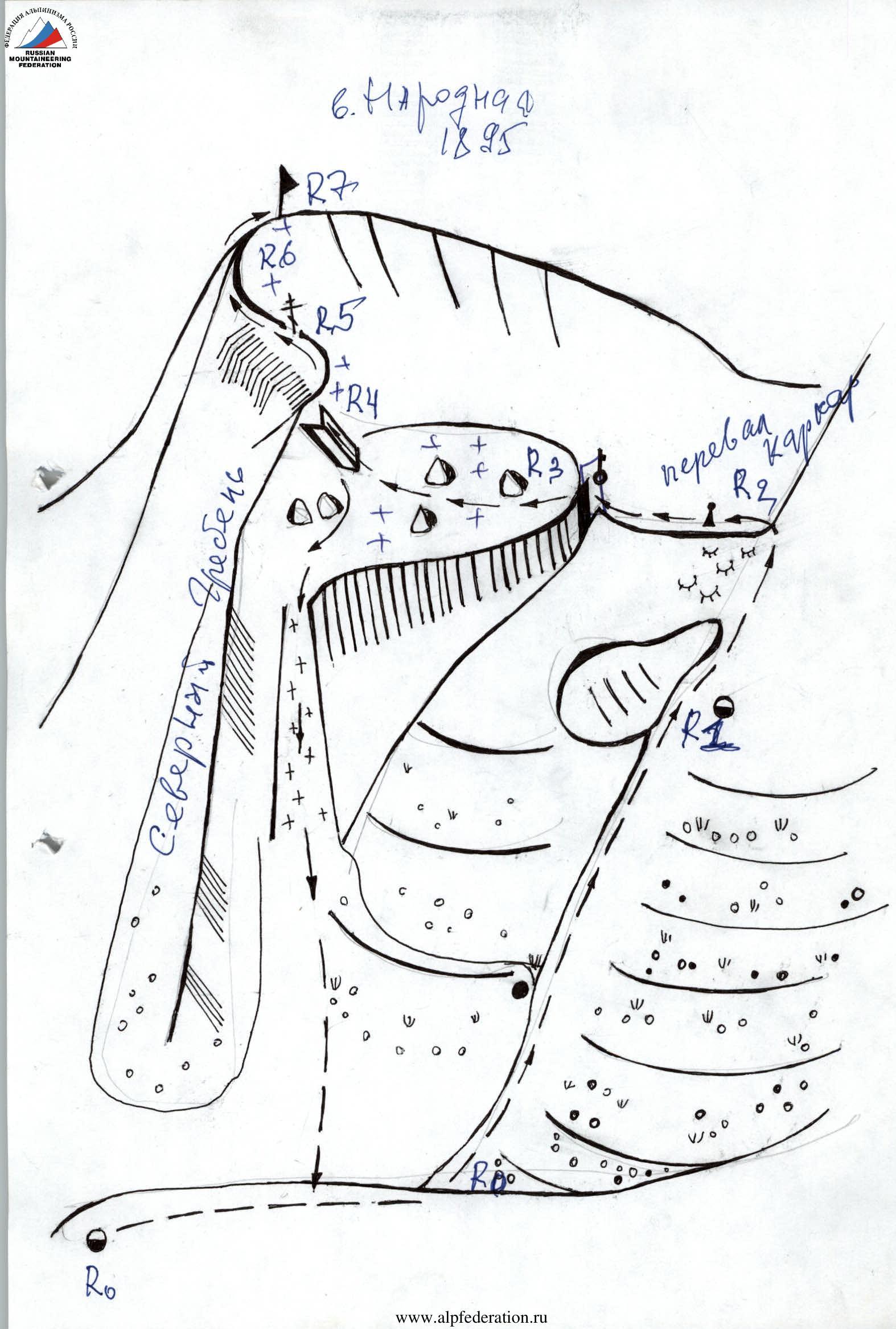
Tactical scheme of ascent via the route: via the 3rd ridge from Karkar pass. 1B category difficulty.
- R0–R1 — Crossing the stream and ascent to the first step of the slope leading to Karkar pass.
- R1–R2 — Ascent to Karkar pass. (Kurumniks. 3000 m. 15–25° easy slope.)
- R2–R3 — Passage of the rocky bastion (Rocks. 200 m. 45–85°. 1+–2B category difficulty), exit to the plateau and approach to the "Book".
- R3–R4 — Wide internal angle "Book". (Rocks. 300 m. 45–60°. 1st category difficulty.). Movement along the talus slope composed of large blocks. (Rocks 1st category difficulty.)
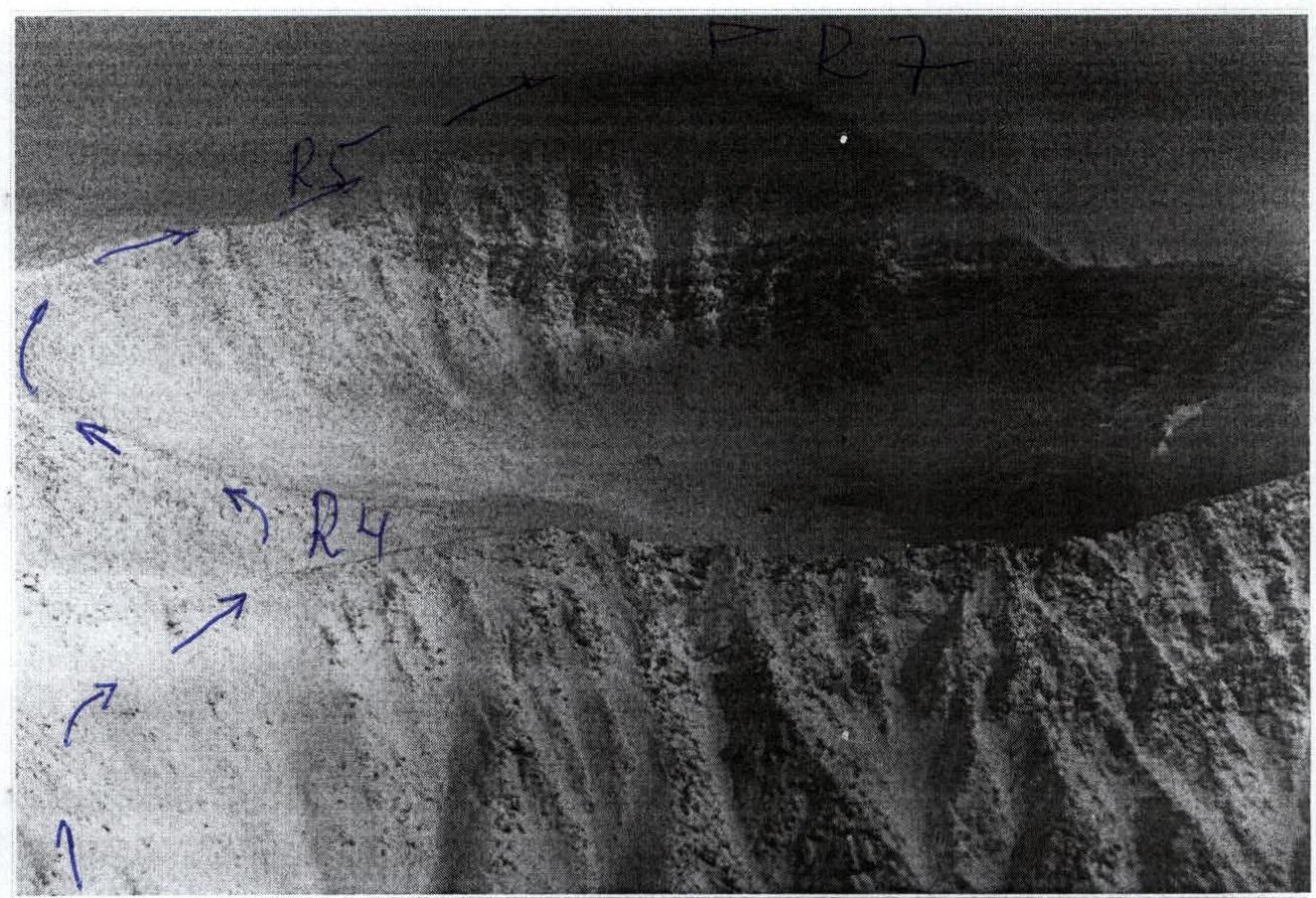
- R4–R5 — Exit and movement along the Northern ridge to the cross. (500 m easy slope.)
- R5–R6 — Exit to the pre-summit rocky ridge. (500 m easy slope.)
- R6–R7 — Movement along the rocky ridge to the summit. (Rocks. 700 m. 30–45°. 1–2 category difficulty.)
- R7 — Summit Narodnaya.
- R7–R0 — Descent via the "classic" route, i.e., via the couloir of the northern ridge. (In case of ascent from the valley of the Manaraga river — via the ascent route.)
R5 — cross on the border of Europe and Asia
Tactical scheme of ascent via the route: via the central couloir of the Northern ridge. 1B category difficulty.
- R0–R1 — Crossing the stream and ascent to the first step of the slope leading to Karkar pass.
- R1–R2 — Ascent via the snow-ice couloir to the northern ridge (Snow, ice, talus. 1000 m. 25–45°. 1–2 category difficulty.)
- R2–R3 — Traverse of the slope and movement along the upper plateau to the internal angle of the "Book". (1500 m easy slope.)
- R3–R4 — Wide internal angle "Book". (Rocks. 300 m. 45–60°. 1st category difficulty.). Movement along the talus slope composed of large blocks. (Rocks 1st category difficulty.)
- R4–R5 — Exit and movement along the Northern ridge to the cross. (500 m easy slope.)
- R5–R6 — Exit to the pre-summit rocky ridge. (500 m easy slope.)
- R6–R7 — Movement along the rocky ridge to the summit. (Rocks. 700 m. 30–45°. 1–2 category difficulty.)
- R7 — Summit Narodnaya
- R7–R0 — Descent via the ascent route.
Description of the summit — object of sports ascents (OSA)
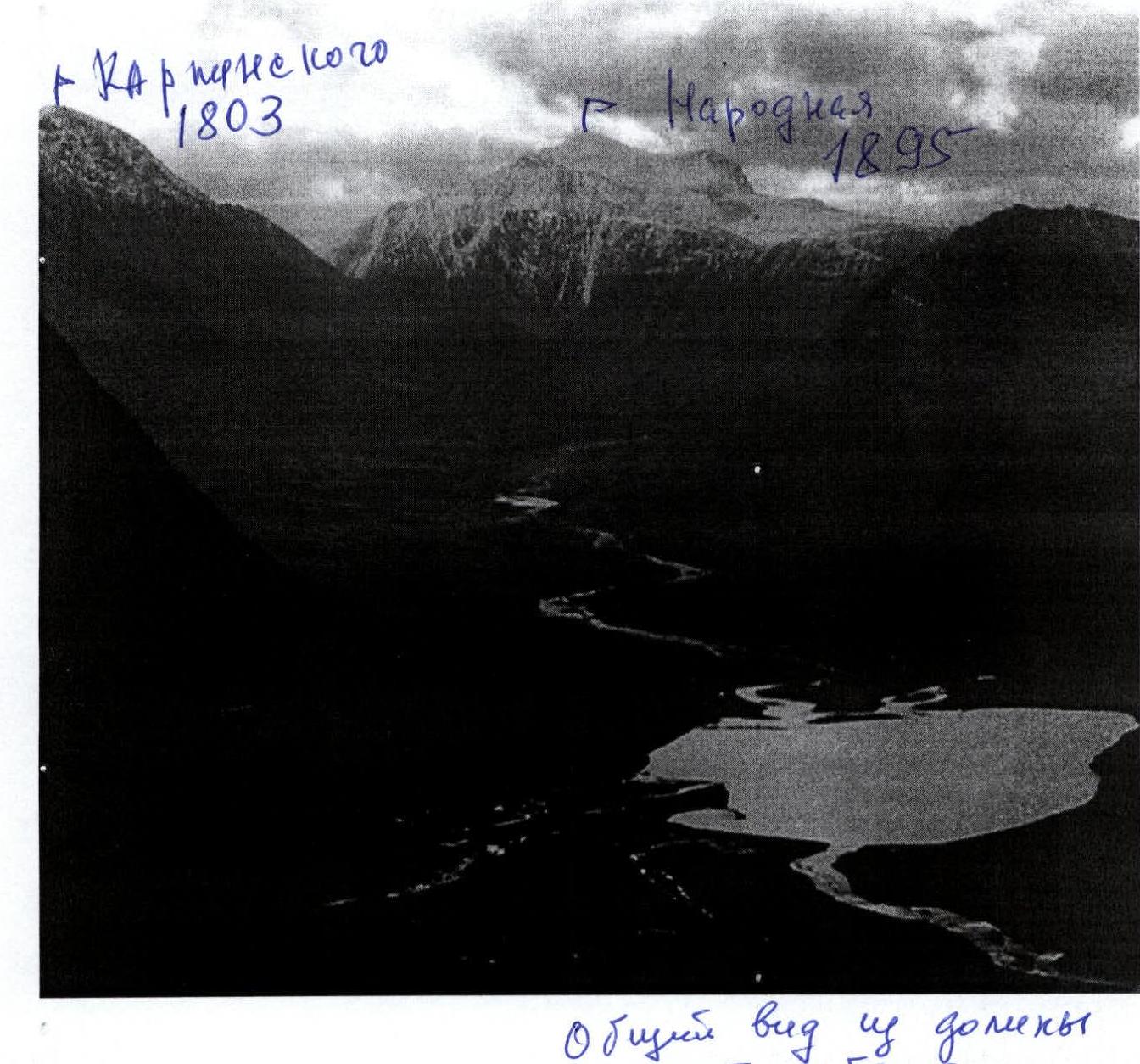
Summit Narodnaya (1895 m) is located in the Research Ridge of the Subpolar Urals. The highest peak of the Ural Mountains. The rivers Naroda, Karpinsk-shor, Manaraga, and Balbanyu originate from its slopes. This is a large mountain massif, attracting tourists and mountaineers from Russia since the 1960s. The name of the summit comes from the river Naroda, but as a result of homonymy, it has long since changed the stress to a more familiar one. However, there are other versions of the origin of the cartographic name. Ascents to Narodnaya are interesting from all sides. Routes along various ridges have been mastered, although not classified. Wall routes are still "problematic", but this is not so much due to their technical complexity, as to the remoteness of the massif, which for a long time was not considered an object of sports ascents. Photo from the summit of Barkova, August 2003. Author E. Shubnina
Description of the route object of sports passages (OSP)
Approaches and bivouac: Ascent to Narodnaya via the western ridge can be made from the valley of the Balbanyu river or from the valley of the Manaraga river. The traditional path is from the valley of the Balbanyu river, as this path is provided with transport: the geologists' base Zhelannaya can be reached by "Ural" all-terrain vehicles.
- Further, the path goes upstream along the river on the old geological all-terrain vehicle road to
the traditional place of camps under the northern ridge of Narodnaya. The river is crossed without problems by stones in the upper reaches. A characteristic landmark: 1 hour before the traditional camps on the left bank of the Balbanyu river, an abandoned all-terrain vehicle is visible.
Thanks to this all-terrain vehicle, the campsite got the name "Campsite behind the all-terrain vehicle".
The campsite is convenient:
- with flat areas for tents,
- with "near" water — a good flowing stream,
- but without firewood, as they are located in the zone of goltsovye tundras. Three routes to Narodnaya can be started from these camps.
Technical description of the route: Movement from the "campsite behind the all-terrain vehicle" begins with crossing the tributary of Balbanyu, originating from several streams, flowing from mountain lakes. It is necessary to cross to the right bank. Then start ascent along the grassy slope along the talus "paw" of the northern ridge of Narodnaya, along the right bank of the stream flowing from the slopes of Narodnaya. The stream valley is gully-like, steep, landslide-prone. It is recommended to move: * without descending into the stream valley, * but not climbing under the rocks of the northern ridge, where rockfall is possible. Olen' trails serve as a good landmark for the recommended level. Traverse the slope to exit to a large tundra plateau with a large lake. Cross the stream at the headwaters and then along the left bank of the stream, then along the left bank of the lake, from which the stream flows, approach the rocky base of Karkar pass. The entrance to the pass is zigzag-shaped, with elements of climbing on large rocky blocks. The pass point is well expressed. False "twins" are not present. From the pass, movement along the rocky ridge to the left upwards, adhering to the right slope. Highly destroyed rocks. The section is rockfall-prone in the summer. Further a small rocky "bastion" with complicated climbing. After which there is an exit to the upper talus plateau. The plateau is quite solid in size. It poses a danger during orientation in the fog. Further movement to the right, to the ridge. Then along the talus ridge, alternating with rocky sections, exit to the pre-summit shoulder. Here a cross is installed. Here, too, the border passes, dividing the continent into Europe and Asia. Further past the cross along the ridge along simple dense rocks of small steepness exit to the summit. Many memorial signs are installed on the summit. The most noticeable in bad weather is a triangular pyramid with a ball, installed to commemorate the anniversary of the statehood of the Khanty-Mansi Autonomous Okrug, on whose territory the highest point of the Urals is located. Descent to the plateau via the ascent route. Further along the snowy couloir of the northern ridge (i.e., "via the classic"). The time taken for the ascent in good weather from the base camp to the summit and back to the base camp takes 12–16 hours. Special equipment (calculation made for a training group NP-1 of ten people): rope main 3×40, pitons rocky 3, ice ax (rocky hammer) 1, loops station 3. Primus, kettle. Since ascents along this route have been made for many decades, it is practically impossible to identify the pioneers of this route. Main difficulties:
- Large height difference.
- Frequent fogs and abundant snowfalls on top (from the upper plateau to the summit) in the summer period.
- The summit of Narodnaya constantly holds a cloud-flag.
- Fogs interfere with orientation on a large mountain massif, with rocky ledges along the outer edges of the plateau.
- Snowfalls cover talus slopes, masking stone traps.
- Stones and sections of rocks heated by the sun, covered with snow, are covered with ice. An additional reserve in the summer can be called the polar day. White nights allow using this resource to search for and organize the descent of a delayed group.
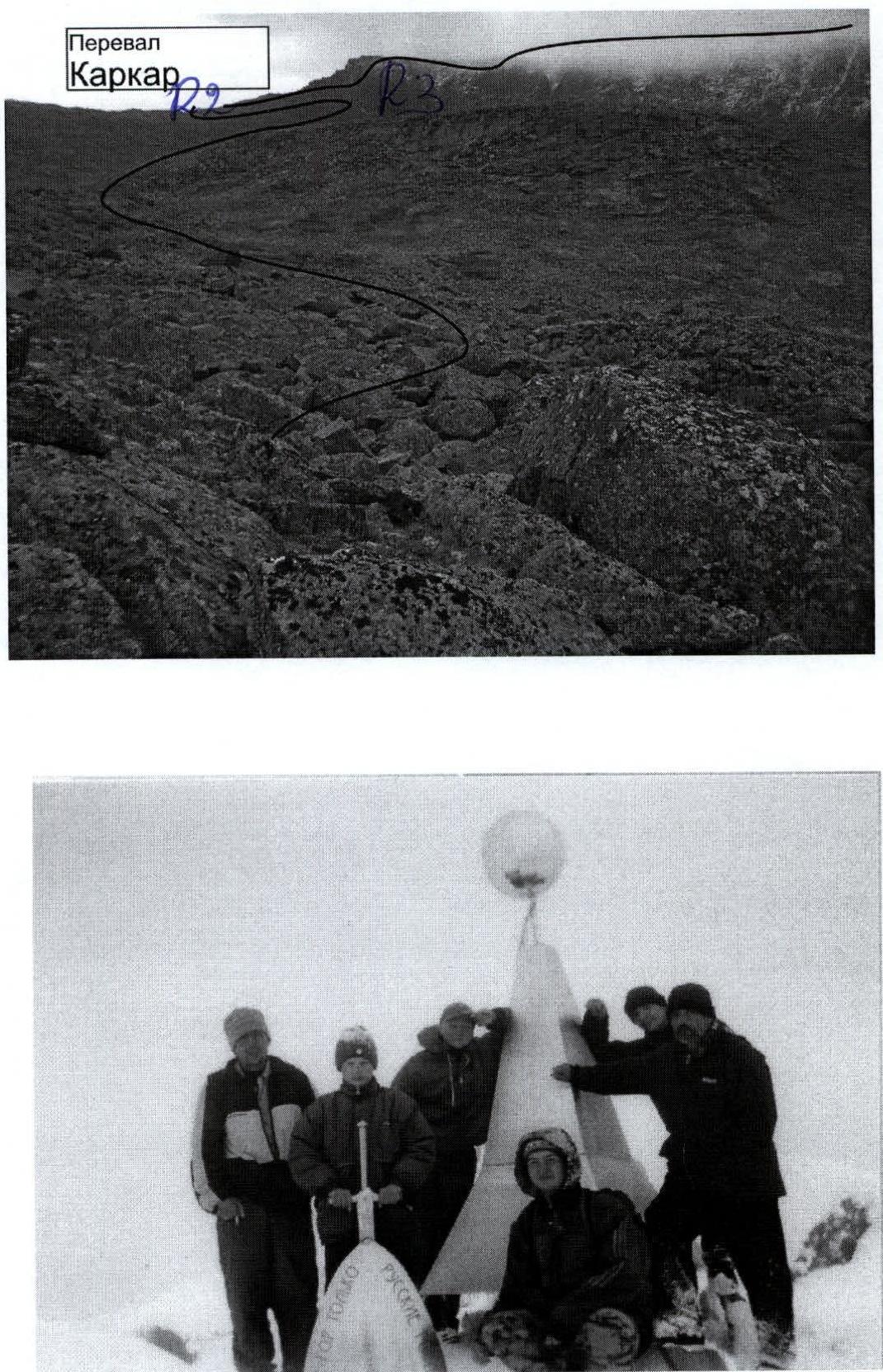
On photo № 1 — view of Karkar pass and rocky ridge (western), leading from the pass to the upper plateau of Narodnaya. On photo № 2 — on the summit of Narodnaya (August 2004).
Ascent Passport of the alpinist route
Summit Narodnaya (1895 m) via Western ridge from Karkar pass 1B category difficulty.
PSC "Subpolar Urals". PSP "Valley of the Balbanyu river".
| № | Administrative district of the Russian Federation | North-Western |
|---|---|---|
| 1 | Subject of the Russian Federation | Komi Republic |
| 2 | Administrative region | Inta region |
| 3 | Natural sports complex (PSC) | "Subpolar Urals" |
| 4 | Natural sports training ground (PST) | "Balbanyu Valley" |
| 5 | Mountain range | Research Ridge |
| 6 | Mountain spur | Mountain "horseshoe": peak Chernaya – peak Erkusei – peak Starik – peak Starukha – pass Severny – pass Karpinsky – peak Narodnaya – peak Limbeko-iz. |
| 7 | Mountain massifs included in this PST | 1. Research Ridge. 2. Narodo-In'insky ridge. 3. Maldy-Nyrd ridge. |
| 8 | Peak (object of sports ascent) | Peak Narodnaya. Height above sea level — 1895 m |
| 9 | Route (object of sports passage) | Western ridge from Karkar pass |
| 10 | Time taken for the route | 8–10 hours from the base camp under Limbe pass |
| 11 | Category of difficulty | 1B |
| 12 | Analogues of the route: | 1. Kaidzhany M. North ridge (North Ossetia, Kaidzhany tract). 2. Peak Nikolaeva via the southern slope (North Ossetia, Tsey valley). |
| 13 | Features of the route | Corresponds to the requirements of a combined route of 1B category difficulty. |
| 14 | Recommendations | The route is promising for climbers NP-1, NP-2, making official ascents for the standard of the "Alpinist of Russia" badge, as well as for training groups performing standards for the 1st youth rank in alpinism. During the ascent, it is possible to train the interaction of links on various types of mountain relief, both when moving up and when moving down. |
| 15 | Route passed and classified | We propose the route to FAR for classification without indicating a group of first ascenders. Expert group consisting of: S. Zhuravlev (Syktyvkar, CMS, 2nd instructor category), Polyakov S. N. (Syktyvkar, 1st sports rank, 2nd instructor category), Shulepov G. G. (Syktyvkar, 1st sports rank, 3rd instructor category), Eremин M. A. (2nd sports rank, 3rd instructor category) believe that the route meets the requirements. |
| 16 | Required additions: Protected territories, Transport, Communication, Organization of search and rescue operations | Peak Narodnaya is located on the protected territory of the national park "Yugyd-Va" of federal subordination. The most convenient is the delivery of workers and participants of VUSL (outdoor training and sports camp) or VUTS (outdoor training and competition camp) by car from the city of Inta. Organization of communication within VUSL or VUTS is convenient with the help of VHF-radio stations. For communication with the city of Inta, if necessary, there is a constantly operating radio station at the geologists' base Zhelannaya, which is located 3–4 hours from the bivouac under Limbe pass. Forces of the public rescue team of the alpinist event. If necessary, it is possible to connect the PSO EMERCOM of Russia, based in the city of Inta. |
Notes:
- The name of the natural sports training ground is determined geographically.
- Cartography and schemes in UIAA signs, photographic materials are attached.
Classification of the route via the Western ridge to Narodnaya summit — a timely necessity, allowing to introduce one of the most popular routes of the Subpolar Urals into a single classification of alpinist routes.
Description of the summit (OSA)
Narodnaya summit — the highest peak of the Urals — 1895 m above sea level, one of the most visited natural objects of the Komi Republic. Mountaineers and tourists from Russia, the near and far abroad are attracted by its absolute Ural height and transport accessibility (relatively other peaks of the Subpolar and Polar Urals). It is also attractive that during the ascent, the Ural border between Europe and Asia is crossed. The names of the first ascenders to Narodnaya should be sought in the lists of geodetic expeditions of the 1930s, or even earlier. The etymology of the name of the summit is still debated: whether it is from the name of the Siberian river Naroda, originating from the slopes of this peak, or from the word "people". The name is established, marked on all maps. The mountaineering feature of the route is the height difference from 320 m above sea level at the foot of the mountain to 1895 m at the summit. Obviously, after the classification of the route, interest in this peak among mountaineers in Russia will increase, as there will be another opportunity to fulfill normative and rank requirements at such an attractive natural object within the framework of sports camps, outdoor training and sports camps, mountaineering events dedicated to significant historical events.
Description of the route (OSP)
Approach: From the geologists' base — village Zhelanny upstream along the valley of the Balbanyu river along the left (along the way) bank. 3–4 hours to the reindeer herders' campsite by Lake Maly Balbanty (before the campsite, crossing the mountain stream), about the same time upstream to the traditional bivouac on the slopes of Narodnaya under Limbe pass. A bright landmark on the approach is a burned-out all-terrain vehicle. Near it, the Balbanty river should be crossed by stones. Further from the remains of the all-terrain vehicle to the traditional campsites less than 1 hour's walk.
Technical part of the route
From the campsites "behind the all-terrain vehicle" upstream along the right bank of the stream along the northern ridge of Narodnaya. Then cross the stream in the upper part and go along the left bank of the lake to the rocky outcrops of Karkar pass (in the tourist classification 1A). Further, ascend to the pass and continue movement along the western ridge. The ridge is not complicated, composed of dense rocks. The level of difficulty of the rocks is easy slope 1–. Further passage of the rocky bastion. Section 60 m. Rocks 2nd category difficulty. Further exit to the plateau. Movement along the plateau is not complicated. Orientation in the fog is complicated. Move to the right along the way, towards a well-expressed rocky (talus) ridge to the base of a large internal angle. Then along the internal angle (simple climbing 1st category difficulty) ascend to the ridge and move along it to the cross standing on the border of Europe and Asia. From the cross along a simple talus rocky ridge, a direct exit to the summit.
Required special mountaineering equipment for a training and sports group of 10 people: Climbing rope — 3×30 m. Climbing pitons — 3, loops (descenders) — 3. Ice axes — 10. Carabiners (public) — 5. Crampons — 2 pairs. Primus (gas burner) with kettle — 1.
Tactical scheme of the route
R0–R1 — Crossing the stream and ascent to the first step of the slope leading to Karkar pass. R1–R2 — Ascent to Karkar pass R2–R3 — Passage of the rocky bastion, exit to the plateau. And approach to the "Book". R3–R4 — Wide internal angle (in mountaineering, such angles are often called "book"). 300 m. Rocks 1–2 category difficulty. Movement along the talus slope composed of large blocks. Rocks 1st category difficulty. R4–R5 — Exit and movement along the Northern ridge to the cross. 500 m. Easy slope. R5–R6 — Exit to the pre-summit rocky ridge. 500 m. Easy slope. R6–R7 — Movement along the rocky ridge to the summit. 700 m. Rocks 1–2 category difficulty. R7 — Summit Narodnaya R7–R0 — Descent via the "classic" route, i.e., via the couloir of the northern ridge. In case of ascent from the valley of the Manaraga river — via the ascent route.
Executed by Zhuravlev S. V., Polyakov S. N.