Peak 1145 (Lekvoz Northern)
Route: "Via the north-eastern ridge through peak 1025"
Difficulty category — 2A (winter)
Leader: Seryakov Sergey Valentinovich
Polar Urals, Sob-Keu mountain range (Sobskie mountains)
Section in KMGV — 8.3
E-mail — ZHUR58@RAMBLER.RU
Report
On the first ascent of the climbing route to peak 1145 (Lekvoz Northern) "Via the north-eastern ridge through peak 1025" approximately 2A (winter) category of difficulty on the year-round alpine event: "Cup of NP «Sauk-Pai Club of Northern Travels» (Class «First Ascents») 2015"
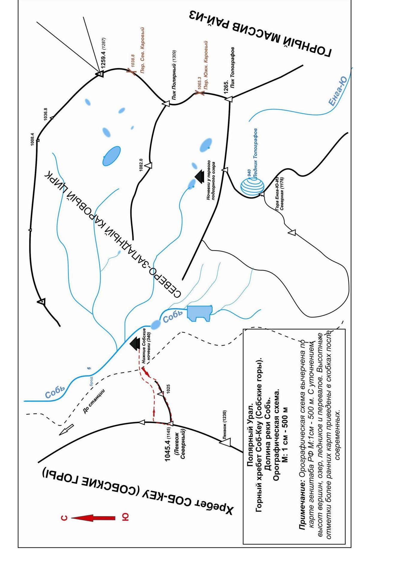
Region: Ural Federal District of the Russian Federation (UFD), border of Yamalo-Nenets Autonomous Okrug — Tyumen Oblast, Komi Republic.
Mountain country: Polar Urals
Gorge: valley of the Sob river
Ridge: Sob-Keu mountain range (Sobskie mountains)
Peak: Peak 1145 (Lekvoz Northern)
Route: "Via the north-eastern ridge through peak 1025"
Level of difficulty: approximately 2A (winter) category of difficulty
Prepared by: Seryakov S.V., Zhuravlev S.V.
July 2015
Σ и-и и виооии иіңноол
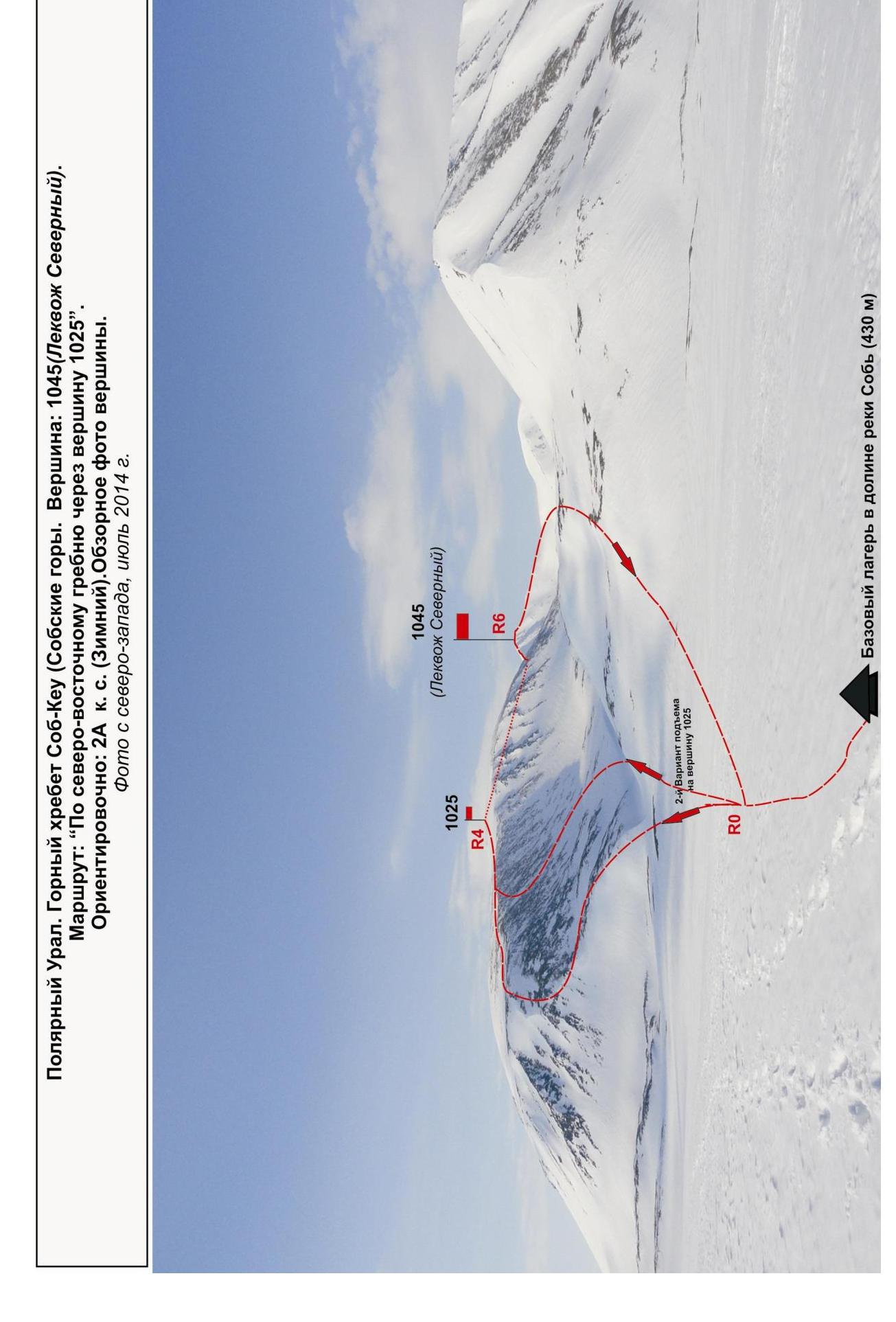
Photo from the northwest, July 2014
Passport
- Section number according to KMGV — 8.3. Polar Urals, Sob-Keu mountain range (Sobskie mountains).
- Name of the peak: Peak 1145 (Lekvoz Northern).
- Height: 1145 m.
- Route: "via the north-eastern ridge, through peak 1025".
- Category of difficulty: approximately 2A (winter) category of difficulty.
- Character of the route — snow-ice (winter).
- Height difference of the route: 645 m
- Length of the route: 4000 m
- Length of technical sections: 1 category of difficulty — R1 — 450 m, 2 category of difficulty — R2 — 750 m, 3 category of difficulty — R3 — 0 m, 4 category of difficulty — R4 — 0 m, 5 category of difficulty — R5 — 0 m, 6 category of difficulty — R6 — 0 m.
- Average steepness: — 40°.
- Pitons used:
Used in total on the route:
- rock pitons — 0 pcs
- chocks — 0 pcs
- stationary pitons — 0
- ice screws — 0
- removable pitons — 0
Left on the route: total — 0 pcs; including pitons — 0.
- Departure on the route — 8:30, May 3, 2014.
Reached the summit — 12:30, May 3, 2014. Returned to the base camp — 16:00, May 3, 2014.
- Team's total climbing hours — 7 hours.
- Leader: S. Seryakov (Vorkuta, 3rd sports category).
Participants:
- N. Gryaznov (Vorkuta, 3rd sports category)
- R. Lakomy (Vorkuta, 3rd sports category)
- A. Kabanov (Vorkuta, 3rd sports category)
- S. Salnikov (Vorkuta, 3rd sports category)
- V. Mayer (Vorkuta, 3rd sports category)
- Coach: Zhuravlev Sergey Vasilyevich, (Candidate Master of Sports, instructor-methodologist 1st category, Syktyvkar).
Description of the peak.
Peak 1145 m (Lekvoz Northern) — north of peak 1230 m (g. Lekvoz), a nodal peak of the Sob-Keu mountain range (Sobskie mountains). Located on the main watershed ridge of the Polar Urals, on the border:
- Europe and Asia,
- Yamalo-Nenets Autonomous Okrug (YaNAO) of Tyumen Oblast and Komi Republic,
- Ural and Northwestern Federal Districts of the Russian Federation.
Peak 1145 m (Lekvoz Northern) — a clearly expressed mountain, easily identifiable from the west and east on the main watershed ridge. From the source of the Sob river, only the upper part is visible. The name is not indicated on the General Staff map, determined orographically, relative to the nodal peak of the ridge — Lekvoz (1236), serves for identification of the peak.
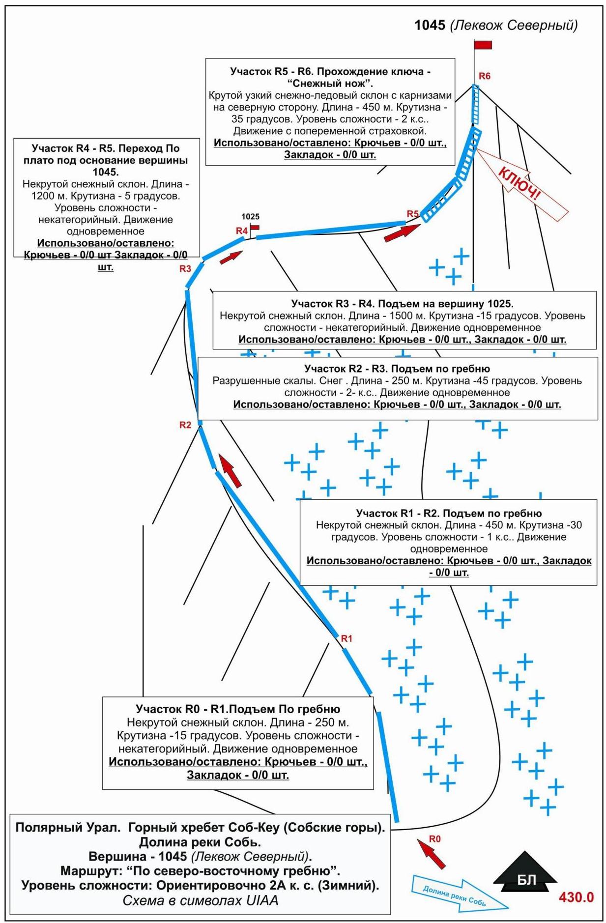
Description of the route.
The route "Via the north-eastern ridge through peak 1025" — a training and educational combined route 2A (winter) category of difficulty, with a set of natural obstacles. Passing this route has not only aesthetic but also practical sports significance, as it allows within the ascent to practice insurance and self-insurance techniques on a complex snowy ridge.
Equipment.
To complete the ascent as part of a training and sports group of 6 people (5 participants + instructor) on the route, the following special equipment is required:
- personal — standard, including crampons and ice axe
- group — main rope 10 mm — 2×50 m
Approach.
The ascent is made from the parking lot at the northern slope of peak 1025. Approach to the parking lot: from the railway station Polar Urals, from Lake Perevalnoe, go upstream along the left bank of the Sob river to the foot of peak 1025 (from the station 3.5 hours on skis or snowshoes).
Technical part.
The technical part of the route begins 100 m from the base camp — the base of the north-eastern ridge.
- Slope 15°
- Exit to the snowy ridge with a steepness of up to 30°
- Exit to the snow-rock slope with a steepness of up to 45°
On the slope to the right and up in rope teams with simultaneous belay. Exit to the plateau of peak 1025.
Gentle ascent along the slope to the dome-shaped peak 1025, from it — approach to the beginning of the ascent to 1045, movement along a wide, gentle plateau-like ridge to the base of the dome of peak 1145 (Lekvoz Northern).
Here the ridge becomes steeper and significantly narrower. Organization of belay is required. The path to the summit — along the snowy ridge. Movement on the left side of the ridge (on the right — cornices).
Key section of the route.
Before exiting to the summit, the ridge narrows to half a meter wide ("Snow knife"). Snow is dense, movement in crampons, in rope teams, with step cutting in some places. Steepness of the ridge 20°. Along the entire length of the ridge — overhanging cornices on the northern side.
Requires:
- mandatory alternate belay
- posting observers for the state of the slope
Summit.
Clearly expressed rock blocks — a small area. Marked with a geodetic triangulation sign.
Descent. Along the northern ridge in the direction of the pass. Narrow snowy ridge (20 degrees), bypassing two rock "gendarmerie" on the left. Movement in rope teams, with alternate belay through ice axe in some places.
After flattening of the ridge, not reaching the pass:
- descent to the right into the cirque along a snowy slope (30 degrees);
- then the slope flattens;
- descent to the base camp.
Recommendations for the instructor
The route is more complex than the traditional route 1B category of difficulty, can be used for training groups NP-2, as a credit ascent only with good technical preparation of participants, as well as with additional training on:
- organization of intermediate belay points and base stations,
- belay techniques,
- self-insurance on snowy terrain.
1045 (Lekvoz Northern)
Polar Urals. Sob-Keu mountain range
Peak: 1145 (Lekvoz Northern) Route: "via the north-eastern ridge, through peak 1025". Level of difficulty: approximately 2A (winter) category of difficulty. Character of the route: snow-ice (table of natural obstacles on the route)
| № section | Length | Steepness | Character of relief | Category of difficulty | Number of pitons/chocks |
|---|---|---|---|---|---|
| APPROACH | From the base camp (height mark — 340 m) to the foot of peak 1025 — 10 minutes. Ascent non-categorized, along a snowy slope 10–15°. | ||||
| R0–R1 Ascent along the snowy slope to the base of the ridge. | 250 | 15 | Snow. | n/c. | Used 0 / 0 Left 0 / 0 |
| R1–R2 Ascent along the snowy ridge. | 450 | 30 | Snowy ridge. Snow. | 1 | Used 0 / 0 Left 0 / 0 |
| R2–R3 Passage of the snow-rock slope. | 350 | 45 | Unstable rocks, snow. | 2- | Used 0 / 0 Left 0 / 0 |
| R3–R4 Exit to peak 1025 m. | 1500 | 15 | Dome. Snow. | n.c. | Used 0 / 0 Left 0 / 0 |
| R5–R6 Approach to the foot of 1045 m. | 1200 | 5 | Plateau-like wide ridge. Snow. | n.c. | Used 0 / 0 Left 0 / 0 |
| R5–R6 Passage of the key section — "Snow knife", exit to peak 1045 m. | 400 | 35 | Snowy ridge, in the upper part narrow to 0.5 m. On the northern slope — cornices | 2 -2+ | Used 0 / 0 Left 0 / 0 |
| R6 — peak 1145 m (Lekvoz Northern) | Rocky tower on a talus dome. Marked with a triangulation sign. Record left in a tour under the sign. | ||||
| DESCENT | Along the watershed ridge to the north to the pass, then along a weakly expressed ridge to the east to the expansion of the ridge and the beginning of the slope and descent into the eastern cirque along a snowy slope (approximately route 1B category of difficulty). |
Summary
Length of the route — 4150 m. Average steepness — 30°. Height difference — 645 m. Character of relief — snow-ice.
Technical sections: 1
- category of difficulty — 2 sections — 800 m
- 2 category of difficulty — 4 sections — 1200 m
- 3 category of difficulty — 0 sections — 0 m
- 4 category of difficulty — 0 sections — 0 m
- 5 category of difficulty — 0 sections — 0 m
- 6 category of difficulty — 0 sections — 0 m
Pitons and chocks used: 0 pcs. Pitons and chocks left: 0 pcs.
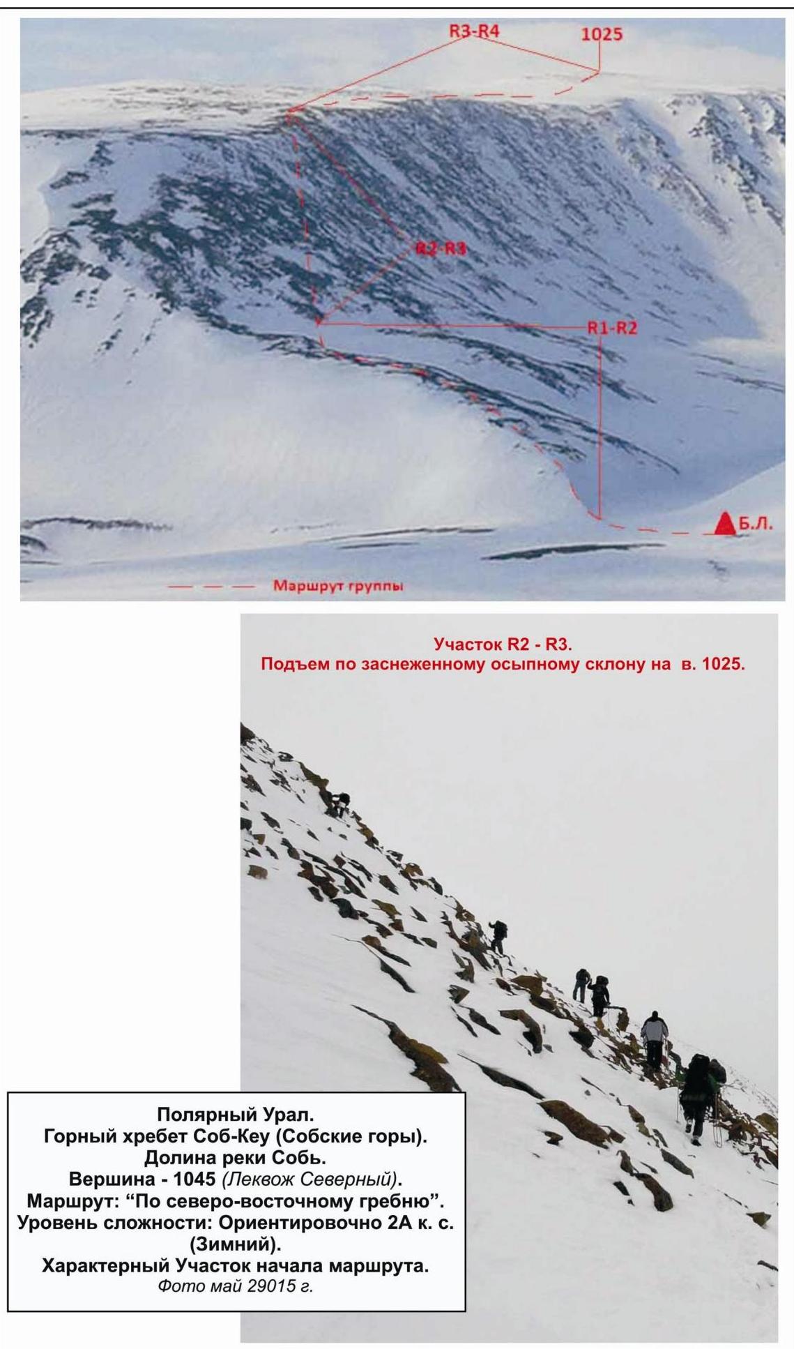
Section R2–R3. Ascent along a snowy talus slope to peak 1025 m. is missing, replaced with a similar phrase to maintain the same tone and style as the original translation."}The summit of peak 1045 m (Lekvoz Northern)