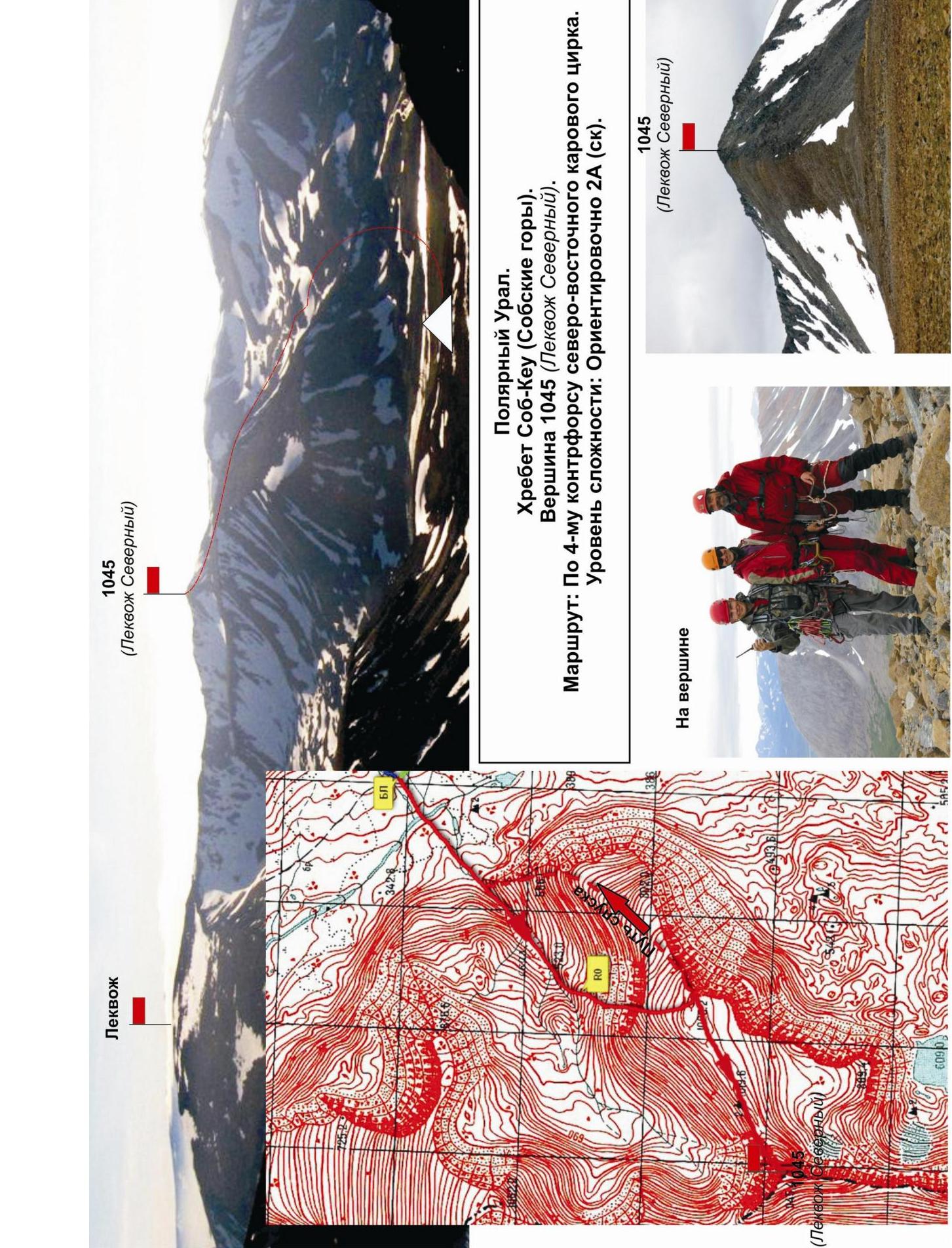
Polar Urals, Sob-Keu mountain range (Sobskie mountains). Section in KMGV - 8.3. Peak 1145 (Lekvoz Severny). Route: via the 4th counterfort of the north-eastern kar cirque. Category of difficulty approximately 2A (rocky)
Leader: A. Goletarov
E-mail — zhur58@rambler.ru
Report on the first ascent of the mountaineering route to peak 1145 (Lekvoz Severny) via the route: "Via the 4th counterfort of the north-eastern kar cirque"
At the annual alpinada event "Cup of NP 'Klub severnykh puteshestvii Sauk-Pai' 2015" (fourth stage, class "First ascents")
Region: Ural Federal District of the Russian Federation (UFD), Yamalo-Nenets Autonomous Okrug of Tyumen Oblast. Mountain country: Polar Urals. Valley: Valley of the Sob River. Ridge: Sob-Keu mountain range (Sobskie mountains). Peak: 1045 m (Lekvoz Severny). Route: "Via the 4th counterfort of the north-eastern kar cirque". Category of difficulty: approximately 2A (rocky). Prepared by: Goletarov A., Zhuravlev S. V. July 2015
1045 m (Lekvoz Severny)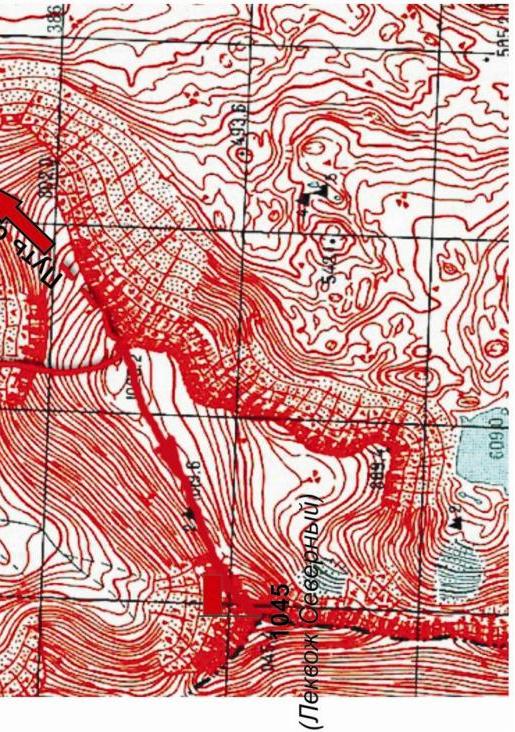
Sob-Keu ridge (Sobskie mountains). Peak 1045 (Lekvoz Severny). Route: via the 4th counterfort of the north-eastern kar cirque. Level of difficulty: approximately 2A (rocky).
Passport
- Section number according to KMGV — 2010 — 8.3.
Polar Urals, Sob-Keu mountain range (Sobskie mountains), valley of the Sob River.
- Name of the peak: Peak 1045 (Lekvoz Severny), height: 1145 m
- Route: via the 4th counterfort of the north-eastern kar cirque
- Category of difficulty: proposed 2A
- Character of the route — rocky.
- Height difference of the route: 600 m
- Length of the route: 2220 m
- Length of sections with the highest category of difficulty:
1 cat. — 3 sections — 1500 m, 2 cat. — 2 sections — 200 m, 3 cat. — 0 sections — 0 m, 4 cat. — 0 sections — 0 m, 5 cat. — 0 sections — 0 m, 6 cat. — 0 sections — 0 m
- Average steepness: main part of the route — 35 degrees, key section — 45 degrees.
10. Number of pitons used:
Total number used on the route:
- rock pitons — 0
- chocks — 0
- stationary bolt pitons — 0
- ITO — 0
- removable bolt pitons — 0. Number of "pitons" left on the route: total — 0; including bolt pitons — 0.
- Departure for the route — 8:00, July 3, 2015.
Reached the summit — 13:00, July 3, 2015. Returned to base camp — 15:30, July 3, 2015.
- Team's walking hours: 5 hours.
- Leader: A. Goletarov (Inta, 2nd sports category).
Team members:
- V. Disnenko (Inta, 2nd sports category)
- S. Nikolaeva (Voronezh, 2nd sports category)
- Coach: Zhuravlev Sergey Vasilievich (Syktyvkar, Candidate for Master of Sports, instructor-methodologist of the 1st category).
Description of the Sob-Keu ridge (Sobskie mountains)
The Sob-Keu mountain range (Sobskie mountains) is located in the main watershed ridge of the Polar Urals, on the border:
- between Europe and Asia,
- between the Ural and North-Western Federal Districts,
- between the Yamalo-Nenets Autonomous Okrug (YaNAO) of Tyumen Oblast (eastern slopes) and the Komi Republic (western slopes).
Sob-Keu is a short meridional ridge stretching from north to south from the valley of the Sob River (Shlem mountains) to the Payer mountain massif. The nodal peak of the ridge is Lekvoz (1237 m).
Description of the peak
Peak 1145 (Lekvoz Severny) is one of the peaks of the Sob-Keu mountain range (Sobskie mountains), a pronounced talus pyramid with kar cirques on the north-eastern, south-eastern, and south-western slopes.
- Height — 1145 m — official height mark on the maps of the General Staff of the Russian Federation. Scale: 1 cm — 500 m.
- The peak is located north of the nodal peak — Lekvoz of the Sob-Keu ridge (Sobskie mountains) — in the main watershed ridge.
- The eastern slopes of the mountain are in Asia, the western slopes are in Europe.
The name is unofficial, determined by the orographic principle, which allows identifying the peak as an object of sports ascents.
Description of the route
The route: "Via the 4th counterfort of the north-eastern kar cirque, 2A category of difficulty (rocky)" — was traversed within the framework of the mountaineering competition "4th stage of the Cup of NP 'Klub severnykh puteshestvii Sauk-Pai' 2015" (class "First ascents").
The route is educational: technical, saturated, but not prolonged, which allows, in case of worsening weather, to stop the ascent and safely descend to the valley of the Sob River to the base camp from any section. The rocky character allows for maximum safety during educational and sports ascents with checking and practicing skills of movement on rocky terrain.
Equipment
To complete the ascent as part of an educational and sports group of 6 people (5 participants + instructor), the following special equipment is required on the route:
Personal:
- Standard issue
Group:
- Main rope 10 mm — 3×50 m
- Rock hammer — 2 pcs
- Rock pitons — 6 pcs
- Chocks — 6 pcs
- Quickdraws — 6 pcs
- Slings — 8 pcs
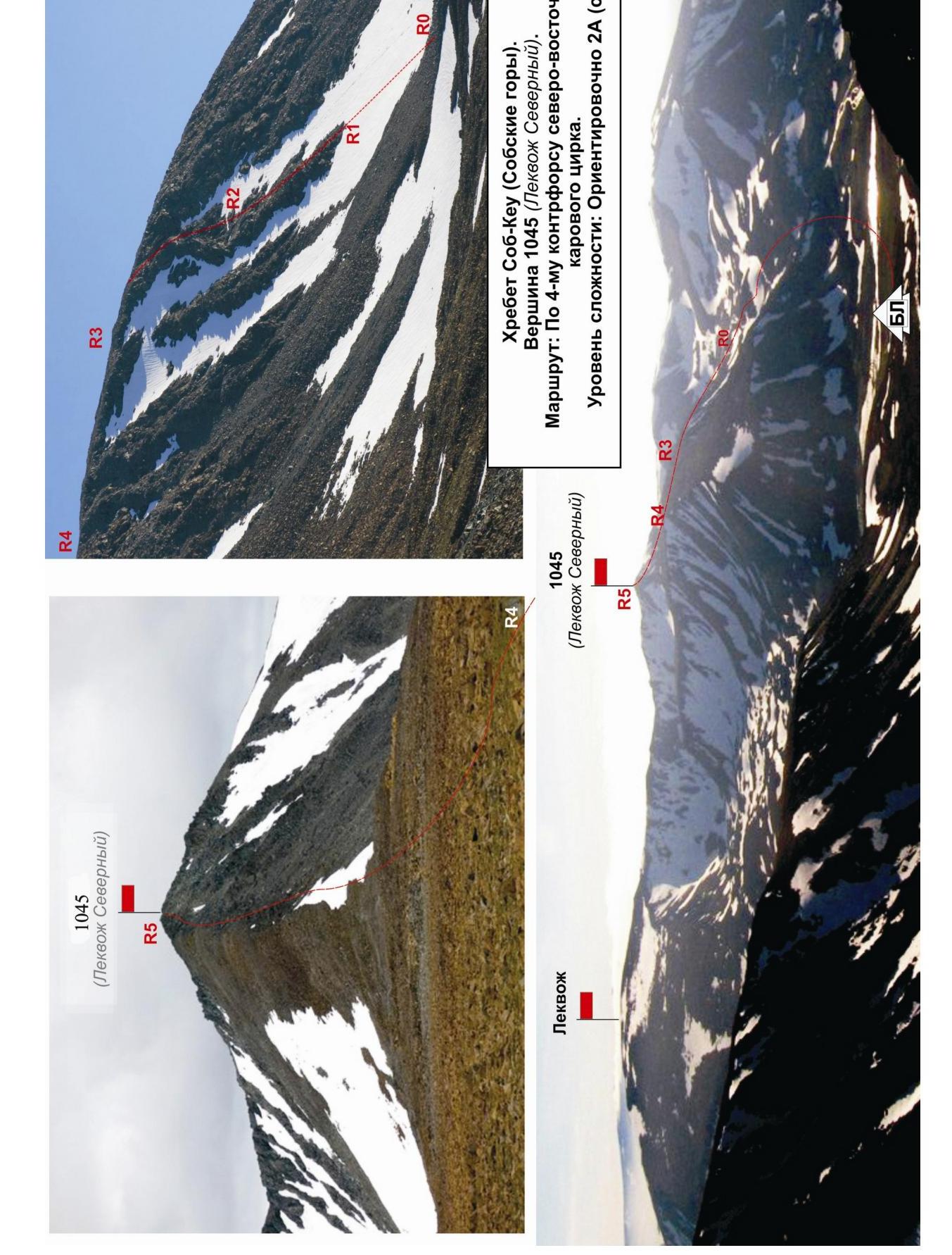
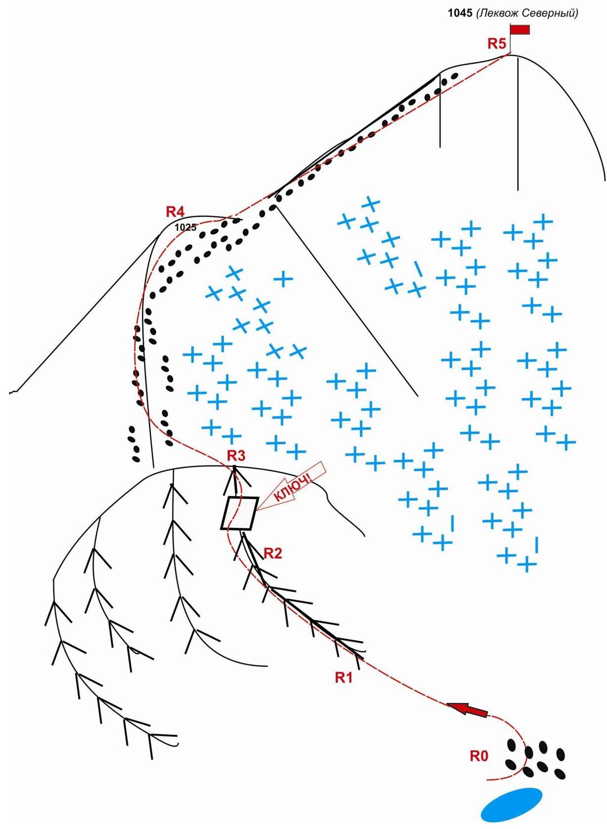
Approach
From the Polar Urals railway station on the northern railway, follow the valley of the Sob River — in winter on skis, in summer through mountain tundra — to the confluence of three streams forming the Sob River — "Nizhnie Sobskie bivouac".
Then ascend along the valley of a nameless stream to a kar lake located under the north-eastern kar cirque (from base camp — 1.5 hours).
Then:
- Ascend via talus to a clearly visible platform on the talus ridge under the fourth (from left to right) counterfort of the kar cirque.
- The platform is a convenient place to put on harnesses and helmets, prepare equipment.
- From the platform, ascend via talus to the base of the rocky ridge of the counterfort.
At the base of the counterfort, organize teams, as this is where the technical section of the route begins.
Technical part
Move upwards along the destroyed rocky ridge, consisting of large rocky blocks, requiring not only rock climbing skills but also organization of intermediate belay points through bends and ledges.
Ascend along the ridge to slabs. Inclined slabs require friction climbing skills.
Approach the rocky bastion with an overhang via the slabs. The overhang is bypassed on the right via a rocky wall — this is the key section of the route.
Key section of the route — rocky wall. Inclined monolithic dense rocks. Many convenient ledges for organizing intermediate belay points using large slings.
During the passage, the following equipment was used:
- Medium-sized Camalots (3 pieces)
After passing the key section:
- move along the destroyed rocky ridge,
- then ascend via talus (kurum) to a height with a mark of 1025 m (the mark is on the map, scale: 1 cm — 500 m, General Staff of the Russian Federation),
- then ascend via a wide talus ridge to the summit.
The ascent is non-categorized, and in summer, it does not present technical difficulties.
Summit
A clearly visible talus dome. Descend from the summit via the north-eastern slope. Non-categorized. Polar Urals. Sob-Keu mountain range (Sobskie mountains). Peak — 1045 m (Lekvoz Severny). Route: "Via the 4th counterfort of the north-eastern kar cirque". Level of difficulty: approximately 2A category (rocky). Diagram in UIAA symbols.
Polar Urals. Sob-Keu mountain range (Sobskie mountains). Peak: 1145 (Lekvoz Severny). Route: "Via the 4th counterfort of the north-eastern kar cirque". Level of difficulty: approximately 2A category (rocky).
(table of natural obstacles on the route)
| Section | Length | Steepness | Character of terrain | Cat. of diff. | Number of pitons/chocks |
|---|---|---|---|---|---|
| APPROACH | From base camp in the upper reaches of the Sob River near the first foothill lake — to the base of the couloir, 30 minutes via mountain tundra, talus, snow. | ||||
| R0 — Platform on talus above kar lake. | Start of the route. | ||||
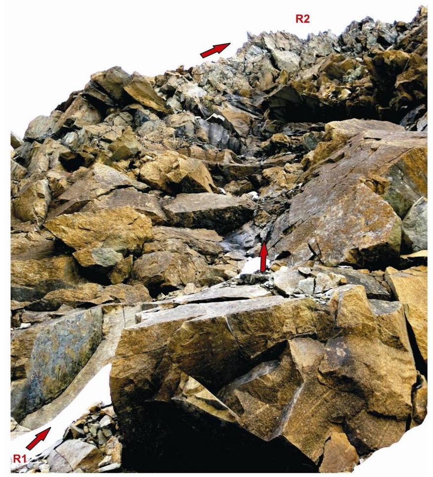
| R0–R1 Ascent via talus to the base of the 4th counterfort (from left to right) | 300 | 25 | Talus. | n/c, 1- | Used 0/0 Left 0/0 |
| R1 — rocky shelf at the base of the 4th counterfort | Place for organizing teams | ||||
| R1–R2 Ascent onto the rocky ridge of the counterfort and passage along the ridge to an inclined slab | 150 | 45-50 | Destroyed rocks. Movement is simultaneous, on a shortened rope, on separate sections with alternate belaying. | 2- | Used 0/0 Left 0/0 |
| R2–R3 KEY! Passage of the slab. Passage of the inclined wall, rocky ridge, and exit onto the north-eastern slope of the peak. | 50 | 55 | Dense, smooth slabs. Friction climbing. Rocky inclined wall — monolith. | 2+ | Used 0/3 Left 0/0 |
| R3–R4. Ascent to height 1025 m. | 200 | 30 | Destroyed rocky ridge. | 1 | Used 0/0 |
| Talus. | Left 0/0 | ||||
| :-- | :-- | :-- | :-- | :-- | :-- |
| R4–R5. Talus and snow-covered ridge. | 1000 | 20 | Gentle and prolonged talus ridge | 1, n/c | Used at 0/0 Left 0/0 |
| R5 — peak 1145 m (Lekvoz Severny) | Talus dome. Cairn in the north-eastern part. | ||||
| Descent: | From the summit via the ascent route to height 1025 m. Then via the destroyed south-eastern ridge to the valley of the Sob River |
Total
Length of the route — 1700 m. Average steepness — 35°. Character of terrain — combined.
Technical sections:
- 1 cat. — 3 sections — 1500 m
- 2 cat. — 2 sections — 200 m
- 3 cat. — 0 sections — 0 m
- 4 cat. — 0 sections — 5 m
- 5 cat. — 0 sections — 0 m
- 6 cat. — 0 sections — 0 m
Number of pitons and chocks used: 0/3 pcs. Number of pitons and chocks left: 0/0 pcs.
Polar Urals. Sob-Keu mountain range (Sobskie mountains). North-eastern kar cirque. Peak — 1045 (Lekvoz Severny). Route: "Via the 4th counterfort". Level of difficulty: approximately 2A category (rocky).
Photo of a section of the route (R1–R2). Photo. July 2015.